NovAtel Inc. announced a new initiative and engineering team to develop functionally safe GNSS positioning technology for fully autonomous applications. The company leverages its extensive experience developing safety-critical systems for the aviation industry to meet the future safety thresholds required for driverless cars and autonomous applications in agriculture, mining, and other government, military and commercial markets.
In early 2015, NovAtel formed a specialized Safety Critical Systems Group of engineers with backgrounds in functional safety as well as all aspects of GNSS and inertial navigation systems (INS) technology. The Safety Critical Systems Group is focused on creating positioning products that will meet the exceptional performance and safety requirements of autonomous vehicles at the necessary production volumes and at the required price point.
The company has extensive background working within safety critical requirements. Michael Ritter, president & CEO stated, “Aviation in North America relies on NovAtel technology to ensure safe navigation and landing.” Ritter added, “The Federal Aviation Administration’s WAAS, and other global Space Based Augmentation Systems (SBAS), have relied on certified NovAtel GNSS receivers for many years as the foundation of their systems. With full GNSS signal and constellation support needed to solve the performance criteria of autonomous driving, NovAtel is uniquely qualified to deliver the optimal solution that will keep us all safe as we drive the autonomous highways of the future.”
Jonathan Auld, Novatel’s director of Safety Critical Systems.
NovAtel manufactures high-precision GNSS receivers, antennas and subsystems, with expertise in sensor integration, specifically that of GNSS and INS. Through its TerraStar correction service, NovAtel also offers a global Precise Point Positioning (PPP) correction solution that is already designed for safety-of-life applications.
With work underway for more than a year, NovAtel plans to achieve ISO/TS 16949 compliance by the end of 2016. This is an early key milestone in the Safety Critical Systems Group’s path, to be followed by an ISO 26262 compliant product.
Jonathan Auld is director of Safety Critical Systems at NovAtel. He first joined the company in 2000 and has held positions as a GNSS test engineer, test group manager, director of technology development, and director of portfolio management.
Hexagon AB has entered a strategic partnership with Huawei, an information and communications technology (ICT) company, to deliver smart city solutions.
With most of the world’s population living in cities, safety and infrastructure challenges are at an all-time high. Hexagon and Huawei are working together to meet this global challenge by integrating Huawei’s communications hardware with Hexagon’s safety and infrastructure software solutions.
The combined solution improves inter-agency collaboration and leverages big data analytics to better predict, prepare for, and respond to urban area challenges.
Safety is a primary focus of the combined solution, offering cities connected command centers with integrated systems that maximize efficiencies in all preparedness and response areas. Huawei’s contributions include technologies from its Safe City portfolio such as high-definition video surveillance, broadband trunking and IP-based conference calling systems. Hexagon’s emergency response, utilities management and transportation software solution portfolio, which includes computer-aided dispatch, will provide the visibility and decision-support backbone to enable customers to think and act more nimbly.
“Huawei’s technologies, expertise and global coverage, especially in emerging market areas, nicely complement our ability to deliver smart city solutions to law enforcement, government, security personnel and other public service agencies around the world,” said Ola Rollén, Hexagon president and CEO.
“Safety, including efficient response to crisis management, will continue to be a key challenge for urban management, especially in developing economies that are stimulating population movement into these areas,” said Yan Lida, president of Huawei Enterprise Business Group. “Together with Hexagon, the global authority on safety and infrastructure solutions, our extensive ICT technologies that help architect safe city infrastructure will help make societies safer.”
TCS’ Matt Vincent poses with public safety gear that includes Taoglas Storm Antenna at APCO.
It is refreshing to see nascent technology such as indoor location being used to enable accurate emergency services response. That’s what’s going on right now as beacons, Wi-Fi and other technology that works inside, where GPS doesn’t work, is being tested nationwide by companies hoping for government adoption. With new FCC regulations that are finally trying to keep up with commercial location products, it may be a reality soon. What really drove location into wireless handsets was the 1990s FCC regulations — will they now drive indoor positioning?
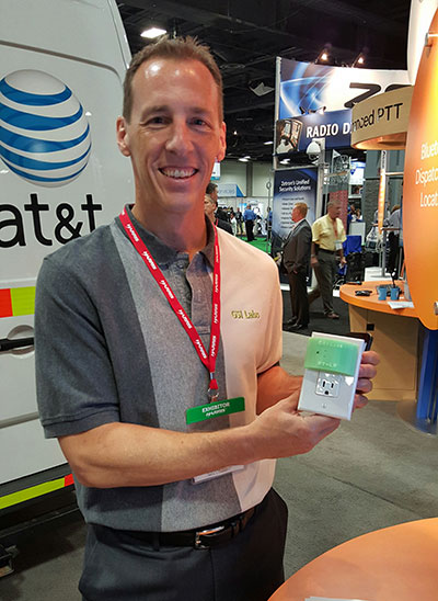
GSI Labs’ John Martin holds indoor beacon at APCO.
WASHINGTON — The same technology that allows consumers to find products indoors will allow emergency personnel to locate people in trouble in the coming years, said officials at the Association of Public-Safety Communications Officials (APCO) annual meeting here, held Aug. 16-19.
Companies are using existing commercial technologies, also used by retailers to determine customer preferences, to provide indoor location in combination with the National Emergency Address Database. This provides public-safety answering points, or PSAPs, accurate addresses and positions to dispatch emergency services to allow first responders to find people on specific floors and in rooms, not huge areas.
Beacons and Wi-Fi seem to be the lead technologies in use for emergency indoor location. Longmont, Colo.-based Intrado installed 65 Apple iBeacons at the Washington Convention Center to showcase its developing indoor positioning technology.
“Old 9-1-1 technology was just a dot on the map. Now people are saying, ‘how can Starbucks can find me, but 9-1-1 can’t?’” said John Snapp, Intrado senior technical officer.
Another company, TeleCommunication Systems, is getting into the indoor public safety market with its LocatE9-1-1 product that leverages the company’s indoor location engine, or ILE. The ILE connects to multiple databases that can be used during a 9-1-1 call to determine what location information is available for the wireless device.
“Deep inside buildings, location technology often fails us. Sometimes emergency workers have to rely on verbal information [from people at the scene],” said Tim Lorello, TCS senior vice president and chief marketing officer. “We are a location aggregator. However, we do know location won’t be deployed everywhere, but there are multiple technologies tied to Wi-Fi hotspots, barometric pressure and Bluetooth.”
In addition to government agencies, wireless carriers are taking notice of the indoor positioning capabilities for public safety. At APCO, GSI Labs, a 20-year-old business, was in the AT&T booth displaying its codeBlue-911 beacon system. “We think that for bigger venues such as warehouses and stores, this is a great public safety tool. The [Bluetooth Low Energy] beacons have about 20-to-50-foot accuracy, depending on the battery,” said GSI Labs’ John Martin. “A security company is looking at using the beacons to monitor employees during the night.”
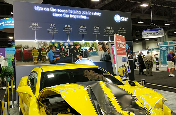
OnStar booth features wrecked car to portray emergency messaging capabilities at APCO.
FCC Still at Forefront of Location Accuracy Requirements
In an address at the conference, FCC Chairman Tom Wheeler said that the agency has taken steps to increase the reliability of the nation’s 9-1-1 system. “Uber can pinpoint [a potential customer]. We won’t tolerate 9-1-1 failures,” said Wheeler, who also called for a national maps database.
Some people newer to the location industry don’t remember it was the enhanced 9-1-1 FCC rules that drove the installation of GPS into cell phones in the mid-1990s. In several presentations at APCO, it was noted that more than 80 percent of all emergency calls are made with a wireless device, not landline.
The FCC announced new rules this year that require wireless operators to provide dispatchable location within 50 meters with these new deadlines and conditions: 40 percent of all wireless 9-1-1 calls within 2 years; 50 percent within 3 years; 70 percent within 5 years; and 80 percent within 6 years.
If anyone doesn’t think the FCC is the 800-pound regulatory gorilla for location, then they have missed the LightSquared GPS signal interference saga. According to published reports, LightSquared has hired Reed Hundt, former FCC chairman, as an attorney representing the company.
LightSquared, which is trying to emerge from bankruptcy, has been seeking FCC approval to transfer its spectrum licenses to its new entity. The company is trying to see if the GPS interference issues can be resolved.
In other APCO news, Time Machines rolled out its TM 2000A timing device that costs $499.95. The big deal about the timing device is the price — which has many of the same features that competitors offer for more than $5,000, said Doug Ehlers, Mindshare by CSS president, a sister company of Time Machines, who also said the company is expanding its distribution in Europe.
Gimbal Partners with Do It Outdoors Media
While emergency networks are getting big, the commercial networks are continuing to make inroads with advertising agencies and partners. Location and proximity-based marketing company Gimbal recently partnered with Do It Outdoors Media in a deal that will use Gimbal’s beacon technology.
Gimbal said that Do It Outdoors Media, which is the largest national mobile billboard and field marketing company, will create a smartphone campaign that provides proximity-based consumer offers to opt-in users.
Beacons will be placed in Do It Outdoors Media’s mobile billboard units, which are owned and operated by the company. In addition, there will be product placement on Segways, jet packs, brand ambassador teams and other marketing sites.
Gimbal says that when a consumer enters into a beacon zone, which is effective from 50 meters away, content will be delivered through a push notification within an advertiser’s or a third-party mobile app.
In other location news:
While a small trade show for a focused group of government communication professionals, APCO drew 5,700 attendees, with 282 exhibitors. Conference organizers said it was the highest attended show in seven years.
An updated version of the former GPS-Wireless conference will take place Dec. 2-3 at the Crowne Plaza San Francisco Airport Hotel. The conference, Location IoT, will focus on new markets for M2M and the Internet of Things. Topics will include indoor location markets, connected vehicles and many others. Two hosted networking receptions are included. Contact me, Kevin Dennehy, at kdennehy @g psworld.com for more information.
With Exelis RangeVue, a high-performance GIS visualization engine provides real-time updates of critical operational elements.
Exelis has launched its first airspace situational awareness tool designed specifically for unmanned aerial system (UAS) operations in the United States. Symphony RangeVue puts real-time Federal Aviation Administration (FAA) surveillance data, flexible background maps and weather information in the hands of UAS operators and test range personnel. The system provides significant improvements to the safety and efficiency of UAS operations, whether on the test range or in the field.
Symphony RangeVue enables UAS operators and test range personnel to have access to both real-time and historical surveillance information via a web-hosted platform, helping to manage mission operations from multiple locations with full visibility of assets. Symphony RangeVue can be used as a command center decision-support and post-event analysis tool, or in the field as a sense-and-avoid addition to UAS ground control stations. Flexible geo-fencing tools alert operators when a UAS approaches airspace boundaries or when other aircraft are in the vicinity.
“For the first time, UAS operators and test range personnel will have the same situational awareness currently available to general aviation pilots through traffic information broadcast services. This capability is available without having to install avionics surveillance equipment on the UAS aircraft,” said Ed Sayadian, vice president of Civil and Aerospace Solutions for Exelis. “Leveraging the FAA’s own surveillance data combined with advanced sense-and-avoid alerting capabilities, Symphony RangeVue will significantly increase the safety of UAS operations.”
Symphony RangeVue combines a high-performance visualization engine with the vast network of Exelis NextGen surveillance data, including all of the FAA’s surveillance systems: automatic dependent surveillance-broadcast; en route radar; terminal radar; airport surface detection equipment-X; airport surface surveillance capability; and wide area multilateration. It also integrates locally deployed surveillance assets to deliver hyperlocal situational awareness.