Tag: satellite navigation

  • New positioning framework cuts satnav convergence time to seconds

    New positioning framework cuts satnav convergence time to seconds

    Asynchronous GBPS can improves both convergence speed and positioning reliability

    Precise point positioning (PPP), a high-accuracy GNSS technique, offers the advantage of centimeter-level positioning without relying on local reference stations. However, PPP often requires many minutes to achieve full precision, making it less suitable for dynamic environments.

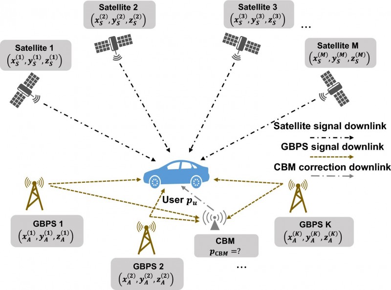
    Previous efforts have shown that ground-based positioning systems (GBPS) can accelerate convergence by providing additional geometric constraints. Yet most GBPS solutions depend on highly accurate time synchronization among base stations, which increases infrastructure costs and limits deployment flexibility.

    Asynchronous GBPS (A-GBPS) remove this synchronization burden, but their potential for augmenting PPP has remained largely unexplored. Deeper investigation into practical PPP augmentation with A-GBPS is needed.

    Researchers from the Department of Electronic Engineering at Tsinghua University report a new GNSS augmentation framework in a study published (DOI: 10.1186/s43020-026-00200-4) in the journal Satellite Navigation. The researchers developed a tightly coupled positioning architecture that integrates GNSS with A-GBPS. By combining satellite and A-GBPS observations, the framework significantly accelerates positioning convergence and improves solution stability, offering a practical pathway toward more efficient high-precision navigation services.

    Rather than requiring all base stations to share the same clock, the new framework embraces their asynchronous nature. The researchers developed a method that uses a dedicated monitoring station to correct transmitter clock biases before integrating the measurements with GNSS observations. This allows the system to exploit the strong signal power and favorable geometry of ground-based transmitters without the operational burden of network-wide synchronization.

    The team first established a theoretical model showing that adding A-GBPS observations should reduce positioning uncertainty. Numerical simulations then demonstrated that adding A-GBPS can significantly strengthen geometric constraints, particularly in the directions where satellite-only positioning is weak. The benefits became even more pronounced after the positioning solution stabilized, suggesting that A-GBPS can complement GNSS throughout the positioning process.

    Field test results

    To test the approach under real-world conditions, the researchers deployed six A-GBPS base stations and conducted field experiments using a mobile receiver platform. Compared with GNSS-only positioning, the augmented system reached higher accuracy with faster convergence and delivered more stable positioning performance.

    The experiments also revealed an important engineering insight: adding more base stations generally improved performance, but the gains began to level off beyond about five or six stations. This finding may help future network designers balance positioning performance against deployment costs.

    The authors said the work demonstrates that high-precision PPP augmentation does not necessarily require tightly synchronized GBPS. Instead, asynchronous GBPS can provide valuable geometric information that improves both convergence speed and positioning reliability.

    Using existing 5G networks

    They said the results indicate that existing terrestrial communication facilities, like 5G, could potentially support future positioning services. Such an approach may offer a practical pathway toward more accessible high-precision navigation without high deployment expense and complexity, which usually associated with synchronized GBPS.

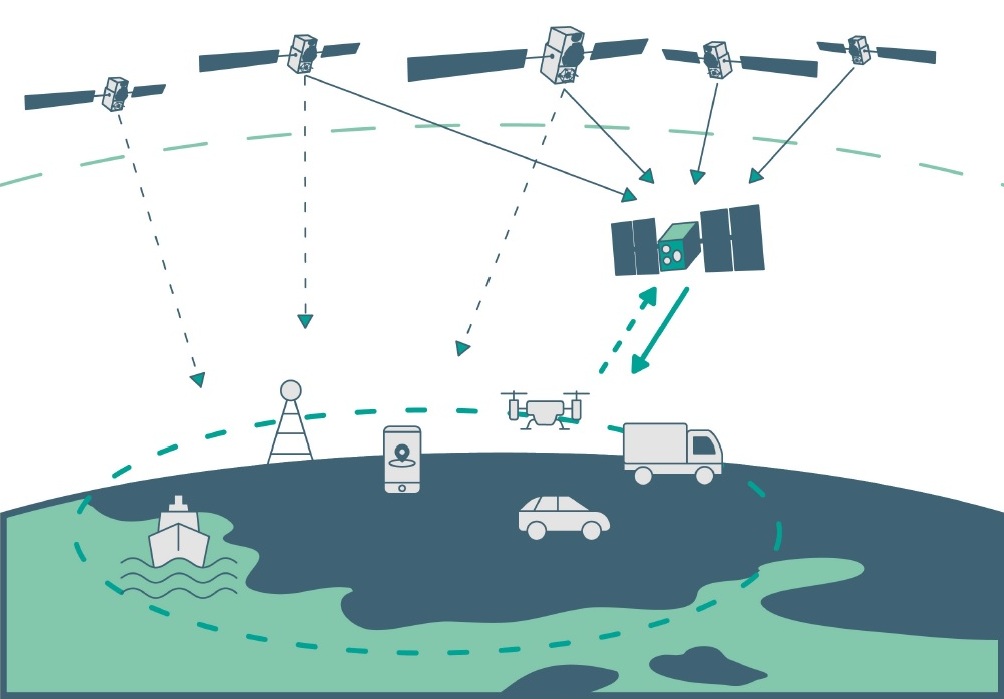
    The implications extend beyond navigation research. Faster and more reliable positioning could benefit autonomous driving systems, unmanned aerial vehicles, intelligent transportation networks, surveying operations, and mobile mapping platforms that depend on rapid access to precise location information. Because the framework is compatible with existing radio infrastructure, it may lower barriers to deployment and expand positioning coverage in challenging environments.

    The researchers note that future work will focus on eliminating the need for a dedicated monitoring station and evaluating performance under more complex urban conditions, where signal blockage and multipath interference are more prominent.

  • Topcon secures early access to Xona’s Pulsar satellite navigation service

    Topcon secures early access to Xona’s Pulsar satellite navigation service

    Topcon Positioning Systems has signed a commercial agreement with Xona to secure early-adopter access to Pulsar, Xona’s low Earth orbit (LEO) satellite navigation constellation. This agreement positions Topcon among Xona’s first commercial customers preparing to integrate Pulsar into future high-precision positioning workflows. 

    “The letter of agreement reinforces Topcon’s long-standing commitment to innovation and customer-driven technology leadership,” said Ron Oberlander, head of the Topcon Geomatics Platform. “It lays the groundwork for a new era of high-precision performance possibilities as LEO satellites come online. By proactively adopting next-generation navigation infrastructure, we strengthen our commitment to provide reliable, resilient, and future-proof solutions for our customers.”

    “Topcon understands where accuracy, continuity and confidence matter most for operators in the field,” said Bryan Chan, co-founder and VP of Strategy at Xona. “By adding a modern navigation layer into Topcon’s offerings, Pulsar will strengthen signal performance and resiliency in even the most challenging environments, ensuring Topcon customers can operate with greater confidence wherever their work takes them.”

  • Furuno and Xona Space Systems sign MoU to develop innovative LEO PNT solutions

    Furuno and Xona Space Systems sign MoU to develop innovative LEO PNT solutions

    Furuno Electric and Xona Space Systems have signed a Memorandum of Understanding (MoU) to collaborate on solutions using Xona Pulsar, a low-Earth-orbit positioning, navigation and timing (LEO PNT) service for next-generation satellite navigation.

    Through the agreement, both companies will leverage their respective technological expertise and business strengths to explore opportunities for delivering advanced and promising LEO PNT solutions.

    Furuno has been actively pursuing LEO PNT as a promising technology capable of complementing or even substituting for GNSS.

    LEO PNT refers to systems that use a satellite constellation of 200 to 400 satellites deployed in low Earth orbit at an altitude of 500 km to 2,000 km. The LEO constellation is designed for PNT rather than non-terrestrial networks to provide global positioning and timing services similar to GNSS, but with significantly better performance.

    Xona is a pioneer in LEO PNT technology and offers a commercial service called Pulsar, which uses a dedicated LEO PNT constellation of 258 satellites. Compared to conventional GNSS, this service enhances resiliency and improves the accuracy of positioning and timing — the proximity of LEO satellites to Earth makes their signal power about 100 times stronger.

    Pulsar adopts a signal architecture similar to GNSS for compatibility, making it easy to integrate into existing GNSS products. Integrating Xona Pulsar into Furuno’s products will provide an alternative to GNSS while significantly boosting performance by complementing existing GNSS services.

    Furuno’s Pulsar-enabled timing solutions allow users to maintain accurate synchronization even when GNSS is degraded due to unexpected failures, including jamming and spoofing, the companies said.

  • ESA explains Moonlight Initiative in new video

    ESA explains Moonlight Initiative in new video

    Screenshot: ESA
    Screenshot: ESA

    The European Space Agency (ESA) has released a new video describing the Moonlight Initiative, part of NASA’s Artemis program.

    ESA is a key partner in Artemis, which aims to return people to the Moon by the end of decade. Dozens of other international public and private missions are setting their sights on the lunar surface in the coming years.

    However, to achieve a permanent and sustainable presence on the Moon, reliable and autonomous lunar communications and navigation services are required. ESA is working with industrial partners on the Moonlight Initiative, to become the first off-planet commercial telecoms and satellite navigation provider.

    After launch, three or four satellites will be carried into lunar orbit by a space tug, and deployed one by one to form a constellation of lunar satellites. The number and specification of these satellites are being defined.

    The constellation’s orbits are optimized to give coverage to the lunar south pole, where sustained sunlight and polar ice make it the focus of upcoming missions.

    Moonlight will provide data capacities sufficient to serve these planned and future missions, with a navigation service that enables accurate real-time positioning for all lunar missions.

  • China investigates improving GNSS timing with lasers

    China investigates improving GNSS timing with lasers

    Image: fotojog/iStock/Getty Images Plus/Getty Images
    Image: fotojog/iStock/Getty Images Plus/Getty Images

    Chinese scientists say they have succeeded in an experiment that could improve satellite navigation and redefine the second as a unit of time, reports the South China Morning Post.

    The scientists performed the experiment in Urumqi, capital of Xinjiang Uygur autonomous region in western China. They placed two terminals in laboratories 113 km (70 miles) apart. Each terminal was equipped with a laser, a telescope and two optical frequency combs that measure exact frequencies of light. Laser pulses sent between the terminals allowed researchers to confirm the time.

    The research team was led by quantum physicist Jian-Wei Pan at the University of Science and Technology of China (USTC).

    Sending signals over long distances would enable a global network of optical clocks that can help improve the accuracy of satellite navigation services.

    China also is sending three atomic clocks to its Tiangong space station to establish a space-based timekeeping system of exceptional accuracy. The clocks can work together to measure time with 10-19 stability, missing only one second every few billion years, and is expected to be thousands of times more accurate than a hydrogen maser.

  • ESA plans for low-orbiting navigation satellites

    ESA plans for low-orbiting navigation satellites

    Photo:
    New PNT satellites will operate in low Earth orbit (LEO). (Image: ESA)

    News from the European Space Agency (ESA)

    Satellite navigation is headed closer to users. ESA’s Navigation Directorate is planning an in-orbit demonstration with new navigation satellites that will orbit just a few hundred kilometers in space, supplementing Europe’s 23,222-km-distant Galileo satellites.

    Operating added-value signals, these novel low-Earth-orbit (LEO) positioning, navigation and timing (PNT) satellites will investigate a new multi-layer satnav system-of-systems approach to deliver seamless PNT services that are much more accurate, robust and available everywhere.

    Global in coverage, free for everyone to use, GNSS such as Europe’s Galileo have already transformed our society, and due to their sheer omnipresence their influence continues to grow. In 2021, the population of satnav receivers reached 6.5 billion around the world, and the sector is projected to maintain a 10% annual growth rate in the years ahead. But in various respects the standard GNSS approach is nearing the limits of optimum performance — to get even better, added ingredients are becoming essential.

    “Satellite navigation has enabled a vast range of applications in recent years, but this very success is inspiring still more demanding user needs for the coming decade,” said Lionel Ries, head of ESA’s GNSS Evolutions R&D team, overseeing the agency’s LEO-PNT studies.

    “For use cases such as autonomous vehicles, ships or drones, robotics, smart cities or the industrial internet of things for control of factory systems, the positioning requirements are growing from the current meter-scale to centimeter scale or even more precise, based on continuously reliable signals that are available anywhere, anytime — even indoors —while able to overcome interference or jamming.

    “Up until now we have relied for positioning on the classical solution of GNSS such as Galileo, located in medium Earth orbit and based on L-band signals. Standard GNSS alone is not going to be able to fulfil all these future user demands. Instead Europe needs to seize the opportunity to investigate the potential of the kind of LEO constellations that are already on the way in the global market to enable new kinds of PNT services.”

    Simply by virtue of physics, with less of a distance to cover down to Earth, the signals from these LEO-PNT satellites can be more powerful, able to overcome interference and reach places where today’s satnav signals cannot reach.

    Additionally, by adopting novel navigation techniques and a wider range of signal bands the satellites can address particular user needs: for instance at lower orbits the satellites themselves move more rapidly relative to Earth’s surface — think of the International Space Station at 400 km that orbits the Earth every 90 minutes — which offers possible advantage in the time needed to reach very accurate positions. Also some bands could offer greater penetration in difficult environments while other bands could offer higher robustness and precision.

    Mega-constellations of hundreds or even thousands of low-orbiting satellites offer a means of acquiring continuous coverage for telecommunications services or Earth observation. (Image: ESA)
    Mega-constellations of hundreds or even thousands of low-orbiting satellites offer a means of acquiring continuous coverage for telecommunications services or Earth observation. (Image: ESA)

    The purpose of ESA’s plan to perform an in-orbit demonstration of low Earth orbiting satnav satellites is precisely to consolidate the types of signals, enabling technologies and their potential for future services.

    The plan is to build and fly an initial mini-constellation of at least half a dozen satellites to test capabilities and key technologies, as well as demonstrating signals and frequency bands for use by a follow-on operational constellation, in the same way that Europe’s GIOVE test satellites paved the way for Galileo. Success will place European industry in pole positions for follow-on commercial undertakings, as well as planned institutional programs.

    “Each individual satellite would be comparatively small, below 70 kg in mass, compared to a 700 kg current Galileo operational satellite,” added Roberto Prieto-Cerdeira, Galileo Second Generation satellite payload manager and LEO-PNT project preparation manager as part of ESA’s FutureNAV program.

    “They can be comparatively more streamlined because they can benefit from other means to calculate the accurate time without extremely precise atomic clocks on board — including relayed signals from the Galileo satellites above them. These satellites would also be built on a rapid batch production basis to save time and cost — we are targeting three years at the most from signing the contracts to the first satellites in orbit, the same kind of timescale achieved by GIOVE-A in the early 2000s.”

    A vision of future, layered, satellite navigation, stretching from Earth to the Moon. (Image: ESA)
    A vision of the future shows layered satellite navigation stretching from Earth to the Moon. (Image: ESA)

    “It is ESA’s ambition to ensure Europe maintains a world-class space industry, and navigation today forms the single largest downstream space sector, worth about €150 billion annually and growing at the rate of 10% per year,” said ESA Director of Navigation Javier Benedicto-Ruiz. “Standing still is not an option; instead we need to explore new technical avenues to spur European competitiveness and commercialization.”

    An operational version of the LEO-PNT constellation would represent a whole new layer for PNT delivery, combined with traditional GNSS as well as 5G/6G-based positioning on the ground, and fused with data from sensors in the user terminals.

    Interest from industry

    ESA has been researching core elements of the LEO-PNT concept since 2016. Now, with numerous low Earth orbit constellations already taking shape around the globe, the time is right to move from basic research to in-orbit demonstration.

    Interest from European industry in the LEO-PNT project has been very high, shown by a recent Request for Information where ESA presented details of how companies and institutions might participate and a large number of companies registered and presented possible concepts and contributions.

    Forward to FutureNAV

    LEO-PNT is supported through the ESA Directorate of Navigation’s FutureNAV programme, which also includes the GENESIS satellite to measure the shape of Earth more accurately than ever before while also boosting the positioning performance of satnav satellites. The FutureNAV programme, which includes both GENESIS and the LEO-PNT initiative, is up for decision at ESA’s next Ministerial Conference, taking place in Paris on Nov. 22-23. Read the fact sheet here.

    Until now, all navigation satellites have flown in medium-Earth orbit – up at 23,222 km in the case of Galileo, which delivers meter-level accuracy. At such altitudes the satellites move slowly across the sky, helping ensure global availability of satellite navigation signals, albeit at relatively low power.

    ESA’s LEO PNT constellation would move to a “multilayer system of systems” approach, with medium-Earth orbit signals supplemented by those from LEO satellites at altitudes of less than 2,000 km — along with additional inputs from terrestrial PNT systems and user-based sensors, made up of approximately a dozen satellites, helping European companies move forward at a time when worldwide commercial interest is high in LEO constellations of all kinds, especially for telecommunications and PNT.

    The satellites themselves can be stripped down compared to current navigation satellites, because they would essentially be relaying satnav signals from MEO. This is a key point because there will need to be many more satellites to ensure global coverage — because the lower the orbit the faster each individual satellite will pass across the sky. This fact also opens the way to a more agile “New Space” approach to satellite construction for European firms, with smaller payloads and simplified operations from the ground.

    Their signals will be much stronger (potentially able to penetrate indoors), and transmitted on novel frequencies, which – along with the new geometries made possible by LEO satellites – should enhance overall service resilience. LEO PNT will also deliver faster position fixes and enable rapid two-way authentication checks. And overall signal availability will be boosted enormously, especially in high-latitude and polar regions.

  • Opinion: Is today World Satnav Day?

    Opinion: Is today World Satnav Day?

    The world watched in awe and a bit of terror as the 23-inch polished metal sphere arced across the sky. Its elliptical, 65-degree declination low-Earth orbit covered virtually the entire planet. Its beep, beep, beeping could be easily heard by professional and armature radio operators alike.

    The Soviet Union had just put the world’s first artificial satellite, Sputnik I, in space. It was Friday, the 4th of October, 1957.

    The Soviets had gained the high ground, quite literally. The Space Race had begun. As had the West’s greatly increased focus on education in science and engineering. School children in the United States would never lack for homework again.

    On Monday, the 7th of October, scientists William Guier and George Weiffenbach arrived to work at the Johns Hopkins University Applied Physics Laboratory in Laurel, Maryland. To their surprise, they found no one had been listening in on Sputnik’s signal over the weekend. So, they decided to do just that. Just for good measure, they also recorded it.

    Thus began a series of events that led directly to every satellite navigation system that has come since.

    Guier and Weiffenbach’s story was documented in the Johns Hopkins Technical Digest in 1997. It is a fascinating tale of discovery. I highly recommend it.

    And it may be a good reason for October 7 to become “World SatNav Day.”

    Dana A. Goward

    Image: EduardHarkonen/iStock/Getty Images Plus/Getty Images
    Image: EduardHarkonen/iStock/Getty Images Plus/Getty Images

  • REFAG 2022 abstract submission and registration opens

    REFAG 2022 abstract submission and registration opens

    REFAG 2022 logo

    The IAG International Symposium on Reference Frames for Applications in Geosciences (REFAG 2022), which is organized by the Aristotle University of Thessaloniki under the scientific coordination of Commission 1 of the International Association of Geodesy, will be held in Thessaloniki, Greece on October 17-20.

    REFAG 2022  aims to address today’s theoretical concepts of reference systems and their practical implementation by space geodetic techniques and their combinations, underlying limiting factors, systematic errors and novel approaches for future improvements. The symposium welcomes contributions in all aspects of geodetic reference frames and their applications in Earth science studies, satellite navigation, and also other key areas of geomatics and geospatial information systems.

    The scientific program of the symposium covers all topics related to the activities of IAG Commission 1 and its subgroups, including also other initiatives and projects which endorse the role of geodetic reference frames towards scientific exploration, sustainable development, land administration, disaster risk reduction and climate monitoring.

    The deadline for abstract submissions for the symposium will be until July 20. Accepted abstracts will be notified by e-mail to the corresponding author by July 30. The submission form and submission information can be found at https://www.refag2022.org/abstract-submission/abstract-general-information/.

    Early bird registration is available for REFAG 2022 until July 25. Registration information can be found here.

  • Correcting errors, big and small

    Correcting errors, big and small

    Three decades after it first entered popular culture during the Gulf War, even a cursory review of articles about GPS aimed at a mass audience still will reveal a plethora of inaccuracies and misunderstandings, ranging from the trivial to the fundamental. Among my pet peeves, some for 20 years, are statements to the effect that GPS:

    1. is a tracking technology

    2. is the only such system

    3. is responsible for routing errors

    4. can operate indoors

    5. receivers “talk” to the satellites

    6. relies on triangulation

    7. has 24 satellites in orbit 

    (For those of you picking up this magazine who are new to satellite navigation, the correct versions of those statements are below.)

    Matteo Luccio
    Matteo Luccio

    Additionally, GPS is taken for granted, with hardly any recognition for the engineers, technicians, U.S. Air Force service members and others who make the miracle happen, and for the fact that U.S. taxpayers foot the nearly $2 billion annual bill for the system, which is offered free to users worldwide. (All GPS program funding comes from general U.S. tax revenues. The bulk of the program is budgeted through the U.S. Department of Defense, which has primary responsibility for developing, acquiring, operating, sustaining and modernizing GPS. The U.S. Department of Transportation is responsible for funding the extra costs associated with new, civilian GPS upgrades beyond the second and third civil signals, and agencies with unique GPS requirements are responsible for funding them.)

    While not as deadly as those about vaccines or as consequential as those about elections, misstatements about GPS lead to public confusion about threats to privacy and threats to the system. To help secure GPS, it behooves those of us who understand it the most to help educate the rest about it and correct misstatements, misunderstandings and misperceptions.

    Matteo Luccio | Editor-in-Chief
    [email protected]


    1. Tracking a person, vehicle or other object requires pairing a GPS receiver with a transmitter, typically a cellular phone.
    2. It is one of four complete global navigation satellite systems (GNSS), the other three being the Russian GLONASS, the European Galileo and the Chinese BeiDou-3. There are also two regional systems, one Indian and one Japanese.
    3. Routing errors are caused by bad map data or bad routing algorithms.
    4. It requires a clear view of at least four satellites, unimpeded by terrain, buildings, roofs or even dense tree canopies.
    5. GPS receivers are just that and have neither the need nor the ability to transmit messages back to the satellites.
    6. Triangulation determines position by measuring angles. By contrast, GNSS determine position by measuring distances (between receivers and satellites), which is called trilateration.
    7. The are currently 30 operational GPS satellites and the number varies as some satellites are temporarily removed from service, older ones are decommissioned, and new ones are placed in orbit. Find the current status of the constellation here.
  • Galileo will help Lunar Pathfinder navigate around Moon

    Galileo will help Lunar Pathfinder navigate around Moon

    News from the European Space Agency

    Europe’s Lunar Pathfinder mission to the Moon will carry an advanced satellite navigation receiver to perform the first satellite navigation positioning fix in lunar orbit. The experimental payload marks a preliminary step in an ambitious European Space Agency (ESA) plan to expand reliable satnav coverage — as well as communication links — to explorers around and ultimately on the Moon during this decade.

    Due to launch by the end of 2023 into lunar orbit, the public-private Lunar Pathfinder comsat will offer commercial data-relay services to lunar missions, while also stretching the operational limits of satnav signals.

    Navigation satellites like Europe’s Galileo constellation are intended to deliver positioning, navigation and timing services to our planet, so most of the energy of their navigation antennas radiates directly towards the Earth disc, blocking its use for users further away in space.

    “But this is not the whole story,” explains Javier Ventura-Traveset, leading ESA’s Galileo Navigation Science Office and coordinating ESA lunar navigation activities. “Navigation signal patterns also radiate sideways, like light from a flashlight, and past testing shows these antenna side lobes can be employed for positioning, provided adequate receivers are implemented.”

    Just like people or cars on the ground, satellites in low-Earth orbit rely heavily on satnav signals to determine their orbital position, and since ESA proved higher orbit positioning was possible, a growing number of satellites in geostationary orbit today employ satnav receivers.

    But geostationary orbit is 35,786 km up, while the Moon is more than ten times further away, at an average distance of 384 000 km. In 2019 however, NASA’s Magnetospheric Multiscale Mission acquired GPS signals to perform a fix and determine its orbit from 187,166 km away, close to halfway the Earth-Moon distance.

    “This successful experimental evidence provides us high confidence since the receiver we will embark on Lunar Pathfinder will have a significantly improved sensitivity, employ both Galileo and GPS signals and will also feature a high-gain satnav antenna,” Javier added.


    The main challenge will be overcoming the limited geometry of satnav signals all coming from the same part of the sky, along with the low signal power.


    The high-sensitivity receiver’s main antenna was developed through ESA’s General Support Technology Programme, with the receiver’s main unit developed through ESA’s Navigation Innovation and Support Programme, NAVISP.

    The receiver project is led by ESA navigation engineer Pietro Giordano. “The high sensitivity receiver will be able to detect very faint signals, millions of times weaker than the ones received on Earth. The use of advanced on-board orbital filters will allow for unprecedented orbit determination accuracy on an autonomous basis,” Giordano said.

    Lunar Pathfinder’s receiver is projected to achieve positioning accuracy of around 100 meters — more accurate than traditional ground tracking.

    Once in a stable elliptical orbit over the lunar south pole, Lunar Pathfinder will relay signals from other Moon missions. (Image: ESA)
    Once in a stable elliptical orbit over the lunar south pole, Lunar Pathfinder will relay signals from other Moon missions. (Image: ESA)

    The availability of satnav will allow the performance of ‘Precise Orbit Determination’ for lunar satellites, said Werner Enderle, head of ESA’s Navigation Support Office. “Traditional orbit determination for lunar orbiting satellites is performed by radio ranging, using deep space ground stations,” Enderle said. “This Lunar Pathfinder demonstration will be a major milestone in lunar navigation, changing the entire approach. It will not only increase spacecraft autonomy and sharpen the accuracy of results, it will also help to reduce operational costs.”

    While lunar orbits are often unstable, with low-orbiting satellites drawn off course by the lumpy mass concentrations or mascons making up the Moon, Lunar Pathfinder is planned to adopt a highly stable “frozen” elliptical orbit, focused on the lunar south pole – a leading target for future expeditions. Earth — and its satnav constellations — should remain in view of Lunar Pathfinder for the majority of testing. The main challenge will be overcoming the limited geometry of satnav signals all coming from the same part of the sky, along with the low signal power.

    Lunar Pathfinder’s demonstration that terrestrial satnav signals can be employed to navigate in lunar orbits will be an important early step in ESA’s Moonlight initiative. Supported through three ESA Directorates, Moonlight will establish a lunar communication and navigation service.

    “Over this coming decade, ESA aims to contribute to building up a common communications and navigation infrastructure for all lunar missions based on dedicated lunar satellites,” explained Bernhard Hufenbach, managing commercialisation and innovation initiatives for space exploration at ESA. “Moonlight will allow to support missions that cannot use Earth satnav signals, such as landers on the far side and is planning to cover the current gap towards the needs expressed by the Global Exploration community, targeting positioning accuracy below 50 meters.”

    As well as facilitating lunar exploration, these satnav signals might one day become a tool for science in their own right, used, for example, to perform reflectometry across the lunar surface; sounding the scant dusty exosphere that surrounds the Moon or by providing a common time reference signal across the Moon, to be used for fundamental physics or astronomy experiments.

    Javier noted that Lunar Pathfinder’s satnav experiment also will have larger consequences. “This will become the first-ever demonstration of GPS and Galileo reception in lunar orbit, opening the door to a complete way to navigate spacecraft in deep space, enabling human exploration of the Moon,” he said.

  • Behind GPS is the people

    Behind GPS is the people

    Headshot: F. Michael Swiek
    F. Michael Swiek, president, Mike International LLC

    It is often said that “Behind every successful man there is a woman.” Likewise, if we look behind every significant event, policy statement, technological achievement and milestone in GPS history, there are people. They make the textbook chronologies of impressive progress both personal and human.

    My own 30-year association with GPS has tracked closely with that of GPS World. Here are vignettes that sit most warmly in my “family snapshot album” of great moments in GPS.

    In December 1994, the Civil GPS Service Interface Committee (CGSIC) held its first international meeting in Edinburgh, Scotland, hosted by the Northern Lighthouse Board (NLB). The small team of Americans attending the meeting were invited the following day to participate as the “International Team” in the annual NLB quiz competition held in a venerable pub. The competition is hotly contested each year among the NLB divisions, with the winning division commemorated with a brass medallion on a large wooden plaque kept for decades in NLB headquarters. To everyone’s chagrin, the Americans won. The good humor and boisterous camaraderie of that evening laid the foundation for close and candid dialogue between U.S. and European institutions on a wide variety of satellite navigation issues for years to come.

    In 1996, Charlie Trimble was to introduce Vice President Al Gore in a ceremony at the White House to announce a Presidential Policy Statement on GPS. On the scheduled day, Charlie was unable to enter the White House, despite being vouched for by White House officials, because he was carrying no photo ID. White House security asked me if I had anything official with Charlie’s picture. They finally accepted a copy of the Trimble Navigation annual report, because in the words of one security officer, “I’ve heard of fake driver’s licenses, but not fake corporate annual reports.” Charlie was admitted.

    On September 11, 2001, all of us attending CGSIC and ION in Salt Lake City sat stunned in our conference room watching the news reports from New York. Our meeting sessions were canceled, but we came from our hotel rooms because we needed to be together as friends in our shock and confusion, worrying about our families and friends and what the days ahead would be like. Anyone with a cell phone able to get a line out gladly shared it.

    “I’ll only be a minute, just want to check with my family.”

    “Talk as long as you want.”

    In the mid-1990s in the ION exhibit hall, I was walking and talking with Charlie Trimble, Randy Hoffman (founder of Magellan Systems) and Gary Burrell (co-founder of Garmin), who were engaged in good-natured trash talking about each others’ companies, products and personalities. Glen Gibbons, founder of this esteemed publication, came across us, smiled, and said he was surprised to see such a congenial group of competitors. Charlie responded that in the marketplace they were competitors, but at ION they were all colleagues.

    Glen added, “So, all friends!”

    All three blurted, “Don’t go that far!” amid more laughs and grins.

    The Japan GPS Council became one of the earliest and most influential industry groups in helping to guide the evolution and growth of GPS policy and industry, due to the personal passion of Hiroshi Nishiguchi. When meetings were held in Washington, Nishiguchi, other international representatives, industry and government officials would be guests in our home for convivial dinner chats. Nishiguchi became so comfortable, we considered him like family. He would leave a cardigan sweater in our coat closet between visits, and upon entering our house would remove his tie and suit jacket, go to the closet, and put on his sweater — like Mr. Rogers — before relaxing for the evening. He performed this ritual even when accompanying senior Japanese officials.

    So, while technological milestones and policy commitments tell a great deal of the story of GPS, there are also the unique and cherished people, and the privilege it has been to know them as friends.

  • UK hits reset on how to deliver satnav

    UK hits reset on how to deliver satnav

    The United Kingdom will explore new options for satellite navigation and timing capability to support critical infrastructure, it announced in a press release.

    The Space-Based Positioning Navigation and Timing Programme (SBPP) will explore new and alternative ways to deliver vital satellite navigation services to the U.K. for transport systems, energy networks, mobile communications, and national security and defense.

    The SBPP also aims to boost the British space industry and develop the U.K.’s own capabilities in these services.

    UK GNSS program reinvented

    The new program follows the work of the UK GNSS program, which concludes Sept. 30. UK GNSS began in 2018 as a result of Brexit and the U.K.’s departure from the Galileo program.

    UK GNSS is an exploration programme that has developed outline plans for a conventional satellite system as an alternative to American GPS or the EU’s Galileo. The program will now be reset as the SBPP to build on this work to consider newer, more innovative ideas of delivering global satnav and secure satellite services to meet public, government and industry needs.

    In 2018, the government announced an 18-month program, led by the UK Space Agency, to develop a conventional GNSS, which could meet U.K. security requirements and support the U.K.’s sovereign space and cryptography sectors.

    Work completed by the UK GNSS Programme so far has developed cutting-edge British expertise in areas such as spacecraft and antenna design, satellite and ground control systems, systems engineering and simulation, which have wider applications across the space sector, in addition to supporting specialist U.K. jobs and industrial GNSS capability.

    SBPP program to meet everyday needs

    Image: melis82/iStock / Getty Images Plus/Getty Images
    Image: melis82/iStock / Getty Images Plus/Getty Images

    The refocused SBPP program could include technology that supports people’s everyday lives, such as emergency services to locate incidents, financial services companies to regulate exchanges on the U.K. stock market, or energy networks to ensure households receive power. Satellite navigation systems are also necessary to unlocking future technologies such as driverless cars, smart cities and artificial intelligence.

    Capitalizing on the ingenuity of British businesses and academics, the program will explore the use of different kinds of satellites at various levels of orbit by exploiting technologies offered by companies at the cutting-edge of innovation such as OneWeb, Inmarsat and Airbus.

    A Cabinet Office Study examining the need for a U.K. space-based system for secure positioning, navigation and timing concluded that any solution would need to examine more options and further work is needed to determine what form a potential system takes so it provides value for money.

    To meet U.K. industry and government needs for resilient global navigation and timing while also providing value for money to the public, the new SBPP will consider collaboration with international allies to share satellite navigation services, costs and technology.


    Also see

    With new space program, UK continues march to more holistic PNT


    “Satellites underpin so many of the services that we all use every single day, from precise train timetables on our phones and satnavs in our cars,” said Business Secretary Alok Sharma. “Through our Space-Based Positioning Navigation and Timing Programme, we will draw on the strengths of the U.K.’s already thriving space industry to understand our requirements for a robust and secure satellite navigation system. This includes considering low-orbiting satellites that could deliver considerable benefits to people and businesses right across the U.K., while potentially reducing our dependency on foreign satellite systems.”

    “I am delighted to see a further boost to the U.K.’s already thriving space industry,” said Scotland Office Minister Iain Stewart. “The U.K. government works closely with industry and academia to support the sector. We have high ambitions for the U.K. to be a global sector leader. The U.K. government is expanding its plans to understand requirements for a satellite navigation system. Satellite navigation provides the core services that we all use every day such as our mobile networks and is the key to unlocking further technical innovation in the future. This new programme will potentially pave the way for greater independence from foreign systems such as the United States’ GPS or the EU’s Galileo system which will allow greater opportunities for British businesses.”

    “Our work to date has developed cutting-edge U.K. expertise in satellite navigation spacecraft, antenna design and control systems, while supporting high-skilled jobs,” Graham Turnock, CEO of the UK Space Agency said. “Now is the time to drive this work further to look into wider, more innovative ways of delivering this important national capability — to help protect our critical infrastructure and put the U.K. at the forefront of the development of new space technologies.”

    Currently, the U.K. is entirely dependent on foreign systems for these critical navigation services. SBPP will enable to the U.K. to build on its thriving space industry, home to global players such as Inmarsat, Airbus, Surrey Satellites (SSTL) and others, to become a global leader in space navigation technologies, developing new opportunities for businesses in the U.K. and overseas and creating new highly skilled jobs.

    The government has made clear its ambitions for the U.K. to become a globally competitive space power and is taking action through the newly established National Space Council, emerging National Space Strategy and the Integrated Review of Security, Defence, Development and Foreign Policy, to create the conditions for a strong, secure and innovative space sector that delivers for the British people.

    A government-backed study from London Economics estimated that sustained disruption to existing satellite navigation capabilities would likely cost the U.K. economy £1 billion per day. Investment in space technology and services will enable the U.K. to build back better, unleashing the country’s global competitiveness and underpinning growth and high-skilled jobs.