Tag: signal processing

  • GNSS-reflectometry data unlocks new insights into Arctic sea ice

    GNSS-reflectometry data unlocks new insights into Arctic sea ice

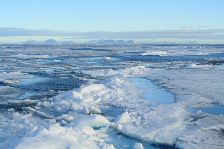
    In recent years, scientists have shown that detecting changes in navigation signals from GPS and Galileo after they bounce off Earth’s surface (GNSS reflectometry, or GNSS-R) can deliver valuable information on sea ice. Now research drawing on data from Spire Global has enabled the generation of Arctic-wide sea ice maps, marking a major step forward for the emerging technique.

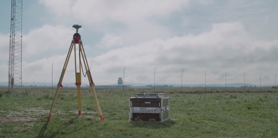
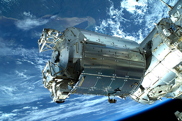
    Spire Global‘s sea ice freeboard maps use data captured by Spire’s GNSS-reflectometry multipurpose listening constellation.

    The research — enabled by the Third Party Missions (TPM) programme of the European Space Agency (ESA) — suggests that harnessing reflected navigation signals could become an important complement to established ice-monitoring altimetry missions.

    The study leveraged Spire’s GNSS-R data to retrieve sea ice freeboard measurements across an entire winter season. The results show strong alignment with established altimetry datasets, including the ESA’s CryoSat mission, validating the complementary role of commercial satellite data alongside government missions.

    Arctic-wide sea ice freeboard map for January 2024
Arctic-wide sea ice freeboard map for January 2024. (Credit: ESA)
    Arctic-wide sea ice freeboard map for January 2024. (Credit: ESA)

    The study was led by Felix Müller at the Technical University of Munich (DGFI-TUM) and Robert Ricker at the Norwegian Research Centre, experts in GNSS-R.

    “The primary purpose of signals emitted from GNSS is to fix the location of a device at any point on Earth,” Müller explained. “However, when these signals bounce off Earth’s surface, their properties change. By analyzing these changes, we can infer information about the characteristics of Earth’s surface.”

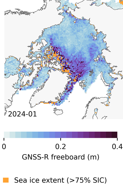
    “Previous research has shown that this technique works well experimentally,” Ricker added. “Using the Spire constellation, we aimed to demonstrate whether it would hold up on a larger scale by generating an Arctic-wide map of sea ice freeboard, which is a measure of how far ice protrudes above the waterline.”

    Spire’s GNSS-R constellation

    Spire’s constellation was first used to sample the atmosphere for weather forecasting. Then scientists began exploring other applications. Spire started collecting reflected signals arriving at shallow angles using a technique called grazing-angle GNSS-R. This method is particularly well suited for ice monitoring.

    The research team analyzed data detected over the Arctic Ocean and surrounding seas between October 2023 and July 2024. The data was obtained via the TPM program, through which ESA disseminates data from a range of commercial and institutional partners on a free basis for research and development purposes.

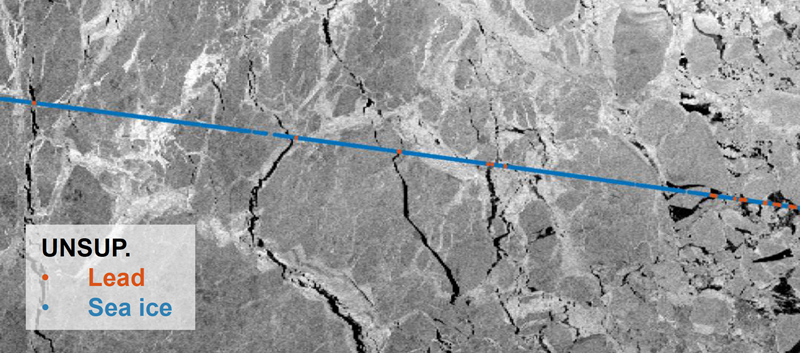
    The team focused on one of the most critical challenges in sea ice altimetry: reliably identifying narrow openings in the ice pack, known as leads. These openings are reference points for determining sea surface height and, ultimately, sea ice freeboard.

    In turn, sea ice freeboard can be used to infer sea ice thickness — an essential parameter for tracking climate change, estimating sea level, and modeling ocean and weather patterns.

    Identifying leads in sea ice with GNSS-R data. (Credit" ESA)
    Identifying leads in sea ice with GNSS-R data. (Credit: ESA)

    Classifying surface properties

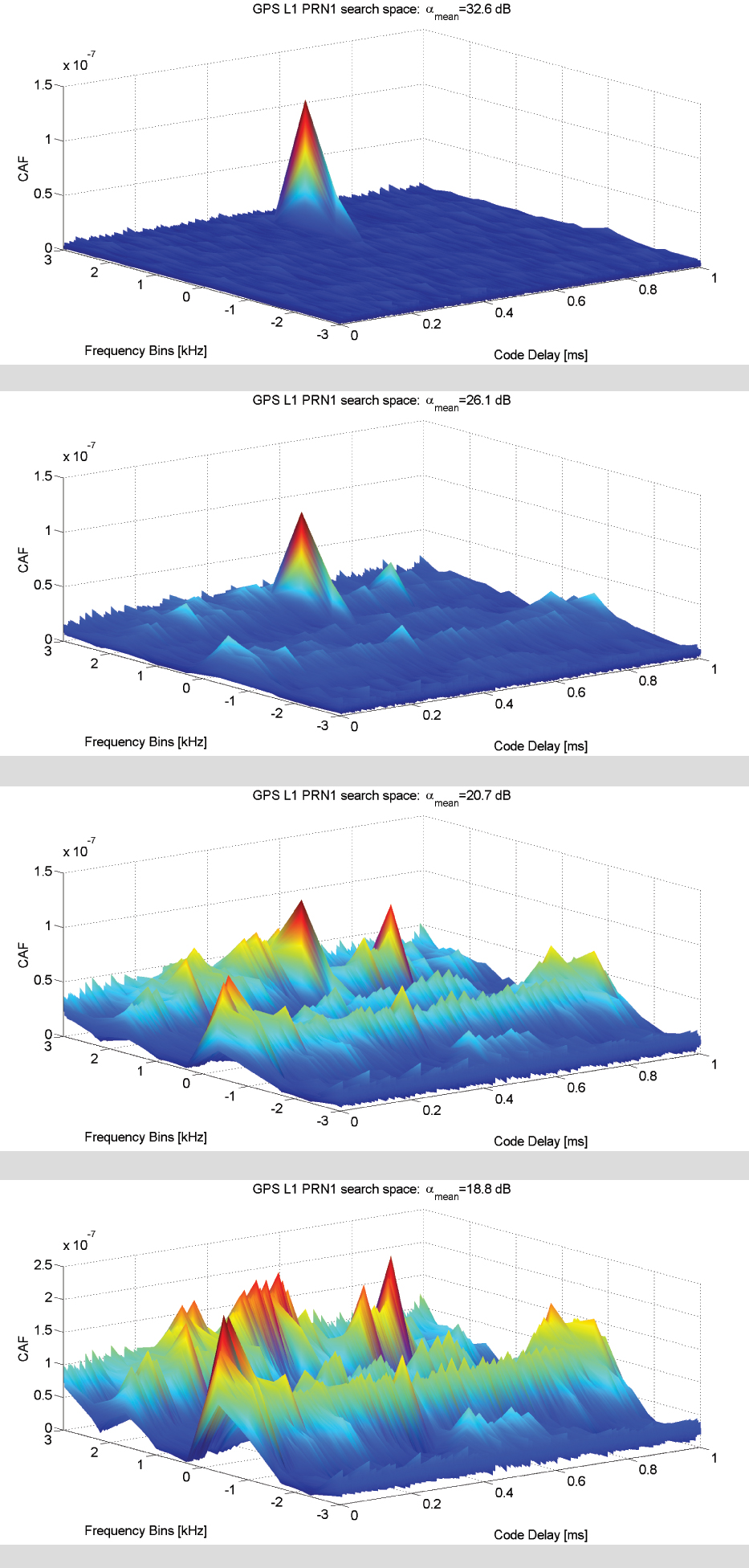
    “In the initial phase of the project, we used two complementary methods to identify surface properties based on GNSS-R data, with the aim of identifying leads,” Müller said.

    The first — known as the adaptive threshold technique — involved measuring the power of the reflected navigation signal to classify surface type as either water or ice. This method allows rapid processing of the entire GNSS-R dataset, while remaining robust to changes in signal conditions.

    The second method — known as unsupervised clustering — offers a more complex approach to classifying surface conditions. In addition to signal power, it considers multiple other signal features that tease out more nuanced information on surface type, including identifying thin or refrozen ice.

    Both methods were compared with co-located CryoSat surface-type classifications and Sentinel-1 imagery, confirming that the GNSS-R classifications were largely comparable against conventional satellite products.

    Mapping sea ice freeboard

    “Building on this classification work, we then took the research to the next step by producing Arctic-wide sea ice freeboard maps from GNSS-R data,” Ricker said.

    The team corrected ice surface height measurements generated from GNSS-R data for tidal variations, sea surface height, and atmospheric delays, which is standard practice in altimetry. A refined algorithm then identified where leads in the ice were likely to occur, with the lowest points in these areas revealing estimated sea surface height. Sea surface height estimates were then subtracted from ice surface heights to retrieve freeboard. Using this approach, monthly gridded freeboard products were generated for the full winter season.

    The team reported that the GNSS-R datasets showed strong agreement with CryoSat freeboard datasets across much of the Arctic, confirming that GNSS-R can reproduce large-scale patterns previously observed by dedicated altimetry missions. Independent validation against upward-looking sonar measurements in the Beaufort Sea further supported the accuracy of the retrieved freeboard values.

    However, as expected, the GNSS-R estimates became less reliable during spring, when surface melt alters reflection characteristics. This limitation is consistent with earlier GNSS-R and radar altimetry studies and remains an active area of research.

    The contribution of commercial data

    While GNSS signals have long been used for positioning, this research highlights how reflected signal analysis can extend their value into large-scale Earth observation applications, delivering persistent coverage independent of sunlight or weather conditions, said Theresa Condor, Spire Global CEO.

    “Advances in miniaturization, digital signal processing, and machine learning have fundamentally changed what’s possible in RF sensing,” Condor said. “Commercial constellations can now deliver persistent, high-quality RF data that complements traditional government systems with greater flexibility and cost efficiency.

    “As environmental monitoring requirements intensify, we’re seeing agencies increasingly integrate commercially sourced RF datasets into operational architectures, reflecting the continued maturation of this market and the growing role of commercial infrastructure in government missions.”

    “By producing analysis-ready gridded datasets, this work marks an important milestone in the progress of grazing angle GNSS-R from an experimental method to a reliable technique for mapping Arctic sea ice freeboard at scale,” said Matthieu Talpe, Remote Sensing Product Engineer, Spire Global. “In doing so, it strengthens the case for the grazing angle GNSS-R technique employed by the Spire constellation as a valuable complement to existing ESA and partner missions, helping to close observational gaps in one of Earth’s most rapidly changing regions.”

  • Real-time interference detection by GIDAS makes satnav safer

    Real-time interference detection by GIDAS makes satnav safer

    It is estimated that there are currently the same number of satnav receivers on Earth as there are people. (Image: ESA)
    It is estimated that there are currently the same number of satnav receivers on Earth as there are people. (Image: ESA)

    News from the European Space Agency (ESA)

    A new monitoring system developed through an ESA-backed project works like a bodyguard for satellite navigation in use at strategic or safety-critical sites. Known as GIDAS, the scalable system immediately detects, identifies and pinpoints satnav interference sources in its vicinity.

    It is estimated that there are currently the same number of satnav receivers on Earth as there are people. Positioning, navigation and timing signals from space-based constellations such as Galileo and GPS form an invisible, essential infrastructure, underpinning numerous modern aspects of modern life: communications, power and transportation.

    Satellite navigation helps guide a growing number of aircraft, boats, trains and autonomous vehicles. Meanwhile satnav-based time stamps authentic multi-billion euro financial transactions, and coordinate the synchronised running of power grids. Satellite navigation is always on, available everywhere on Earth, so it is easy to take its availability for granted. But as crucial as these signals from space are, they are also vulnerable to ground-based interference.

    “It’s simply a matter of output power,” said Andreas Lesch of Austria-based OHB Digital Solutions. “A navigation signal on the ground is equivalent to the light from a 60-watt lamp aboard a satellite, some 23,222 km away in space in the case of Galileo. So these faint signals can be jammed by more powerful local radio signals, either accidentally or deliberately, or even misleading fake navigation signals, known as spoofing.”

    “Our new GNSS Interference Detection and Analysis System, GIDAS, is designed to safeguard critical infrastructure against jamming or spoofing, by performing continuous monitoring of key signal bands. By doing so, GIDAS can raise the alarm in real time, identify the type of interference then pinpoint the location of these dangerous portable devices causing the interference so the authorities can take immediate remedial action.”

    GIDAS can provide interference detection and directionality with a single reporting station, although a minimum of three stations are required for pinpointing interference sources, linked to an overall monitoring center. Monitoring centers can also be connected together, making the GIDAS system easily scalable, from safeguarding an individual harbour, airport or system critical site up to an entire city or region.

    GIDAS can provide interference detection and directionality with a single reporting station, although a minimum of three stations are required for pinpointing interference sources, linked to an overall monitoring center. (Photo: ESA)
    GIDAS can provide interference detection and directionality with a single reporting station, although a minimum of three stations are required for pinpointing interference sources, linked to an overall monitoring center. (Photo: ESA)

    “People are only now catching up to the seriousness of this problem,” adds Andreas. “Surveys of the highest-density parts of Europe surveys report around three to four jammers hourly.

    “These small devices are technically illegal but are easily available online for a few hundred euros or less, often marketed as personal privacy devices. Jammers are sold as having a range of only a few metres, but can turn out to have a practical range of dozens of metres or more — leading to unintentionally widespread interference, like the famous jammer-equipped U.S. truck driver who shut down Newark Airport navigation systems whenever he drove past.

    “Spoofing is more serious still, with a strong criminal element, where false satellite navigation signals replace real ones, to mislead receivers about their position, employed in the past to down put drones or divert boats.

    “Working in this field for eight to nine years, we have seen a strong growth in interference, even as GNSS becomes ever more crucial. With our passion for GNSS and signal processing, we decided to something practical to combat this development, delivering rapid detection, classification and localisation of interference to our customers.”

    GIDAS was developed by OHB Digital Solutions and Joanneum University through ESA’s Navigation Innovation and Support Programme (NAVISP), working with European industry and academia to develop innovative navigation technology.

    “The company initiated the project through NAVISP’s second element, focused on strengthening European competitiveness in the navigation arena, proceeding on a co-funded basis,” said engineer Thomas Burger, overseeing GIDAS project for ESA. “The plan was to enable a commercially attractive business to get started, and I’m happy to say we made it.”

    “Considering the budget, the project had a wide scope, including the development of a multi-constellation GNSS receiver with all processing stages, an extended digital front end for jamming and spoofing detection, processing blocks transferred to a parallel processor based on a customised fully programmable gate array.

    “And that was only one ingredient of the overall GIDAS system, also including the actual interference detection machinery, the interference locating subsystem, and all the communication, database, and graphical user interface elements needed to create a distributed, human-usable system — which is able to go on working autonomously, only asking for human involvement when events are detected.”

    Now that its two-year NAVISP project has concluded, GIDAS is now being rolled out to several Europe-based governmental and private sector customers.

  • Roll over, Eindhoven. And tell tectonics to move.

    Roll over, Eindhoven. And tell tectonics to move.

    A free lesson for those in charge of critical infrastructure systems such as the power grid, communications, financial markets, emergency services, and industrial control.

    Many of these systems have functioned smoothly and efficiently for years, thanks to the precise timing provided by GPS receivers. That could change, suddenly and without warning, if predictive and preventative steps are not taken.

    The GPS receivers somewhere near the hearts of these critical systems, if not thoroughly vetted, tested and checked for up-to-dateness, could constitute a vulnerability — a vulnerability that would be catastrophically exposed on April 6, 2019. In 6 months’ time.

    Image: Orolia
    Image: Orolia

    The GPS constellation transmits the proper date and time to all receivers, worldwide, by supplying the current week and the current number of seconds into the week. This enables the receiver to translate the date and time into a more typical format: day, month, year, and time of day. Infrastructure systems use the precise timing to synchronize many complex operations across their respective networks. Critically, the field that contains the week number is a 10-bit binary number. This limits the range of the week number to 0 – 1023, or 1024 total weeks.

    GPS week zero started January 6, 1980. The 1,024 weeks counter ran out and rolled over on August 21, 1999. The week counter then reset to zero, and it has been recounting ever since. The next time the counter will reach week 1,023 and roll over to zero is on April 6, 2019.

    If the GPS receiver is new or has received firmware updates, it can accommodate and adjust for this change. But do you know for sure? Only if you test. Otherwise, your critical systems may go into a time warp, 19.7 years out of date. Visualize that discrepancy rippling outward from the core component of a critical timing system throughout your infrastructure. Or, simply not working at all.

    It is incumbent upon all managers to verify that such an issue will not occur — well before its possibility arises. At a minimum, experts recommend consulting your receiver manufacturer to confirm that the issue has been fully tested and will not occur. Many manufacturers have already issued compliance statements, and are expected to continue doing so over the next year, up until the event occurs.

    To be sure that your system will not experience any failures related to this issue, it is possible to test for this event using a GPS/GNSS simulator. The requirements for the simulator are straightforward. The basic yet key information necessary to undertake such testing will be communicated in a free webinar on Thursday, November 15.

    The panel of expert speakers includes Lisa Perdue, product manager and applications engineer, Orolia; Stefania Römisch, leader, the Atomic Standards Group at the National Institute of Standards and Technology; and Dana Goward, president, Resilient Navigation and Timing Foundation.

    You may register for this free webinar here, to attend it live or download it for later viewing at your convenience.

    Here is a useful reference from the last time the rollover occurred, with a mention of the next one.

    Photo: Technical University of Eindhoven
    Photo: Technical University of Eindhoven

    Eindhoven, the Netherlands, is home to the Eindhoven University of Technology, an incubator for technology startups where many scientists active in GPS research and in the direction of the Galileo satellite navigation program have trained.

    Tectonics is the study of plates in the Earth’s crust that move in different directions and speeds. To study plate motion, GPS instruments are anchored firmly in bedrock to measure how it moves, infinitesimally yet measurably, thanks to the nanosecond timing provided by the GPS constellation and interpreted by properly calibrated and updated instruments.

    Roll over, Beethoven.

  • Interference mitigated with CRP and dual-polarized antennas: Free webinar

    Interference mitigated with CRP and dual-polarized antennas: Free webinar

    Two new topic areas and presentations have been added to this Thursday’s free webinar on Signal Interference: Detection and Mitigation.

    The speakers will explore anti-jamming protection with controlled radiation pattern antennas (CRPAs) and with dual-polarized antennas. The latter topic is also the cover story for the February issue, which demonstrated a significant improvement in positioning accuracy and robustness against interference with a dual-polarization approach: a gain in terms of C/N0, particularly for low-elevation angle satellites and valuable in urban environments.

    Kirk-Burnell-novatel
    Headshot: Kirk Burnell

    Kirk Burnell from NovAtel joins the Feb. 2 panel to present “How to deliver assured positioning, navigation and timing in GNSS-compromised environments.”

    He will look at applications that stress the importance of high-reliability PNT. Compromised GNSS signals due to unintentional interference is of great concern, but intentional interference due to jamming is much more insidious.  Anti-jamming protection via controlled reception pattern antenna (CRPA) technology is now available to a wide range of users.  A brief explanation of the technology will be followed by a few use-cases where CRPAs have been deployed in a variety of applications.

    Burnell, Core Cards Product Manager for NovAtel, has worked at the company since 2015.  With an education in survey engineering, Kirk has been working with precision GNSS system designers and integrators in both support and product management capacities for more than 20 years.

    Matteo Sgammini
    Headshot: Matteo Sgammini

    Matteo Sgammini  of the German Aerospace Center (DLR) will talk about work with dual-polarized antennas: the principles of operation of such an antenna array and how one performed in real-world jamming and non-jamming scenarios. This ION GNSS+ 2016 presentation became the cover story for GPS World’s February issue.

    Innovation editor Richard Langley writes in his introduction to the February column, “All GNSS satellites transmit RHCP [right-hand circularly polarized] signals and therefore most GNSS receiving antennas are designed for such signals. However, a funny thing can happen to a satellite signal on the way to a receiving antenna. If the signal bounces off a nearby structure or the ground or the sea surface, its polarization is modified and it will become LHCP [left-hand circularly polarized] or a combination of the two polarizations.

    “A primarily LHCP antenna can capture a significant portion of the energy in such a RHCP signal and could provide a strong response to a reflected signal when the line-of-sight signal is missing or very weak. So, there could be a benefit in having a dual-polarized antenna to improve positioning capability in marginal situations. Furthermore, jamming signals can be of arbitrary polarization and a dual-polarized antenna array with beamforming capability could better separate and mitigate such interference.”

    February cover story.
    February cover story. Photo: GNSS

    Researchers at the DLR equipped a GNSS receiver with a diversely polarized antenna array to combine signal processing in the spatial and in the polarization domain. Tests show a significant improvement in receiver robustness against interference compared with the general single-polarization case.

    The carrier-to-noise-density ratios of the line-of-sight components are improved since the receiver can use the power present on the left-hand circularly polarized channels, particularly for satellites with low elevation. Interference mitigation improves due to the possibility of filtering in the polarization domain and the additional number of available degrees of freedom.

    Sgammini received a Masters degree in electrical engineering from the University of Perugia, Italy and now works at the Institute of Communications and Navigation, DLR.  He is currently pursuing a Ph.D. in electrical engineering with research interests in interference mitigation techniques for GNSS. His research activity includes adaptive filtering, array signal processing and estimation theory for GNSS.

    Sign up for  this Thursday’s free webinar here.

    Webinar Summary:

    As the number of GNSS signals being tracked increases, so does the potential for interference to dismiss the performance gains of using those additional signals.

    To maximize performance and efficiency, prepared PNT users need their equipment to be able to detect when interference is present and mitigate it.

    Developers, integrators and users need mitigation tools to protect and preserve GNSS measurement quality, maintaining high-quality multi-frequency multi-constellation positioning performance, even in challenging RF environments. This is essential particularly on the integration journey, especially during prototyping and when encountering unforeseen interference events in field testing, in order to produce fully successful integrated products.

    The one-hour webinar also will include a follow-up Q&A session with the speakers. Burnell and Sgammini join Patrick Casiano of NovAtel and Rick Hamilton of CGSIC on the speaker panel. Casiano will present an Interference Toolkit that measures RF spectrum levels and allows the user to apply mitigation tools to protect and preserve GNSS measurement quality. Hamilton will explain the proliferation of jammers, aspects of illegal use, coordinated government response to interference events, and regulations to prohibit manufacture, import, export, sale and use of jammers.

  • GNSS spoofing will attain virus status, warns expert

    Figure 6. Performance of a typical spoofed case with live data: spoofing detection statistic, threshold, and related probability density functions.

    As manufacturers convert machines and appliances into remotely controllable objects (the Internet of Things), the potential for spoofing expands, perhaps exponentially. Hackers could interfere with the data supplied to autonomous cars or tracks, remotely forcing them to crash.

    Although the dangers of GPS spoofing have been pointedly discussed in may technical papers and articles in GPS World since the early 2000s, manufacturers have not devoted much attention to them because there weren’t many devices making use of location-based technologies, according to associate professor Dinesh Manandhar of the University of Tokyo.

    With the proliferation of GPS-capable smartphones and other networked devices, “anyone can become a target of the attack,”  Manandhar told the Japan Times in a recent interview.

    “Too many things today use GPS as a reliable source of location information,” Manandhar said.  “People trust the location information from GPS satellites like God. When PCs became common for many people, the sudden outbreak of computer viruses became an issue around the world, and anti-virus software become an essential tool for everyone to protect their data,” he added. “The same thing is now happening around GPS. We need a system to fight back against the risk.”

    Manandhar cited some possible examples of spoofing, both by consumers — “You can falsify your smartphone’s information and make it look like you are going back and forth between Tokyo and Hawaii within just three minutes,”  and by sophisticated criminals. “Let’s say I were a top manager of a major bank. I could access all the information while sitting at my desk, but I wouldn’t be able to access it from the room next to it. But people could get access to such information if they disguised the location information received by computer.”

    Manandhar and many other researchers around the world are developing and testing anti-spoofing techniques, but it is a long step from demonstrated results to integration into products reaching market. “The products we are designing today are ones that we will use five years later. So we must assume the possible risks and prepare for the threats that might jeopardize our society in the future.”

    Manandhar co-authored the article “Opening Up Indoors: Japan’s Indoor Messaging System, IMES” in the May 2011 issue of GPS World. The graphic heading this news story is drawn from “GNSS Spoofing Detection: Correlating Carrier Phase with Rapid Antenna Motion,” the Innovation column in the June 2013 issue.

  • ESA Aims to Map Sea Surfaces with GNSS Radio Occultation

    ESA Aims to Map Sea Surfaces with GNSS Radio Occultation

    The International Space Station. (Photo: ESA)
    The International Space Station. (Photo: ESA)

    Feature from the European Space Agency

    A new concept that involves mounting an instrument on the International Space Station and taking advantage of signals from navigation satellites could provide measurements of sea-surface height and information about features related to ocean currents, benefiting science and ocean forecasting.

    We have all seen the beautiful photographs of our planet taken by astronauts, but orbiting Earth 16 times a day just 400 km above, the Space Station also offers a platform from which to measure certain variables related to climate change.

    So, in 2011 the European Space Agency (ESA) called for proposals to explore how the Space Station could be used to make scientifically valid observations of Earth. After reviewing and assessing numerous proposals, the result is to further develop the GEROS-ISS mission concept.

    Jason Hatton, GEROS-ISS project coordinator, said, “The concept is still going through feasibility studies, but the aim is to launch the experiment towards the end of 2019. It would be carried to the Space Station on a cargo vehicle and installed on ESA’s Columbus space laboratory using a robotic arm, after which GEROS-ISS would run for at least a year.”

    GEROS-ISS stands for GNSS reflectometry, radio occultation and scatterometry on board the ISS. GPS and Galileo satellites send a continual stream of microwave signals to Earth for navigation purposes, but these signals also bounce off the surface and back into space.

    The idea is to install an instrument with an antenna on the Space Station that would capture signals directly from these satellites as well as signals that are reflected or scattered from Earth. This process could be used to calculate the height of the sea surface, and to measure waves — or “roughness” — that can then be used to work out the speed of surface winds.

    Sea-surface_height_cm-W
    Variations in sea-surface height (cm) obtained by merging multiple altimeter measurements. GEROS-ISS would be able to observe this variability so that maps covering latitudes 51° N to 51° S can be produced every four days. (Photo: ESA)

    GEROS-ISS is primarily an experiment to demonstrate new ways of observing Earth. However, if taken beyond the testing phase this new approach would complement measurements from satellites carrying altimeters such as CryoSat and Sentinel-3, and satellites carrying wind scatterometers such as MetOp.

    Importantly, it is the first concept to assess the potential of spaceborne GNSS reflectometry to determine and map ocean height at scales of 10–100 km or longer in less than four days. Current satellite altimeters, in comparison, offer global maps at scales of around 80 km, which are produced from multiple datasets every 10 days.

    A system based on GEROS-ISS would, therefore, complement existing satellite systems, helping to map ocean variability at finer spatial and temporal scales over a range of seas in tropical and temperate regions. It would also refine our understanding of how well the concept would work for measuring the roughness of the ocean surface.

    In this respect, the development of GEROS-ISS benefits from experience gained with the UK’s TechDemoSat-1, which also measures ocean-surface roughness using a similar technique. It is also hoped that NASA’s upcoming CYGNSS constellation of mini satellites will help pave the way for GEROS-ISS.

    In addition, GEROS-ISS uses a technique called radio occultation whereby the antenna receives signals that are refracted as they pass through the atmosphere. This can be used to generate vertical profiles of atmospheric humidity, pressure and temperature, as does the GRAS instrument on the MetOp satellites, for example.

    Europe’s Columbus space laboratory, photographed by ESA astronaut Luca Parmitano during his spacewalk on July 9, 2013.
    GEROS-ISS will be installed on the upper balcony of ESA’s Columbus space laboratory, which provides mechanical interface plates as well as power, command and data links to the ISS systems. (Photo: ESA, taken by ESA astronaut Luca Parmitano during his spacewalk on July 9, 2013. )

    “It is very flexible, combining different mission concepts and applications in one: GNSS-reflectometry to determine sea-surface height, scatterometry to measure sea-surface roughness and radio occultation for atmospheric studies,” said Jens Wickert who leads the science team that proposed GEROS-ISS.

    ESA engineer Manuel Martin-Neira noted, “The original concept actually goes back over 20 years and has matured considerably through numerous studies and campaigns, however, it has never been duly tested from space.”

    “Being able to use the International Space Station in this way means that we can quickly validate innovative observing techniques without having to build an entire satellite, and we expect this to lead to new opportunities for science,” added Michael Kern, ESA’s GEROS-ISS mission scientist.

    The GEROS-ISS feasibility studies are being carried out through ESA’s General Studies Programme.


    Editor’s Note: GPS World discussed the use of GPS for radio occultation in its March 1994 Innovation column, “Monitoring the Earth’s Atmosphere with GPS,” by Rob Kursinski.

  • Project Counters Ionospheric Disturbance for GNSS

    The monitoring station in Brazil uses a Septentrio PolaRxS receiver to monitor the ionosphere, a Septentrio AsteRx3 to perform tests static and kinematic tests, and three RTK Altus APS3 receivers (one as a base station and two as rovers.)
    The monitoring station in Brazil uses a Septentrio PolaRxS receiver to monitor the ionosphere, a Septentrio AsteRx3 to perform tests static and kinematic tests, and three RTK Altus APS3 receivers (one as a base station and two as rovers.)

    After 27 months of intensive research, a project team funded under the European Union’s 7th Framework Programme has come up with a solution to counter the problem of ionospheric disturbance affecting GNSS signals.

    The CALIBRA project recently showcased a commercially applicable approach to mitigate the phenomenon’s impact on high-accuracy GNSS positioning techniques. In  two demonstrations, the project’s newly developed algorithm was successfully tested in actual precision agriculture and offshore operations.

    Solar flares can cause ionospheric disturbance, a sudden increase in radio-wave absorption that often delays the propagation of signals and ultimately affects positioning. The problem has kept researchers busy for years.

    The CALIBRA project team has been participating in this global research effort by focusing on Brazil, which is one of the most exposed regions due to its proximity to the magnetic equator. Add to this that the sun is at its peak of activity since it entered its new 11-year cycle in 2010.

    The project achieved three main milestones. First, the team confirmed that ionospheric scintillation and variations in total electron content (TEC) had a direct impact on the functioning of high accuracy GNSS techniques, such as Precise Point positioning (PPP) and real-time kinematic (RTK) positioning. Then a suitable metric was established to characterize these ionospheric disturbances. Finally, the project produced a short-term empirical model for forecasting TEC and scintillation. A regional TEC map was developed which proved advantageous for use in Brazil and, to counter scintillation, a number of approaches for the mitigation of this phenomenon were proposed and their benefit demonstrated.

    The project exploited the CIGALA-CALIBRA network and database — a network of ionospheric scintillation monitor receivers with a web interface (the ISMR Query tool), which collects more than 10 million observations on GPS, GLONASS, Galileo, BeiDou and other global navigation systems every day. Since it was launched in December 2014, this data has helped assist users from more than 20 countries because of the software’s visualization and mining techniques.

    In light of this success, CALIBRA partners INGV (Istitute Nazionale di Geofisica e Vulcanologia) filed a patent for their forecasting model, and a new spin-off company — SpacEarth Technology — was set up. SpacEarth’s main purpose is to secure the software’s commercialization in relevant applications and services, while also improving and adapting it to evolving market needs.

    The project’s results promise to considerably reduce downtime and financial losses caused by ionospheric disturbance in Brazil and other regions of the world. Learn more about the project here.

    Another ionospheric mitigation project was presented at the European Navigation Conference earlier this month.

  • Tallysman GNSS Antennas Optimized for Multi-Constellation Systems

    Tallysman’s compact GNSS TW1721 Dual Feed embedded antenna with Accutenna technology.
    Tallysman’s compact GNSS TW1721 dual-feed embedded antenna with Accutenna technology.

    Tallysman, a provider of high-performance, high-quality RF and GNSS components, has announced that its range of antennas featuring proprietary Accutenna technology is optimized for today’s multi-constellation satellite systems, including Europe’s Galileo, China’s next-generation BeiDou, GPS, GLONASS and India’s IRNSS.

    Tallysman’s compact GNSS antenna range with Accutenna technology is future-proof: GNSS is changing, and an increasing number of receivers are capable of accessing multiple constellations — GPS, GLONASS, Galileo, BeiDou — but to provide the high precision these new generation of satellites enable also requires new antenna technology.

    Tallysman’s proprietary Accutenna dual-feed patch technology used in the company’s wide range of GNSS antennas provides circular response over the entire antenna bandwidth, yielding superior multi-path signal rejection-low axial ratios, tight phase center variation (PCV), and a linear phase response. Single-feed patch antennas, by contrast, only provide a circular response at a single frequency and exhibit poor multipath signal rejection when receiving signals from two or more constellations. A pre-filtering option is available that gives additional protection from near out-of-band signals if required.

    “Today’s wideband GNSS signals require a pure right-hand-circular response over a much wider bandwidth,” said Gyles Panther, president of Tallysman.  “An inadequate phase response results in poor cross polarization suppression, which simply cannot be overcome in the GNSS receiver chip, regardless of its capabilities. Moreover, multipath interference can be expected, even in normal reception situations. Accutenna technology is a cost-effective way to ameliorate this and is particularly beneficial in situations where precision matters.”

    In March, the European Space Agency launched two additional satellites (Galileo 7 and 8). Also in March, the United States launched GPS IIF-9, India launched IRNSS-1D, and China successfully launched its new generation BeiDou-3 M1. The expanding number of satellites will benefit many applications, from next-generation in-car navigation systems to coastguard search and rescue and precision agriculture, Tallysman said.

  • Expert Advice: The Impact of RFI on GNSS Receivers

    Expert Advice: The Impact of RFI on GNSS Receivers

    By Fabio Dovis

    Fabio Dovis
    Fabio Dovis

    When subjected to very strong interference, a GNSS receiver can be totally blinded and stop working. This is often the scope of intentional jammers. However, in a number of cases the presence of interference is severe enough to significantly decrease receiver performance, but not so much as to make the receiver lose its lock on the satellite signals or blind the acquisition of the satellite signals.

    Such intermediate power values turn out to be the most dangerous cases, because sometimes they cannot be detected, but lead to a worsening of the positioning performance. The accuracy of the position solution depends on, among others, the quality of the pseudorange measurements and/or the phase measurements. Thus, when radio-frequency interference (RFI) degrades the pseudorange and phase measurements or induces cycle slips on the phase measurements, the accuracy of the position solution will decrease.

    Impact on the Front End

    The front-end filters the incoming signal, demodulating it to the chosen intermediate frequency before performing the analog-to-digital conversion (ADC).  We must consider the presence in the front end of the adjustable gain control (AGC) between the analog portion of the front end and the ADC. When the GNSS band is interference-free, AGC gain depends almost exclusively on thermal noise, since the received signal power is below that of the thermal noise floor. When in-band interference is present, the AGC will squeeze the incoming signal to match the maximum dynamics of the ADC, causing a reduction of the amplitude of the useful signal, which may be lost. This may typically happen in the presence of some kind of wide-band interference (WBI) spread over a bandwidth larger than the passband of the front-end filter.

    With narrow-band (NBI) or continuous-wave interference (CWI), statistics of the digital signal at the ADC output are also affected. In this case the AGC can still compress the input signal to avoid a stronger saturation, but the following receiver stages will have to deal with a GNSS contribution quantized only on lower levels.

    In the presence of stronger interference, even the other components of the front end (filters and amplifiers) may be led to work outside of their nominal regions, generating nonlinear effects or clipping phenomena (in which the signal amplitude exceeds the hardware’s capability to treat them). In both cases, spurious harmonics are generated and mixed with the useful signal in the front end itself.

    Impact on the Acquisition Stage

    If the interference is not driving the AGC/ADC to full saturation, the acquisition module is still able to perform its task, processing the interfered signal to estimate the code phase and the Doppler shift with respect to the local code. The correlation with the local code can be seen as a spreading operation followed by a filter.

    Figure 1. GPS L1 C/A acquisition search space in (a) an interference-free environment and in the presence of (b) –140 dBW in-band CWI; (c) –135 DBW in-band CWI; (d) –130 dBW in-band DWI.
    Figure 1. GPS L1 C/A acquisition search space in (a) an interference-free environment and in the presence of (b) –140 dBW in-band CWI; (c) –135 DBW in-band CWI; (d) –130 dBW in-band DWI.

    Figure 1 shows  the acquisition search space for different levels of the  interfering power of a CWI from –140 to –130 dBW compared to the interference-free case. The search spaces depicted for the four scenarios are achieved using 1 ms of coherent integration time and three non-coherent accumulations, and the peak-to-noise-floor separation defined as

    is considered as a figure of merit. The value of αmean decreases as the interfering power increases, thus increasing the probability of a false alarm. With the increasing power of the CWI, a modulation effect in the search space floor in the Doppler domain dimension can be observed. Such an effect is mainly determined by the new harmonics components generated by the multiplication between the locally generated carrier and received CWI. Such an effect also depends on how the interfering signal and the useful GNSS signal are combined at the entrance to the acquisition block, which in turn depends on the random variables φ0 and θint.

    In the presence of WBI, a different effect is observed in the acquisition search space. Considering a band-limited Gaussian white noise spread all over the GNSS useful filtered signal components, the effect on the CAF envelop is an increase in the noise floor. This increases the search space noise floor. The presence of additive band-limited noise causes a uniform increase in the noise floor tin the search space that might mask the correct correlation peak and thus fool the acquisition process.

    Impact on the Tracking Stage

    Interference impact on the tracking stage has a direct consequence on the quality of the measured pseudorange. Harmful interfering signals increase the variance of the time-of-arrival (TOA) estimate by the discriminator and modify the shape of the S-curve of the code discriminator, thus creating in some cases a bias in the measurements. 

    Figure 2 depicts outputs of the early-prompt-late correlators. In the presence of in-band CWI and of NBI, the interference is injected 9.3 seconds after the beginning of the tracking stage where the receiver is correctly locked on the received signal. A CWI, shifted 200 kHz with respect to the signal intermediate frequency (in correspondence with a C/A code spectrum line), increases the noise at the correlators outputs and leads to harmonic behavior of the early-prompt-late correlator outputs.

    Figure 2. GPS L1 C/A code tracing error comparison: coherent and non-coherent early-late processing (CELP and NELP).
    Figure 2. GPS L1 C/A code tracing error comparison: coherent and non-coherent early-late processing (CELP and NELP).

    NBI increases the variance of the correlators’ outputs; this directly increases the pseudorange error and the noise on the receiver phase measurements. Additive band-limited noise leads to an overall increase in the carrier phase discriminator output variance over the 3σ threshold, which for a PLL two-quadrant arctangent discriminator is 45 degrees. When in presence of strong CWI, a sudden jump of the phase discriminator output is detected as soon as the CWI is injected onto the received signal.

    Impact on the Estimated Signal-to-Noise Ratio

    Sticking to the definition of C/N0 as the ratio between the received power and the power spectral density due to thermal noise at the input of the receiver, the presence of interference should not change the value, since the thermal noise is not increasing. However, the C/N0 value provided by the receivers is estimated on the basis of the correlator outputs at the tracking stage. For this reason the estimation is affected by the presence of the additional (nonthermal) noise generated by the interference. The variation of the C/N0 can also be used as observable for interference (or other threats) detection.


    Condensed from Chapter 2 of GNSS Interference Threat and Countermeasures, edited by Fabio Dovis, published by Artech House. This article omits many figures, equations and technical discussions given in book.

    Chapters: The Interference Threat; Classification of Interfering Sources and Analysis of the Effects on GNSS Receivers; The Spoofing Menace; Analytical Assessment of Interference on GNSS Signals; Interference Detection Strategies; Classical Digital Signal Processing Countermeasures to Interference in GNSS; Interference Mitigation Based on Transformed Domain Techniques; Antispoofing Techniques for GNSS. The book is intended for members of the engineering/scientific community with pre-existing knowledge of satellite navigation principles and GNSS.


    FabIo Dovis holds a Ph.D. in elecronics and communications engineering from Politecnico di Torino, Italy, where he is an associate professor.

  • Russian Company Credo-Dialogue Releases GNSS Software

    The Russian company Credo-Dialogue has released Credo GNSS 1.0, a GNSS processing software.

    Credo GNSS 1.0 is designed for processing of satellite geodetic measurements in differential mode. In this mode, the simultaneous operation of two or more receivers forms the baseline.

    The input can use the following types of data:

    • satellite geodetic measurements and ephemeris format RINEX (2.0-3.2);
    • satellite geodetic measurements and ephemeris formats satellite geodetic receivers (in accordance with the import module);
    • import point coordinates from text files in any format, user-configurable;
    • precise ephemeris (can be downloaded automatically to the time span of the project); and
    • raster image formats BMP, GIF, TIFF (GeoTIFF), JPEG, JPEG2000, PNG, CRF, ECW and RSW.

    Also in the program, users can view images from web services such as Google Maps, Bing and Express Kosmosnimki.

    Credo GNSS supports a variety of coordinate systems, including Transverse Mercator, Mercator, PseudoMercator, Lambert Conformal Conic and Orthographic.

    To learn more about the software, click here or view the video below.

    https://www.youtube.com/watch?v=zRmTB4GEhak

  • New Version of GAPS PPP Software Available

    A new version of the online GAPS precise point positioning software is now available. GAPS — GPS Analysis and Positioning Software — is offered by the University of New Brunswick Geodesy and Geomatics Engineering Department.

    The latest release provides capabilities for handling GPS data files in both RINEX 2 and 3 formats, whether Hatanaka-compressed or not, along with a number of receiver raw file formats. Also, additional input and output data-quality verification is now performed.

    More information on the release can be found here, and the new version is available here.

  • Langley’s Ionosphere Research Focus of CBC Report

    Langley’s Ionosphere Research Focus of CBC Report

    Richard Langley describes the ionosphere study to CBC News reporter Shawn Fowler.
    Richard Langley describes the ionosphere study to CBC News reporter Shane Fowler. (Screen capture from CBC News video)

    CBC News interviewed GPS World Innovation Editor Richard Langley about his ionosphere interference research project with NASA, reported on earlier this week.

    Langley, a professor at the University of New Brunswick, is working with the Jet Propulsion Laboratory in California to better understand how the ionosphere is disturbed by a variety of phenomena including solar outbursts and other natural hazards such as tsunamis. They are using the signals from GPS satellites to probe the ionosphere with the signals being picked up by receivers both on the ground and in low-Earth-orbiting satellites. The research could help find ways to mitigate ionospheric interference to GPS signals themselves as well as to other types of radio communications.

    “GPS satellites are much higher than the ionosphere,” Langley told CBC News reporter Shane Fowler. “So the signals from the satellites have to come down through the ionosphere to receivers on or near the Earth’s surface. And as they come down through the ionosphere they get a little distorted. When you see auroras in the sky, that’s when you can tell the ionosphere is a bit disturbed. The average consumer may not notice these variances, but high-precision applications, like for scientific applications, we actually always see the effect of the ionosphere.”

    Screen capture from CBC news video.
    Screen capture from CBC news video.

    The research could also help develop early-detection systems for tsunamis. “The energy from that water displacement actually propagates up all the way into the atmosphere, all the way to the ionosphere,” Langley told CBC. “It basically moves around the electrons up there and GPS signals coming down from the satellites, through the ionosphere, pick up those small variations. It has the potential to save a lot of lives.”

    Solar flares can also affect GPS signals. The Carrington Event, a solar storm in 1859, knocked out some of Earth’s telegraph systems. “The effect on the Earth’s magnetic field was so strong that currents were set up,” Langley told the CBC. “Those currents were so strong that telegraphs could run without batteries. There was enough current from this disturbance that it could run the telegraphs. And in some cases there was too much and rumour has it started small fires. Luckily we haven’t had one of those again; it seems to be a one-in-100-year, or a one-in-a-200-year, event.”