Tag: situational awareness

  • GeoQ: Robust homeland security tools for first responders

    Art Kalinski, GISP
    Art Kalinski, GISP

    When I was the GIS manager of the Atlanta Regional Commission, the most rewarding and important work we did was geospatial support for our first responders. The culmination of this effort was creation of a portable GIS that we could set up in the field on short notice anywhere in the region to provide situational awareness for first responders.

    The system consisted of two laptops, external hard drives, a HP “E”-size plotter, foam-board laminator and an LCD projector — all housed in a portable tent. We used ArcInfo and ArcView to build and overlay vector data on ortho/oblique aerial imagery to aid visualization.

    We found that police and firefighters especially liked our large laminated plots of imagery overlaid with street data, because the aerial images were easy to understand and the GIS data provided needed location references. The hard-copy plots required no computer and could be marked up with grease pencils.

    ARCUASI-W

    ARC_UASI-W

    Helping in our small way, we provided the same kind of large plots of New Orleans to the Louisiana National Guard days after Hurricane Katrina hit. We later learned that the plots were used by National Guard headquarters to keep track of search-and-rescue efforts by marking up neighborhood blocks with grease pencils and recording search results. They crossed off buildings that had been searched and recorded urban rescue information such as who did the search, and the date and number of live or deceased bodies found. The hard-copy plots were a low-tech embodiment of higher tech GIS data and imagery.

    Firefighter-W

    Nine years later, the National Geospatial-Intelligence Agency (NGA) developed a similar but higher tech and more robust system called GeoQ.

    GeoQ: Geographic Work Queueing and Tasking System

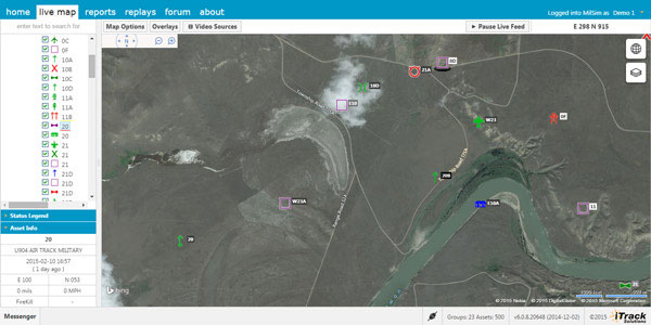
    GeoQ is an open-source geographic tasking and management system that facilitates collection and display of diverse geographic and geographically tagged data across large areas to provide situational awareness for all involved. As needed, the large areas can be broken down into small grid squares and assigned to teams or team members for detailed analysis or tasking.

    The system is designed to be very transparent so all involved can view the workflow and assist as needed, while avoiding duplication of effort. This NGA video is a well done and rapid overview of GeoQ.

    GeoQ software was developed by NGA and the MITRE Corporation to leverage NGA tools and data to the benefit of Homeland Security personnel. In 2013, the leadership at NGA made a gutsy decision to share some of their unclassified geospatial tools with the nation’s first responders through GitHub, an open-source software developers’ online collaboration environment. With more than 2 million participating programmers, GitHub hosts more software source code than any other single service in the world.

    GeoQ was the first NGA product shared through GitHub, and was in keeping with a change in philosophy at NGA to take advantage of feedback and improvements generated by the huge and diverse talent pool available through GitHub. NGA was the first intelligence agency to share some of its work in this open-source environment, and the results have been extremely beneficial to all involved.

    The Huntsville Connection

    With more than 70 geospatial firms and agencies, Huntsville, Ala., has always been an early adopter of geospatial technology. Several years ago it was again a Huntsville team that developed a first-ever Google Earth Enterprise-based emergency response system called Virtual Alabama. The system was so effective that eight other states adopted the model. Work was underway to build a national version when Google announced the phasing out of Google Earth Enterprise. We now know that Google was not motivated to build authoritative geospatial systems, but was focused on building products and services that attracted customers so it could accomplish its primary business of selling advertising.

    Fortunately, the work of the Virtual Alabama team was not wasted. Team members became experts regarding first-responder operations and their unique situational awareness requirements. They learned that first responders needed much more than just a GIS. The best analogy I can think of is that one could use PowerPoint as a word processor, but that wouldn’t be a very efficient system. Likewise, MS Word could be used for presentations, but not as elegantly as PowerPoint. The same holds true for rapid dissemination, communication and perception of a common operational picture. Geospatial tools and analysis are part of situational awareness, but the work flow and many components are different, not necessarily spatial and need to be assembled and processed at their own pace.

    The timing was almost perfect, since GeoQ was released as Google Earth Enterprise was being phased out. Huntsville again seized the opportunity to build on its experience, and GEOHuntsville became a prime GeoQ testbed. I recently met with Chris Johnson, one of the early Virtual Alabama leaders and president of A Visual Edge, Inc., a Huntsville geospatial firm. She demonstrated GeoQ and Huntsville’s role in advancing the technology.

    GitHub has a very thorough description of GeoHuntsville, a non-profit 501c6, and its role with NGA to test and share lessons learned through a “Blueprint for Safety” pilot project involving other cities to improve rapid disaster response. The sharing of lessons learned, code sets and documentation through the multi-city collaboration is called “Exemplar City.”

    Another aspect of the Blueprint for Safety is support of rapid sensor deployment in support of first responders through common standards. Sort of a “plug-and-play” for complex devices. (See the GeoQ projects page and the OpenSensorHub.)

    There is quite an extensive collection of material on GitHub regarding GeoQ and other NGA, projects including support of FEMA and GeoQ technical specifications. NGA doesn’t directly support these efforts, with legal language such as “NGA assumes no responsibility for the use of the software by any parties, and makes no guarantees, expressed or implied, about the software quality, reliability, or any other characteristic.” Still, NGA is behind the creation of the software and is working on other tools and support that will expand the capabilities. Participation of both GeoHuntsville and the Federal Emergency Management Agency (FEMA) bodes well for future use, since I don’t envision the same situation we ran into with Google and Virtual Alabama/USA.

    Update on What3Words

    In February, I wrote about what3words. The simple what3words system is now available as a locator, accessible via the Esri ArcGIS platform.

  • iTrack Solutions Provides Web-Based Fleet Management Software

    livemap_aerial_itrack
    Photo: Integrated Tracking Solutions

    Integrated Tracking (iTrack) Solutions Loki Gen 6 is a web-based mapping software derived from a series of other Loki software products focused on asset tracking for large fleets of vehicles.

    The maps are provided by Bing, but custom mapping can also be used with the support of Esri ArcGIS REST services and shapefiles.

    iTrack Solutions is based in Calgary, Canada, and provides GPS tracking, mobile data communications and display software. The Loki Gen 6 features are listed below.

    Home
    Home is a configurable dashboard showing plans, schedules, calendars and other details.

    Live View
    Live View shows the live BING map from anywhere in the world, which includes maps, satellite and aerial imagery as well as maps provided by the user. Video streams are supported, and a 3D viewing feature is provided from Cesium. A user can add or draw features on the map to share with other users.

    itrack2 Photo: Integrated Tracking Solutions
    Photo: Integrated Tracking Solutions

    Communication
    With this feature, users can communicate one-to-one or through a chat room, which includes video chat functionality.

    Management
    An administrative user can assign tracking devices to vehicles, assign vehicles to subgroups, assign subgroups to larger groups or drivers to vehicles. An administrator also can set privileges for individual users.

    Access to data
    Users can generate and view a replay on the fly as well as generate reports for vehicle tracking, hours in service, mileage, stop location and speed.

    Observations, Analysis
    The forum feature provides a place group discussion, which becomes part of the Loki database, is searchable and can be linked to reports and replays.

  • KVH Receives $4.3M Order for Military Navigation Systems

    KVH Receives $4.3M Order for Military Navigation Systems

    The KVH TACNAV II.
    The KVH TACNAV II. Photo: KVH

    KVH Industries, Inc., has received a $4.3 million order for its TACNAV tactical navigation systems from a new customer who is a major defense contractor providing armored vehicles for an international military client. With a short delivery requirement, shipments for this order are expected to be substantially completed in the fourth quarter of 2014.

    “KVH is extremely pleased to be selected by another major defense contractor to provide the tactical navigation solution for their new armored vehicles. Providing precise navigation as well as coordination of vehicles in critical situations is an important tool that helps keep soldiers oriented wherever they operate,” said Dan Conway, executive vice president of KVH’s Guidance and Stabilization group.

    KVH’s TACNAV military vehicle navigation systems provide unjammable precision navigation, heading, and pointing data for vehicle drivers, crews, and commanders. TACNAV can also serve as a heading and position source for situational awareness.

    In October, KVH received a $19 million contract for the delivery of a new fiber optic gyro-based tactical navigation system for use by an international military customer in an armored vehicle application.

    TACNAV systems are in use by the U.S. Army and Marine Corps, as well as many allied customers including Canada, Sweden, Great Britain, France, Germany, Spain, Egypt, Botswana, Australia, New Zealand, Saudi Arabia, Taiwan, Romania, Poland, Turkey, Malaysia, Switzerland, South Korea, Singapore, Brazil, and Italy.

  • KVH Receives $19 Million Order for FOG-Based Navigation Systems

    The TACNAV 3D, by KVH Industries. Photo: KVH Industries
    The TACNAV 3D, by KVH Industries. Photo: KVH Industries

    KVH Industries, Inc., has received a $19 million contract for the delivery of a new fiber optic gyro (FOG)-based tactical navigation system for use by an international military customer in an armored vehicle application. A variant of KVH’s TACNAV FOG product and KVH’s new TACNAV 3D, the system provides continuous high-accuracy position and orientation even when GPS is lost or jammed.

    Work on the contract began in July under a letter contract, and hardware shipments for this order are expected to be made in 2015 and 2016. Program management, engineering services, and out-year support services will be provided as part of this order.

    “KVH’s TACNAV navigation solution is an important tool for U.S. and allied warfighters, providing precision navigation as well as coordination of vehicles in critical situations,” said Dan Conway, executive vice president of KVH’s Guidance and Stabilization group. “The system serves as a crucial resource for navigation and battle management, and even as a backup in GPS-denied environments, keeping soldiers safe and out of harm’s way wherever they travel. This new order reaffirms the value of KVH’s TACNAV products for international militaries, and adds to our backlog for the coming years.”

    All of KVH’s TACNAV military vehicle navigation systems provide unjammable precision navigation, heading, and pointing data for vehicle drivers, crews, and commanders. TACNAV can also serve as a heading and position source for situational awareness. The TACNAV system ordered is a FOG-based navigation and pointing solution, which is designed to ensure precise navigation data regardless of GPS availability as well as automatic “drive and calibrate” capability. It features a compact design, continuous heading and pointing data output, and a flexible architecture that allows it to function as either a standalone navigation module or as the heart of an expanded, multifunctional TACNAV system. The system is designed to integrate with Battle Management Systems (BMS) and is a vital component for effective battlefield management.

    TACNAV systems are currently in use by the U.S. Army and Marine Corps, as well as many allied customers including Canada, Sweden, Great Britain, France, Germany, Spain, Egypt, Botswana, Australia, New Zealand, Saudi Arabia, Taiwan, Romania, Poland, Turkey, Malaysia, Switzerland, South Korea, Singapore, Brazil, and Italy.

  • Everbridge Adds Mobile, GIS Enhancements to Unified Critical Communication Suite

    Everbridge has launched a Summer Release of its Unified Critical Communication Suite with new mobile, GIS, and expanded alerting enhancements that enable Everbridge customers to deliver unified critical communications and situational intelligence within the context of their recipient’s needs, roles, and locations.

    As enterprise mobility, BYOD, and other unified communications drivers continue to converge in an increasingly global, yet unpredictable world, organizations deploy Everbridge’s Unified Critical Communication Suite to respond and collaborate during both emergency and operational incidents, the company said.

    The latest release expands upon the recently launched spring release, offering new features designed to unify multi-modal, critical communications for diverse industries, including corporations, state and local government, healthcare, financial services, and higher education. The summer release includes new updates to Everbridge’s recently unveiled IT Alerting solution — specifically designed for IT Operations teams to improve communications and collaboration during incidents, resolving issues faster, and maximizing IT system uptime.

    Additional upgrades to the summer release include:

    PrecisionGIS: Everbridge’s rich GIS functionality now includes three new map-based targeting capabilities:

    • Geofencing: This new feature enables users to draw simple or multiple complex polygons to define boundaries and control the behavior of addresses located inside or outside the “fence.”
    • Custom Base Maps: Everbridge supports commercial mapping applications, including Google, Bing and ESRI, and now enables organizations to overcome existing gaps with commercial maps by customizing the base map used within the Everbridge suite. The base maps can include the geographical or infrastructure information users need to make more informed decisions when preparing and targeting a message.
    • Point-Address Geo-Coding: Users can now manage and provision all addresses down to the parcel level to ensure the data is accurate and precise enough for critical communications. This enables an advanced level of custom and granular geocoding capabilities beyond what is available via commercial geo-coding applications.

    Rich Text Formatting: The Everbridge suite provides enhanced rich text formatting support for email, enabling users to send the right message to the right contact path. Users can now deliver full-featured, unique messages, including entire web pages without modification, optimized for Phone, SMS, Email, and Push Notification contact paths.

    Mobile Enhancements: New mobile device registration simplifies user access and improves Mobile Member opt-in. New enhancements also include “silent mode” override for Android mobile devices to ensure that critical messages get delivered at all times.

    On-the-Go Alerting: This new partner functionality enables users to create and transmit customized alert messages directly from an iPad application. Users can draw affected areas directly on a map, while sending and receiving notifications through IPAWS communications channels.

    On-Call Scheduling: Everbridge now provides robust on-call scheduling to automate outreach to on-call teams with rotating coverage or complex shift changes. Seamlessly integrated with Everbridge notifications, on-call scheduling eliminates the need for manual call lists and handwritten calendars.

    “The new enhancements to our summer release reflect our continuing commitment to product investment and innovation,” said Imad Mouline, CTO of Everbridge. “Our customers are confronted daily with new challenges and opportunities related to mobility, business continuity, emergency notification, secure messaging, and more. We will continue to evolve our suite to meet these challenges—unifying critical communications across modalities and devices on a global scale.”