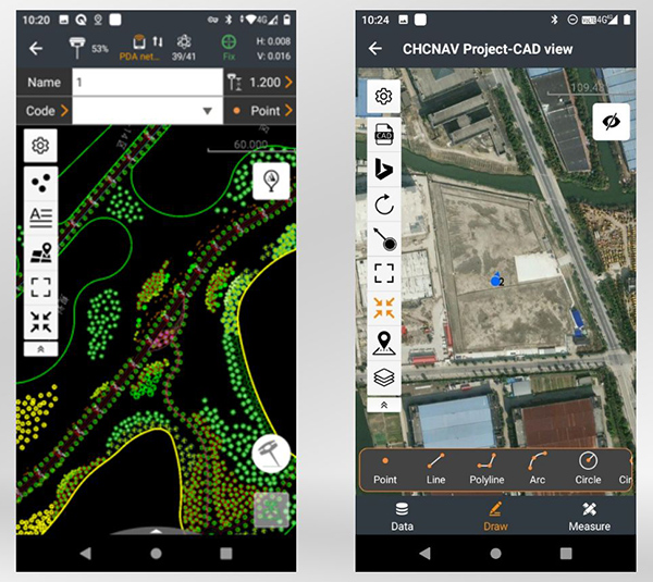
CHC Navigation has released LandStar8, a field surveying and mapping application for Android devices. LandStar8 is designed to be flexible and user-friendly for surveying and mapping tasks.
LandStar8 is versatile, modular and customizable for topographic tasks such as surveying, stake out, cadastral, mapping and geographic information systems (GIS). Building on the legacy of LandStar7, the new LandStar8 provides features such as a refined user interface, streamlined workflows, faster operation, and integrated cloud services.
“With LandStar8, we want to provide our users with unprecedented field experience,” said Rachel Wang, product manager of CHC Navigation’s Surveying and Engineering Division. “LandStar8’s modular design allows users to customize the interface according to their usage habits, making it easier and more efficient for field crews to work.”
Cloud connectivity is built in, for backup, data storage or remote technical support.
LandStar 8 has a simple and intuitive layout with large map windows and sharp graphics. Users can hide features they rarely use and display only those they need.
On LandStar8, users can copy coordinate settings, control and staking points from another handheld controller by scanning a QR code. Projects can be edited and sorted by history and attributes. Custom coordinate systems, geoid models and coding libraries can be updated at any time by using resource packages. LandStar8 also features a terrain calibration wizard designed specifically for non-expert users.
A proprietary MetaCAD graphics engine opens DWG and DXF base maps faster and with smoother rendering. DXF files up to 200 MB can be opened in less than 10 seconds. LandStar8 also supports opening external reference files, automatically recognizes CAD length units, and allows editing of CAD base maps directly in the field.
LandStar8 is designed around a comprehensive cloud-based architecture that supports project backup, collaborative work and data storage. Its remote support capabilities help the office helpdesk resolve user problems and provide personalized technical assistance. A “share code” feature allows users to transfer project data between desktop computers and field controllers or among field controllers quickly to further boost work efficiency.
The surveying profession has experienced a plethora of advancing technology over the past two decades and it does not look like there will be a slowdown any time soon. From robotic total stations to laser scanning to the use of multiple GNSS constellations, the profession is constantly adapting these emerging technologies into a useful tool for daily applications. For most practicing surveyors, it is a challenge to keep up with not just the hardware of these advancements, but also with software, which is being developed in parallel. Have you tried to open and draw a simple figure in any of the industry standard CAD programs lately?
The complexity of these programs, while advancing the capability of many technical professions, forces even the casual user to maintain a regular habit of software education and training. While it may seem primitive to say that a practitioner is a “practicing” surveyor, on-the-job training never stops. Just when the profession thinks there are no more significant advancements, something comes out of left field that truly blindsides us. (See the adoption of UAVS by the surveying profession compared to the public sector…) What do I think will be one of the next “big things” to revolutionize surveying? The technology is already here, and we need to seriously get on board with adoption before we miss another opportunity to highlight the expertise of the profession.
VIRTUAL REALITY and AUGMENTED REALITY (VR & AR)
First, we need to know that virtual reality (VR) and augmented reality (AR) are different, even though many people use these terms interchangeably. The differences are as follows:
Virtual Reality (VR)
VR is a virtual world generated by computers and programming.
VR is a closed environment that is fully immersive.
VR requires a device (specialized glasses and/or a headset).
Users in the VR experience are limited by the programming and their computer’s abilities.
The VR experience may be based upon real-world conditions but is a fictional setting.
Users of VR can travel and experience conditions in real and fictitious places.
VR can allow users to have experiences that are not physically possible in the real world.
VR is 75% virtual + 25% real (industry “rule of thumb”)
Augmented Reality (AR)
AR is typically based on actual physical places.
AR is an open environment that is partly immersive.
In AR, the user controls the environment.
AR combines virtual elements and experiences with real world conditions.
Experiences in AR can be accessed by computer, tablet, and smartphones.
AR is useful for product visualization and evaluation.
AR is 75% real + 25% virtual (industry “rule of thumb”)
It is important to know these difference between the two technologies in order to implement the correct one for the task at hand. However, both will play an important in surveying for generations to come.
One of the surveyor’s biggest responsibilities is to complete an accurate site conditions model by topographic methods. Once the topographic survey is completed, site designers will utilize this information to create a unique project that works with the existing site conditions. Advances in CAD software and technology allow engineers and architects to design in 3D and blend the new site with the existing conditions, drainage, and utilities. These designs can be further refined into virtual reality models to give the project’s stakeholders a better indication of what the final product will be when construction is completed.
The key takeaway here is that the surveyor is responsible for delivering the existing conditions model. A model that accurately represents the subject site but in digital form enables the design of the project to be more efficient and realistic to meet the client’s expectation. Surveyers, however, will not use virtual reality as much as augmented reality, for many good reasons.
USES OF AUGMENTED REALITY TECHNOLOGY FOR SURVEYING
AR is still in its infancy. Because surveyors have an interest in the existing and proposed conditions of sites, the use of AR becomes an important tool for the future. Merging proposed information with existing site conditions can become the norm, but like many emerging technologies, the profession will need to learn how to embrace it.
To get a better idea of how the technology works and why surveyors need to consider using it, let us look at an application that showcases AR: Pokémon Go. Yes, the smartphone game app that took the world by storm in 2016 and captivated many “trainers” to search the streets for Ultra Balls and characters. (There are still more than 100 million active players worldwide.) Players of all ages have continued to search for elusive items and characters in a high-tech scavenger hunt that is constantly changing, and all based upon the real world around us. By merging a real-time view with game entities at random geographic locations, players move about our world using one of the best examples of AR.
How does this apply to the surveying profession? Surveyors could utilize AR in everyday tasks but that would require having a fully developed 3D design model that could merge with the existing conditions in their visual device. There are a variety of devices for utilizing AR, including smartphones and tablets. Many of the new data collectors running Windows and Android operating systems can also be used for incorporating AR into the field operation. Here are some examples of AR how can be utilized for surveying tasks:
While construction staking, AR can be used to assist with structure and improvement location. A quick visual check can help confirm staking calculations are consistent with engineering design.
Use AR to visually check installed improvements, including curbs, utility structures, and paving. Any deviation from the proposed design should be quite evident.
When establishing property corners, AR will help the field crew quickly determine whether the calculated location is accessible. This can be used for staking out pre-calculated boundary points and/or proposed lot corners in a new subdivision.
Here are a few ideas as to how surveyors could utilize AR in everyday tasks in the future:
As public utilities are becoming more available within GIS shape files with geographic locations, they could be utilized with AR to help visually establish locations in the field. Mainline utilities and service lines would become easier to physically verify using AR.
Another GIS shapefile entity, the parcel line layer, could be used to help the surveyor understand where the property owner believes the line(s) to be as opposed to the actual monumented location.
All reference monuments and benchmarks established by public agencies using geographic location information could enhance the “treasure hunt” of confirming local datum points.
SURVEYING USING AR TO PROTECT THE PUBLIC
Geospatial information has revolutionized our world, so using AR to help when trouble strikes can potentially be a lifesaver. Recently, an oceanfront condominium in Florida collapsed due to structural failure. While the age of the structure precluded it from having any digital geographic location data, any new similar development could be measured and recorded to assist with future emergency needs. Almost all new development has digital surveying, engineering, and architecture and must use local horizontal and vertical datums. Using the proposed information and verifying with post-construction record drawings, the digital record can be created.
It doesn’t take a design flaw to create a public hazard. For instance, a gas leak could render any building, such as the Florida condo, susceptible to catastrophic damage. By having a digital model of the underground structure, emergency crews could use AR to help locate potential open spaces in the building. As is the case with installing fire suppression systems and emergency exits, the cost to create a digital model of a completed building will be well worth it to save lives.
Underground utility corridors within cities, campuses, or manufacturing facilities could also utilize geospatial locations to establish a digital map for future use with AR. It will take time and significant cost to map existing facilities, yet it should be required for new sites to provide this information for emergencies and for use when designing expansions within the site. Having this utility information to use with AR during the design phase could lead to identifying potential problems before construction starts.
Haiti after an earthquake. (Photo: 1001nights/E+/Getty Images)
Another reason to plan for future safety is how much uncertainty we face in today’s society. At press time, we are coming up on the 20th anniversary of 9/11. We also just watched Haiti suffer another devastating earthquake. The 2021 hurricane season has also been very active, so that danger looms large, too. Disasters happen all the time with little to no warning. Our world is much more advanced than we were at the turn of the century, so we can use these advancements to map our infrastructure. Let us hope we never need to use the digital information for another disaster akin of 9/11. Instead, let us use it to ensure that we can get to someone in a remote spot if necessary.
THE ROAD TO FUTURE MAPPING AND AUTOMATION
As previously discussed, establishing a digital twin of our world could help provide a better map for establishing parcel ownership, reducing construction conflicts, and offering better planning tools for future expansion. Will it be completed within my lifetime? No, and I doubt it will be done within the next couple of generations after me.
We can, however, get a significant start on capturing the necessary information to begin the process of digitization. Technology has exceeded my expectations just within the past decade, so I can only hope that more advancements will help with building this digital beast. More architects and engineers are utilizing BIM (building information modeling) for 3D design and collaboration. Most municipalities and counties have built some form of GIS that uses one of the standard geographic datums. Surveyors have fully embraced GNSS technology so state plane and national geographic coordinate systems have become the norm. In addition, we are seeing a wide number of consultants use autonomous vehicles (aerial, hydro, and terrestrial) with photogrammetry, LiDAR, and SLAM remote sensing. Another bit of good news is that computing power is higher than ever and that storage space is cheap for all this data. We should also include how 5G has expanded our reach and, with cloud storage, we can work from just about anywhere. We can do so much more than most of us ever dreamed of, so we need to leverage that into creating a digital entity that can be helpful.
Photo: RyanJLane/E+/Getty Images
HOW TO IMPLEMENT THE LATEST TECHNOLOGY
Augmented reality is one of many new technologies surveyors need to introduce into their toolbox. Many of you may be asking where to begin; my answer, depending on your age, may offend you.
Hire a Gen Zer. Really.
As a Gen Xer, I have come to realize my limitations on technology and being able to fully implement it. The Z generation, while lacking the experience of us wily old guys, see things much differently. The smartphone/tablet/computer, and even the latest data collectors, are designed with them in mind. They grew up playing computer games based in virtual reality, developed excellent hand-eye coordination, and find efficient ways of getting things done. Our surveying world is almost completely digital (when is the last time a client only wanted paper copies of a plat?), so now is the time to make the leap and ditch the drafting table. We have as much to learn from them as they do from us. Together, we can get the surveying profession ready for the next generations. It has been a great profession for us, so let us hand it off to the Z generation. They will (eventually) be glad we did.
Photo: Christian Johnson/University of Mississippi
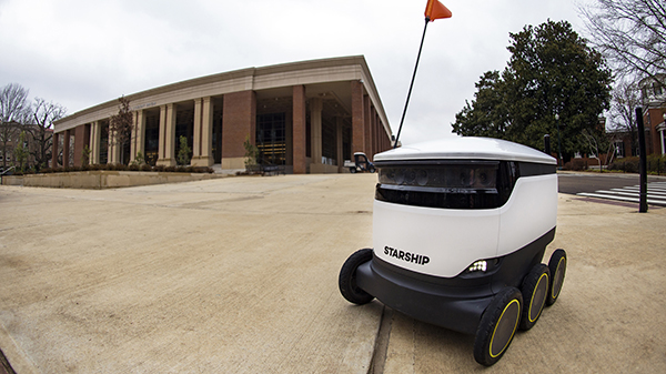
As University of Mississippi (UM) students resume classes for the spring semester, they are sharing the campus’ sidewalks with a fleet of robots that can deliver meals at the push of a button.
Starship Technologies has launched robot food delivery services at the university, the first in the Southeastern Conference to have autonomous delivery robots.
Beginning Jan. 22, Ole Miss students, faculty and staff can access the Starship Deliveries app (iOS and Android) to order food and drinks to be delivered anywhere on campus, within minutes from any of the 30 robots serving UM. The service will work in conjunction with student meal plans.
“Ole Miss Dining is focused on the continued utilization of advanced technology to enrich the student, faculty and staff dining experience,” said Chip Burr, resident district manager of Ole Miss Dining Services. “We are excited about the expansion of our mobile ordering operation and the new opportunities this partnership creates.”
The robots use a combination of sophisticated machine learning, artificial intelligence and sensors to travel on sidewalks and navigate around obstacles. The computer vision-based navigation helps the robots to map their environment to the nearest inch. They can cross streets, climb curbs, travel at night and operate in both rain and snow.
A team of humans also can monitor their progress remotely and take control if needed.
By making food and drink more accessible, the Starship robots save time and reduce stress, aiming to make the busy lives of the Ole Miss community a little easier, Burr said.
Items can be ordered from Starbucks, Chick-fil-A, McAlister’s, Panda Express, Which Wich, Qdoba, Einstein Bros. Bagels, Raising Cane’s, Steak ‘n Shake, Freshii, Papa John’s and Sambazon. After choosing their items, users select their location by dropping a pin on the campus map where they want their food delivered.
The app allows users to watch the robot’s journey in real time through an interactive map. Once the robot arrives, the user will receive an alert and can meet the robot and unlock it through the app.
The delivery usually takes just minutes, depending on the menu items ordered and the distance the robot must travel. The robots can carry up to 20 pounds.
Starship Technologies operates commercially on a daily basis around the world. Its robots have traveled more than 350,000 miles and completed 100,000 autonomous deliveries.
“We’re honored to be able to help make lives a little bit easier for Rebels across the Ole Miss campus by offering the world’s leading autonomous delivery service,” said Ryan Tuohy, senior vice president of business development at Starship. “Whether it’s getting breakfast delivered in the morning or having a late-night snack, our robots are here to serve students, faculty and staff at all times of the day.”
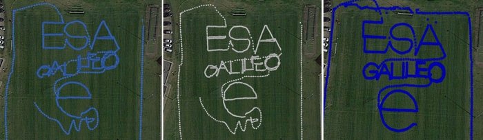
To test the accuracy of the competing satnav smartphone apps, the words ESA and Galileo were traced along ESTEC’s football field. The left side uses single-frequency GPS and Galileo signals, the center uses dual-frequency signals from the two constellations while the right is with precise corrections. The word “ESA” is 15 meters high, while “Galileo” is 7 meters high. (Photos: ESA)
News from the European Space Agency
Europe’s students and young researchers were challenged to design a smartphone app to take advantage of Galileo’s dual-frequency signals. The winning entries should soon be available to the public.
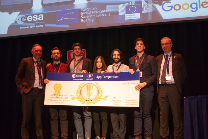
Run by ESA in collaboration with the European Global Navigation Satellite Systems Agency — GSA — plus the European Commission with the support of Google, a total of five teams made it to the final, which took place at ESA’s ESTEC technical heart in the Netherlands.
Following on from last year’s inaugural competition — which has already resulted in the winning app becoming publicly available — this year’s event challenged teams to make use of the dual-frequency capability of the latest smartphones running Android 8.0, including and computing dual-frequency positioning solutions from satnav signals to compare them with their single frequency equivalents. The competition slogan was “Galileo give mE5,” referring to Galileo’s dual E1 and E5 frequencies.
“Galileo give mE5”
The objective of the competition was to reach meter accuracy or less worldwide in unobscured sky, while allowing the user to select Galileo-only positioning, GPS-only positioning and the combination of both on a simultaneous basis, with the potential to include other satnav constellations in turn.
The winner was selected based on technical checks and a jury’s vote. Separate awards were also given to the most innovative app and the winner of a public vote.
The multinational O ThiSaVRoS team — named after the Greek word for treasure — developed the “GNSS Android-based Dual Frequency Iono-estimating Precise Point Positioning” or GADIP3 app.
The multinational ‘O ThiSaVRoS’ team – named after the Greek word for treasure – developed the ‘GNSS Android-based Dual Frequency Iono-estimating Precise Point Positioning’ or GADIP 3 app, winning the ESA-EC-GSA Galileo smartphone app competition 2019. (Photo: ESA)
Winners
The app allows users to perform reliable positioning fixes in real time — selecting which constellations to employ and a choice of single or dual frequency signals — while advanced users can modify the way the positioning is performed, and log all available data for follow-up analysis.
“Our mission goal is to provide precise positioning to everyone,” explained team coordinator Lotfi Massarweh. The O ThiSaVRoS team performed analysis on more than 120 hours of data from stationary, pedestrian and mobile testing to come up with a pre-processing approach involving rejection of signals from low elevation and under a specific signal-to-noise ratio.
The five-person team hail from China, Greece, Italy and Spain, studying at Portugal’s Instituto Superior Técnico Lisboa, Delft University of Technology in the Netherlands, Germany’s Leibniz Universität Hannover and the Universities of Bath and Nottingham in the UK. They worked remotely to develop and test the app over the previous six months.
NavGate allows geo-tagging in augmented reality
The NavGate smartphone app allows the sharing of geo-tags in augmented reality via the phone’s camera, as well as on maps. (Image: ESA)
As their app’s name suggests, O ThiSaVRoS hope to achieve precise point positioning in future, made possible by dual-frequency signal availability, to come close to single-metre-scale precision.
Second place went to the ESTEC-based Team GNSS Tonic’s NavGate app — aimed at bringing people together socially to interesting locations. Users can tag sites of interest to be seen by other people, with the resulting geotags viewable for others either on a map or else directly in augmented reality through their phone’s camera. NavGate could potentially be used for everything from sharing dining recommendations to fishing spots, or meeting up with people during an evening out.
The third prize to the Step with GNSS app by the Romania-based Space Walkers Team, designed to gather data on the paths of users walking outdoors. This game based app is backed up by a server application collecting data from the app users and analysing GNSS performance worldwide or regionally.
Single versus dual frequency
The winner of both the public vote and the most innovative app award went to Universitat Autònoma de Barcelona’s Inari Team and their Inari app.
Inari allows users to select various positioning modes or customise their own, selecting which algorithms and which corrections should be employed as well as specifying constellations and signal frequency. The app can also highlight jamming or spoofing that might be influencing the positioning accuracy.
ESA’s technical evaluation team performed tests of the competing apps in the days running up to the final, including tracing out ESA GALILEO as accurately as possible across the establishment’s football field.
The speaker of the jury, Frank van Diggelen from Google, congratulated the teams on their efforts. “Dual frequency on smartphones is a quite new development, and you really are pioneers in this. The manufacturers are still trying to get things right, and you’re helping them do that bit better. Doing anything for the first time is hard but it’s good to be first, so congratulations for that,” he said.
Galileo smartphone app competition final
The receiver chipsets inside smartphones routinely make use of Galileo in combination with several other satnav constellations — the U.S. GPS, Russian Glonass and Chinese BeiDou. These chipsets function in ‘black box’ style, making the resulting positioning fixes accessible to users, but without giving any option to the user to select which constellation to employ — or information on Galileo’s particular contribution to the phone’s overall positioning performance.
However, in newer Android smartphones it has become possible to access the raw signal measurements used to compute position, opening the door to the development of applications where the user can indeed select which constellations to employ.
The very latest models also allow the use of dual satnav frequencies, giving a major boost to positioning precision. The higher chip rate of the additional frequency allows the chipset to compensate for signal propagation errors from the signals’ journey through the ionosphere — the electrically active outer layer of atmosphere — and reduces false ‘multipath’ detections caused by signals reflecting off buildings.
European students and researchers are invited to compete in a new Galileo smartphone app competition sponsored by the European Space Agency (ESA).
The goal is to develop an app capable of performing fixes using raw Galileo satnav measurements. An earlier Galileo smartphone app competition has already resulted in the winning app becoming publicly available.
This year’s event challenges teams to make use of the dual-frequency capability of the latest Android 8.0 smartphones, to compute dual-frequency positioning solutions from raw satnav signals to compare them with their single frequency equivalents.
The competition is run by ESA in collaboration with the European Global Navigation Satellite Systems Agency (GSA) plus the European Commission with the support of Google.
The Galileo app competition is open to all students from European universities and trainees in posts at European research and development organizations.
“The inaugural Galileo smartphone app competition was open solely to ESA graduate trainees, but the response was so great that this time we have opened up to students and young researchers across Europe, forming teams of three to five people,” explained ESA Galileo Services Engineering Manager Rafael Lucas Rodriguez.
The set objective is to reach sub-meter accuracy worldwide in unobscured sky conditions. The app should allow the user to select Galileo-only positioning, GPS-only positioning and the combination of both on a simultaneous basis, with the potential to include other satnav constellations in turn.
The receiver chipsets inside smartphones routinely make use of Galileo in combination with several other satnav constellations — the U.S .GPS, Russian GLONASS and Chinese BeiDou. These chipsets function in “black box” style, making the resulting positioning fixes accessible to users, but without giving any option to the user to select which constellation to employ — or information on Galileo’s particular contribution to the phone’s overall positioning performance.
However, in newer Android smartphones it has become possible to access the raw signal measurements used to compute position, opening the door to the development of applications where the user can indeed select which constellations to employ.
The very latest models also allow the use of dual satnav frequencies, giving a major boost to positioning precision. The higher chip rate of the additional frequency allows the chipset to compensate for signal propagation errors from the signals’ journey through the ionosphere — the electrically active outer layer of atmosphere — and reduces false ‘multipath’ detections caused by signals reflecting off buildings.
“As a first step, teams submit a proposal of not longer than 20 pages, summarizing the application to be developed,” explained ESA navigation engineer Nityaporn Sirikan. “These proposals will be evaluated by a jury composed of representatives of ESA, GSA, the EC and Google, with the top five proposals selected to develop their app further, receiving on loan a state-of-the-art dual frequency satnav smartphone and receiving general guidance and technical support.”
The competition launched on Sept. 24; teams are invited to submit their proposals to [email protected] by Nov. 12, and will be informed of the jury’s response to their proposal by Nov. 26. The competition final is scheduled for April 18, 2019, at ESA’s ESTEC technical centre in Noordwijk, the Netherlands. Terms and conditions of the competition are posted here.
The first- and second prize-winning teams will win attendance to the ESA and EC International Summer School on Global Navigation Satellite Systems in Portugal. Additional prizes will be available to the most innovative app and the winner of a public online vote, to be undertaken during the final.
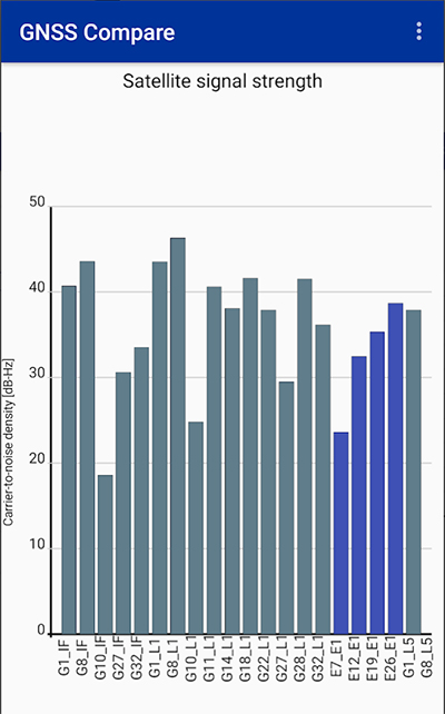
Taking advantage of the recent release of Android API 24 and the GnssMeasurement class, developers now have access to unprocessed pseudorange measurements in certain smartphones.
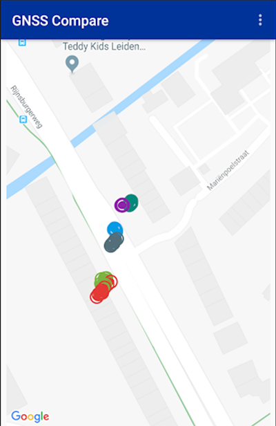
GNSS Compare is basically a tool for scientists to compare their algorithms. For those who are not GNSS experts, it can also serve as a teaching tool on the subject.
The Galileo Smartphone App Challenge was about creating a smartphone application that will allow the user to choose which satellite constellation to use for PVT estimation.
Screenshot: TFI Systems
The aim was to increase the awareness about the European Union’s Galileo satellite navigation program and also to allow users from the public to compare the performance of Galileo signals with the performance from other global satellite navigation constellations.
The app has been tested on Samsung Galaxy S8 and Xiaomi Mi 8 phones. To download, visit the store.
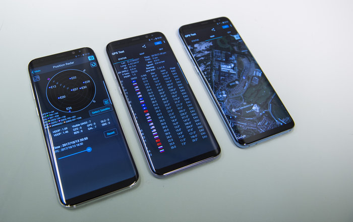
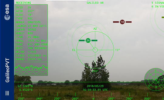
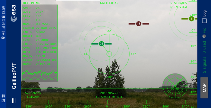
The European Space Agency (ESA) has released an augmented reality view of Galileo satellites in the sky close to its technical centre in the Netherlands.
The image comes from a Galileo-focused satnav app for Android smartphones, developed by ESA engineers. ESA ran an internal competition for its trainees to develop an app capable of making positioning fixes using only Galileo satellites.
“As part of our support for the competition, we developed our own app on a voluntary basis to serve as a benchmark,” said Paolo Crosta of ESA’s Radio Navigation Systems and Technology section. “We included this augmented reality view, so users can ‘see’ the satellites their smartphone is using as they hold it up to the sky.”
Galileo satellites viewed in smartphone app. (Photos: ESA)
The positioning calculations and assistance data functions for the app were developed by Paolo, with telecom engineer Tim Watterton contributing the main structure of the app, together with how it looks and its user interface.
“The satellites are overlaid in real time on the camera view in their predicted positions in the sky, based on ‘ephemeris’ information, assistance data that describes the current satellite orbits with high precision,” Watterton said. “When a signal is being received, the satellite is shown in green, overlaying the predicted position. The satellite shown in red is one of the two placed in elongated orbits, but these satellites are expected to be used soon in the operational constellation. Satellites colored orange are transmitting, but the signal is not detected, which may be due to obstruction by terrain or buildings.”
Panning the phone around to position the crosshair over a green-colored satellite adds additional information, such as its signal status, pseudorange (the uncorrected distance the signal has traveled to reach the receiver) plus the satellite’s manufacturer and launch date, among other items.
The reference app is now being tested with the hope of making it publicly available on the Google Play Store. Following the competition, the trainees are also testing their own apps with the goal of releasing them.
Testing of the three Galileo apps took place in May. (Photo: ESA)
ESA challenged its young graduate and national trainees to develop a smartphone app to perform satnav fixes using only Galileo satellites.
Three teams developed apps in their spare time, presenting their results to a jury of experts from ESA, the European Global Navigation Satellite Systems Agency (GSA) and Google.
“I’m very impressed,” said Javier Benedicto, ESA’s Galileo programme manager. “With little detailed knowledge of satellite navigation, these teams have developed something that didn’t exist just a few months ago. Working on Galileo we love to see that the systems we’re putting together can reach widespread application and inspire new uses.”
The winning Galfins Team put together the GNSS Compare app that promises to turn a smartphone into a “research lab in your pocket” to test Galileo performance in isolation or in combination with other systems. Their prize is to attend an ESA and European Commission-sponsored GNSS Summer School in Austria.
The final presentation and results of ESA’s internal Galileo smartphone app competition took place in the Erasmus centre of ESA’s Erasmus technical centre on May 31. (Photo: ESA)
“Only one of our four-strong team started the challenge with any knowledge about satellite navigation,” said Mateusz Kraiński of the Galfins team. “The rest of us come from different areas — for example, I’m working on the European Robotic Arm project, due to launch at the end of next year. We have learnt a lot and the radio navigation experts at ESTEC were a great source of support.”
“We see a need on the market for such an application, so we will definitely continue with the development. The application will be made available for download when ready, and the project will be released as open source soon after.”
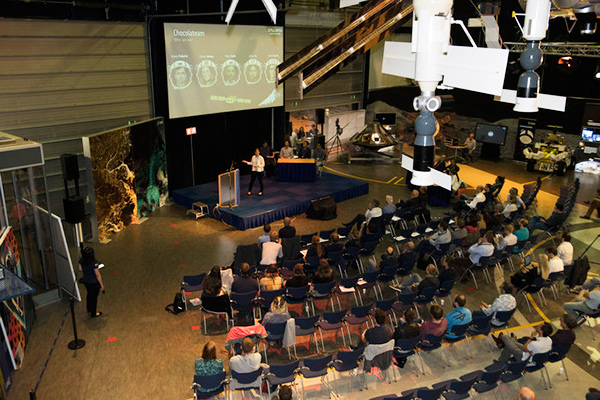
The other two teams were also commended for their work; Chocolateam developed a richly-designed game-based app, giving the user the feeling of observing the Galileo satellites from a spacecraft, while Team 5G distinguished themselves by writing all their own navigation algorithms from scratch rather than relying on open source software.
The challenge was to design an Android smartphone app that allows users to compute and visualize their position based solely on Galileo measurements, as well as the possibility of selecting a combination of satnav constellations to assess their performance.
Testing the three apps entered in the Galileo smartphone app competition in the grounds of ESTEC, working in pedestrian mode. (Photo: ESA)
The receiver chipsets inside smartphones make use of Galileo signals in combination with several other satnav constellations — the U.S. GPS, Russian GLONASS and Chinese BeiDou. These chipsets function like “black boxes,” making the resulting positioning fix accessible to users, but not giving any option for the user to select which constellation to employ.
Current phone applications only display general satnav status information, such as which satellites are contributing to the positioning fix, their visibility parameters and overall power levels. This is not sufficient to single out Galileo’s contribution to the phone’s overall positioning performance.
However, in newer Android smartphones it has become possible to access the raw signal measurements used to compute position, opening the door to the development of applications where the user can indeed select which satellites to use.
The teams received one Galileo-enabled smartphone each for developing and testing the app.
ESA’s Director of Technology, Engineering and Quality supported the teams by supplying dedicated software modules to simplify computations of the phone position. During the competition, a technical advisory team also developed an internal app as a benchmark.
The app, named Galileo PVT and developed by ESTEC engineers Paolo Crosta and Tim Watterton, includes an augmented reality system allowing users to “see” the Galileo satellites from which they were receiving signals in the local sky.
“This was a very useful exercise because it helps us understand the needs of satnav app developers in Android,” said the lead advisor, Paolo Crosta. “Then, once the apps were complete, we tested them together, here on the grounds of ESTEC, working in stationary, pedestrian and vehicular modes.”
“Congratulations to all the teams here today,” said Frank Van Diggelen from Google, who had just come from a satnav raw measurements workshop hosted by GSA. “It’s been great to be here and see all the activity around raw signal measurements. Our aim has always been to raise standards by making these measurements available, to let developers see what’s happening inside. And the work you’re doing here is feeding back to chip and smartphone manufacturers, to help change and improve them for the future.”
A team of Rohde & Schwarz engineers have found a new way to hack Pokémon Go, the massively popular app that debuted last month.
The engineers are generating GNSS data with a Rohde & Schwarz signal generator, and feeding the signal directly into the mobile device, making it possible to collect dozens of Pokemon right in the lab.
The team produced a video showing the hack, which has received almost 400,000 views on YouTube, and received coverage from Bloomberg and The Verge.
The Munich-based Rohde & Schwarz team provides the following hardware diagram of the setup:
The team also describes the technical details:
“The setup is a little proof of concept by simulating GPS signals with an HIL — hardware in the loop — interface, which can also be used for a flight simulator or similar applications.
“A R&S-SMBV100A vector signal generator serves as a source to simulate real-life GNSS RF signals. We use a custom PC software with a joystick controller for the ultimate gaming experience *wink* — it may as well be controlled with a mouse. This software streams HIL commands to the signal generator over a LAN interface and interpolates position and velocity changes. The interpolation will be done according to a desired inertia model — pedestrian/car/plain — we actually used a slow car here with a maximum speed of ~15km/h. This is useful, for instance, if you assume that cars will not make 90° turns.
“We set the GNSS coordinates of the signal generator to some arbitrary position in the world and start the HIL mode — this will result in a ban if you jump quickly from Moscow to Sydney! You have to wait a reasonable amount of time in between.
“The signal generator simulates a real-life GNSS RF signal, which is fed indirectly into the mobile phone and to a u-blox M8 GNSS receiver. This is why we use an RF splitter. The losses from antenna to device are roughly 30 dB. We therefore generate a signal of -80 dBm in order to achieve the common GNSS signal strength of -110 dBm at the device. The idea behind the shielding box is to protect the device from the signal from outside. You could also build the setup in a cellar.
“We use the corresponding u-center v8.11 software, which is connected to the GNSS receiver to visualize our current position using a Google Maps plug-in. The u-blox is connected via USB to the computer.
“By doing so, we create a closed-loop realtime GNSS simulation with user feedback and interaction.”
Esri has unveiled a Human Health and Climate Change App Challenge, calling on the worldwide GIS community to create apps that help communities visualize, understand and combat the health impacts of climate change. Esri will award three winners more than $15,000 in cash prizes or the equivalent in software. The deadline to enter is August 14.
The app challenge is part of Esri’s comprehensive effort in support of the White House Climate Data Initiative under President Obama’s Climate Action Plan. “Esri is committed to helping communities work smarter and more efficiently to become more livable and, as a result, more resilient to climate change,” said Esri president Jack Dangermond.
Participants are encouraged to create apps using Esri’s ArcGIS platform that provide decision-making support for health professionals and empower the public to take action. Apps should help private and public organizations combine open data to gain new insights into the impacts of climate change on health.
“Understanding the geography of climate change is critical to mitigating its health effects and creating a vibrant and sustainable future,” said Este Geraghty, Esri chief medical officer.
The app challenge is open to everyone — including developers, start-ups, governments, academics and nongovernmental organizations. Participants are encouraged to use the growing pool of open data and Esri apps, maps, services and APIs to develop their app.
Judges will select the top three apps to be highlighted at the Esri Health and Human Services GIS Conference in September. In addition to awarding prizes, Esri will feature the winning apps on its collaborative resource portal.
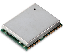
The GN-87 multi-GNSS receiver by Furuno Electric Co.
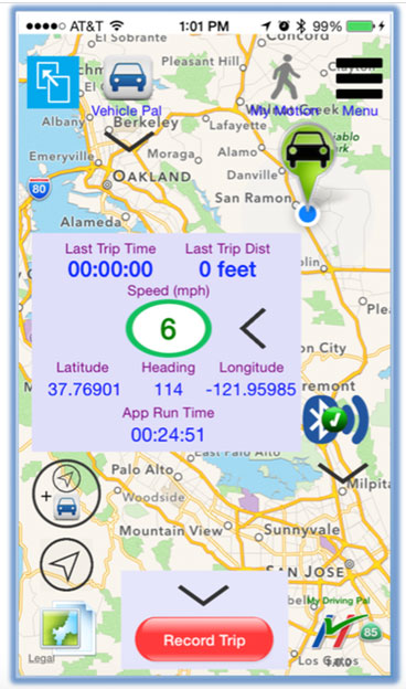
Furuno Electric Co.’s latest multi-GNSS receiver module, the GN-87, has been adopted for use in the new My Driving Pal (MDP) device.
The MDP device and app communicate with each other via Bluetooth low energy (BLE). When the MDP device and a phone running the MDP app are within range of each other (approximately 15 meters), the device keeps its internal GPS in idle mode. When the phone is out of Bluetooth range and the object that is carrying the MDP device is moving (for instance, under the seat of a stolen bicycle or in the pocket of a wandering child), the MDP device activates its built-in GNSS receiver and cellular modem, tracks the asset, and immediately notifies the user on a phone via remote push notification.
The range is unlimited, because the MDP device will track the asset anywhere in the world, with an accuracy level of meters. To protect user’s privacy, all tracking data remains locally on the phone and is not transmitted to any backend server.
In April, the GN-87 receiver was adopted for the new quadcopter Bebop Drone, made by Parrot SA. The GN-87 provides positioning accuracy and smooth ground tracking because of its multi-GNSS technology, which allows it to receive more satellite data even in harsh environments such as urban canyons.
My Driving Pal (MDP) is a technology startup based in Silicon Valley that develops advanced Internet of Things solutions. MDP’s mission is to improve road safety by enabling vehicle to vehicle and vehicle to infrastructure communications. A small percentage of new vehicles are connected, but still the vast majority have no connectivity, not including motorcycles and bicycles. The MDP product delivers a suite of security, monitoring, and tracking applications, from delivering remote notification on phone if interior temperature of car gets too high, to automatically tracking the bike, if it’s ever stolen.
For more information on the MDP device (capabilities, availability, distribution, retail or partnerships), send an email to [email protected], or follow MDP on Facebook.