Tag: software development kit

  • Hexagon expands AR capabilities with Immersal acquisition

    Hexagon expands AR capabilities with Immersal acquisition

    Hexagon AB has acquired Immersal Oy, an innovator of spatial mapping and visual positioning solutions for producing augmented reality (AR) applications.

    AR applications enhance real-world experiences by augmenting a user’s visual perception with the display of digital content in the physical world.

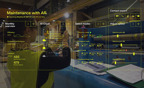
    AR’s ability to weave context-specific, 3D information into physical spaces provides endless opportunities to save time, improve performance and reduce costs across a wide range of industries and applications — from surveying, construction, public safety and manufacturing to maintenance, training and navigation applications.

    An immersive experience can help boost task efficiency, improve safety protocols, optimize workflows and increase collaboration.

    The Immersal SDK (software development kit) allows developers to merge and “anchor” digital content to real-world objects – with precise accuracy to their actual location in the physical space — by enabling a user’s mobile device to locate and orient itself in the surrounding physical world using machine-readable maps.

    The maps, which are used for visual positioning, are constructed from image data supported by various mapping devices (including mobile phones) and hosted in the Immersal Cloud Service.

    “Hexagon has long been a leader in delivering smart digital realities that combine inputs from reality capture sensors with advanced visualisation software and tools to enable remote, location-based intelligence. This acquisition puts the power of these insights into the hands of those on-site, enhancing their field of view with superimposed digital information, meaning they can literally do more with what they see,” said Hexagon President and CEO Ola Rollén. “For example, direct access to information about an asset — while working with that asset — including step-by-step instructions on how to repair it, can streamline maintenance tasks while reducing material waste and re-work.”

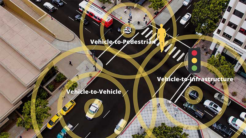
    Immersal has years of experience developing AI and machine learning-based spatial anchor technology, which “anchors” virtual objects or models for viewing on different devices in the same position and orientation. This unlocks a wide variety of location-based solutions and services — from consumer-oriented augmented reality applications in gaming and media and entertainment to digital twin solutions on an enterprise scale.

    Immersal’s technology can map large spaces — both indoors and outdoors — and works both offline on-device and online using the Cloud Service.

    Founded in 2015 and headquartered in Helsinki, Finland, Immersal will operate as part of Hexagon’s Geosystems division. The acquisition has no significant impact on Hexagon’s earnings.

    Image: Hexagon
    Image: Hexagon
  • Cohda Wireless launches advanced C-V2X software development kit

    Cohda Wireless launches advanced C-V2X software development kit

    Cohda Wireless has released an updated version of its C-V2X software development kit (SDK). According to the company, the SDK now features an extensive range of useful applications and tools, as well as a virtual simulation tool. The virtual simulation tool allows users to test their applications before real-life deployment, through high-quality, simulated drives that provide full playback capabilities for actual drive tests.

    The Cohda C-V2X SDK is a self-contained virtual machine that allows anyone with previous embedded Linux experience to quickly compile and run C-V2X applications in conjunction with C-V2X development platforms, such as those featuring the Qualcomm 9150 C-V2X chipset solution, the company said.

    The SDK includes source code for red light warning and road side alert to demonstrate the various APIs and enable quick application development. It also features binaries for forward collision warning, emergency electronic brake light, curve speed warning, RoadWorks warning, blind spot warning, hazard location warning for China, abnormal vehicle warning for China, speed limit warning for China, red light violation warning for China and green light optimal speed advisor for China. It includes tester control interfaces for performing conformance tests, as well.

    “The functional benefits of this SDK, especially the vsim component, have significant tangible value in the C-V2X ecosystem,” said Fabien Cure, chief engineer at Cohda Wireless.

    As they are radio agnostic, Cohda’s V2X solutions support C-V2X and dedicated short-range communication.


    Feature image: Cohda Wireless

  • New version of Global Mapper SDK supports S-52 marine chart symbology

    Photo: Blue Marble Geographics
    Photo: Blue Marble Geographics

    Blue Marble Geographics has released a new version of the Global Mapper software development kit (SDK), providing software engineers with the means to embed the latest geospatial technology into their custom applications.

    Version 20.1 incorporates many of the functional upgrades introduced in the recent release of the desktop version of the software.

    Blue Marble’s GIS software has been used by GIS professionals for 25 years. Users come from all industries including software, oil and gas, mining, civil engineering, surveying and technology companies, as well as government departments and academic institutions.

    Global Mapper’s GIS application is capable of displaying, converting and analyzing virtually any type of geospatial data. The Global Mapper SDK and accompanying Lidar Module SDK provide software developers with a toolkit for accessing much of this functionality from within an existing or custom-built application.

    The SDK also enables the creation of custom toolbars and extensions to enhance the data processing and analysis functionality of the standard version of Global Mapper. This capability allows in-house developers to create a unique version of the application to meet their specific needs or for software companies to build custom products for commercial distribution.

    Highlights of the latest version of the SDK include:

    • A new function to allow querying of elevation from a specific list of elevation layers
    • Significant speed improvements when working with vector data with attributes
    • Faster viewshed calculation on computers with multiple cores
    • Support for downloading vector features from Esri RESTful data sources
    • S-52 point symbols for S-57 and S-63 marine chart files
    • Updated SHIFT_LAYER script command to support shifting in the Z (elevation) direction.
    • Support for several new formats including, OpenFlight and HEC-RAS raster and vector files

    The supplementary Lidar Module SDK now offers:

    • The ability to select points based on their proximity to other lidar points and/or line features
    • A new option to update the return number/count when deleting multi-return points

    “Global Mapper’s reputation as a powerful geospatial data processing and analysis application is well known throughout the world and software engineers are increasingly integrating these tools into a wide variety of development projects,” said Patrick Cunningham, Blue Marble president. “The Global Mapper SDK is unrivaled in its ease of deployment, data format support, affordability, and in its adaptability, allowing it to meet the ever-changing needs of today’s geospatial software development sector.”