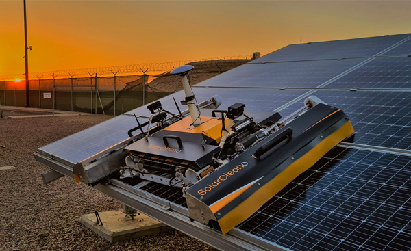
A SolarCleano F1A robot tackles a tough cleaning challenge on a solar farm in Saudi Arabia. (Photo: SolarCleano)
SolarCleano, based in Garnich, Luxembourg, makes robots that clean large solar panel installations using GNSS receivers and corrections from Swift Navigation. We asked Christophe Timmermans, SolarCleano’s managing director, a few questions about its technology.
How often do solar panels need to be cleaned?
For decades, it was believed that solar panels did not need to be cleaned due to their angle to the ground and rain. Nowadays, however, the cleaning of solar panels is widely accepted as necessary to optimize a plant’s return on investment (ROI).
How much time per sq. meter do your machines take to clean solar panels?
To provide the fastest possible ROI to our customers, we developed a range of robots to best address the needs of various solar plant layouts. A large utility-scale project with high level of soiling losses in a desert environment will need a very fast and reactive cleaning solution such as our SolarBridge B1, which can clean 24/7/365 fully autonomously. The most suitable solution for a farm rooftop in Germany that needs to be cleaned three to four times a year might be our F1 model, which can clean the equivalent of up to two soccer fields a day. It is designed for rooftops, floating panels and mid-size plants up to 50 MW. While the speed of cleaning is a very important variable, the quality of cleaning is often considered as the driver to performance, which is why we propose different types of brushes depending on the soiling types. Plus, the robot speed can be modified according to the soiling level.
Why do robots need GNSS receivers to clean solar panels?
Moving on inclined, wet glass surfaces makes odometry unreliable because robots might occasionally slip. Therefore, GNSS is the most reliable way to continuously monitor their exact position. Our robots also need path planning because they cannot operate randomly like lawn mowers. Safety is obviously a major concern; we need a very high localization accuracy to ensure that robots don’t fall off the panels. Finally, the largest solar plants are developed in dry, remote locations with high irradiation such as the Sahara, Atacama and Australian deserts. GNSS allows us to have very accurate localization even in those remote areas. In addition, this solution can easily be installed on already-existing solar plants with little capital expenditure.
What spatial accuracy requirements do the robots have for this task?
Safety is our absolute priority. Therefore, our robots need an accuracy of less than 3 cm. They also need to be aware, in real time, of changes in their surroundings, such as maintenance teams, animals and uneven ground.
On large solar farms, GNSS receivers always have a clear line of sight to the satellites and do not suffer from multipath. So, what are the key technical challenges?
Our robots have the additional advantage that they do not need to drive very fast. However, we need to manage fleets of robots on the other side of the world in regions difficult to access and with harsh weather conditions, such as very high or low temperatures and the accumulation of dust behind panels due to air vortices. We need to be able to perform remote maintenance and solve any issue from our control center in Luxembourg. These challenges make our robots increasingly robust. With a current fleet of more than 300 robots around the world, we collect lessons every day to ensure a greater reliability for our upcoming generations of robots.
Why did you choose to partner with Swift Navigation?
We share a vision with Swift: “Accessible automated solutions serving sustainable goals.” We also share other important values, such as “iterate quickly” and “focus on what matters.”
The physical and digital world are integrating. We are nearing the edge of the analog universe. Physical immersion is giving way to virtual immersion. It is the virtualization of products and services in the evolution of technology. Michael Saylor calls it the sixth wave of software engineering. We are moving away from externally experiencing data and are moving towards actively interfacing with data directly in virtual space.
“You can Zoom anywhere at the speed of light and bend time and space.” — Michael Saylor
The world of tomorrow is already here. We are waking up to it. The blips of information at the fringes are coming nearer. The horizons of time are as far as one can see into the future and the past. How far can you see? From wherever you are there are others who can see a little further. Look forward. Look back. Others are ahead and behind. They exist where time is most comfortable for them. Some take up positions living in the past. Some stake their place as far into the future as they are able. Look towards those early adopters. Ask them what they think. They see more clearly the blips of information out on the horizon.
What are those blips? How will they impact the geospatial community? How can you position yourself to take advantage of the coming trends?
America needs to go back to work and America’s infrastructure is old and in disrepair. In 2019, Congress introduced H.R.4687, the SMART Infrastructure Act, a $2 trillion bill but it never made it out of the House. However, that bill is being reintroduced. This time it will become a bill putting America back to work and its price tag will likely eclipse the previous bill. It will address infrastructure — all types of infrastructure: physical, data, cybersecurity, health, financial, transportation, energy, and communications. It will be a primary theme for the next two decades. Get ready! Change can happen fast and it’s about to accelerate.
“The future happens slowly and then all at once.” — Kevin Kelly
Rebuilding this infrastructure will require geospatial technologies. STEM has been the siren call for the past 30 years and for good reason. Those who heeded the call and invested their education into coding, engineering, data science, geospatial technologies, mathematics, artificial intelligence, and other STEM related fields are going to lead the coming workforce. Now is the time to get certified and establish your credentials.
Take the case of architectural design and construction. It used to be blueprints drawn on light tables. That is how I learned to do it back in the 1970s. Then it all moved to computer aided design (CAD) drawings. Now, urban planners and architects create immersive 3D virtual reality (VR) visualizations. That is becoming standard practice.
Project managers used to spend their day making their rounds walking the site ensuring the project was being built to specifications. However, that is changing. Soon, each worker’s safety glasses will have built-in augmented reality (AR). They will build their portion of a project exactly to plan. Project managers will connect with workers in the field and see the project they are working on progress in real-time while in their office on 3D models.
When the project manager does walk the site he or she will be wearing augmented reality (AR) head-up displays and able to compare the physical construction to the digital model in real-time. Backhoe and excavator operators will grade to exact precision. Robots will be common at construction sites assisting operations and enhancing current capabilities. Unmanned aerial vehicles (UAV) will fly regular patterns over construction sites. Heavy-lift UAVs will supplement cranes for some operations. Subsurface structures, whether buried beneath the ground or behind a wall will be digitized with precise location data making future replacements and repairs swift and easy. The uses of geospatially dependent technologies will continue to grow. The construction worker of tomorrow will be very different than the one of today.
Photo: Trimble
The new infrastructure will be built with smart technologies and incorporate renewables and “green energy” initiatives with a responsible approach to sustainability; for example, roadways will have embedded peizo-electric crystals in the asphalt to generate electricity from passing vehicles. The electricity will charge batteries that will power smart sensors embedded in the street and provide power to street lights with sensors and 5G networks along the roadways. Excess power will transfer to other microgrids for use elsewhere. Energy will also come from capturing wind on top and along the sides of buildings, along roadways, and at tunnel exits and entrances. Thermocouples will capture heat and generate electricity.
Solar power will be generated from panels, windows, films, and even paint surfaces. All of these sources together will feed into microgrids. Some of this renewable energy will convert water to hydrogen for fuel cells, and some will power carbon dioxide (CO2) converters to extract CO2 from the atmosphere and create synthetic fuels. In 2010, Sunexus submitted a geospatial study of the solar reforming process to the Office of Scientific & Technical Information (OSTI). The study showed that nearly 58% of industrial CO2 waste from power plants, cement plants, ethanol production, and natural gas processing could be converted to synthetic diesel fuel.
Image: U.S. Office of Energy Efficiency and Renewable Energy
Besides energy, other smart materials will be used such as small sensors that are geospatially sensitive nanodevices embedded in roads, bridges, tunnels, buildings and other structures. They are wirelessly connected to one another creating a 3D mesh network. These nanodevices continuously report their structural health. This 3D mesh network can detect vibrations passing through it that cause distortions in the mesh framework.
Geospatial artificial intelligence (GeoAI) will profile devices based on their normal statistical ranges. If any data such as location, temperature, humidity, pressure, acoustics or health status exceed the device’s standard deviation the GeoAI will analyze surrounding nodes in the mesh network to depict patterns. Suspect events will immediately come to the attention of emergency services. These microdevices can provide early detection of cracks in a structure or deterioration of a surface protection layer.
The use of these devices extends beyond structural monitoring. More broadly, they have societal applications too, such as for security purposes. When fitted with acoustic sensors they can detect sounds, and by geospatially analyzing the data from many thousands of devices the epic center of a noise event can immediately be located. Take for example a gun shot, fireworks, an explosion, or a vehicle accident. The increased acoustic signal would trigger the GeoAI monitoring the devices to plot a spatial analysis of the acoustic report. The map would alert area would flash red on the monitor at the control center and nearby cameras would zoom in on the location providing images and live video feeds all within moments of the triggering event. The analysts at the control center could immediately assess the situation and dispatch the proper response units.
Embedded devices also serve as seismic sensors blanketing broad areas and are able to record surface vibrations moving through the mesh network. An earthquake would appear as a moving wave field along the network.
Additionally, data from the mesh network can integrate with other devices. It can provide smartphones with precise location data. Imagine no longer standing on a street corner turning in circles trying to figure out which way to go. When connected with the mesh network and looking through AR glasses or the smartphone view screen the path will be illuminated. Autonomous vehicles will connect with the mesh network and have absolute positional accuracy and have awareness of other vehicles, bikes, and pedestrians ensuring a more safe and efficient experience for everyone.
The mesh network can be used as a base layer for georeferencing the world. Notifications, warnings and requests for information can be sent to smartphones within an exact georeferenced location. Imagine being in your third-floor apartment sitting in your chair, listening to music on your headphones and reading an ebook. You are oblivious to the noise outside. An audible alert is sent to your phone and calls your attention. You look at your phone and a message is requesting information related to a possible gunshot at DD°MM’SS.sss N, DD°MM’SS.sss W. You click on the notification and a map opens up. You see it is right outside your window. You go to the window, look outside and see two people duck into a car. You watch as red tail lights drive away. You look back at the location on the street where the vehicle had been and a person is slumped over leaning against a stairwell.
On your phone you press the red alert button on the map application triggering a distress signal and confirming the incident may have been a gunshot and someone has possibly been injured. Emergency services immediately dispatch. Others nearby received the same alert message because it was automatically generated and sent out to all phone numbers within the area defined by the geospatial acoustic solution. Surveillance cameras on the corner of buildings were also triggered by the alert and automatically focused on the origin of the noise. Images of the assailants were captured along with the license plate of the vehicle. As the vehicle drove away a network of surveillance cameras continued following it turn by turn until it was finally intercepted and the occupants apprehended.
This world is nearer than it seems. The technologies are already here. Once the infrastructure bill is passed construction projects will begin and our physical world will begin to integrate with the digital world. The engineers design it. The construction workers and robots will build it. And it will be geospatial technologies holding it all together.
William Tewelow works for the Federal Aviation Administration. He is a graduate of the FAA management fellowship program. He served on special assignment to the U.S. Department of Transportation leading a national strategic geospatial initiative for the White House Open Data Partnership. He is a Geographic Information Systems Professional (GISP) and a speaker for the Maryland STEMnet Scholar program. He was among the first in the nation to earn a Geospatial Specialist Certification from the U.S. Department of Labor while working at NASA Stennis Space Center. He has degrees in Geographic Information Technology, Intelligence Studies, and is completing a masters degree in Organizational Management. William is a 23 year veteran for the U.S. Navy serving as a Geospatial Specialist, Imagery Intelligence Specialist, a Naval Aviator, a Meteorologist, and a Tactical Oceanographer. He is married, enjoys writing and traveling. His favorite quote is, “A man’s mind changed by a new idea can never go back to its original dimension.” — Oliver Wendell Holmes
Bye Aerospace has announced an engineering, development and production collaboration with SolAero Technologies Corp. to put SolAero’s solar cell technology on Bye’s solar-electric unmanned aerial vehicle (UAV), StratoAirNet.
The StratoAirNet. Photo: Bye Aerospace
The StratoAirNet family of UAVs is intended to provide persistent intelligence, surveillance and reconnaissance (ISR) to support commercial and government security requirements. The initial medium-altitude StratoAirNet 15 proof-of-concept prototype is nearing completion and undergoing final assembly.
Potential commercial-mission applications for StratoAirNet include communications relay, internet, mapping, search and rescue, firefighting command and control, anti-poaching monitoring, damage assessment, severe weather tracking, agriculture monitoring, mineral source surveying, spill detection and infrastructure quality assessment.
The solar-cell preliminary design review was recently completed with SolAero engineers. Preliminary flight tests were then conducted on a smaller scale test wing. Following measurements and fit checks, whole-wing solar cell tests will commence on the 15-meter wingspan StratoAirNet prototype.
Photo: Bye Aerospace
Since 2001, SolAero products have powered 170 successful space missions with zero on-orbit failures. SolAero holds the world record for efficiency of space solar cells, with more than 50 patents and disclosures with its 33 percent efficient IMM technology. This solar cell technology achieves the highest commercially available performance level, offering a density exceeding 350 watts per square meter under standard conditions, increasing further under high-altitude, low-temperature conditions, the company said.
“SolAero is one of the world’s leading providers of advanced space solar power solutions,” said George Bye, CEO of Bye Aerospace. “The efficiencies of their solar cells will make the benefits of StratoAirNet even more compelling, allowing the airplane to fly at higher altitudes with almost unlimited flight endurance. We appreciate SolAero’s collaboration with our team and look forward to working together to demonstrate a remarkable pseudo-satellite aircraft capability that many have said is unachievable.”
“We are very excited about our partnership with Bye Aerospace and the future opportunities of the solar-powered StratoAirNet family of UAVs,” said Brad Clevenger, CEO of SolAero Technologies. “The combination of our heritage high-efficiency solar cell technology and integration expertise with the wide range of capabilities of the StratoAirNet UAV family will help to usher in a new era of middle and high altitude commercial and defense applications.”
Geospatial Solutions’ and GPS World‘s Art Kalinski reports from eMerge Americas, held May 4-5 in Miami. SnowLizard Products is a small start up building durable waterproof smartphone cases with Bad Elf GPS and solar panel recharging.
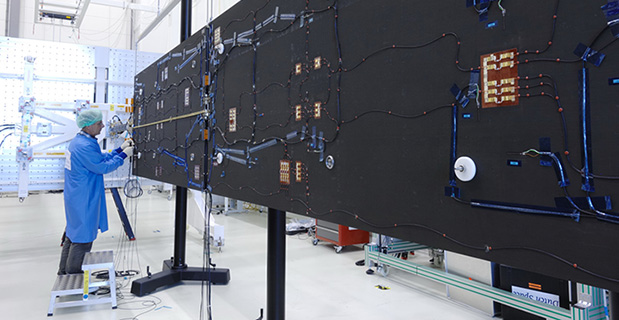
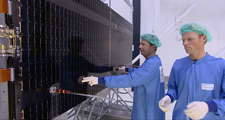
Solar arrays for a Galileo Full Operational Capability (FOC) satellite at the Dutch Space company near Leiden in the Netherlands. A pair of 5 m-long solar arrays supply 1.9 kilowatts of power – about the same as an average household’s consumption. The side of the solar array normally left in shadow is seen here.
By the European Space Agency
As they bathe the ground below them in test navigation messages, Europe’s Galileo satellites are kept alive by the Sun.
A pair of 5 m-long solar arrays supply 1.9 kilowatts of power – about the same as an average household’s consumption. These arrays are sourced from the Dutch Space company in the Netherlands.
Located just outside Leiden, a short drive from ESA’s Technical Centre, the Airbus Defence and Space subsidiary is based in what might appear to be a standard office building, the only clue to its space-based focus being an Ariane 5 frame outside.
Inside its specialized facilities include a class 100 000 cleanroom, space simulation equipment and a “Very Large Sun Simulator” — a giant camera flash able to test the electrical performance of the solar arrays the company supplies to about two thirds of ESA missions — which includes all Galileo satellites commissioned to date, as well as one of their two GIOVE predecessors.
“Think of us as the prime contractor for Galileo’s solar panels,” explains senior project manager Jan Zuidam, overseeing the work for Dutch Space. “We build nothing directly ourselves, but — working with a network of partner companies — oversee the panels’ design, engineering management, assembly and testing, all performed here in these buildings.
The composite panel substrates, sourced from local Dutch company Airborne Composite, are equipped with solar cells in the Airbus Defence and Space facility in Ottobrunn, Germany, with the photovoltaic cells themselves sourced from German company Azur Space Solar Power. It is a bit like the way silicon chips are mounted on printed circuit boards, only on a much bigger scale.”
The cells in question are state-of-the-art “triple junction” gallium arsenide designs, with sandwiched layers optimised for different segments of the solar spectrum.
At Ottobrunn these cells are interconnected together into “strings” that run the length of each panel. The bare cells have also have protective cover glass added at this stage, without which they would be quickly tarnished by the radiation and unfiltered sunlight prevailing in orbit.
Testing
Before delivery to Dutch Space, each panel is thermal vacuum tested at IABG, Germany, followed by the absolute performance measurement and inspection.
Solar arrays for a Galileo Full Operational Capability (FOC) satellite at the Dutch Space company near Leiden in the Netherlands. A pair of 5 m-long solar arrays supply 1.9 kilowatts of power – about the same as an average household’s consumption. The side of the solar array normally left in shadow is seen here.
This includes flash testing to illuminate all the cells at once to check the arrays meet the set power requirements, as well as electrical luminescence testing, where an electrical current is run through each string to make them glow red, basically reversing the way solar cells usually work. Visual inspection is typically enough to ensure all connections are properly linked.
At Dutch Space, the panels from Ottobrunn are integrated together with the mechanisms, typically sourced from local Dutch companies assembled and tested by Dutch Space, into complete solar array wings.
The completed wings are suspended on specially weighted deployment rigs, to compensate for the presence of gravity the 29 kg wings are not designed to endure. Here alignment testing is performed, to check the wings will unfold in a straight line as planned.
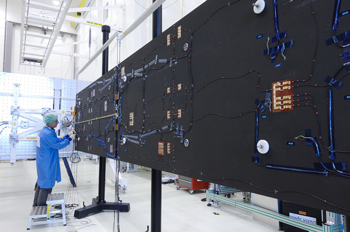
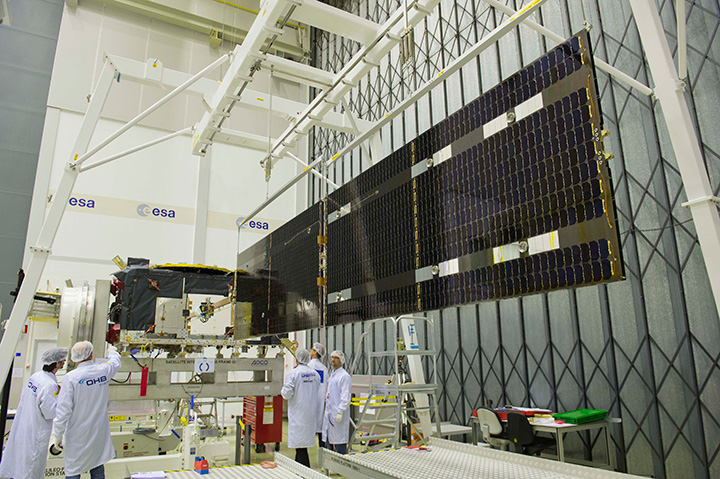
Galileo solar arrays being inspected in the Dutch Space cleanroom. The panels received from Ottobrunn in Germany are integrated together with the mechanisms, typically sourced from local Dutch companies assembled and tested by Dutch Space, into complete solar array wings. The completed wings are then suspended on specially weighted deployment rigs, to compensate for the presence of gravity the 29 kg wings are not designed to endure. Here alignment testing is performed, to check the wings will unfold in a straight line as planned.
“Alignment testing involves the use of reference mirrors and theodolites to check the arrays’ straightness, down to a scale of a tenth of a millimeter at wing tip,” Jan explains.
“In orbit, any bad alignment would be felt by the satellite’s attitude control system, and might even reduce a satellite’s operational life. We also make stiffness tests, which involves hanging weights on a rope on the end of the array, to see what the resulting displacement is. Flex to 100 mm is expected, but not more.”
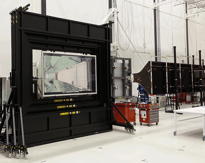
A large‘ambient pressure temperature test chamber can simulate the rapid temperature swings the arrays will experience as they pass between orbital daylight and darkness. A much smaller cabinet does the same in vacuum conditions, and is used for accelerated lifetime testing to simulate the total life of the arrays, although only for a 50 x 50 cm sample array.
Dutch Space has been designing its Advanced Rigid Array family of arrays for space missions since the 1970s, Jan recalls: “Each mission has different requirements. Low-Earth orbiting arrays such as those for ESA’s Automated Transfer Vehicle need protection from erosive atomic oxygen, found at the top of the atmosphere, while deep space missions like Rosetta or the US Dawn spacecraft require low-intensity low-temperature LILT solar cells to go on producing power far from the Sun.
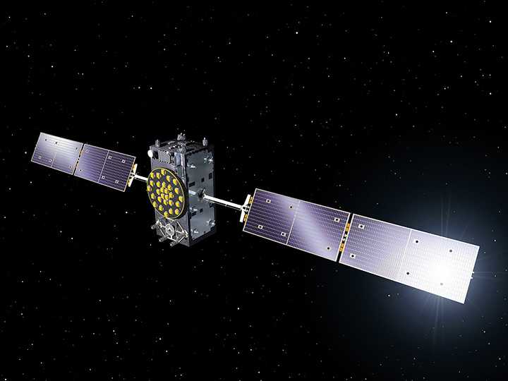
Deployment of the solar wings on the first Galileo satellite ‘Full Operational Capability’ satellite is shown being checked at ESA’s ESTEC technical hub in the Netherlands at the end of June 2013. The navigation satellite’s pair of 1 x 5 m solar wings, carrying more than 2500 state-of-the-art gallium arsenide solar cells, will power the satellite during its 12-year working life.
“Galileo flies in medium-Earth orbit, and in the process passes through Earth’s radiation belts. This heightened radiation exposure implies a higher loss factor of cells, which is accounted for with higher capacity at the start. We design solar arrays based on their end-of-life performance — how can we ensure they will still meet mission requirements after 12 years in orbit?”
Galileo’s solar arrays are also designed to guard against potential harmful electrostatic discharge — a spark caused by the build-up of static — by introducing gaps any charge cannot traverse, as well as other voltage safeguards.
“As a safety margin, Galileo’s arrays can go on operating satisfactorily with the loss of one complete string of cells.”
The completed arrays are sent on to Full Operational Capability (FOC) prime contractor OHB in Bremen, Germany for integration onto the satellites. Although this is not quite the end of the story for Dutch Space.
“We have a 100% record of successfully deployed wings in space and we’d like to keep it that way,” Jan comments. “So we provide training to our customers on handling and storing the wings, and especially in working with our unique hold-down system that keeps the solar arrays stacked on either side of the satellite during launch.”
The panels are delicate, composed of just four layers of carbon fibre, and would break easily if struck hard. They are therefore tied tight against the satellite during the violence of launch.
The Kevlar restraint cables are then severed by thermal knives, with two in place per each hold-down point.
“The Kevlar is weakened gradually instead of suddenly snapping,” Jan explains. “This reduces the amount of shock the arrays experience, compared to the pyros or unwinding rods that other companies use. The arrays then unfold gradually due to springs in the hinges, the process taking a few minutes in all.
“But the system depends on correct tensioning at the outset, which is why we like to be there in person for this point.”
A Galileo Full Operational Capability (FOC) satellite, following on from the first four Galileo satellites already in orbit. A total of 22 FOC satellites are on the way, built by OHB in Germany with navigation payloads from Surrey Satellite Technology Ltd. in the UK.
Dutch Space is well ahead on its Galileo obligations, with 88 substrate panels manufactured and 72 panels equipped with solar cells ready for wing integration. They are carefully stored in gaseous nitrogen until needed, separately from each other for the most part, with integration performed before delivery.“Our continued involvement with Galileo has been very important to the company,” reflects Jan.
“Dutch Space has worked on batch production previously, such as with solar arrays for the ATV and the US Orbital company’s Cygnus supply vehicle to the International Space Station, but the scale of Galileo is even larger.
We have had a valuable learning curve, finding ways to optimize our production flow and working methods so that we’ve been able to reduce the time needed by 50% from the initial satellite to the latest. And all the things we learn should make us leaner and cheaper for future one-off missions as well.”