Tag: South Africa

  • Fugro delivers seabed geodata, employs wind lidar buoys

    Fugro delivers seabed geodata, employs wind lidar buoys

    Fugro has completed a geotechnical site characterization project for DRA Global as part of the proposed expansion of the port of Richards Bay in South Africa.

    Fugro’s self-elevating platforms being positioned in Richards Bay ready for their geotechnical site characterization for the planned port expansion. (Photo: Fugro)
    Fugro’s self-elevating platforms being positioned in Richards Bay ready for their geotechnical site characterization for the planned port expansion. (Photo: Fugro)

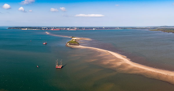
    DRA Global contracted Fugro to acquire critical seabed geodata required for the completion of preliminary engineering and design works. The project began with a cross-continental mobilization of marine assets from Bangladesh and UAE to Richards Bay and was safely delivered despite challenging ground conditions and ongoing COVID-19 restrictions.

    The very soft soils encountered at depths of more than 40 meters below the seafloor required an innovative solution for positioning the two geotechnical drill rigs safely, so Fugro mobilized two bespoke modular self-elevating platforms (SEPs) to acquire high-quality geodata in a wide range of water depths. Their experienced staff, combined with adaptable marine assets and tooling, enabled Fugro to deliver DRA Global’s requirements in full and avoid any data gaps that could have led to an over-engineered design and ultimately higher construction costs.

    “Fugro performed well under difficult circumstances, including challenging site conditions and intense focus on environmental management in sensitive areas, all while working in an operational port,” said Cobus Rossouw, principal marine engineer at DRA Global. “Their robust safety management systems resulted in an investigation completed without a single lost-time incident.”

    Energinet contract for wind lidar measurements

    Fugro’s Seawatch lidar buoys will record continuous wind measurements to support wind-resource mapping for Denmark’s Energy Island development. (Photo: Fugro)
    Fugro’s Seawatch lidar buoys will record continuous wind measurements to support wind-resource mapping for Denmark’s Energy Island development. (Photo: Fugro)

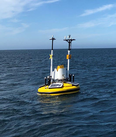
    Fugro has secured a contract with Energinet to provide floating wind lidar measurements for what an offshore artificial energy island, which is being constructed for the Danish Government.

    Fugro will install and operate four SEAWATCH wind lidar buoys at two locations, Energioe Nordsoen and Energioe Baltic, that will act as hubs connecting several offshore wind farms.

    Starting this month October, the buoys will record continuous wind measurements for a minimum of one year to support wind-resource mapping for the two islands, and the engineering and design of the future wind farms. Fugro is already performing geophysical surveys for the Energy Island project under a separate contract to provide Energinet with a reliable de-risked site interpretation.

    The SEAWATCH wind lidar buoy can record wind measurements up to 250 meters above sea level, and wave measurements and current profiles down to the seabed. The buoy also acts as a multipurpose platform for additional metocean sensors and, on this project, will be fitted with sensors to capture geodata on environmental impact parameters.

    Contract for erosion off Indian coast

    OCS Services Pvt. Ltd (OCS), one of India’s marine service providers, has awarded Fugro a two-year contract to support its asset integrity and corrosion management operations off the west coast of India.

    Fugro will help OCS deliver on ONGC’s Protective Coating of Process Platform Project 1, an infrastructure project to maintain and refurbish 32 offshore platforms in seven clusters. The project is expected to be completed by May 2023.

  • Defense small-vehicle navigation system designed for export

    Defense small-vehicle navigation system designed for export

    Photo: Etion Create
    Photo: Etion Create

    A new military vehicle navigation system designed and developed by South Africa-based Etion Create is ready for the local and export markets.

    Designed for harsh environments and battlefield conditions, the CheetahNAV provides outstanding situational awareness, according to Etion Create. The crew of a light military vehicle can count on highly accurate position information, irrespective of whether they are denied satellite navigation. This is achieved through an advanced inertial measurement system (IMS), comprising several aids, including a gyro-compensated compass and an advanced Kalman filter-based algorithm.

    A brochure on CheetahNAV is available here.

    “We are confident that the system provides dead-reckoning horizontal position accuracy of 0.2% of distance travelled in a GNSS denied situation,” said Jan Hurter, senior product manager. “This translates, by way of example, to accuracy of just 200 metres over a distance of 100 kilometers.”

    The CheetahNAV can integrate with any number of different inertial navigation systems (INS) and can be aligned with any of the satellite navigation constellations. Combined with GNSS and compass information, the system enables dead-reckoning and accurate positioning of the vehicle in tactical situations. The tactical grade integral inertial measurement unit (IMU) ensures jamming-free operation.

    Some of the guidance cues the system provides to the crew during tactical maneuvers include the vehicle’s current position, true heading and desired heading towards the next waypoint, current speed and desired speed to reach the next waypoint or destination on time, and the next waypoint or destination. It also shows the pitch and roll attitude of the vehicle and the track it has travelled.

    This data is displayed on a sunlight-readable touch-screen enabled moving map display unit measuring 11.6-inch diagonal, in 16:9 TFT format, with a 1920×1080 resolution. Etion Create is also offering a slave unit for the vehicle driver, as the main display might be positioned elsewhere in a space constrained vehicle. This slave unit, measuring 3.5-inch diagonal TFT, displays information that is specifically required by the driver.

    Significant benefits of the CheetahNAV system include ruggedness for extreme battlefield conditions and 28V or 12V DC operation in line with military standards. Moreover, it boasts a high operational reliability.

    “It is important to note that Etion Create, as original design manufacturer, is focusing the CheetahNAV on the export market, including the possibility of technology transfer for indigenous manufacturing,” said Hurter. “Besides we offer a multi-language option, which is certainly a key advantage in multinational operations that are almost the norm nowadays.”

    The CheetahNAV is non-ITAR controlled, which is the preference of most land forces around the world today to meet their battlefield management requirements.

    Having utilized the building blocks of previously developed military off-the-shelf technologies, Etion Create considers the system to be at a high TRL (technology readiness level), and thus available for the export market.

    Previously called Parsec, Etion Create is a South African original design manufacturer (ODM) with a long-standing international reach and a professional portfolio of technology offerings and experience across a wide range of business sectors, including defence and aerospace, information security, and mining and industrial sectors.

  • Hexagon Geospatial launches HxGN Smart Census

    Hexagon’s Geospatial division has launched its total population and housing census management and workflow solution, HxGN Smart Census.

    HxGN Smart Census makes each phase of the census process smarter and more manageable, the company said. HxGN Smart Census pricing is agile, taking into account a nation’s surface area, population, and Human Poverty Index to ensure that all countries can participate in the digitalizing of their census processes.

    Image: Hexagon
    Image: Hexagon

    HxGN Smart Census integrates traditional GIS functionality with a powerful workflow and workforce management tool to provide a total solution for census strategies: from pre-enumeration mapping, to digital enumeration, to post-enumeration dynamic mapping. It can be used on its own or integrated with a nation’s or organization’s existing GIS infrastructure.

    The solution was developed in consultation with South African GIS experts GeoSpace International, and has already been procured by South Africa and Botswana.

    “With HxGN Smart Census, the census gets completed much faster, and the mobile application has made things much simpler for the field workers who are conducting the interviews,” said Shonisani Maranda, senior GIS officer at Statistics South Africa. “It also significantly increased the data quality, which allows us to achieve the UN sustainable development goals more easily.”

    “Census data informs policy development, the running of public services, and the allocation of resources within a country. It is vital that all nations are able to utilize the right technology to ensure an accurate and effective census,” said Mladen Stojic, president of Hexagon’s Geospatial division. “HxGN Smart Census is capable of democratizing the collection of accurate demographic data, and transforming this information into insights to make informed decisions to shape Smart Change.”

  • Trimble CenterPoint RTX, A Customer Story — Surveying in South Africa

    A video featuring a South African veteran surveyor, telling his story of achieving 2 cm horizontal accuracy with Trimble CenterPoint RTX. Satellite-delivered, survey grade accuracy and no base station required!

    Visit Trimble.com for more information.

  • GLONASS ground station goes live in South Africa

    GLONASS ground station goes live in South Africa

    GLONASS-SouthAfrica

    A GLONASS ground station was officially commissioned in South Africa on Feb. 27.

    “Assembling and pre-commissioning work was completed on Nov. 25 to set up a measuring station on the premises of the Hartebeesthoek Radio Astronomy Observatory (HartRAO) as part of the agreement signed between Russia’s High-Precision Instrument Systems Company and South Africa’s HartRAO on Oct. 29, 2015,” said the station developer, Russia’s Precision Instrument Systems Corporation.

    Sazhen-TM-BIS station in South Africa is the second station of the overseas network segment created for the GLONASS system. The first station was installed and commissioned in 2014 in Brazil.

    The station will continuous monitor GLONASS and GPS satellites’ navigation signals, measurements of current navigation parameters of their travel, and receipt of navigation messages from the satellites.