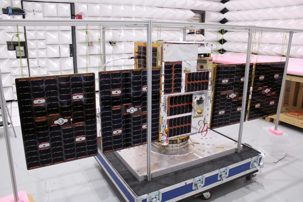
The U.S. Naval Research Laboratory (NRL) has successfully launched the GNSS Orbiting Situational Awareness Sensor (GOSAS), one of three advanced experimental payloads.
GOSAS was aboard the Space Test Program’s (STP) Satellite-7, which launched at 4:33 a.m. PDT on April 7 from VandenbergU.S. Space Force (USSF) Base, California.
The other payloads are the Lasersheet Anomaly Resolution andDebris Observation (LARADO) instrument and the Gadolinium Aluminum Gallium Garnet (GAGG) Radiation Instrument (GARI-1C).
GOSAS will improve the reliability of navigation and communication systems for warfighters.
“The GOSAS is a CubeSat-compatible, programmable dual GPS receiver designed to characterize the orbital GNSS environment and produce high-quality ionospheric space weather products,” said Scott Budzien, PhD, NRL research physicist and GOSAS principal investigator. “Understanding and predicting space weather is critical for ensuring the accuracy of GPS and the integrity of military communications.”
GOSAS is a follow-on to the NRL experiment GROUP-C (GPS Radio Occultation and Ultraviolet Photometry-Collocated) experiment on the International Space Station that took place 2017-2023 and serendipitously detected GPS ground interference.
GOSAS originated in 2020 with the mission of increasing GPS accuracy for the warfighter.
“Seen & Heard” is a monthly feature of GPS World magazine, traveling the world to capture interesting and unusual news stories involving the GNSS/PNT industry.
Photo: spxChrome/E+/Getty Images
Citizens Clean Up Coasts
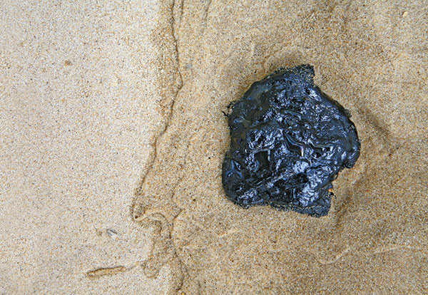
Two citizen groups are taking action with the help of Esri ArcGIS mapping tools. North Coast World Earth uses Esri Ireland’s platform on the Northern Irish coast to record litter hotspots and engage with local communities. The volunteer group has collected nearly 3 tons of litter. In California, the Surfrider Foundation employed ArcGIS Hub to streamline cleanup operations after a major oil spill off Huntington Beach in October 2021. Citizens submitted more than 1,100 reports using the ArcGIS QuickCapture photo app to share the date, time and coordinates of toxic tar balls on beaches from Oxnard to San Diego.
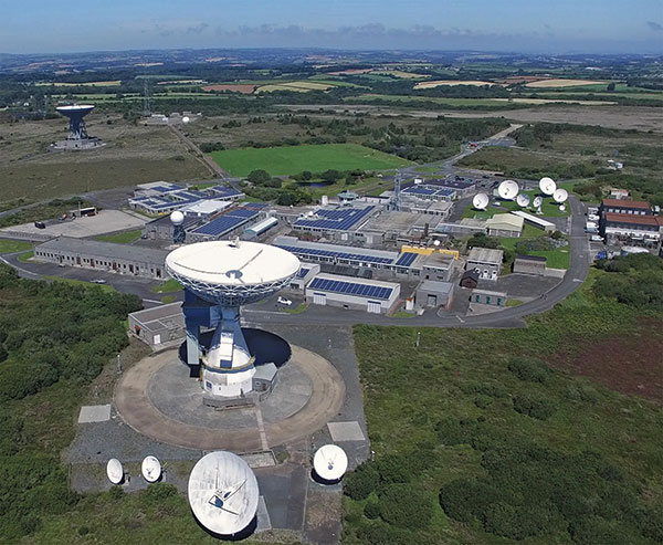
A new series of tests will assess whether the United Kingdom satellite-based augmentation system (UKSBAS) for GNSS can develop into full operational capability to support safety-critical applications post-Brexit. Inmarsat, Goonhilly Earth Station and GMV NSL are conducting the UK Space Agency-funded tests. The signal is now stable and operational, enabling ongoing testing and validation by industry, regulators and users. If successful, UKSBAS will enable assessment of more precise, resilient and high-integrity navigation for maritime and aviation users in UK waters and airspace.
Image: ESA
Smart GNSS Monitoring
More than 11,000 people around Europe and the world have turned their smartphones into GNSS monitoring tools by downloading the CAMALIOT app, so far delivering more than 53 billion measurements of meteorology and space weather patterns to researchers, reports the European Space Agency (ESA). ESA asks CAMALIOT volunteers to leave their smartphones by a window each night with GNSS on. The phones record small variations in satellite signals, gathering data for machine-learning analysis. More than 50 smartphone models with dual-frequency receivers can use the app.
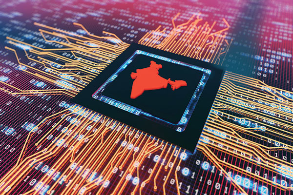
Indian Prime Minister Narendra Modi gave his stamp of approval to his country’s indigenous NavIC during a drone festival May 27. Despite that, the Indian Army purchased three GNSS receivers from Baidu, a Chinese company, instead of relying on home-grown companies as the contract required, reports The New Indian Express. The receivers are for survey stations of the College of Military Engineering. A few Indian manufacturers objected to the purchase, the newspaper said, but their concerns were brushed aside by the Department of Military Affairs.
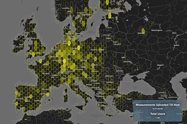
This graphic represents measurements uploaded via the CAMALIOT app by thousands of volunteers. (Image: ESA)
More than 11,000 people around Europe and the world have turned their smartphones into GNSS monitoring tools by downloading the CAMALIOT app, so far delivering more than 53 billion measurements of meteorology and space weather patterns to researchers, according to the European Space Agency (ESA).
ESA asks CAMALIOT volunteers to leave their smartphones by a window each night with GNSS on. The phones record small variations in satellite signals, gathering data for machine-learning analysis. More than 50 smartphone models with dual-frequency receivers can use the app.
CAMALIOT was developed through ESA’s Navigation Innovation and Support Programme (NAVISP) with the support of the agency’s Navigation Science Office through its GNSS Science Support Centre. The combination of GNSS data, smartphone access and machine learning in support of science is a priority research line of ESA’s Navigation Science Office.
GNSS signals undergo scintillation as they pass through irregular plasma patches in the ionosphere. This electrically charged upper atmospheric layer is continuously changing, influenced by solar activity, geomagnetic conditions and the local time of day. Dual-frequency GNSS receivers can compensate for this effect by comparing their two frequencies.
As these signals head to Earth, they are also modified by the amount of water vapor in the lower atmosphere, helping to forecast rainfall in particular.
“Fixed satnav stations already monitor these effects, but these smartphone-based measurements are boosting our coverage hugely. We’re very gratified by all the support we’ve received,” said Vicente Navarro, ESA navigation engineer. ”These results will then undergo a Big Data machine-learning analysis, seeking out previously unseen patterns in both Earth and space weather.”
Formally known as the Application of Machine Learning Technology for GNSS IoT Data Fusion project, CAMALIOT is run by a consortium led by ETH Zurich in collaboration with the International Institute for Applied Systems Analysis.
The largest source of error in GNSS positioning is the delay suffered by the signals as they pass through the ionosphere traveling from the satellites in orbit to receivers on or near Earth’s surface. That is because the ionosphere is full of free electrons stripped from atoms and molecules by ionization and this plasma refracts the signals, changing their speed. Normally, models compensate for this. However, geomagnetic storms wreak havoc on the free electrons in the ionosphere, making it difficult to accurately determine the signal delay.
That is why space weather matters for GNSS and for the myriad human activities that have come to depend on it.
So, here’s the good news. “On a scale of one to five, the geomagnetic storm on April 14 was a three,” Bill Murtagh told me. Murtagh is the Program Coordinator and Space Weather Forecaster at the Space Weather Prediction Center (SWPC) of the National Oceanic and Atmospheric Administration (NOAA). He was referring to the third rung of NOAA’s space weather scales, which were introduced to communicate to the public the current and future space weather conditions and their possible effects on people and systems.
NOAA has three space weather scales, one each for geomagnetic storms (G scale), solar radiation storms (S scale), and radio blackouts (R scale). The steps on the scales, ranging from “minor” to “extreme,” are analogous to those NOAA uses to classify hurricanes, tornadoes and earthquakes. They describe the environmental disturbances for each of these events and list their possible effects at each level.
Solar activity runs in 11-year cycles. A G5 event happens two or three times per cycle, and the last one was in October 2003, Murtagh told me. “I can only remember a handful of occasions over the past 20 years when ionospheric activity has significantly impacted users,” told me Gavin Schrock, PLS, manager of the Washington State Reference Network, a regional cooperative of GPS reference stations and data. According to Rick Hamilton, the GPS Information Analysis Team Lead at the U.S. Coast Guard Navigation Center, it “did not receive any reports of interference related to the geostorm” and “there was no significant increase in reports that we might attribute to geomagnetic activity.”
Now, the bad news. We are heading for a maximum in solar activity, expected to occur in 2025. The Sun is “already quite active,” Murtagh pointed out, and recently there has been an increase in the number of R1 and R2 storms. Solar coronal mass ejections (CMEs), which launch plasma and magnetic fields into space, also have become more frequent. When a CME hits the Earth, its collision with the Earth’s magnetic field causes a geomagnetic storm.
So, the GNSS constellations and the GNSS industry should be preparing now. Fortunately, improvements in GNSS software and receiver technology, plus corrections and integrity information and the much larger number of satellites, make us better prepared than we were during the last cycle. On the other hand, the stakes also are much larger, due to our ever-greater reliance on GNSS.
As a sailor, I rely on NOAA nautical charts and marine weather forecasts. GNSS users can thank NOAA for its space weather forecasts.
A PNT expert suggested that my piece titled “Opposite and Complementary: eLoran is part of the solution to GNSS vulnerability” in our November 2021 issue could be augmented with information not currently available on the proposed eLoran capability. This expert also questioned my statement that eLoran “does not have any common failure modes with GNSS” and pointed to potential common threats such as from cyberattacks, physical attacks, and space weather.
Matteo Luccio
I welcome such feedback on the contents of these pages — and agree that in this case some hard questions are warranted. So, in the interest of further exploring the use of eLoran, I pose some questions, hoping that its advocates will provide answers. I know that at least some of them will not shy away from this challenge.
Please note that I wish to keep the discussion on positioning, not the easier question of timing, because that was the primary focus of my article. I also wish to address long-term outages (weeks or months), which would have a greater impact on the United States.
Some of these questions have been addressed, at least in part, in various studies and proposals, most of them now more than a decade old. So, it would be helpful to update those answers and consolidate them in the pages of this magazine.
1. Accuracy specifics. While my November article stated that eLoran would have a two-dimensional accuracy of “better than 20 meters, and in many cases, better than 10 meters,” is that RMS, 95%, or some other statistic?
2. Performance standard. GPS provides a commitment to users in a published performance standard. What specific measures of positioning accuracy, integrity and continuity would you recommend the proposed eLoran system be committed to provide (using the architecture described in the answer to Question 6)?
3. Coverage. Would you recommend this eLoran positioning performance hold for the entire United States (including Alaska, Hawaii, Puerto Rico and other territories), only for the “lower 48” states, or only parts of these 48 states?
4. Current users. By number of users, the predominant common current civil uses of GNSS for positioning are consumer devices (mostly cellphones). By contribution to the U.S. economy, the predominant uses are high-precision applications. For what fraction of these uses would eLoran positioning be adequate? Could an eLoran receiver and antenna fit in today’s consumer devices?
5. Future uses. Emerging civil uses of GPS for positioning include autonomous ground and air vehicles, navigation to space and in space, and lane-accurate car navigation. Which of these could be served by eLoran?
6. Architecture. To maintain accuracy during a prolonged GPS outage, eLoran would require reference stations to calibrate time-varying propagation errors, as well as a certain number of transmitters for good nationwide geometry and for redundancy, ensuring service even if a transmitter is attacked or is taken off-line for maintenance. What architecture would you recommend to achieve this?
7. Infrastructure cost. What would be the cost of installing the required transmitters, power supplies, reference stations, communication links and control system for the architecture described in the answer to Question 6? Can you reference a recent and independent estimate? To a ballpark figure, what cost fixed-price contract would you accept to implement it? Similarly, what would be the annual costs for operating and maintaining this infrastructure?
8. Impact. eLoran transmitters are large and high-power. Providing positioning across the United States could require building some of them from scratch or significantly reconstructing old Loran sites. What issues — such as environmental, aviation safety and security — would this raise, and how would you recommend they be addressed?
9. Receivers. Assuming all the above were achieved, it would accomplish nothing unless eLoran receivers were widely purchased, installed and used. How much would that cost? Who would pay? Should we assume that “if we build it, they will come”?
10. Alternatives. Given the widespread development of other positioning technologies over the past decade, much has changed since the earlier recommendations for eLoran. How do we know that eLoran is the right investment — or even a needed part of the solution or needed system in a system of systems — for the future of U.S. PNT?
Common threats to GNSS and eLoran could include the following:
1. Cyber attacks. Given that GPS’s OCX is said to be the most cybersecure system built by the U.S. Department of Defense, how would eLoran’s control system be even more cybersecure than OCX, to avoid a common cyber-vulnerability?
2. Physical attacks. Given concerns about possible physical attacks on GPS satellites, which move at multiple km/sec 20,000 km from Earth, would it not be easier to physically attack eLoran transmitters, which are stationary, terrestrial, in remote locations, and hundreds of feet tall and require massive power sources?
3. Space weather. GPS is potentially vulnerable to severe space weather that could damage satellites or temporarily hinder signal propagation from space to Earth. However, severe space weather could also damage the power grid upon which megawatt eLoran transmitters rely. How would eLoran service be protected from the effects of severe space weather, such as a Carrington Event?
Send me your thoughts at the e-mail address below, with “eLoran” in the subject line.
A new data source to help scientists better understand the ionosphere and its potential impact on communications and positioning, navigation and timing (PNT) is now available to the public.
The data, which was collected by sensors on GPS satellites in 2018, was released through a collaborative effort by Los Alamos National Laboratory and the National Oceanic and Atmospheric Administration (NOAA).
“Radio signals from satellite or ground-based transmitters can travel through the ionosphere or bounce off of it, so ionospheric conditions have the potential to disrupt communications depending on the density of electrons,” said Erin Lay, a remote-sensing scientist at Los Alamos who was a technical lead on the project. “This new set of data will help us better model and predict the behavior of the ionosphere and possibly improve the reliability of our communications and positioning, navigation, and timing services, which are critical for both everyday life and national security.”
The ionosphere is the boundary between Earth’s atmosphere and space, stretching 40 to 250 miles above Earth’s surface. It is composed of tenuous atmosphere and charged particles (ions and electrons) that interact with traversing radio waves. The behavior of the ionosphere reacts to weather on Earth, such as thunderstorms, wind, and hurricanes, as well as space weather created by solar winds impacting Earth’s magnetic field.
“NOAA’s Space Weather Prediction Center (SWPC) serves a huge customer base interested in space weather effects on communications and GPS-reliant technologies,” said Bill Murtagh, program coordinator at SWPC. “We expect access to these Los Alamos data sets to improve the development, validation, and testing of models used at SWPC for characterizing and forecasting ionospheric disturbances.”
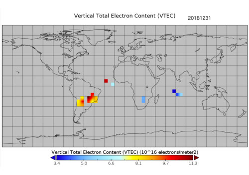
Preview graphic. (Image: NOAA)
The new data comes from unique measurements of lightning events, each of which produces a flash of radio waves that gets dispersed through the ionosphere before it is detected on satellite receivers. Each measured flash provides a snapshot of the ionospheric conditions at that instant, and many lightning measurements accumulated over time provide a unique view of ionospheric weather. This is the first-ever global set of ionospheric electron density data to use a naturally occurring source phenomena.
Before this release, the data available to feed ionosphere models was primarily from arrays of ground-based receivers, which are limited because they only monitor fixed locations. According to Lay, “the new data is gathered from lightning that happens all over the world and will give scientists the opportunity to study the ionosphere in ways previously not possible.”
The release of underutilized data sets was a priority established in the 2019 National Space Weather Strategy and Action Plan. Los Alamos processed the data from its radio-frequency sensors that are onboard GPS satellites and used for nuclear treaty monitoring, and then worked with a government interagency group, called the Space Weather Operations, Research and Mitigation (SWORM), to facilitate public release.
NOAA’s National Centers for Environmental Information will host the data on existing sites that serve terrestrial weather and space weather resources.
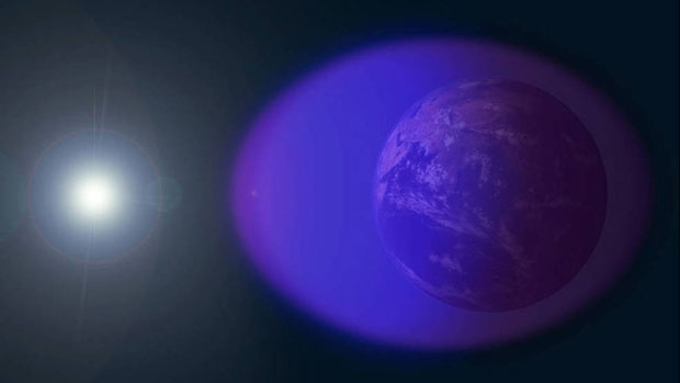
The ionosphere is shown in purple and not-to-scale in this image. (Image: NASA’s Goddard Space Flight Center/Duberstein)
The Institute of Navigation’s (ION) Satellite Division presented several annual awards Sept. 25 during the ION GNSS+ Virtual Conference.
Morton Honored with Kepler Award
Y. Jade Morton received the Johannes Kepler Award for advances in scientific and navigation receiver technology, automated data collection, robust carrier phase tracking, remote sensing, and profound impact as an educator and author.
Morton is the director of the Colorado Center for Astrodynamics Research at the University of Colorado, Boulder ,where she mentors students, faculty, staff and an ever-expanding international network of collaborators throughout the world. She is a prolific author with more than 270 publications. She was awarded her Ph.D. in Electrical Engineering at Pennsylvania State University. She has also authored articles for GPS World.
Receiver Technology Pioneer. Morton has made pioneering contributions to the advancement of GNSS receiver technology and utilization of these enhanced capabilities for scientific discovery. Her work brings together scientific rigor with state-of-the-art engineering innovations to simultaneously improve PNT, while revealing remarkable new applications for GNSS.
Morton’s lab-developed event-driven GNSS data acquisition systems (EDAS), designed to capture severe space weather and ionosphere disturbances of GNSS signals, which could not be handled by existing GNSS monitoring receivers. Her lab designed and built remotely-configurable, multi-GNSS, multi-band, SDR hardware using off-the-shelf components; and developed software including machine-learning algorithms for automatic event detection to trigger raw data recording during these events.
Network established. Her lab deployed these receivers worldwide. The network has enabled unprecedented studies and forecasting of ionosphere/space weather phenomena, detection of satellite oscillator anomalies, and development of advanced GNSS receivers for navigation and remote sensing under challenging conditions.
Morton’s group has made groundbreaking advances in GNSS carrier-phase processing and established theoretical performance bounds. Her group developed optimal carrier tracking loop architectures and implementations, and successfully applied the techniques to processing signals experiencing strong ionospheric scintillation for ionosphere and space weather research; radio-occultation signals traversing moist lower troposphere for weather and climate modeling; weak coherent reflected signals from ocean, land, and sea ice for precision altimetry applications; and navigation in urban canyons and on high dynamic platforms.
Morton is an expert on space weather and ionosphere monitoring. Her research findings range from climatology and morphology of ionospheric plasma irregularities to spatial, temporal and frequency domain characteristics; cause-effect relationships between solar-geomagnetic activities and GNSS signal disturbances; and radio wave propagation theory and simulation. The studies, based on data from her GNSS networks, magnetometers, radar and satellite-based measurements, cover the globe from the arctic to the equator and span an entire solar cycle.
Volunteer service. Morton has served numerous organizations with thousands of hours of volunteer service including organizing each of the ION’s large technical conferences and leading over 10 student teams participating in ION’s autonomous lawn mower and snowplow competitions, is credited as one of the co-organizing founders of the ION’s Pacific PNT conference, has served as the ION Satellite Division Chair and is the current ION President. Dr. Morton is a past recipient of the IEEE Kershner Award and the ION’s Burka and Thurlow Awards. She is a Fellow of the ION, RIN and the IEEE.
The Johannes Kepler Award recognizes and honors an individual for sustained and significant contributions to the development of satellite navigation. It is the highest honor bestowed by the ION’s Satellite Division.
Kimia Shamaei Honored with Parkinson Award
ION’s Satellite Division presented Kimia Shamaei with its Bradford W. Parkinson Award Sept. 25 for her thesis, “Exploiting Cellular Signals for Navigation: 4G to 5G.”
The Bradford W. Parkinson Award is awarded annually to an outstanding graduate student in GNSS. The award, which honors Dr. Parkinson for his leadership in establishing both the U.S. Global Positioning System and the Satellite Division of the ION, includes a personalized plaque and a $2,500 honorarium.
Any ION member who is a graduate student completing a degree program with an emphasis in GNSS technology, applications, or policy is eligible for the award. ION thanks the altruistic experts who served on this year’s selection committee.
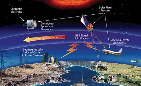
The effects of space weather on critical Earth systems. (Image: NASA)
The United States Congress has passed bipartisan legislation to address how the government deals with threats posed by emissions from the Sun to critical infrastructure such as GPS.
The Promoting Research and Observations of Space Weather to Improve the Forecasting of Tomorrow (PROSWIFT) Act S.881 now awaits signature by the president.
The bill sets forth provisions to improve the ability of the United States to forecast space weather events and mitigate its effects.
It provides statutory authority for the National Science and Technology Council’s Space Weather Operations, Research, and Mitigation Working Group, which coordinates executive branch efforts to understand, prepare, coordinate, and plan for space weather.
The bill directs the Office of Science and Technology Policy, National Oceanic and Atmospheric Administration (NOAA), National Science Foundation, Air Force, Navy, National Aeronautics and Space Administration (NASA), National Security Council, and Federal Aviation Administration (FAA) to carry out specified space weather activities.
The legislation
assigns roles and responsibilities to agencies involved in space weather research and forecasting
ensures agency coordination to better predict severe space weather events and mitigate impacts
calls for coordination between the government and the non-governmental space weather community including academia, the commercial sector and international partners.
Senators Gary Peters (D-MI) and Cory Gardner (R-CO) introduced the first version of the bill in 2016 and a successor passed the Senate in 2017. Reps. Ed Perlmutter (D-CO) and Mo Brooks (R-AL) shepherded it through the House, which passed it Sept. 16.
The U.S. House Committee on Science, Space and Technology has approved legislation to coordinate federal government space weather research. Included in the bill is a finding that space weather adversely affects space-based position, navigation and timing (PNT).
‘‘The effects of severe space weatheron the electric power grid, satellites and satellite communications and information, aviationoperations, astronauts living and working in space, and space-based position, navigation, and timing systems could have significant societal, economic, national security and health impacts.”
If passed, the bill would mandate coordination of government space weather forecasting and related operations, with input from academia, international groups and commercial firms affected by space weather.
The Promoting Research and Observations of Space Weather to Improve the Forecasting of Tomorrow (PROSWIFT) Act was introduced in November by Democrat Ed Perlmutter of Colorado and Republican Mo Brooks of Alabama, reports Space News. Similar legislation, the Space Weather Research and Forecasting Act, was approved in April by the Senate Commerce, Science and Transportation Committee.
PROSWIFT calls for the National Science and Technology Council to establish an interagency working group on space weather that includes the National Oceanic and Atmospheric Administration (NOAA), NASA, the National Science Foundation, Defense Department and Interior Department. It directs members of the interagency working group to collaborate with the international community, academia and the commercial space weather sector.
PROSWIFT also tasks NOAA with establishing a space weather advisory group with members representing academia, the commercial space weather sector and space weather data customers.
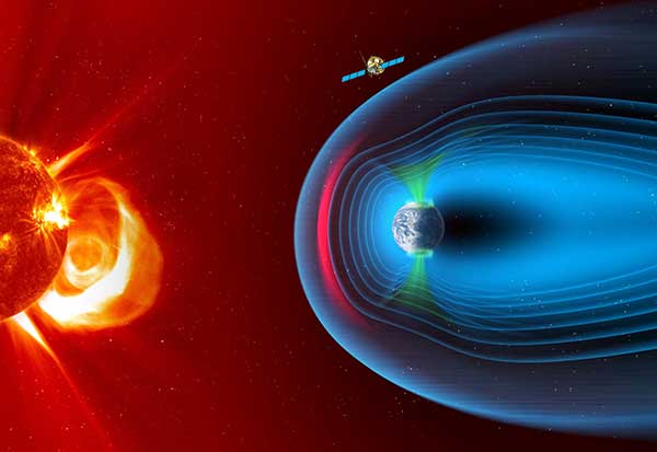
The European Space Agency has chosen Airbus to build the European component of the SMILE (Solar wind Magnetosphere Ionosphere Link Explorer) satellite.
SMILE will be the first joint satellite mission between the European Space Agency (ESA) and the Chinese Academy of Sciences (CAS), following on from the success of the Double Star/Tan Ce mission which flew between 2003 and 2008.
The objective of SMILE is to study and understand space weather. Specifically, it will look at the physics behind continuous interaction between particles in the solar wind and Earth’s magnetosphere, the magnetic shield that protects the existence of life in our planet.
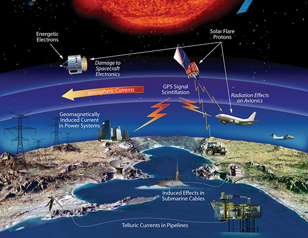
Space weather can interfere with GNSS signals.
The mission is now entering a four-year period of manufacturing, testing and integration of the payload module and the platform. In launch configuration, these two components will form a 3.15-meter-high stack.
The spacecraft will have a mass of 2,200 kg and will travel in a highly elliptical orbit around the Earth. Its perigee will be at a distance of 5,000 km (from where it will download data to the Troll ground station in Antarctica and the CAS ground station in Sanya, China), while the apogee will be as far as 121,000 km (almost one third the distance to the Moon). At this vantage point the satellite will have a prolonged view of the Earth’s northern polar regions, to enable the boundary of the Earth’s magnetic field and the Northern Lights, or aurora borealis, to be imaged.
Payload in Madrid, platform in Shanghai. The payload module will be built at the Airbus site in Madrid, where the instruments will be integrated. The platform will be built in Shanghai. Both, the payload module and the platform will be integrated and tested at ESA’s European Space Research and Technology Centre facilities by a multinational team.
The science payload consists of four instruments:
The Soft X-ray Imager will obtain unique measurements of the regions where the solar wind impacts the magnetosphere.
The Ultra-Violet Imager will study the global distribution of the auroras.
The Light Ion Analyser will measure the energetic particles in the solar wind.
The Magnetometer will assess changes in the local magnetic field.
“Today, we are able to predict the weather on Earth; now it’s SMILE’s turn to help us understand space weather around the Earth and who knows? Probably one day, we will have enough data to be able to forecast dangerous solar storms that could disrupt our systems in space and on the ground,” said Fernando Varela, head of Airbus Space Systems in Spain. “We thank the Spanish Administration for their decisive and continued support to scientific missions.”
Other ESA missions, built by Airbus, such as Cluster that studied the Earth’s magnetosphere, and SOHO that studied the Sun, have already improved understanding of space weather.
Under the current plans, the spacecraft will be launched by a European Vega-C or Ariane 62 rocket in 2023.
At the end of 2016, the DemoGRAPE consortium observed, for the first time ever, ionospheric scintillations on Galileo signals in Antarctica, using Septentrio’s PolaRx5S GNSS reference receiver.
DemoGRAPE investigates improvement of high-precision satellite positioning with a view to developing scientific and technological applications in Antarctica. At higher latitudes, GNSS signal degradation due to ionospheric activity is more pronounced.
Septentrio’s PolaRx5S reference receiver.
The more precise phase-based positioning modes are particularly vulnerable to ionosphere disturbance such as scintillations. Elevated ionospheric activity can cause a loss of precise-positioning mode or, in more extreme cases, a total loss of signal lock.
Monitoring the movement and evolution of ice shelves and glaciers as well as geodetic prospecting require highly precise positioning. Besides this scientific interest, accurate positioning is important from a safety standpoint.
When visibility is limited and travel is restricted, designated routes between remote locations have to be strictly followed to avoid dangers such as falling into a crevasse during a snowstorm.
DEMOGrape is an international project lead by Istituto Nazionale di Geofisica e Vulcanologia (INGV), Rome, Italy in partnership with the Politecnico di Torino, the South African National Space Agency (SANSA) and the National Institute for Space Research, São Paulo, Brazil (INPE).
Septentrio’s PolaRx5S is the benchmark for GNSS space weather applications. It provides data for scintillation analysis (I&Q correlations, phase, code and carrier-to-noise) at up to 100 Hz for all GNSS L-band frequencies. SBF, RINEX and BINEX data logging is possible on both a built-in 16 GB memory and on an externally connected device. Up to 24 independent data archives can be defined. Logged data can be accessed via the web UI server or automatically pushed to a FTP server.
“We are really very happy of the fruitful collaboration with Septentrio colleagues that supported our measurements in the extreme environment of Antarctica,” the team said in an article published in Space Weather. “The first Galileo scintillations observed in the DemoGRAPE sites are attracting the attention of space weather communities, also beyond the European borders.” (Alfonsi, L., P. J. Cilliers, V. Romano, I. Hunstad, E. Correia, N. Linty, Fabio Dovis et al. “First Observations of GNSS Ionospheric Scintillations From DemoGRAPE Project.” Space Weather14, no. 10 (2016): 704-709).
“We are really proud to have enabled our colleagues and friends from INGV and the DEMOGrape consortium to make this first of a kind scintillation measurement on the Galileo signals,” said Bruno Bougard, director of R&D at Septentrio. “Galileo added value on high-precision application resides in its ability to increase the position availability and reliability compared to traditional GPS+GLONASS systems. Demonstrating its resilience to scintillation is key for operations at high latitudes.”
Today, more than 16 years of space-weather data is publicly available for the first time in history. The data comes from space-weather sensors on board the nation’s GPS satellites.
The newly available data gives researchers a treasure trove of measurements they can use to better understand how space weather works and how best to protect critical infrastructure, such as the nation’s satellites, aircraft, communications networks, navigation systems and electric power grid.
A feature article providing an overview of the data that have been released was published today in Space Weather, a journal of the American Geophysical Union.
“Space-weather monitoring instruments developed at Los Alamos have been fielded on GPS satellites for decades,” said Marc Kippen, program manager at Los Alamos National Laboratory in New Mexico, which developed the space weather sensors. “Today, 23 of the nation’s more than 30 on-orbit GPS satellites carry these instruments. When you multiply the number of satellites collecting data with the number of years they’ve been doing it, it totals more than 167 satellite years. It’s really an unprecedented amount of information.”
An image illustrating the six orbital planes in which GPS satellites (“navigational satellites,” or ns) fly around Earth. This configuration shows the orbits just before the start of this solar cycle’s biggest geomagnetic storm, which occurred on March 17, 2015. The darkest orbital lines indicate the position of the satellites in that moment; the lightest lines indicate where they were 12 hours prior. (Credit: Los Alamos National Laboratory)
Extreme space-weather events have the potential to significantly threaten safety and property on Earth, in the air, and in space.
For example, the hazard of increased radiation exposure from charged particles released during a large solar flare could require that flights be diverted away from a polar route.
Similarly, sudden bursts of plasma and magnetic field structures (coronal mass ejections, or CMEs) from the sun’s atmosphere and high-speed solar wind could significantly disable large portions of the electric power grid. The resulting cascading failures could disturb air traffic control, disrupt the water supply, and interfere with life-saving medical devices.
In space, the charged particles measured by the Los Alamos-GPS sensors are the primary limit on how long a satellite can operate in space before succumbing to the damaging effects of radiation.
In extreme events those particles can cause malfunction of satellites or even catastrophic failure of entire satellite systems.
For example, in April 2010, a large magnetic disturbance resulted in a communications failure, causing a satellite to uncontrollably drift in space and presenting a hazard to nearby satellites.
Currently, scientists are unable to predict when these extreme events will occur, how strong they will be, or how severe the effects will be. The release of Los Alamos-GPS data enables new studies that will help answer these questions.
The Los Alamos-GPS sensors continuously measure the energy and intensity of charged particles, mainly electrons and protons, energized and trapped in Earth’s magnetic field. These trapped particles form the Van Allen radiation belts, which are highly dynamic—varying on time scales from minutes to decades. From GPS orbit (roughly 12,600 miles above Earth), satellite-borne sensors probe the largest radiation belt—consisting mainly of energetic electrons.
Each of the 23 sensors in the current GPS constellation makes detailed measurements of the belts every six hours. Together the sensors provide 92 complete measurements of the belts every day. The newly released measurements constitute a nearly continuous global record of the variability in this radiation belt for the past 16 years, including how it responds to solar storms. The data provides an invaluable record for understanding radiation-belt variability that is key to developing effective space-weather forecasting models.
Los Alamos has been anticipating greater awareness of the nation’s vulnerability to space weather since the 1990s, when it began aligning its space-weather research activities with its critical-infrastructure program. “This led to an awareness that we could expand the utility of our space-weather data to programs beyond the specific requirements they were designed for,” said Kippen, a co-author of the feature article.
The public release of GPS energetic-particle data was conducted under the terms of an October 2016 White House Executive Order. It culminates years of work between the Office of Science and Technology Policy and the National Security Council to coordinate interagency efforts aimed at improved understanding, prediction and preparedness for potentially devastating space-weather events. The specific goal of releasing space-weather data from national-security assets such as GPS satellites is to enable broad scientific community engagement in enhancing space-weather model validation and improvements in space-weather forecasting and situational awareness.
“The US DoD, the Office of Science Technology Policy, and the broader space weather enterprise deserve our support and thanks for this data release,” Delores Knipp, editor-in-chief of Space Weather, wrote in a blog post accompanying the feature article. “This cache of data will likely drive fundamental new developments in geospace research. The data release should be emulated by other nations as they invest in space-based global and regional navigation satellite systems.”