Tag: Surrey Satellite Technology Ltd.

  • The Moon: Where no satnav has gone before

    The Moon: Where no satnav has gone before

    News from the European Space Agency

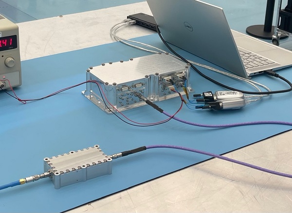
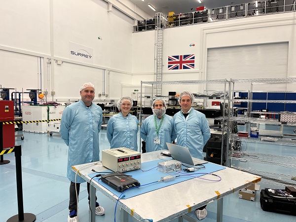
    The test version of a unique satellite navigation receiver has been delivered for integration testing on the Lunar Pathfinder spacecraft.

    The NaviMoon satnav receiver is designed to perform the farthest ever positioning fix from Earth, employing signals that will be millions of times fainter than those used by smartphones or cars on Earth.

    The NaviMoon receiver and low-noise amplifier. (Photo: SSTL)
    The NaviMoon receiver and low-noise amplifier. (Photo: SSTL)

    “This engineering model of our NaviMoon receiver is the very first piece of hardware to be produced in the context of ESA’s Moonlight initiative, to develop dedicated telecommunications and navigation services for the Moon,” explained Javier Ventura-Traveset, head of ESA’s Navigation Science Office and manager of ESA lunar navigation activities.

    “It will be flown aboard the Lunar Pathfinder mission into orbit around the Moon, from where it will perform the furthest satellite navigation positioning fix ever made, at more than 400,000 kilometers away to an accuracy of less than 100 meters,” Ventura-Traveset said. “This represents an extraordinary engineering challenge, because at such a distance the faint Galileo and GPS signals it uses will be barely distinguishable from background noise. This demonstration will imply a true change of paradigm for lunar orbiting navigation.”

    Relaying signals for multiple lunar missions
    Relaying signals for multiple lunar missions

    The washing-machine-sized Lunar Pathfinder is being built as a commercial mission by Surrey Satellite Technology Ltd. (SSTL), in the United Kingdom. ESA is funding guest payloads for it, including the 1.4-kg NaviMoon receiver that will be accommodated beside the spacecraft’s main X-band transmitter that links it with Earth.

    “Receiving physical hardware for a mission is always fantastic,” said Lily Forward, SSTL system engineer. “This engineering model receiver will be integrated into our FlatSat Test Bed version of the mission to test that all our systems communicate and work together properly, ahead of receiving the flight-model receiver and antenna later this year.”

    Lunar Pathfinder will relay communications from orbital and surface missions
    Lunar Pathfinder will relay communications from orbital and surface missions

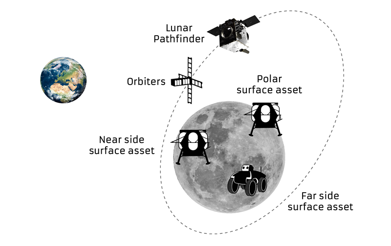
    This will be SSTL’s first full-fledged mission beyond Earth, she added. “Laying the foundations for numerous scientific missions that will come after it, Lunar Pathfinder is a communications relay satellite, intended to serve assets on both the nearside and farside, orbiting in an elliptical lunar frozen orbit for prolonged coverage over the South Pole — a particular focus for future exploration. Then, during regular intervals, we will orient the spacecraft towards Earth to test out the NaviMoon receiver.”

    Satnav position fixes from the receiver will be compared with conventional radio ranging carried out using Lunar Pathfinder’s X-band transmitter as well as laser ranging performed using a retroreflector contributed by NASA and developed by the KBR company.

    Laser ranging station
    Laser ranging station

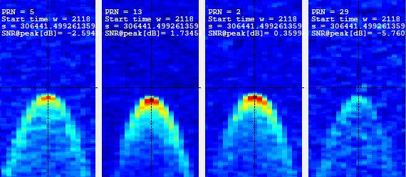
    “This will be the first time these three ranging techniques will be used together in deep space,” explained ESA navigation engineer Pietro Giordano. “There is a long heritage of lunar laser ranging, going back to the Apollo missions, and the retroreflector we are using is an evolution from NASA’s Lunar Reconnaissance Orbiter. The combination of all ranging techniques will improve the orbit estimation further, potentially beyond what radio ranging can achieve.

    “In principle, this could mean that future missions could navigate themselves to the Moon autonomously using satellite navigation signals alone with no help from the ground.”


    Galileo 'side lobe' signals
    Galileo ‘side lobe’ signals

    Finding ultra-faint satnav signals

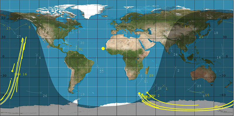
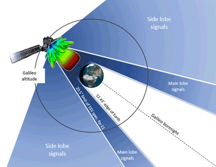
    The satnav signals employed here on Earth are already vanishingly faint, equivalent to a single pair of car headlights shining all across Europe. By the time these signals reach the Moon, they have crossed distances of more than 20 times further, attenuating through space like ripples from a stone splashed in water.

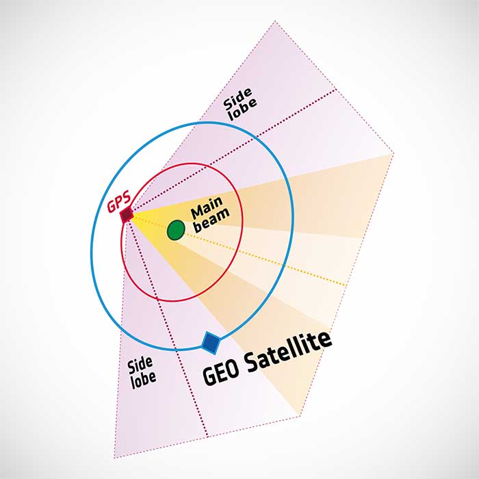
    “Adding to the difficulty, the satnav constellations are not designed to transmit up into space, but to keep their antennas facing Earth,” Giordano said. “So we are reliant on much weaker side-lobe signals, like light spilling from the sides of a flashlight. To be able to make use of these signals, we turned to a specialist in space-based satellite navigation, whose signal-processing techniques have really proven the magic ingredient.”

    Testing the NaviMoon receiver and Low Noise Amplifier engineering models at SSTL ahead of integration testing. The flight models of the receiver and amplifier will be delivered later in 2022. (Photo: SSTL)
    Testing the NaviMoon receiver and Low Noise Amplifier engineering models at SSTL ahead of integration testing. The flight models of the receiver and amplifier will be delivered later in 2022. (Photo: SSTL)

    SpacePNT, based in Switzerland, oversaw the NaviMoon receiver design.  “We began working on the idea of lunar-distance satnav positioning back in 2013 as something of a scientific challenge,” said Cyril Botteron, company head.

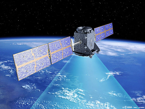
    “The combination of Galileo dual-frequency signals with those of the existing GPS satellites is what started to make it feasible,” Botteron said. “Although, along with the extreme sensitivity that is demanded, the other big problem is that from the Moon all the satnav satellites are in the same narrow geometry of sky around Earth, periodically rotating out of view.”

    Lunar navigation satellites will ultimately help guide Moon landings, such as with the European Large Logistic Lander. (Image: ESA)
    Lunar navigation satellites will ultimately help guide Moon landings, such as with the European Large Logistic Lander. (Image: ESA)

    The solution that SpacePNT came up with leverages more than half a century of lunar exploration. The company installed a dynamic software model of all the forces acting upon the satellite into the receiver, including the gravitational influences of the Moon, Earth, Sun and planets as well as the very slight push from sunlight itself — solar radiation pressure — along with factors such as clock error and the radio signal direction.

    “As we experience a given acceleration the receiver can judge it is most probably at one particular point in its orbit,” Botteron said. “Usually a satnav receiver needs signals from four satellites to fix its position, but with this approach, less than four signals is still enough to obtain useful information, constraining the model to minimize any error drift.”

    European Engineering & Consultancy (EECL) in the UK was assigned the task of turning SpacePNT’s design into fully tested hardware, and also designed the crucial low-noise amplifier that sifts through noise to boost usable signals.

  • Galileo prototype GIOVE-A switched off after 16 years in orbit

    Galileo prototype GIOVE-A switched off after 16 years in orbit

    Artist's rendering of GIOVE-A in orbit. (Image: ESA)
    Artist’s rendering of GIOVE-A in orbit. (Image: ESA)

    News from the European Space Agency

    Europe’s first prototype satellite for Galileo, GIOVE-A, has been formally decommissioned after 16 years of work in orbit. The GIOVE-A mission in 2005 secured Galileo’s radio frequencies for Europe, demonstrated key hardware, and probed the then-unknown radiation environment of medium-Earth orbit.

    “If not for GIOVE-A, the 26 Galileo satellites in orbit today would not exist,” said Paul Verhoef, ESA’s director of navigation. “Its speedy development and launch opened the way for our working constellation to follow.”

    ESA had begun designing Galileo at the turn of the century, and radio frequencies had been set aside for the new system by the International Telecommunications Union. But these frequency filings came with a deadline attached: the frequencies had to be used from orbit by mid-2006 or they would lapse.

    GIOVE-A was launched by Soyuz from Baikonur cosmodrome in Kazakhstan on Dec. 28, 2005. (Photo: ESA)
    GIOVE-A was launched by Soyuz from Baikonur cosmodrome in Kazakhstan on Dec. 28, 2005. (Photo: ESA)

    GIOVE-A Sped to Orbit

    Galileo In-Orbit Validation Element-A, or GIOVE-A, was produced at a breakneck pace to meet this deadline. Developed in the second half of 2003, the satellite was designed, built and tested before the end of 2005, and launched on Dec. 28 of that year.

    “At the time there was a lot of uncertainty: Would we make it or not?” recalled Javier Benedicto, head of the Galileo Project Department, ESA. “GIOVE-A transmitted its first Galileo signal-in-space on Jan. 21, 2006, meaning that Europe was formally in the navigation business.”

    That March, ESA formally confirmed it had brought the Galileo-related frequency filings into use, three months ahead of the official ITU deadline.

    Europe's first navigation satellite GIOVE-A, short for Galileo In-Orbit Validation Element-A, during flight preparation. (Photo: ESA)
    Europe’s first navigation satellite GIOVE-A, short for Galileo In-Orbit Validation Element-A, during flight preparation. (Photo: ESA)

    The mission also carried a prototype rubidium atomic clock — proving its functionality for the operational Galileo satellites that would follow — as well as a radiation instrument. Medium Earth orbit, 23,000 km altitude, was terra incognita at this point for European satellites, but it was known to possess enhanced radiation levels from the impinging of the outer band of Earth’s Van Allen radiation belts.

    A second Galileo prototype, GIOVE-B, followed in 2008, this time hosting a prototype passive hydrogen maser — the second type of atomic clock that Galileo relies on — along with an enhanced payload able to transmit for the first time the GPS-Galileo common signal.

    GIOVE-A Succeeded at New Mission

    Once the first Galileo satellites were in orbit and working well, ESA ended use of GIOVE-A in 2012. The satellite was placed in a graveyard orbit 100 km above the operational satellites’ orbits, as was GIOVE-B after its own four-year mission.

    Control of GIOVE-A passed to manufacturer Surrey Satellite Technology Ltd (SSTL) in the United Kingdom. GIOVE-A was then employed for various in-orbit experiments, including demonstrating the reception of satellite navigation signals from GPS satellites orbiting below it — based on spillover sidelobe reception from satellites on the other side of Earth.

    GPS satellites — like those of Galileo, Russia’s GLONASS or their Japanese, Chinese and Indian counterparts — aim their antennas directly at Earth. Any satellite orbiting above the GPS constellation can only hope to detect signals from over Earth’s far side, but the majority are blocked by the planet. For a position fix, a satnav receiver requires a minimum of four satellites to be visible, but this is most of the time not possible if based solely on front-facing signals. Instead, GIOVE-A has been able to make use of signals emitted sideways from GPS antennas, within what is known as "side lobes." Just like a flashlight, radio antennas shine energy to the side as well as directly forward. (Image: ESA)
    GIOVE-A was able to make use of signals emitted sideways from GPS antennas, within what is known as “side lobes.” (Image: ESA)

    This proof that satnav can be relied on further out into space means that satellites in geostationary orbit are making use of satnav for positioning. As a next step, ESA is planning to extend satnav coverage all the way to the Moon.

    The satellite also continued its radiation survey of medium-Earth orbit, acquiring a unique record extending across more than 10 years, analyzed by the Surrey Space Centre with ESA support. Multiple scientific papers have been written on these results, which encompass the “electron desert” of 2008-9 during the lowest levels of solar activity of the space era, followed by one of the largest electron storm events on record in April 2010.

    A new model of the outer Van Allen belt electron fluxes, MOBE-DIC, has been produced from this dataset, helping to guide future satellite designs.

    “Actually, the satellite itself is still operating well,” said Sarah Lawrence, SSTL. “The reason for ending the mission is software obsolescence in our control center. The decommissioning procedure involved transitioning the satellite to Earth-pointing mode, turning off the reaction wheels and setting the attitude and orbit control system to standby mode, before finally switching off the on-board computer and transmitter.”

    “GIOVE-A over-delivered on its original lifetime and mission goals – an inspiring and game-changing mission on so many levels,” said Martin Sweeting, SSTL executive chairman.

    SSTL went on to provide navigation payloads for operational Galileo satellites. Today, 26 Galileo satellites orbit the Earth. Galileo has become the world’s most precise satnav system, delivering meter-scale accuracy to more than 2.3 billion users around the globe.

    Two more Galileo satellites are being readied for launch Dec. 2.

  • SSTL’s HydroGNSS satellite gets green light for climate mission

    SSTL’s HydroGNSS satellite gets green light for climate mission

    The small satellite will measure climate variables using GNSS Reflectometry

    The European Space Agency (ESA) has selected HydroGNSS from Surrey Satellite Technology Ltd. (SSTL) for its second Scout Earth Observation small satellite mission. HydroGNSS is a 40-kg satellite that will be built and operated by SSTL.

    ESA selected the first ESA Scout satellite, ESP-MACCS, in December 2020. ESP-MACCS focuses on understanding and quantifying processes in the upper atmosphere over the tropics — processes that play an important role in the overall evolution of the atmosphere.

    HydroGNSS will take measurements of key hydrological climate variables, including soil moisture, freeze thaw state over permafrost, inundation and wetlands, and aboveground biomass, using GNSS reflectometry. It will complement missions such as ESA’s SMOS and Biomass, Copernicus Sentinel-1 and NASA’s SMAP.

    Both small satellites are expected to be the first in a series of ESA Scout missions demonstrating how small satellites on a budget of less than €30 million and a three-year schedule can play an important role in Earth observation, and be scaled up for future missions.

    Knowledge of these variables helps scientists understand climate change and contributes towards weather modelling, ecology mapping, agricultural planning and flood preparedness.

    “SSTL pioneered GNSS reflectometry, providing the payloads on TechDemoSat-1 and the NASA CYGNSS mission for measuring ocean wind speeds, and I am delighted that we will now launch the first satellite mission specifically addressing hydrological measurements using this innovative technique,” said Phil Brownnett, SSTL managing director.

    Previously, addressing hydrological variables such as these has required sizable and higher cost satellites with large aperture antennas, but GNSS reflectometry uses existing signals from GNSS as radar signal sources. These signals are reflected off the land, ice and ocean and can be collected by a low power receiver on a small satellite in low Earth orbit, and used to yield important geophysical measurements.

    Image: SSTL
    Image: SSTL

    SSTL is working closely with partners to tackle the scientific and technological challenges involved. Partners include Sapienza, Tor Vergata and IFAC-CNR in Italy; FMI in Finland; IEC/IEEC in Spain; and NOC and the University of Nottingham in the United Kingdom (UK),

    “The decision to implement HydroGNSS after ESP-MACCS demonstrates that the Earth observation community is very interested in the concept of Scout missions. We are confident that this interest will further flourish when we see the first data in 2024,” said Toni Tolker-Nielsen, ESA’s acting director of Earth Observation Programmes.

    As well as the already established GNSS-Reflectometry measurements, new techniques will be explored on HydroGNSS, including use of Galileo signals, dual polarization, dual frequency and recovery of coherently reflected components. These new measurements are expected to improve the separation, resolution and quality of the climate variables under observation.

    The HydroGNSS mission exemplifies the UK’s innovation in climate change research, according to SSTL. The 26th United Nations Climate Change Conference takes place in the UK Nov. 1-12.

    Image: SSTL
    Image: SSTL

    “The UK is leading the way in using space to tackle climate change, with Earth Observation satellites providing some of the most important data to monitor our environment as we build back greener,” said Science Minister Amanda Solloway. “Using a UK satellite just the size of a microwave oven, this pioneering mission will build on the UK’s expertise in space research by measuring changes in the Earth’s water, providing crucial information to address climate change, improve farming and support wider disaster management.”

    HydroGNSS paves the way for an affordable future constellation that can offer measurements with a temporal-spatial resolution not accessible to traditional remote-sensing satellites, thus offering new capacity to monitor very dynamic phenomena and helping to fill the gaps in our monitoring of the Earth’s vital signs for the future.


    Featured image: SSTL

  • SSTL demonstrates new GNSS-R capabilities

    The successful demo consolidates concept designs for a proposed land-sensing ESA Scout mission, HydroGNSS

    Surrey Satellite Technology Ltd. (SSTL) has successfully demonstrated GNSS reflectometry (GNSS-R) from its 18-kg DoT-1 satellite. SSTL has pioneered the new field of GNSS-R with successful payloads on board TechDemoSat-1 and the CYGNSS constellation, and is continuing to develop the technology and data analysis in pursuit of this new science.

    SSTL's DoT-1 satellite
    SSTL’s DoT-1 satellite was launched in 2019. (Photo: SSTL)

    The GNSS-R payload onboard the DoT-1 satellite is incorporated within a new small-form-factor Core Avionics module integral to all SSTL’s future satellite platforms. This innovation paves the way for any SSTL satellite that can accommodate a nadir pointing antenna to become part of a GNSS-R small-sat constellation.

    GNSS reflectometry is an Earth-observation technique that uses GNSS signals as L-band radar sources, allowing the satellite to take measurements of ocean wind speeds, polar ice and hydrological land parameters, at a higher spatial resolution and an order of magnitude lower cost than other methods.

    “GNSS-R is a powerful new science that can contribute valuable data to help monitor changes in our global climate, and I am really pleased with the success of our DoT-1 demonstration.,” said Phil Brownnett, managing director of SSTL. “We now have an advanced instrument design and deep expertise in this new field, and I am hopeful that SSTL’s HydroGNSS concept will progress to a full mission to support the global climate-control challenge.”

    HydroGNSS mission

    The GNSS-R technology demonstration from SSTL’s DoT-1 satellite is also an important stepping stone for a proposed European Space Agency (ESA) Scout Mission Concept called HydroGNSS, which comprises two 40-kg satellites that collect data continually in near-polar orbits, taking hydrological measurements over the whole globe.

    The HydroGNSS mission concept makes advanced use of new GNSS reflectometry techniques such as Galileo signals, dual polarization, and coherent signal acquisition to measure four Essential Climate Variables (ECVs) over land: soil moisture, inundation, permafrost freeze/thaw, and biomass. HydroGNSS has been down-selected by ESA for a concept study; the finally selected Scout mission will commence in 2021.

    The below animated video illustrates the HydroGNSS mission.

    SSTL’s GNSS-R instrument collects and processes measurements into a “delay Doppler map” (DDM) that can be corrected and inverted into Level 2 products such as ocean wind speed, as has already been successfully demonstrated by the SSTL GNSS-R instruments onboard the TechDemoSat-1 and CYGNSS missions.

    The plot below shows results from data gathered by the DoT-1 satellite on Aug. 12, and shows simultaneous DDMs from four separate GPS satellites. As this is a forward scattering technique, the stronger signals with redder peaks indicate a calmer ocean with lower wind speeds. Approximately 40 minutes of data were collected from the Pacific to the Antarctic to the Southern Ocean.

    DoT-1 sub-satellite track (white) and GPS reflection tracks (yellow) collected during 40 minute data operation. (Image: SSTL)
    DoT-1 sub-satellite track (white) and GPS reflection tracks (yellow) collected during 40 minute data operation. (Image: SSTL)
    Four Delay Doppler Maps (DDMs) collected by DoT-1 that show signal reflections from four GPS satellites. (Image: SSTL)
    Four Delay Doppler Maps (DDMs) collected by DoT-1 that show signal reflections from four GPS satellites. (Image: SSTL)

    Soil moisture measurements

    Data from the SSTL GNSS-R instruments onboard the CYGNSS mission have demonstrated the potential for soil moisture measurement by GNSS reflectometry, and preliminary work shows that GNSS-R also has good sensitivity for freeze/thaw sensing in the active zone of permafrost. Unseasonal changes in the permafrost cycles could potentially release larger quantities of methane, which risks exacerbating global climate change.

    GNSS-R can also be used to assess biomass, a measure of forest density which acts as a vital sink for removing carbon dioxide from the atmosphere. In addition to longer term climate observations, soil moisture and inundation measurements from GNSS reflectometry can provide important information for short-term operational purposes, for example, towards Numerical Weather Prediction and flood warnings following rainfall events.

    The development of SSTL’s new GNSS-R instrument was funded in part by the European Space Agency.