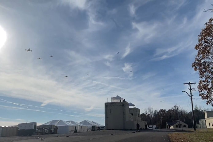
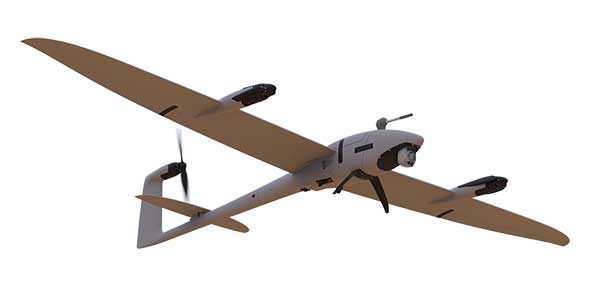
CopterPIX, an Israeli developer and manufacturer of autonomous multi-rotor UAV solutions, has unveiled its newest platform: the ERE95 Mini.
CopterPIX made the announement at UVID Dronetech 2025, which took place Nov. 26 at Expo Tel Aviv.
The ERE95 Mini is designed as an operational platform for border protection, long-range surveillance, and ISR missions. It is fully capable of GNSS-denied missions and integrates a long-range, anti-jamming communication system supporting distances of over 20 km.
According to the company, the ERE95 Mini has an endurance of 2 hours and can carry up to 5 kg of payload for up to 1 hour. It also has integrated daylight and thermal imaging for advanced surveillance. With a fully foldable frame, the platform collapses into a compact backpack-sized kit, making it suitable for rapid mobility and field operations.
Its modular “puzzle” architecture allows quick adaptation of SDR modules, optical payloads, and navigation solutions, enabling mission-specific configurations with unprecedented flexibility. To support rapid field deployment, the ERE95 Mini features a mechanical and electrical quick-connect interface, allowing operators to switch payloads in seconds and maintain continuous operational readiness across all missions.
A roundup of recent products in the GNSS and inertial positioning industry from the June 2022 issue of GPS World magazine.
SURVEYING & MAPPING
Base/Rover
For survey-grade GNSS accuracy anywhere
Photo: Bad Elf
A base/rover feature built upon the Flex GNSS receiver brings affordable centimeter-level accuracy to surveyors and geospatial professionals working anywhere in the world. The solution consists of two Flex GNSS receivers and two UHF radios, allowing customers to perform high-accuracy field data collection in areas where traditional real-time kinematic (RTK) corrections or cellular coverage is not available. Existing Flex customers can upgrade by adding Flex radio kits (pictured). The Bad Elf Flex enables data collection either as a standalone receiver or paired with apps on iOS or Android phones and tablets.
The Leica Pegasus TRK reality-capture mobile-mapping system features artificial intelligence (AI), autonomous workflows and intuitive interfaces. To comply with privacy regulations, its AI can identify and blur identifiers, such as people and vehicles, in real time. Features include advanced dynamic laser scanning and an expandable imagery system for recording, measuring and visualizing. It enables long-range mobile mapping for asset management, road construction, rail, critical infrastructure, utilities and more. The system also can create high-definition basemaps for autonomous vehicles.
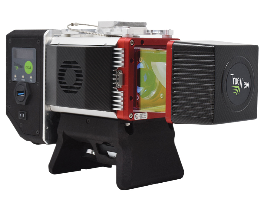
The True View 645/650 is the latest 3D Imaging System (3DIS) from GeoCue. Combined with the True View EVO data-processing software suite, it includes the full post-processing software workflow and directly integrates with Applanix POSPac. EVO supports the creation of project deliverables including ground classified point clouds, surface models, contours, digital elevation models (DEMs), volumetric analysis and wire extraction. The system delivers colorized lidar deliverables with accuracy better than 3 cm root-mean-square-error (RMSE) for the True View 645, and better than 2 cm for the True View 650.
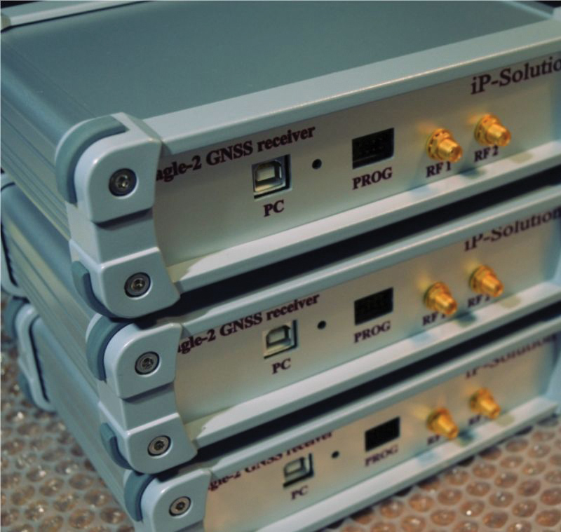
The Eagle-2 works with software-defined receivers in real time or records GNSS signals for post-processing. For post-processing, Eagle-2 supports most third-party receivers, such as MATLAB and C/C++ receivers. The front end allows a user to work with two perfectly synchronized channels connected to two antennas. The Eagle-2 supports GPS, Galileo, GLONASS , BeiDou, QZSS and SBAS.
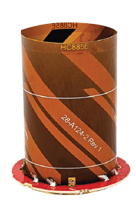
The housed HC885XF and embedded HC885EXF dual-band eXtended Filtering (XF) antennas receive GPS/QZSS L1/L5, GLONASS G1/G3, Galileo E1/ E5a/b, BeiDou B1/B2/B2a and L-band corrections services. They have been tuned to provide optimal support for the entire L1/G1/E1/B1/L-band correction and L5/G3/E5/B2 bands. The housed version, HC885XF, weighs ~42 g and is enclosed in a robust, military-grade IP67 plastic enclosure. The embedded version, HC885EXF, weighs ~8 g and is easily mounted with an embedded helical mounting ring.
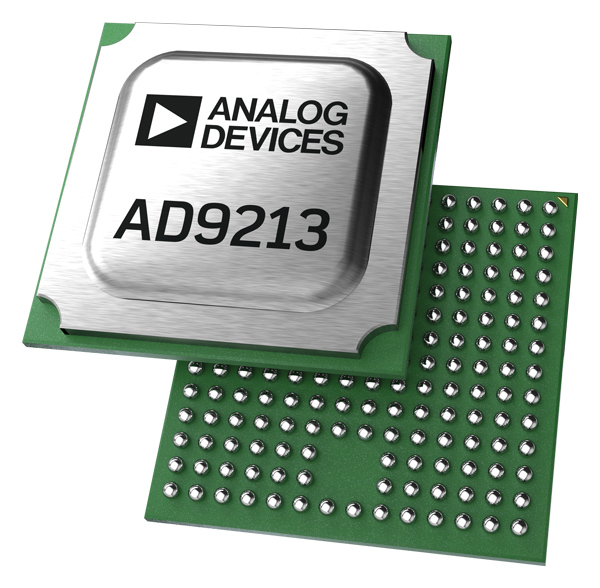
Sets performance benchmarks for harsh environments
Photo: Analog Devices
The AD9213S-CSH is a highly integrated RF analog-to-digital converter that handles 12-bit, 10.25-giga-samples per second. It is the company’s fastest ADC available for the space environment. The AD9213-CSH enables the next generation of software-defined systems for satellite communications, radar and remote sensing. The high sample rate and integrated post-processing enable further performance gains for narrow-band applications.
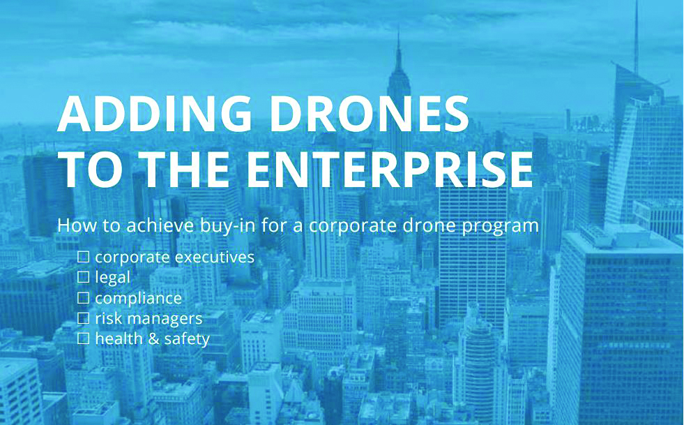
Skyward has published a free ebook, Adding Drones to the Enterprise, to provide guidance on establishing a corporate drone program. According to Skyward, the most efficient and effective drone programs are the lowest risk and most compliant. Topics covered include how to present the business value of a drone operation to corporate executives; how risk managers can optimize the workflow to ensure maximum safety; best practices for risk mitigation and regulatory compliance; tips for collaborating with legal and compliance teams on a general operating manual; and how to provide full transparency to corporate stakeholders.
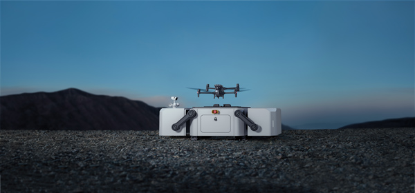
DJI’s all-in-one solution for professional drone operators includes the DJI Matrice 30 (M30) drone integrated with DJI FlightHub 2 fleet-management cloud software and DJI Dock for autonomous docking and recharging. The integrated solution is suitable for Enterprise drone users such as public safety agencies, infrastructure inspectors and energy operators. The M30 model is designed for rugged professional uses, while the fact that it fits in a backpack makes transportation and setup fast. The DJI Dock is an autonomous takeoff, landing and charging station allowing fully automatic, programmed flights with the DJI M30 Series (Dock Version). After setup, the fully charged M30 drone can take off from the dock through FlightHub 2 programmed automatic missions anywhere within a seven-kilometer radius.
The AlphaAir 1400 (AA1400) and AlphaAir 2400 (AA2400) lidar systems are lightweight, compact airborne scanners easily installed on various UAV platforms or small survey aircraft and helicopters. They are adapted to high-density point-corridor mapping applications, day or night, under leaf-on and leaf-off conditions or with dense vegetation to provide reliable results. Combined with industrial-grade GNSS receivers and high-precision inertial measurement units (IMUs), the AA1400 and AA2400 provide 2 cm to 5 cm survey-grade accuracy. They also integrate Riegl VUX lidars with waveform-lidar technology, allowing echo digitization and online waveform processing.
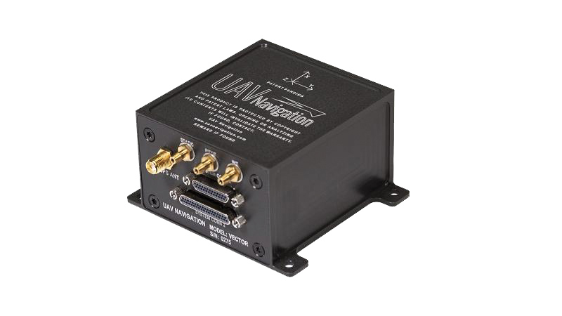
The VECTOR-600 is a robust, dependable autopilot with built-in physical and logical redundancy, allowing it to survive all individual sensor failures while maintaining accurate estimates of attitude and position. It works for fixed-wing, rotary-wing and vertical-take-off-and-landing UAVs. It provides exceptional performance in GNSS-denied environments and when there is a jamming threat. The VECTOR-600 features high quality components and an electromagnetic-resistant design tested to MIL-STD 461.
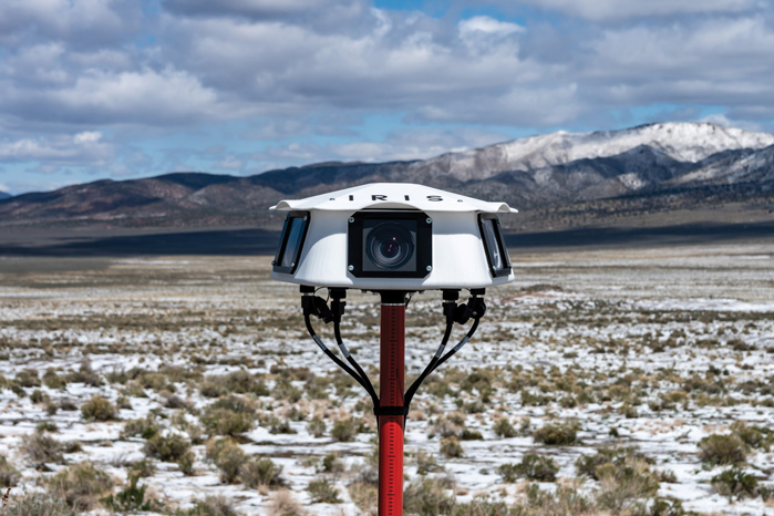
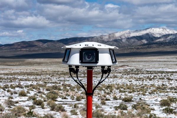
Casia G is a ground-based detect-and-avoid surveillance solution that provides 360° optical detection with alerts. It enables operators to avoid both cooperative and non-cooperative aircraft for safe beyond-visual-line-of-sight (BVLOS) flight. Casia G creates a perimeter of monitored airspace for UAVs to perform work safely, without additional payload. It is suitable for operations in fixed or temporary locations, supporting drone-in-the-box operations and augmenting or replacing human visual observers. Casia G sees the entire sky, with uniform probability and resolution, 10 times per second, covering a majority of small UAS use cases.
Iris Automation has announced the commercial availability of Casia G, a ground-based version of its detect-and-avoid surveillance solution.
Using the same patented artificial intelligence (AI) and computer-vision technology as Iris Automation’s onboard solutions, Casia G provides 360° optical detection with alerts. It enables operators to avoid both cooperative and non-cooperative aircraft for safe beyond-visual-line-of-sight (BVLOS) flight.
Casia G creates a perimeter of monitored airspace for UAVs to perform work safely, without additional payload. It’s suitable for operations in fixed or temporary locations, supporting drone-in-the-box operations and augmenting or replacing human visual observers. BVLOS flight for unmanned systems has been challenging due to right of way concerns, specifically the inability for unmanned aircraft to successfully see and avoid other aircraft.
“A human has sufficient visual acuity to see airborne traffic only within a +/-5 degree field of view around our focal point. We have to scan the sky, and are frankly not very good at it,” said Jon Damush, CEO, Iris Automation. “Casia G sees the entire sky, with uniform probability and resolution, 10 times per second — without distractions or breaks. This solution for airspace awareness covers a large majority of small UAS use cases, but at a price point that is economically viable and without complex integration.”
Casia G can be expanded by adding additional units in a mesh to create a network of detection nodes for large-area air risk mitigation. The system then provides a single feed of cooperative and non-cooperative air traffic, available to an operator’s traffic management system. This provides a path to approvals for both larger area and one-to-many operations by enabling a holistic view of the airspace, the company said.
Casia G has already obtained a BVLOS waiver on behalf of the City of Reno. Iris Automation is in the process of proving additional deployment patterns and concepts of operation with the FAA.
UAVOS has successfully completed the S1-V300 medium-altitude long-endurance (MALE) unmanned aerial system (UAS) prototype designed to check basic aircraft systems.
The advanced UAS model is based on the Saker MALE UAS design that achieved operational capability in 2020. The S1-V300 MALE UAS prototype is an upgrade to the unmanned system and features a new design and a more powerful heavy fuel engine with 260 HP offering greater speed, payload, and endurance of 28 hours with a range of 4,020 km.
Work performed under UAVOS’ MALE UAS program using its proven Saker aircraft capabilities has enabled it to create a new-generation S1-V300 MALE unmanned platform. The aircraft features unique UAVOS avionics solutions and a redundant flight control system that will enable complex missions.
The S1-V300 UAS will be able to support a variety of overland and maritime intelligence, surveillance and reconnaissance (ISR) missions. The improved S1-V300 prototype is equipped with both line-of-sight (LOS) and beyond-visual-line-of-sight (BVLOS) datalink systems for over-the-horizon operations. Additionally, the aircraft can be integrated with multiple ISR sensors, including electro-optical infrared (EO/IR) cameras and a synthetic aperture radar (SAR) that offers all-weather, day/night performance for a wide-area search capability.
The S1-V300 MALE UAS next-generation capabilities combined with medium-altitude persistence make it a suitable platform to add with long-range radar, signals intelligence (SIGINT) payloads, communication-relay payloads, and counter electronic-warfare systems. Additional retrofits include stronger wings and extra hard points for carrying an external payload of 300 kg.
The S1-V300 has fully autonomous operation capability. It is equipped with automatic taxi-takeoff and landing systems, satellite communication for extended range, and fully redundant avionics. It is designed to operate in harsh environments and is adapted to perform in extremely hostile, dry and dusty ambient air. The aircraft features a 8.7-meters-long fuselage and a 18.7 meters wingspan, is capable of flying at 220 km/h, and has an endurance of more than 28 hours.
The Autel Robotics Dragonfish Lite and Pro UAVs are now available in the United States, joining the Dragonfish Standard and providing more options and choices for UAV pilots.
The rugged Dragonfish UAVs are capable of vertical takeoff and landing (VTOL) with both multi-rotor and winged flight, with an endurance of up to 180 minutes. They are suitable for professional applications such as energy, mining, defense and surveillance. Maximum winged flight speed is 30 m/s (108 km/h, 67 mph), and maximum video transmission range is 30 km (18.6 miles) with a base station.
The 1-tap take-off and landing capability point-and-click user interface, and other smart autonomous features make the Dragonish simple for anyone to operate, according to maker Autel Robotics. The aircraft can make a smart decision to either land or return to base in case of issues such as loss of GPS signal, loss of operator communications, or low battery power.
The Dragonfish tilt-rotor system will automatically transition to multi-rotor mode if adverse conditions cause fixed-winged flight to stall or become unsustainable. The Dragonfish battery, barometer, positioning system, compass and inertial measurement unit all have backup modules to ensure flight safety.
Dragonfish UAVs can carry a variety of payloads, including standard high-resolution cameras, 50x optical zoom cameras, 12-megapixel wide-angle cameras, 1280 x 1024 high-resolution infrared cameras, and laser rangefinders for various imaging, surveillance and mapping tasks.
All Dragonfish UAVs are built from tough carbon-fiber and fiber-glass composite, providing excellent IP43 wind and weather resistance. Despite the strong construction, these aircraft are designed to be easily disassembled for space-saving transport. They can be assembled in three minutes without tools. Disassembled, Dragonfish fits in the back of any car or SUV.
The larger Dragonfish Pro provides the longest flight time of the series, 180 minutes with payload, and has a 6,000-m (19,685-ft) flight ceiling, making it suitable for applications such as discreet long-endurance surveillance and wide-area mapping. The maximum payload capacity is 2.5 kg.
Compact and lightweight at 4.5 kg (including two batteries) with a 1,600-mm wingspan, the Dragonfish Lite can carry a 1-kg payload up to its service ceiling of 4,000 m, and has 75 minutes’ flight endurance.
Dragonfish Standard is already available. Dragonfish Lite and Dragonfish Pro will be available in the U.S. starting in April.
Firmware Release
The company also announced that pilots of Autel Robotics’ EVO Nano and EVO Lite series drones can download a firmware update that adds features including Dynamic Track 2.1 (person only), SuperDownload, 8-bit Log video, HDR video and other improvements. Some of these new firmware features are available now for selected models, and other features will become available for the EVO Lite, Lite+, Nano and Nano+ series in the near future.
Taoglas announced its smallest 9-in-1 combination antenna with dual-band GNSS and high-performance 5G/4G, the Taoglas MA990 Guardian.
Taoglas made the announcement at Mobile World Congress (MWC) Barcelona 2022, which takes place Feb. 28–March 3; Taoglas is exhibiting at booth #5E32.
The Taoglas MA990 Guardian antenna is a small 9-in-1 combination antenna with dual-band GNSS (L1/L2) and globally supported cellular (5G/4G). It has been designed to support emerging market demand for modules that cover specific 5G/4G bands.
For example, two of its eight cellular MIMO antennas cover from 600 to 6,000 MHz, while another two are optimized for 3,000 to 6,000 MHz to cover high-band 5G and C-band/CBRS applications. The product is designed to operate on all carrier networks globally and is future-proofed to work with latest 5G routers in the market.
Housed in a low-profile, robust, IP67-rated waterproof, adhesive-mount external enclosure, the MA990 is designed for space-constrained, mission-critical applications, including asset and vehicle tracking, first- responder vehicles and high-definition video sources such as surveillance cameras.
The Taoglas MA990 also is highly customizable, including for any variation of antennas below 9-in-1 and the addition of Wi-Fi/single-band GNSS.
Raytheon BBN-led team recently supported DARPA’s fifth OFFSET program field exercise. (Photo: Raytheon)
Raytheon Intelligence & Space, a Raytheon Technologies business, recently supported the fifth OFFensive Swarm-Enabled Tactics (OFFSET) DARPA program field exercise.
Using integrated swarm technology developed by a Raytheon BBN-led team, a single operator successfully controlled a swarm — composed of 130 physical drone platforms and 30 simulated drone platforms — both indoors and outdoors in an urban setting. Raytheon BBN provides advanced technology research and development with a focus on national security priorities.
During the exercise, the team used a combination of commercial off-the-shelf and custom-built hardware and software to deliver swarm autonomy. This enabled a single or small group of operators to direct and manage the activities of a large swarm of autonomous air and ground vehicles with minimal training.
“Controlling a drone swarm changes the way an operator or group of operators think about the drones,” said Shane Clark, Raytheon BBN OFFSET principal investigator. “Takeaways from this exercise help inform us of the inflection points between utility and manageability.”
Inexpensive Hardware
A key element of the program is the use of inexpensive hardware. Without the powerful computing and sensing capabilities available in larger more expensive platforms, Raytheon BBN needed to create a broad library of simple tactic building blocks used to create plans to accomplish mission objectives.
Raytheon BBN also designed and configured a scalable, modular and decentralized approach to manage a variety of current and future platforms and missions. Whenever possible, the drones collaborate actively to decide how to accomplish a specific mission most efficiently.
“Our software is smart enough to assign drones with the right capabilities to the appropriate set of tasks,” Clark said. “For example, if the task is to surveil a building, multiple drones will be dispatched, with each surveilling portions of the building. The software considers each platform’s sensor capabilities, and tasks drones with downward-facing cameras to surveil the roof.”
Once the drones are deployed, their collaboration allows them to understand what parts of a building have been explored and where the gaps are. They then autonomously select how to fill in those gaps.
Virtual Reality Interface
To tackle the complexities of human swarm interfaces, the Raytheon BBN team created a virtual reality interface in addition to traditional camera views. It takes feeds from all the swarm assets to create an interactive virtual view of the environment.
“You can look behind the building to access a view of drone locations, for example, and use the virtual reality environment to test and see if your mission is viable,” Clark said. “We also developed a speech interface with the operationally deployed Tactical Assault Kit, or TAK, integration capability that enables the operator to act quickly while maintaining situational awareness over many systems simultaneously.”
The Raytheon BBN-led team includes Smart Information Flow Technologies, or SIFT, and Oregon State University. The team is contracted by DARPA to demonstrate its swarm capabilities during Army Expeditionary Warrior Experiment 2022 taking place in February to March, and hosted by the Army Maneuver Battle Lab.
FLIR Systems Inc. has acquired Altavian Inc., a privately held manufacturer of small unmanned aerial systems (sUAS) for defense and public-safety customers.
Altavian’s airframes integrate multiple sensors, including FLIR thermal technology, to provide users with decision support and intelligence, surveillance and reconnaissance (ISR) capability.
Based in Gainesville, Florida and founded in 2011, Altavian designs and manufacturers Group 1 UAS solutions for long or short range operations. With both quadcopter and fixed-wing UAS designs, Altavian’s expertise includes aeronautics, avionics, and software, and its solutions are engineered around an open system architecture aligned to the needs of government and defense customers.
Altavian is one of five drone manufacturers approved by the U.S. Department of Defense under the Blue sUAS program to sell to the U.S. military and federal agencies.
“Altavian’s proven engineering expertise and assets will allow us to offer customers the most comprehensive solution portfolio of any American sUAS provider,” said Roger Wells, general manager of the Unmanned Systems and Integrated Solutions business of FLIR Systems’ Defense Technologies Segment, under which Altavian will be integrated. “With the addition of both a low-cost, rapidly deployable quadcopter and a longer range fixed-wing UAS, FLIR is strengthening its already impressive drone lineup, including our Black Hornet and SkyRaider platforms used extensively by militaries around the globe. We’re excited about the multiple new franchise opportunities FLIR will be able to pursue for defense, public safety, and industrial markets worldwide.”
For more information about FLIR Systems’ existing sUAS solutions, visit flir.com/defense-uas.
On Feb. 3, drone company Quaternium broke its own record for long flight time with a hybrid-fuel electric drone.
The Quaternium HYBRiX UAV took off at 08:52 a.m. in Valencia, Spain, and landed at 17:02 p.m., performing a stationary flight of 490 minutes.
The new endurance record of 8 hours and 10 minutes of non-stop flight time was accomplished with an experimental version of the company’s HYBRiX 2.1 drone, which carries 25 kilograms of maximum take-off weight.
Six years ago, the startup Quaternium developed its first hybrid fuel drone, inspired by hybrid cars from the automotive industry.
In 2015 the company flew its hybrid drone, the multirotor HYBRiX, for 3 hours and 10 minutes. According to the company, Hybrid multirotors multiply flight time more than 10 times compared to electric solutions.
The company has published a flight video with the demonstration of the record.
Most multicopter drones provide flight times of 25 to 40 minutes, with the pilot needing to carry multiple batteries into the field.
The HYBRiX project is supported by the European Union through its Horizon 2020 innovation program, which fosters disruptive projects in innovation, excellent science and industrial leadership. The project has received awards from institutions such as AUVSI, CDTI and the Spanish government.
The Quaternium team was motivated to develop a long-endurance drone because it will help first responders and and firefighters to identify hot spots and search for survivors in the event of a catastrophe, the company said in a press release.
Two new small unmanned aerial systems (sUAS) are available to the U.S. government defense and security markets.
Auterion Government Solutions Inc. and Quantum-Systems GmbH have partnered to bring the Vector and Scorpion to market. The partnership brings together high-quality sUAS hardware with a secure, scalable, open source, operating system, Auterion OS.
Auterion OS is employed on sUAS from small multi-rotors to hybrid VTOL Group 2 air vehicles. The open-source operating system aligns with the Defense Department’s Group 1 UAS Architecture.
2-in-1 UAS
Vector and Scorpion form a 2-in-1 system kit. Scorpion is a tri-copter that can be used for dynamic urban environments and other mission sets that require a combination of maneuverability and hover to collect intelligence, surveillance and reconnaissance (ISR) data, as well as situation awareness information. If required, it comes with a tethering system to enable 24/7 operations.
By configuring the base fuselage with fixed wings and tail section, Scorpion transforms into Vector, an energy-efficient, fixed-wing VTOL for longer range, longer endurance ISR missions.
The Vector. (Photo: Quantum-Systems)
Command and control
Quantum-Systems uses a proprietary flight control stack as well as its qBase command and control software on the two air vehicles.
When the platforms are integrated with Auterion Enterprise PX4 software, Auterion Ground Station software, and the Auterion Hand-Held Ground Control Station (H-GCS) they form an open ecosystem that is aligned and integrated with DoD’s Group 1 UAS Architecture and requirements for a common Group 1 control system.
The integration enables these sUAS to be extensible, tailorable and interoperable for customers in both the U.S. defense and security markets.
“We are excited to be working with Quantum-Systems to bring forth a new, integrated, rucksack portable sUAS that we feel will transform the way our customers collect, process and disseminate ISR and Situation Awareness information, in all environments,” said David Sharpin, CEO of AGS.
“By setting up a U.S. entity, Quantum-Systems will move closer to the customer while working on setting up a large-scale U.S. production,” said Florian Seibel, CEO of Quantum-Systems.
CP Aeronautics offers American-built combat-proven unmanned aerial systems for defense, homeland security and civil applications
CP Technologies has launched a new division, CP Aeronautics, to provide integrated turn-key solutions based on unmanned aerial systems (UAS) platforms, payloads, data links, ground control stations (GCS) and communications for defense and civil applications.
Designed as leading-edge UAS-based solutions, CP Aeronautics’ systems offer operationally proven solutions for intelligence, surveillance and reconnaissance (ISR) systems requirements. CP Aeronautics’ broad product portfolio has demonstrated excellent performance and operability in demanding environments, the company stated in a press release. Backed by continuous research and development, these systems are built on three decades of technological and operational experience.
“Through our in-house capability as a UAS manufacturer and integrator with specialist subsidiaries and technology partners, we offer a complete range of subsystems including air vehicles, inertial navigation and avionics, electro-optical payloads (EO), communications, propulsion systems, launch and retrieval systems, command and control units,” said Brad Pilsl, vice president of business development at CP Aeronautics. “We also offer high-end training solutions for our partners and customers.”
CP Aeronautics will support government and commercial customers with the entire infrastructure necessary for development, production, integration, flight-testing, certification and operational support of UAS throughout their service.
The combat-proven operational systems include:
Orbiter 2 Small-UAS (SUAS)
Orbiter 3 Small Tactical UAS (STUAS)
Orbiter 4 Small Tactical UAS (STUAS)
Aerostar Tactical UAS (TUAS)
Dominator XP (MALE UAS)
Pegasus 120 high-performance multi-mission vertical takeoff and landing (VTOL) UAS
The Canadian Department of National Defence has awarded a $11.44 million contract to Space Flight Laboratory (SFL) at the University of Toronto Institute for Aerospace Studies (UTIAS) for the development of multipurpose microsatellites to support Arctic surveillance.
Upon successful completion and testing of the prototype, two additional microsatellites will be built to create a small formation.
The UTIAS SFL microsatellites, which are now being developed, will include multiple sensors on a constellation of microsatellites operating in close formation in low Earth orbit to allow for quick and timely detection and identification of surface or airborne targets.
The concurrently obtained sensor observations are expected to improve the reliability of the detection and identification performance, which is not feasible when individual sensors are located on non-collaborating satellites.
On behalf of Defence Minister Harjit S. Sajjan, member of Parliament for York Centre, Michael Levitt announced the contract on Feb 1 during a ceremony at U
“Space Flight Laboratory is honored to assist the Department of National Defence in developing next-generation satellite technology that could be used to monitor Canada’s vital Arctic region,” said SFL Director and Founder Robert E. Zee. “We are pleased that this investment acknowledges SFL as one of the world’s preeminent developers of advanced attitude control and formation-flying technologies for microsatellites.”
Established in 1998 as a self-sustaining specialty lab at the University of Toronto Institute for Aerospace Studies (UTIAS), SFL has built more than 25 nano- and microsatellites with over 95 cumulative years of successful operation in orbit. SFL’s attitude-control technologies have also been applied successfully in several other microspace programs as well, including the 2016 GHGSat-D greenhouse gas emissions monitoring satellite and the 2013-2014 BRITE space astronomy constellation.
As outlined in its defence policy Strong, Secure, Engaged, the Department of National Defence is investing in defence research and development to produce innovative solutions to surveillance challenges in Canada’s North, particularly in the priority areas of Arctic joint intelligence, surveillance and reconnaissance.
Surveillance solutions support the Canadian government’s ability to exercise sovereignty in the North and provide a greater awareness of safety and security issues, as well as transportation and commercial activity in Canada’s Arctic. In addition, solutions achieved under the ADSA program will contribute to joint efforts between Canada and the United States to modernize elements of the North American Aerospace Defense Command (NORAD).
The ADSA S&T Program leverages innovative science & technology expertise from other government departments, academia, industry and allies, to identify, assess and validate technologies in support of air and maritime surveillance, particularly in the North. Through a five-year investment of $133M through to 2020, the ADSA S&T Program is supporting the development of options for enhanced domain awareness of air, maritime surface and sub-surface approaches to Canada, in particular those in the Arctic.