TDK Corporation has announced Trusted Positioning STRIDE, an embedded pedestrian dead-reckoning (PDR) software solution engineered specifically for wearables — smart watches, head-mounted devices, glasses and compact sensors. STRIDE provides reliable positioning without the power and hardware demands traditionally required for GNSS-based tracking.
STRIDE’s low-power, sensor-agnostic software engine fuses inertial data with GNSS and opportunistic wireless signals, delivering continuous location tracking both indoors and outdoors.
STRIDE runs as embedded software, giving OEMs freedom to deploy positioning without redesigning hardware or relying on cloud connectivity, according to the company. STRIDE processes sensor data in real time, ensures low latency, and can be configured for on-device, companion-device, or cloud-assisted architectures. This flexibility helps manufacturers balance performance, power and form-factor constraints based on their device strategies.
Main features and benefits
Low-power on-device mode: Enables continuous PDR in platforms constrained by power, memory or thermal limits.
Geofencing mode: Allows location-based alerts and boundaries for children’s wearables, personnel safety, or activity zones.
Tethering of sensors: Seamlessly uses GNSS and sensors from a companion phone, reducing hardware demand on the wearable.
Off-device processing: Supports computation on a smartphone or in the cloud for advanced analytics or battery saving.
GNSS duty-cycling: Dramatically extends battery life by activating GNSS only when necessary.
Flexible mounting support: Works across watches, smart glasses, helmets, chest-mounted devices and more.
Embedded and real-time: Runs directly on the device with low latency — no dedicated infrastructure, no specialized hardware
Hardware-independent and sensor-agnostic: Integrates easily with a broad range of IMUs and GNSS receivers.
STRIDE is available immediately for trial evaluation, OEM integration, or companion-device implementations.
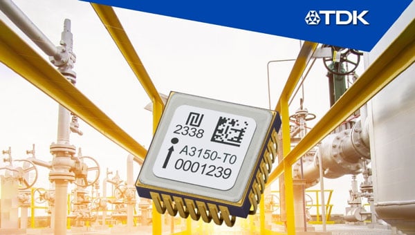
TDK Corporation has introduced the Tronics AXO315T0, a high-temperature MEMS accelerometer designed for measurement while drilling (MWD) applications in the energy sector. The new sensor features a ±14 g input range and a digital interface, expanding TDK’s MEMS inertial sensor portfolio.
The AXO315T0 uses TDK’s closed-loop architecture, which delivers advanced vibration rectification and resistance to operational shocks. The device maintains a bias residual error of 0.8 mg across its operating temperature range of minus 30°C to 150°C, enabling precise and continuous inclination measurements for directional drilling tools exposed to high temperatures.
To meet the demanding reliability requirements of complex drilling operations in harsh environments, TDK qualified the AXO315T0 through more than 1,000 hours of powered life testing at 165 degrees Celsius, temperature cycling from minus 55 degrees Celsius to 165 degrees Celsius, and high-temperature vibration tests at 20 g RMS random vibration combined with a 50 g sine sweep.
The AXO315T0 offers a typical bias drift of less than 1 mg without recalibration after 1,000 hours at high temperature, providing a digital, low size, weight and power (SWaP) alternative to traditional quartz accelerometers. This advancement supports a new generation of MWD tools capable of long-term operation at elevated temperatures without compromising performance.
AXO315T0 sensors and evaluation boards are available for sampling and customer evaluation. TDK plans to further expand its MEMS portfolio for the energy market with a new accelerometer capable of operating at temperatures up to 175 °C.
Main applications:
Measurement while drilling (MWD)
Logging while drilling (LWD)
Directional drilling
Wireline
Key features and benefits:
±14 g input range, single-axis accelerometer
Operating temperature range: minus 30 °C to 150 °C
A roundup of recent products in the GNSS and inertial positioning industry from the February 2023 issue of GPS World magazine.
SURVEYING & MAPPING
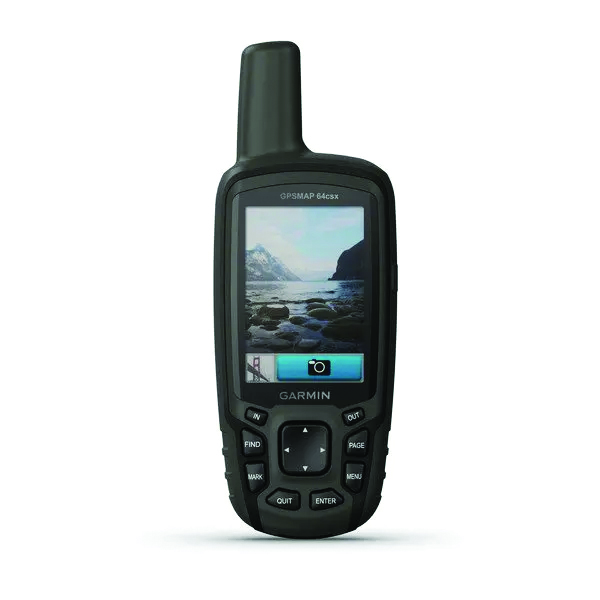
GPSMAP 64csx handheld GPS receiver (Image: Gamin)
Handheld GPS With navigation sensors and camera
The GPSMAP 64csx handheld GPS receiver comes with multi-GNSS support, TopoActive mapping, barometric altimeter, three-axis compass, and wireless connectivity via Bluetooth and ANT+ technology. It also has an 8 MP autofocus camera. The GPSMAP 64csx is built to withstand rugged terrain and is water-resistant. The highly sensitive receiver and quad helix antenna provide support from GPS, GLONASS and Galileo. Preloaded TopoActive maps include waterways, natural features, buildings and international boundaries. It is compatible with smartphones so users can receive email and text messages and share location data with others. Garmin, garmin.com
The Venus Laser RTK receiver comes with an inertial measurement unit. It can be used in its traditional mode with a range pole, or in laser mode without a pole, enabling GNSS surveying beyond typical limitations. In traditional mode, it has tilt compensation of up to 60° with an accuracy of 2.5 cm; in laser mode, it has the same tilt compensation but an accuracy of 5.5 cm. The receiver is powered by a SinoGNSS K8 high-precision module capable of up to 1,590 channels. It can survey using GPS, BDS-2, BDS-3, GLONASS, Galileo, QZSS and SBAS constellations. Other features include Bluetooth connectivity, more than 20 hours of battery life, and ruggedness (it is dust and waterproof and is designed to survive a two-meter drop). ComNav Technology Ltd., comnavtech.com
Leica iCON gps 160 (Image: Leica Geosystems)
Smart Antenna With features to increase productivity on the construction site
The Leica iCON gps 160 is a next-generation construction smart antenna designed to increase productivity in stakeout and measurement applications on the jobsite. It features a large color display with clear navigation for quick and easy setup without additional hardware. It is optionally available with an inertial measurement unit (IMU) for tilt-compensation functionality up to 20°. It seamlessly integrates with all Leica iCON construction instruments and controllers as well as the iCON field software for precise, real-time verification. Leica Geosystems, leica-geosystems.com
The Xsens Vision Navigator (Image: Movella)
GNSS inertial navigation Integrates position inputs from three high-accuracy sources
The Xsens Vision Navigator integrates position inputs from three high-accuracy sources including dual-antenna real-time kinematic (RTK) GNSS receivers; an inertial measurement unit (IMU) incorporating a three-axis accelerometer, a gyroscope and magnetometer; and a visual inertial odometry system. It can optionally accept input from an external wheel-speed sensor. The positioning sensor achieves centimeter-level accuracy when operating in GNSS mode with an RTK fix. When GNSS signals are not available, the product alone achieves accuracy of 2% of travel distance, or 0.75% when supplemented by wheel speed. Xsens Vision Navigator is suitable for outdoor positioning applications such as material handling equipment, commercial and specialist vehicles, last-mile delivery, inspection equipment and UAVs, agricultural equipment, mining equipment and utility robots. Movella, movella.com
SILC Eyeonic Vision System (Image: SiLC)
Coherent Vision Solution Delivers high levels of vision perception
The Eyeonic Vision System is a frequency-modulated continuous wave lidar solution, which delivers high levels of vision perception to identify and avoid objects with low latency. At the core of the Eyeonic Vision System is a fully integrated silicon photonics chip. It provides more definition and precision than legacy lidar solutions, with roughly 10 milli-degree of angular resolution coupled with millimeter-level precision. These features enable this solution to measure the shape and distance of objects with high-precision and at a large distance. The system combines the Eyeonic Vision Sensor and a digital processing solution based on a powerful field-programmable gate array. The flexible architecture enables synchronization of multiple vision sensors for unlimited points per second.
SiLC, silc.com
OEM
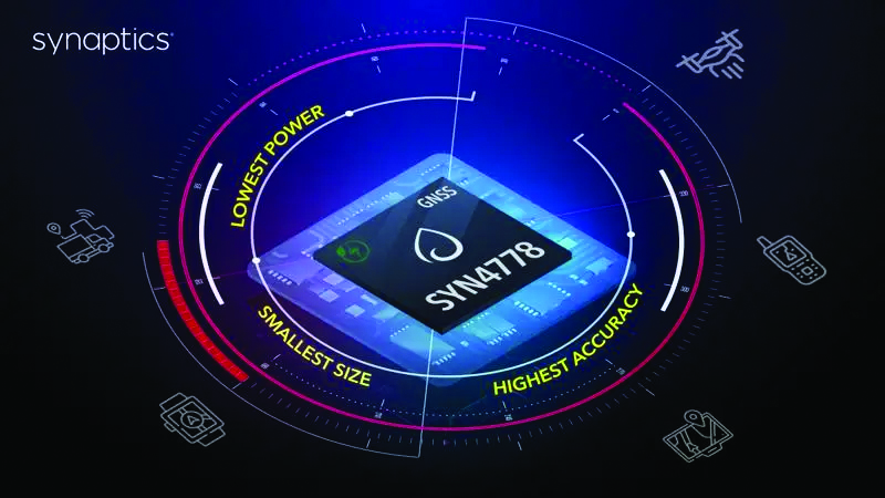
The SYN4778 (Image: Synaptics)
Integrated Circuit Designed for the internet of things
The SYN4778 is a small, low-power GNSS integrated circuit designed to extend battery life, reduce product size, and enhance performance of advanced location-based services for internet of things (IoT) devices — wearables, mobile accessories, asset trackers, UAVS and transportation devices. It includes advanced multipath interference mitigation using L5-band signals from GPS, Galileo, BeiDou, NAVIC, SBAS and QZSS. The chip also uses the L1 satellite band to reduce both the time to first fix, and the power consumed, improving the end-user experience and enabling product developers to add additional functionality and features to their IoT devices. Synaptics, synpatics.com
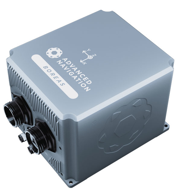
The Boreas D70 is a fiber-optic gyroscope (FOG) inertial navigation system (INS), part of the Boreas digital FOG series. The technology is suited to surveying, mapping and navigation across subsea, marine, land and air applications. It also could be adopted for vehicular applications, including autonomous vehicles and aircraft where weight and size are at a premium. The Boreas D70 combines closed-loop DFOG and accelerometer technologies with a dual-antenna real-time kinematic (RTK) GNSS receiver. These are coupled with an artificial-intelligence-based fusion algorithm to deliver accurate and precise navigation. Advanced Navigation, advancednavigation.com
The u-blox NEO-F10T (Image: u-blox)
Timing Module Dual-band and secure for 5G communications
The u-blox NEO-F10T offers nanosecond-level timing accuracy, meeting the stringent timing requirements for 5G communications. It is compliant with the u-blox NEO form factor (12.2 mm x 16 mm), allowing space-constrained designs to be realized without the need to compromise on size. The NEO-F10T is the successor to the NEO-M8T module, providing an easy upgrade path to dual-band timing technology. This allows NEO-M8T users to access nanosecond-level timing accuracy and enhanced security. u-blox’s dual-band technology mitigates ionospheric errors and greatly reduces timing error, without the need for an external GNSS correction service. u-blox, u-blox.com
TRANSPORTATION
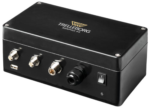
SafePilot P3 (Image: Trelleborg)
Maritime Systems Provides data on vessel positioning
The SafePilot P3 navigation system provides real-time data on vessel positioning and movement in tight waterways. It uses motion sensors and two GNSS antennas to measure the position and heading of vessels in three dimensions, minimizing time and difficulty associated with piloting procedures. SafePilot P3 has a backup battery to maintain functionality in the event of a power outage. This navigation system improves situational awareness while navigating waterways and ports globally, and also enhances communication between the captain, pilot, tug operators and canal personnel while vessels are transiting a canal and approaching a port.
Trelleborg, trelleborg.com
FusionEngine software (Image: Point One Navigation)
Positioning Engine Assures functional safety of ASIL-B
FusionEngine software, which is rated for automotive safety integrity level (ASIL), is now compatible with STMicroelectronics’ Teseo ASIL Precise Positioning GNSS chipset TeseoAPP. This assures functional safety of ASIL-B, a requirement for Level 3+ advanced driver assistance systems (ADAS). It can be integrated into several different host processors to enable high-level ADAS and autonomous driving systems. The combination of TeseoAPP’s receiver and the STA5365S external RF front-end provides dual-band measurement data for all visible GNSS satellites to the main host processor into which
FusionEngine is integrated. Point One Navigation, pointonenav.com
Ghost Autonomy Engine (Image: Ghost)
Autonomous driving software for level 4 driver assistance
The Ghost Autonomy Engine achieves the reliability required to bridge the gap between driver assistance capabilities L2 or L2+, and self-driving that does not rely on a human backup (L4). The software provides a stereo-vision neural network that delivers per-pixel depth in real time. It is capable of detecting and segmenting key features in a scene without needing to classify or recognize them. The physics-based perception system can handle the long tail of obstacles on the road, even those never seen before. Ghost, ghostautonomy.com
Vista-X120 Plus (Image: Cepton)
Lidar Provides 3D perception
The Vista-X120 Plus is a slim automotive lidar device for real-time adaptive 3D perception for advanced driver assistance. Its software-definable region of interest enables higher dynamic perception capabilities, while an adjustable central field of view with increased angular resolution improves accuracy in detection and classification of objects when driving. The region of interest is also configurable in real time in both horizontal and vertical directions. The Vista-X120 Plus is compact at 140 mm x 30 mm, improving OEM integration and placement options without disrupting vehicle appearance. Cepton, cepton.com
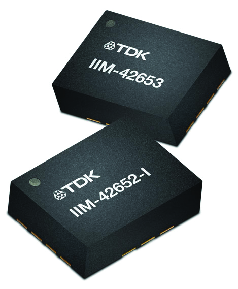
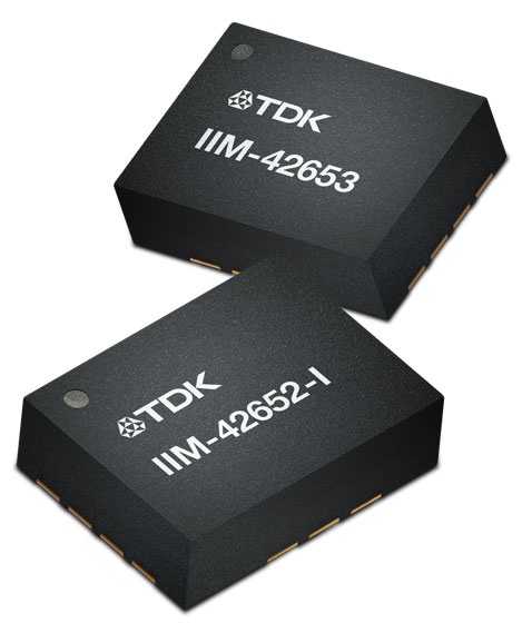
IIM-42653 and IIM-42652-I sensor platforms (Image: TDK Corporation)
Sensor Platforms Targets industrial and navigation applications
The IIM-42653 and IIM-42652-I sensor platforms consist of 6-axis IMUs, which target industrial and navigation applications requiring high force sensitive resistor (FSR) performance or inertial navigation software. The IIM-42653 platform — a robust, low-noise, low-power, 6-axis IMU — is capable of a gyro-programmable output of 4,000 dps and an accelerometer-programmable output of 32 g. These features make the IIM-42653 suitable for industrial-grade or high-end automated guided vehicles, automated mobile robots and unmanned aerial vehicles. The IIM-42652-I platform offers hardware authentication and can be integrated with TRACK dead-reckoning software from Trusted Positioning. TRACK filters GNSS multipath errors and provides a continuous navigation solution when GNSS signals are unavailable. TDK Corporation, invensense.tdk.com
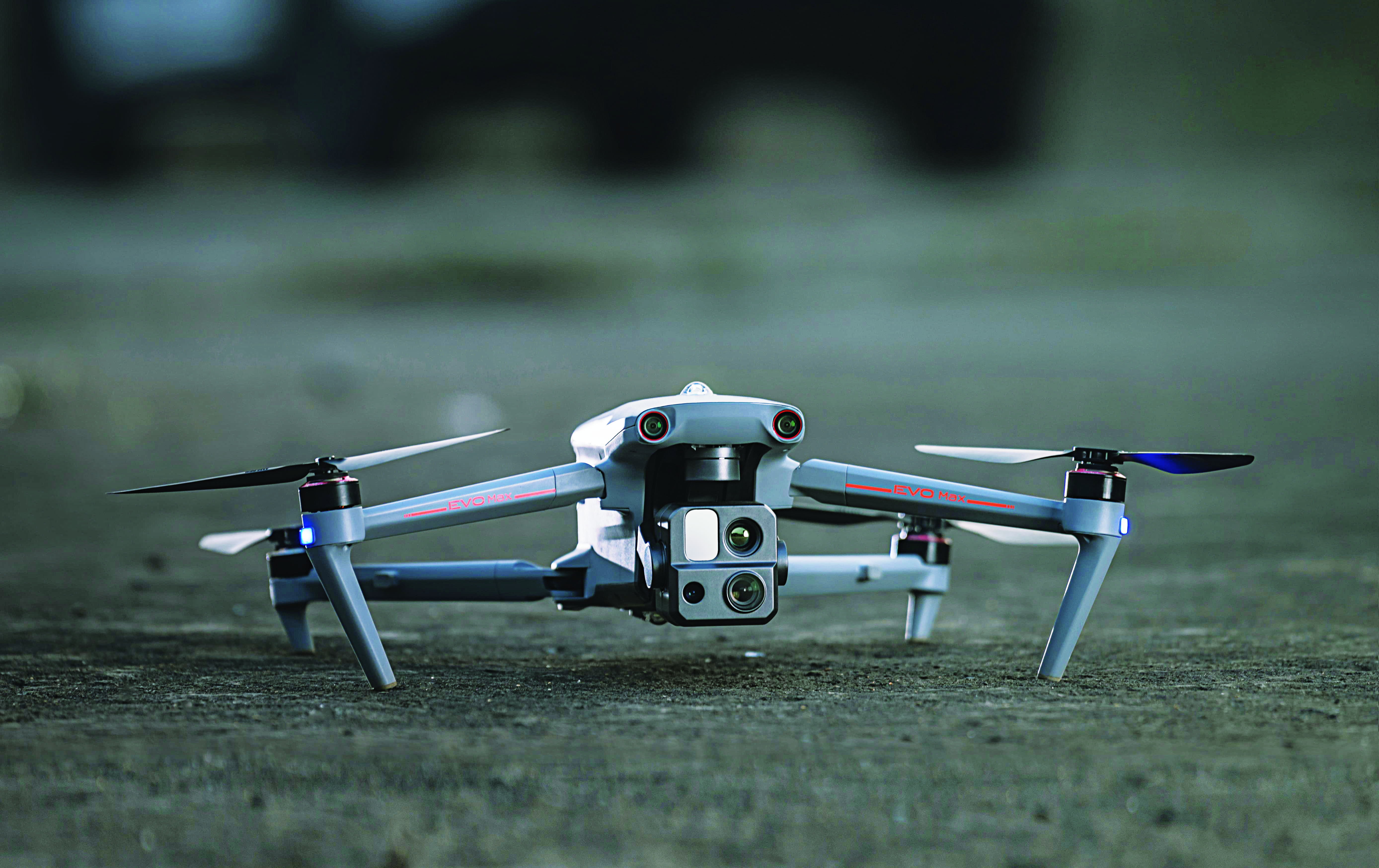
VO Max 4T (Image: Autel Robotics)
Flight Platform
For enterprise and professional applications
The EVO Max 4T autonomous flight platform provides omnidirectional obstacle avoidance and tri-anti-interference capability to ensure flight safety and stability in high-interference environments. It is equipped with three high-quality cameras including a 48 MP telephoto camera, a 50 MP wide-angle camera and an infrared camera. The platform has a range of navigation and data-acquisition functions, including 3D flight routes, PinPoint Mode, Team Work, Polygon Mission, Waypoint Mission and Oblique Photography. EVO NEST is a base for automatic take-off, landing, charging and mission planning for EVO series UAVs. It is designed for all-weather operation and can be easily transported. Autel Robotics, autelrobotics.com
On Jan. 4, TDK Corporation announced the addition of the IIM-42653 and IIM-42652-I platforms to its InvenSense SmartIndustrial family of compact and low-power sensor platforms. IIM-42653 and IIM-42652-I consist of 6-axis IMUs, which target industrial and navigation applications requiring high force sensitive resistor (FSR) performance or inertial navigation software.
The IIM-42653 platform—a robust, low-noise, low-power, 6-axis IMU—is capable of a gyro-programmable output of 4,000 dps and an accelerometer-programmable output of 32 g. These features make IIM-42653 ideal for applications including industrial-grade or high-end automated guided vehicles, automated mobile robots and unmanned aerial vehicles.
The IIM-42652-I platform, a compact 6-axis IMU, offers hardware authentication and can be integrated with TRACK dead reckoning software from Trusted Positioning, a TDK Group company. The TRACK software, which is available for purchase through a licensing agreement, filters GNSS multi-path errors and provides a continuous navigation solution when GNSS signals are unavailable.
IIM-42653 is available now for select partners and customers only and will be available at TDK distribution partners in April. IIM-42652-I is available now at InvenSense-authorized distributors.
TDK Corp. has announced that Trusted Positioning Inc. (TPI), a TDK Group Company focused on creating and selling positioning software, has joined the New Business Promotion Center of TDK Corporation as an independent business unit.
With the expanding positioning and location tracking market, this move signals TDK’s commitment to developing TPI as an independent software solutions business, according to a TDK press release.
TPI has been developing integrated positioning solutions for decades, with software deployments in more than 50 million systems worldwide. The company’s innovation team is comprised of experts in inertial navigation, dynamic motion mechanics, geomagnetic positioning, GNSS, Bluetooth low energy, Wi-Fi and other wireless positioning techniques.
TPI’s inertial navigation solutions provide highly accurate positioning for the autonomous vehicle, automotive infotainment/telematics, robotics, two wheeled micro-mobility and indoor positioning markets.
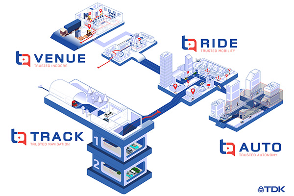
VENUE (previously Coursa Venue) is TPI’s flagship indoor positioning solution based on inertial, geomagnetic and other wireless technology. The indoor positioning market is exploding with the now-ubiquitous GPS everywhere, except indoors. TPI’s indoor positioning requires minimal infrastructure investment, which reduces costs, and is well suited to scale for large venues.
RIDE is TPI’s two wheeled micro-mobility solution (previously called MML) for the burgeoning rental bike and electric scooter industry. This software solution enables the return and location identification of vehicles in urban areas where GPS is less accurate, and facilitates correct orientation of parked bikes to ensure city standards are met.
TPI’s TRACK product (previously named IPL), fuses GNSS and an IMU to provide accurate dead reckoning for automobile infotainment and telematics systems during GNSS outages in tunnels, underground parking and other sheltered areas.
TPI’s AUTO solution (previously known as Coursa Drive) improves reliability in autonomous vehicles and robots utilizing onboard radar and inertial sensors. AUTO provides all weather decimeter level positioning accuracy in urban areas with limited GPS signal availability.
With the introduction of TPI’s new structure and product names, today TPI also launches a new dedicated website: www.trustedpositioning.com.
“Relaunching our business and brand while leveraging a SaaS business model, partnering with major companies around the world and keeping them competitive, marks a strategic move for TPI”, says Chris Goodall, managing director and founder of TPI.
To prevent the further spread of COVID-19, the world is shifting to a “new normal” in which social distancing is practiced and contact between people is avoided. Due to early evidence suggesting the spread of COVID-19 is much more aggressive indoors than outdoors, many companies have begun efforts to monitor workers’ movements and trace contacts to keep offices and factories from becoming new epicenters of infection.
The Need to Monitor
Keeping a safe distance from others and avoiding contact is essential to prevent getting infected with COVID-19. However, there are many situations where avoiding contact with others at indoor locations such as offices and factories is difficult. Hence, there is a growing need for technologies that monitor contact between workers and their movement histories in real time.
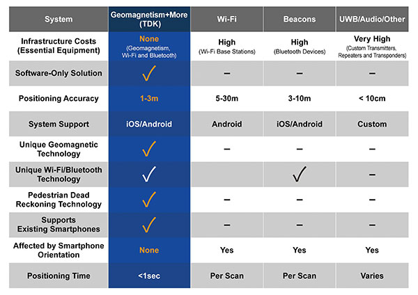
Indoor location information can be obtained using various wireless communication technologies including Wi-Fi, Bluetooth and ultra-wideband (UWB). For example, Bluetooth beacons have been deployed at commercial facilities to enable services that provide location-relevant information to customers with smartphones. The positioning accuracy of Bluetooth, however, is only around 3 to 10 meters and is dependent on infrastructure installation.
To be useful for contact tracing of infectious diseases, the number of beacons must be increased to achieve an adequate level of accuracy. UWB technology features high positioning accuracy, but deployment in a wide area would require installation of a large number of radio transceivers and repeaters, putting it at a cost disadvantage.
Solution Based on Geomagnetism
Given this background, a solution using geomagnetism is attracting attention. TDK has developed VENUE, which displays the real-time locations of people by utilizing geomagnetic sensors found in today’s smartphones. Each indoor location has a geomagnetic signature that can be used to ascertain the position of the phone.
There are several approaches to indoor positioning, but geomagnetism, tightly coupled with inertial navigation, optimally balances accuracy, reliability and cost of deployment and maintenance.
“The beauty of geomagnetic positioning is that it works in all large venues whose structures interfere with Earth’s magnetic field, making this an infrastructure-free approach to indoor positioning that is accurate to better than 2 meters,” said Chris Goodall, founder and managing director of Trusted Positioning Inc., a TDK Group Company based in Calgary, Alberta, Canada.
VENUE provides a position display with even higher accuracy by combining geomagnetic information with information from accelerometers and gyroscopic sensors inside smartphones.
VENUE requires only the creation of a geomagnetic map that combines an indoor layout map with the geomagnetic data of that particular location acquired through a survey, with no need to install new devices and terminals. This leads to low installation cost. The accuracy of positioning using geomagnetism is better than two meters (6 feet) — sufficient for tracing contact with infected persons. In addition, VENUE provides a position display with even higher accuracy by combining geomagnetic information with information from accelerometers and gyroscopic sensors inside smartphones.
“People may hold their smartphones while walking or put them in their pockets or bags,” Goodall said. “Since the orientation to the user changes constantly, the movements and pedestrian use cases need to be corrected using inertial sensors. Solving these issues was the greatest challenge for practical applications such as tracking, and took our team many years to create, perfect and protect.”
Comparison of indoor location information technologies. (Chart: Trusted Positioning)
Real-World Trial Under Way
Beginning in August, a contact tracing trial among workers is being conducted at TDK’s headquarters in Nihonbashi, Tokyo, using VENUE. Employees carry smartphones with a special app installed, and their positions and movement histories on the floor are combined with anonymous identification information. If an employee is found to be infected, the data will be analyzed to identify people who had contact with that employee within the preceding two weeks, and measures such as stay-at-home instruction will be taken.
This solution not only can identify those who were in close contact with the infected person as primary contacts, but also trace those who stayed in areas where the infected person had been shortly before as potential “area contacts.” Analysis that combines location and elapsed time enables more effective contact tracing by improving primary contact tracing indoors and enabling area-based contact tracing over time.
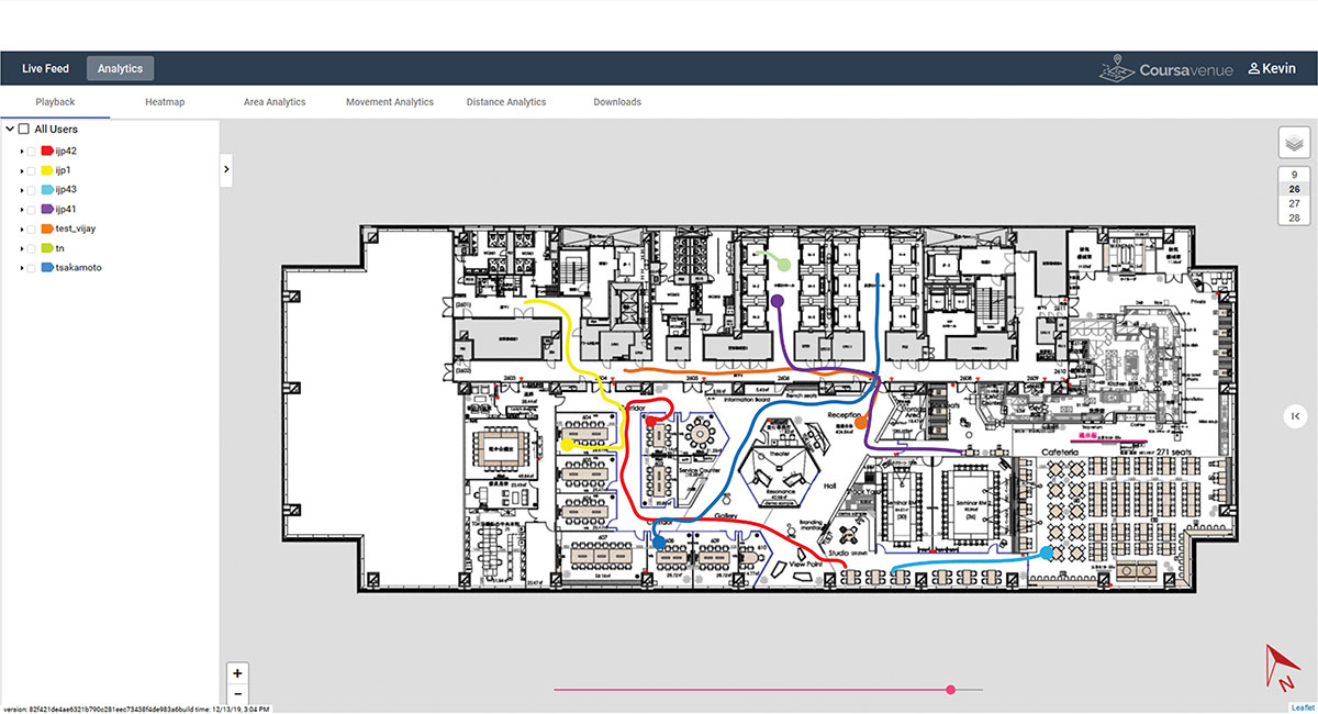
Ongoing Trial at TDK Headquarters: VENUE displays an individual worker’s tracking data on the dashboard. (Conceptual illustration: Trusted Positioning)
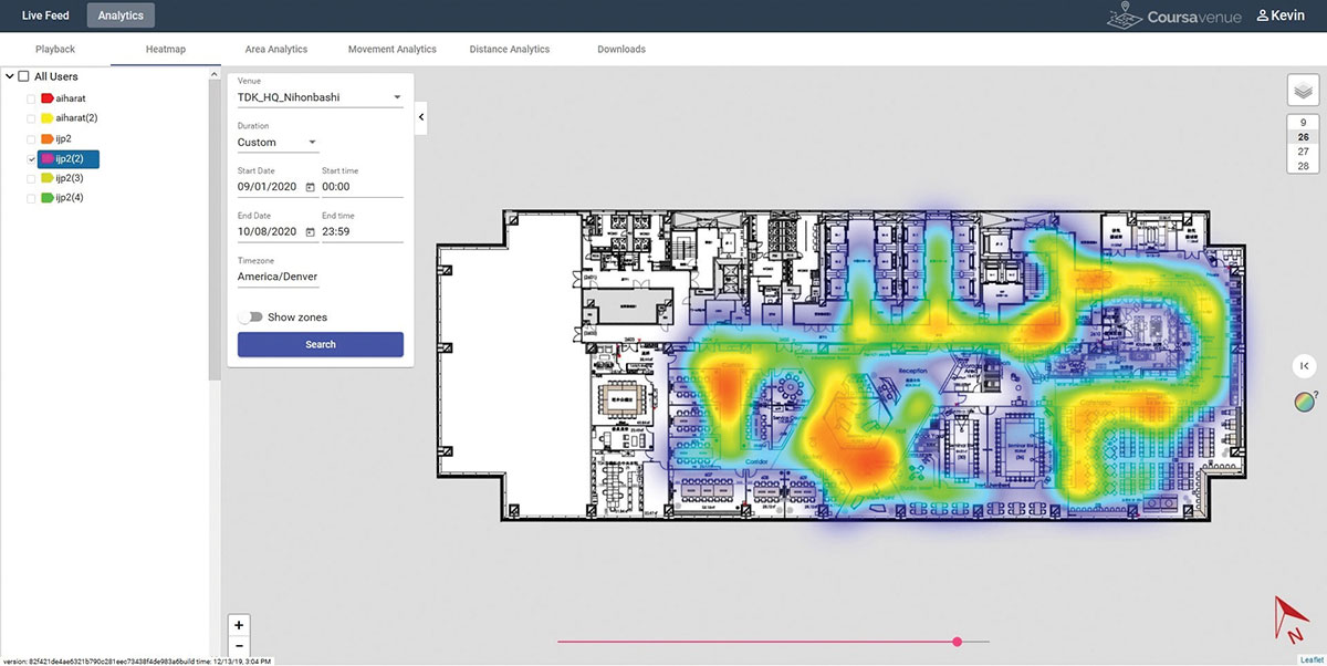
Ongoing Trial at TDK Headquarters: A worker’s durations of stay and positions can be visualized in the form of a heat map. (Conceptual illustration: Trusted Positioning)
New Possibilities Opened
Because VENUE can display the positions and histories of people and objects using not only workers’ smartphones but special tags containing geomagnetic and inertial sensors (under development), it can be deployed for a wide range of applications beyond contact-tracing of infectious diseases. Possible uses include monitoring the flow of employees to improve operational efficiency or tracking positions of equipment to manage their operational statuses. TDK is working with a number of companies on solutions to improve business efficiencies using location information.
Many offices have introduced open seating, so maintaining a “real-time seating chart” using VENUE is a real advantage so staff can more easily find one another in large office settings, encouraging more collaboration between staff and departments.
Companies have been using Bluetooth low-energy (BLE) beacons to manage the movement of workers, materials and equipment indoors in warehouses, factories and construction sites. VENUE can reduce the installation and maintenance costs of such systems, especially in large-scale facilities.
VENUE is also useful for other contact-tracing applications that do not focus on viral transmission, such as human-to-machine, human-to-vehicle and human-to-robot contacts. The future work environment will undoubtedly change with more automation, and the interaction of humans and machines poses safety concerns. VENUE’s designers hope it can improve safety in many types of contact-tracing applications.
Similar to the expansion of GPS for outdoor positioning applications, indoor positioning technologies will likely grow in our everyday lives. VENUE is one indoor location information solution that enables highly accurate location information to be obtained while keeping infrastructure costs down.
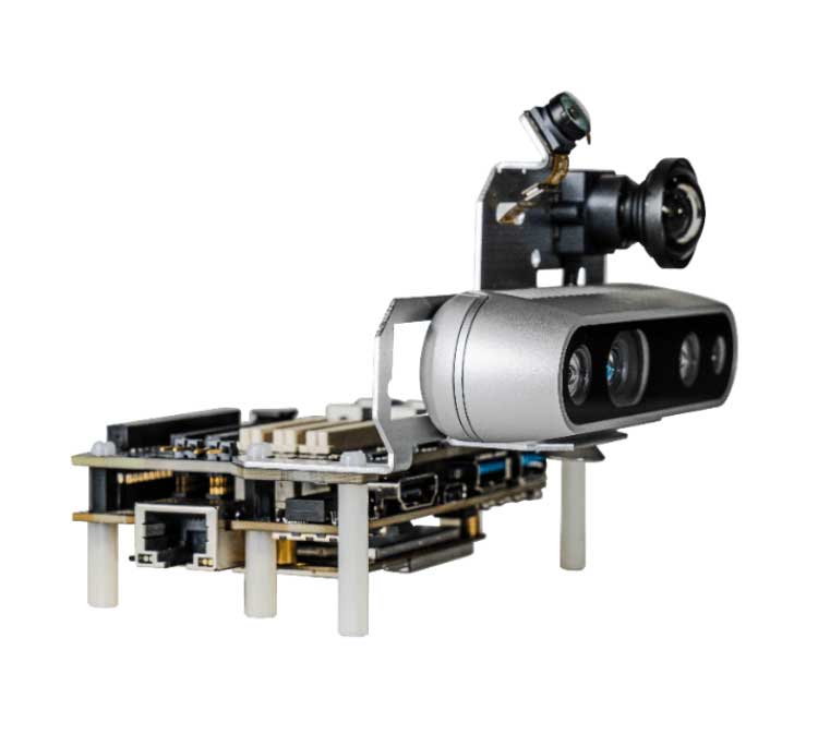
The Qualcomm Robotics RB5 Development Kit (Photo: Qualcomm Technologies)
Qualcomm Technologies released the Qualcomm Robotics RB5 platform. The RB5, comprised of hardware, software and development tools, is designed for the consumer, enterprise, defense, industrial and professional service sectors.
According to the company, the platform’s Qualcomm QRB5165 processor offers a heterogeneous computing architecture, coupled with the fifth-generation Qualcomm AI Engine that delivers 15 tera operations per second of artificial intelligence (AI) performance for running complex AI and deep learning workloads. The processor also offers incredible machine learning inferencing at the edge under restricted power budgets using the new Qualcomm Hexagon Tensor Accelerator.
Technical features of the RB5 include heterogeneous computing capabilities, 5th generation Qualcomm AI engine, advanced imaging capability, security support and connectivity. Qualcomm’s Spectra 480 Image Signal Processor (ISP) captures fast, professional-quality photos and videos, and can process two gigapixels per second, the company said.
In addition, seven concurrent cameras facilitate simultaneous localization and mapping (SLAM), object detection and classification, autonomous navigation and path planning to perform tasks in indoor and outdoor settings.
With the Qualcomm Robotics RB5 platform and the Qualcomm QRB5165 processor, Qualcomm enables various design offerings including off-the-shelf system-on-module solutions and flexible chip-on-board designs, the company said. The solution is available in multiple options, including commercial and industrial-grade temperature ranges and an option for extended lifecycle until 2029.
“With the Qualcomm Robotics RB5 platform, Qualcomm Technologies will help accelerate growth in a wide array of robotics segments such as autonomous mobile robots, delivery, inspection, inventory, industrial, collaborative robots and unmanned aerial vehicles, enabling Industry 4.0 robotics use cases, and laying the foundation for the UAV Traffic Management space,” said Dev Singh, senior director, business development and head of autonomous robotics, drones and intelligent machines at Qualcomm.
Qualcomm also has entered into a strategic collaboration with TDK to further enhance the capabilities of the Qualcomm Robotics RB5 platform. Through the partnership, TDK added its latest sensor technologies for enhanced robotics applications as part of the Qualcomm Robotics RB5 platform.
The Qualcomm Robotics RB5 Development Kit
In addition, Qualcomm Robotics RB5 Development Kit ensure developers have the customization and flexibility they need to make their visions a commercial reality.
According to Qualcomm, the kit allows developers to have flexible software capabilities, with the platform offering support for Linux, Ubuntu and Robot Operating System 2.0, as well as pre-integrated drivers for various cameras, sensors and 5G connectivity. It also provides support for OpenCL, OpenGLES and OpenCV.
It also includes support for the Intel RealSense Depth Camera D435i and Panasonic TOF Camera to provide depth-sensing capabilities. TDK’s six-axis ICM-42688-P IMU, ICP-10111 barometric pressure and T5818 Digital bottom port microphone are integrated into the kit, as well.
TDK’s booth at the Consumer Electronics Show (CES) is in South Hall 3, Booth #30306, and offers a look at sensors, passive components and more from TDK and its group companies. (Photo: TDK)
TDK Corporation has launched its InvenSense Coursa Drive software, an inertial-aided positioning solution for autonomous vehicle platform developers.
A high-performance extension of the InvenSense Positioning Library (IPL) that has provided sensor-aided positioning to more than 50 million devices worldwide, Coursa Drive enhances inertial-only vehicle positioning to <0.2 percent of distance traveled. These precise levels of accuracy are critical to maintaining decimeter lane-level vehicle positioning in challenging GNSS/perception system environments.
Coursa Drive’s inertial navigation system (INS) calibrates using absolute position inputs from either high-accuracy GNSS receivers or from perception-based systems (camera, radar, lidar) with high-definition (HD) maps.
In real time, Coursa Drive provides high-rate, 100 Hz delta positions and orientation to the autonomous vehicle (AV) system, complementing the lower-rate position references from GNSS and perception systems.
For improved system fault-tolerance, Coursa Drive can provide decimeter position precision for short periods when the GNSS or perception systems are uncertain or unavailable.
For non-real-time applications such as HD map creation and maintenance, Coursa Drive’s offline mode reprocesses INS data at two to three times higher accuracy than real-time mode, providing HD map companies alternative position references to verify HD map accuracy, even without GNSS, for up to 60 seconds.
“Coursa Drive delivers vehicle dead reckoning accuracy equivalent to high-end systems costing thousands of dollars,” said Mike Housholder, senior director of the TDK InvenSense Location Software and Services Business. “Our cost-effective software solution will help AV platform and Tier 1 vehicle manufacturers scale beyond prototype vehicles to high-volume mass production.”
Coursa Drive provides autonomous vehicle platform developers with maximum flexibility for system integration. The solution is platform agnostic and can operate on Cortex-M4F-class microcontrollers, or higher, and supports most dual-frequency GNSS receivers. The Coursa Drive API specifications are available upon request.
Coursa Drive is thoroughly tested and characterized using the InvenSense line of automotive-grade IMUs, including the IAM-20680 and IAM-20680HP, as well as several industrial grade IMUs. Coursa Drive is available now for select early partners and customers.
TDK and its group companies offering a comprehensive portfolio of sensors, electronic components and solutions for mobile, wearables, AR/VR, automotive, IoT and industrial applications will be at CES 2019, showcasing the Coursa Drive solution, along with additional innovative sensor solutions, in Booth #30306, Las Vegas Convention Center, South Hall 3, Jan. 8-11, Las Vegas.
Main applications
Level 2 to Level 5 advanced driver-assistance systems (ADAS)
Robotaxis
Trucking
Precision agriculture
Key features
World’s first high-precision inertial-aided positioning software for AVs
Inertial-only decimeter precise positions provided during short GNSS or perception system outages/uncertainties
High-rate, 100 Hz position and orientation updates supplied to the AV system
GNSS-agnostic software solution offers flexible integration for full-stack AV solution providers
Unique offline mode further enhances accuracy by two to three times for HD map building and maintenance applications.
TDK, a manufacturer of electronic components, and OriginGPS, a manufacturer of miniature GNSS modules, are collaborating to maximize GNSS performance in small devices such as wearables.
As part of the collaboration, customers using OriginGPS Spider modules will receive increased support to integrate TDK antennas into their designs, including existing reference designs coupled with TDK’s extensive electromagnetic simulation capabilities on GNSS performance.
“TDK is one of the most well-respected names in the RF industry, so it goes without saying that we’re very excited to be working with them to provide best-in-class location modules to their customers,” said Gal Jacobi, CEO of OriginGPS. “By joining designs of our products with TDK’s small form-factor chip antennas, customers will be able to get a firsthand understanding of how our GNSS solutions pack the world’s smallest footprint and add functionality to a wide range of wearables and other Internet of Things devices that require low-profile miniaturized chip antennas.”
The collaboration pairs OriginGPS’ smallest GNSS receiver modules, including the recently unveiled Multi Micro Spider, with the tiny chip antennas by TDK to deliver a “mini + mighty” solution for wearables that combines TDK’s specialized RF simulation capabilities with OriginGPS’ GNSS expertise and support.
The collaboration also benefits OriginGPS customers, the companies said. Those who purchase Spider product line modules for their wearables can now use them in conjunction with TDK antennas to meet specific requirements while minimizing design time, and receive TDK’s support for antenna matching and simulations.
“The combination of TDK’s small chip antennas along with OriginGPS’ GNSS receiver modules provides customers the best solution to miniaturize their products,” said Tuomo Katajamaki, Product Manager, RF Components of TDK. “Now customers can effectively see for themselves the advanced location capabilities that are possible by pairing OriginGPS’ GNSS modules with our omni-directional antennas, creating a unique solution for wearable applications that balances efficiency with our small form factor.”