TerraGo unveiled Publisher for Raster, an application for publishing geospatial raster maps and imagery as GeoPDF documents for use with TerraGo Toolbar.
According to TerraGo, information otherwise locked away in arcane geospatial raster formats can be made available to a much wider audience as GeoPDF documents that can be measured, analyzed and annotated with TerraGo Toolbar.
The new release, version 7.1.0, features an improved output naming scheme when processing CADRG and other RPF formats with multiple images. It also reports the same application version number for the online help, processing data using the command prompt, using version, user interface and the installer. Finally, it now pulls the WKT from the GCP tag when the WKT is not listed in the standard
tag.
Version 7.0.4 adds support for Windows Server 2016 and Server 2019. It also addresses installation and license activation issues seen on some systems, TerraGo said.
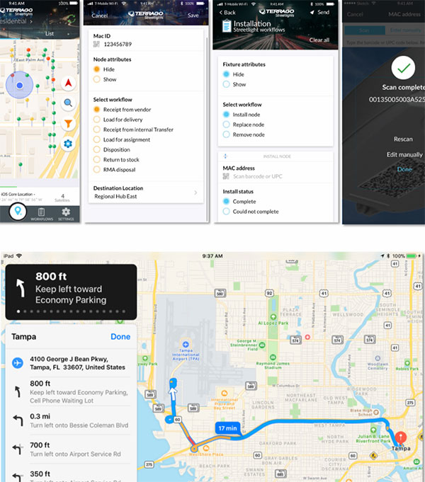
TerraGo, a provider of mobile workforce collaboration solutions, has launched a new version of its TerraGo Streetlights platform, which is designed specifically for smart streetlight projects and includes several field-tested, customer-driven and customizable features that help accelerate savings and lower full life cycle support costs.
According to TerraGo, Streetlights is fully-integrated with Itron’s leading smart city management software, Streetlight.Vision, and is being utilized on a number of high-profile smart streetlight projects in locations around the world, including Chicago.
The platform’s latest features, which are all configurable and customizable with zero-code, include automated node commissioning with Itron’s Streetlight.Vision, full inventory chain-of-custody management, MAC address validation, integrated GPS location and proximity detection, advanced mobile app search, custom map symbology, installation status maps and reports, automated workflow updates, crew assignments, task notifications, one-click workflows, configurable asset cards, customizable operational reporting-as-a-service and more.
According to TerraGo, smart streetlights provide a measurable return on investment to cities by helping them achieve massive reductions in energy costs, carbon dioxide emissions and maintenance expenses — all while laying the open network foundation for smart city applications like traffic management, air quality, noise management and crime prevention. TerraGo Streetlights helps cities and utilities complete projects and really savings sooner, thus increasing the total return on investment while enabling future smart city applications, the company added.
“TerraGo Streetlights’ features are customer-driven from lessons learned on real-life projects, so we can improve efficiency in every phase from planning and inventory to installation and maintenance,” said Dave Basil, president and CEO of TerraGo. “We believe in being super-focused on our customers’ work, so we can deliver software that makes a real impact for these projects. We even embed our software architects and UX designers with work crews in the field, so we can learn firsthand how to minimize task times, prevent errors and get the job done right the first time.”
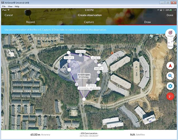
TerraGo, a provider of dissemination and collaboration software for defense and intelligence agencies, has announced the availability of R3 for immediate download in the National Geospatial-Intelligence Agency’s (NGA) GEOINT App Store.
R3 is a mobile data collection and collaboration app customized for the missions of reconnaissance, response and recovery. Designed for the most challenging missions and environments, R3 lets users keep working offline and off the grid with customizable workflows for security, humanitarian and disaster relief programs, the company said.
“R3 enhances situational awareness, search and rescue, damage assessments and recovery efforts,” said Scott Lee, director of federal programs at TerraGo. “It really gives users the best of both worlds with mobile technology that can go anywhere, and will also work even when the network doesn’t.”
Image: TerraGo
Designed with a simplified user interface, R3 provides a robust standalone capability for a variety of field-based collection activities. Users can access custom basemaps from numerous GIS, map and imagery sources including GeoPDF, ArcGIS, USGS and GXP, while collecting and exchanging location-tagged notes using smart forms, photos, videos and audio files.
Pre-loaded forms are available for structured assessments, and users can connect to a secure server to create unique mission packages and enable synchronous collaboration. R3 supports important standards like OGC GeoPackage interoperability and sharing geospatial assets among mission partners.
Registered GEOINT App Store users can download TerraGo R3 for iOS here. The Android version is complete and coming soon, the company added.
The application, built using the TerraGo Magic platform and available today from BAE Systems, offers iOS, Android and web apps that make it easy to securely capture and share field reports from any location.
With GXP InForm, users can customize forms, maps and workflows so field applications can be quickly configured and instantly deployed to support any operation, in any location.
GXP InForm’s mobile features, including basemaps and forms, are available without network connectivity so personnel can get the job done in the most remote locations and demanding conditions. When a network connection is available, GXP InForm enhances situational awareness for all stakeholders with the bi-directional flow of information between headquarters and on-site personnel.
“We constantly look for ways to help our customers extend the value of GXP Xplorer across the enterprise and improve the quality of geospatial intelligence for all stakeholders,” said Damon Brady, director, product development and programs at BAE Systems. “With GXP InForm, mobile users get access to actionable imagery, while command units gain access to site reports, photos and videos that enhance the fidelity of their common operating picture.”
“We’re proud of this collaboration to build GXP InForm,” said Dave Basil, president and CEO at TerraGo. “It’s the result of a long-running and successful partnership with BAE Systems that goes back to 2008. The combination of GXP Xplorer, as an open data-management platform, and GXP InForm, as a customizable reporting application, provides great value to our customers that need to leverage vast geospatial data sources and tailor field workflows to all types of operations and missions.”
TerraGo is offering a webinar at 1 p.m. ET on Feb. 21, with a discussion and demonstration of GXP InForm. Register here.
The GPS World staff is reporting from Intergeo Sept. 26-28 in Berlin, Germany. The massive trade show, dubbed the “global hub of the geospatial community,” brings together more than 17,000 visitors from more than 107 countries and features approximately 525 exhibitors. Check out some of the latest industry news, as well as photos and videos from the event.
TerraGo is exhibiting at Intergeo 2017, which is taking place Sept 26-28 in Berlin, Germany.
“Intergeo brings together the global leaders of the industry and creates an exceptional forum for interpersonal collaboration and the opportunity to show the industry’s only zero-code platform to visitors from nearly 100 countries,” said Stuart Miller, international sales manager at TerraGo. “The event gives us a chance to dialogue and understand our visitors’ goals before we demonstrate our technology. Then by understanding their specific objectives, we can show them how to customize geospatial apps for their unique requirements.”
TerraGo’s GeoPDF products enable free, lightweight GIS applications and have evolved into a de facto standard around the globe, helping organizations get more value — for more users — from their current investments in GIS and imagery platforms, the company said.
Also, TerraGo Magic enables end users without development skills to build custom apps that enable high-accuracy, survey-grade GNSS with advanced GIS and mapping features on Android and iOS devices.
TerraGo’s exhibition will be located at the UK Pavilion, Hall 1.1, Booth D1.016. Click this link to schedule a time for a live demonstration.
TerraGo partnered with Western Data Systems (WDS), a provider of field data collection solutions to the surveying, construction and other infrastructure industries.
In alignment with the partnership, WDS will launch P.L.A.N.I.T. (Points, Lines, Areas, Navigation, Information, Tasks), a mobile data collection platform built entirely using TerraGo Magic.
“WDS has the experience and expertise to give customers the smartest, most cost-effective solution to meet their needs,” said John Timar, vice president of worldwide sales for TerraGo. “The combination of the best positioning technology and a fully customizable app will help their customers get field work done faster, better and cheaper than ever before.”
A number of geospatial intelligence companies are exhibiting at the GEOINT 2017 Symposium, which is taking place June 4-7 at the Henry B. Gonzalez Convention Center in San Antonio, Texas.
Hosted and produced by the United States Geospatial Intelligence Foundation (USGIF), the annual GEOINT Symposium is the nation’s largest gathering of industry, academia, and government to include defense, intelligence and homeland security communities as well as commercial, federal, civil, state and local geospatial intelligence stakeholders.
The event annually attracts more than 4,000 attendees from all over the world, with more than 250 exhibiting organizations and more than 50 hours of training sessions for attendees.
The theme for GEOINT 2017 is “Advancing Capabilities to Meet Emerging Threats.”
Companies planning to exhibit:
TerraGo will be demonstrating its R3 mobile app, customized for the missions of reconnaissance, response and recovery and built entirely using TerraGo Magic, a zero-code platform that enables customers to build apps tailored to their unique operations with web services, custom map products, imagery, forms and workflows.
Red Hen Systems will showcase its surveillance technology. The company’s Digital Mapping Reconnaissance Toolkit Exportable (DMRT-EX) and MediaMapper Mobile Android app have been used by law enforcement military and civilian members around the world for anti-narcotics operations, vegetation management and other surveillance missions.
Visit Booth 333 at GEOINT to see the company’s equipment in action.
Descartes Labs Inc., a cloud-based geospatial analytics company, will unveil its global-scale machine learning platform. The platform powers geographic and temporal analysis of remote-sensing data to identify objects, forecast change and deliver high-performance intelligence solutions.
GEOINT attendees can learn more about Descartes Labs at booth #1325 in the GEOINT Exhibit Hall. Descartes will also present a Lightning Talk at GEOINT Forward on Sunday, June 4, and a training workshop on Tuesday, June 6.
The Polaris TLS by Teledyne Optech
Teledyne Optech will showcase the advanced capabilities of the award-winning ALTM Galaxy T1000, now featuring a 1-MHz laser PRF, PulseTRAK and SwathTRAK technologies for a universal sensor that surpasses larger systems with consistent, ultra-dense data and measurement precision and accuracy.
In addition, visitors will see the new Polaris Terrestrial Laser Scanner (TLS) for ground-based survey applications. With an integrated high-resolution camera, inclinometers, compass, GPS receiver, and weather-proof housing, the Polaris can be deployed in many environments and orientations.
Visit Booth 1767, where sustaining USGIF Member Teledyne Optech will be joined by Teledyne DALSA, Teledyne Imaging Sensors, and Teledyne Brown Engineering to represent a broader range of Teledyne’s capabilities and solutions for GEOINT/ISR applications, including lidar, EO, IR and hyperspectral imaging.
Esri will be showcasing mission-focused enhancements using the ArcGIS platform for defense, intelligence and national security workflows.
ArcGIS provides high-performance 2D and 3D analysis for defense, intelligence, and national security. It is a complete and open platform for managing, analyzing, and sharing data and data products. ArcGIS leverages big data, web technologies, and integrated apps to make location-based data easy to use, more accessible, and collaborative.
“GEOINT and geographic information system [GIS] technologies have never been more important to the intelligence community,” said Ben Conklin, Esri head of industry, defense, and intelligence. “We are looking forward to the annual GEOINT Symposium, since it gives us a great opportunity to demonstrate the latest advances in GIS technology. The event also gives analysts access to tools that provide quick, responsive, and interactive experiences for increased productivity and support of decision-making and operations at every level.”
Esri will offer the following demonstrations at Booth 615:
Advancing The Science of Where
Reveal Deeper Insight through Analytics
Unlock Your Data with Apps
Open Platform for Intelligence
The Esri Presentation “Geospatial Intelligence Using a Web-Enabled GIS” takes place Tuesday, June 6, 2 p.m., 007C River Level.
East View Geospatial (EVG), a provider of content-rich cartographic products, continues to enhance the accuracy of automated feature identification using its newly developed training data sets in supervised machine learning applications. The early results pertained to automated recognition of building structures in an ongoing pilot project in Papua New Guinea (PNG).
“Our goal is to create a state-of-the-art process that produces the highest quality training data available for the users and developers of supervised machine learning technology,” said Rod Buhrsmith, business eevelopment at EVG. “In just a few months, we have made significant progress and expect to push the accuracy even higher.”
EVG will be available to discuss the PNG pilot in private meetings at GEOINT (contact Rod Buhrsmith at [email protected] or Mark Knapp at [email protected] or call 1-952-252-1205.)
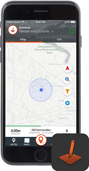
The profession of land surveying has taken advantage of many technological location and measuring advancements, yet most of the data collectors used today are still based upon aging proprietary data collectors and even older operating system platforms.
A common tool for most surveyors is the smartphone or tablet, so TerraGo developed an application that takes advantage of the nimble programming of iOS and Android.
The TerraGo Edge 4 mapping application utilizes all the best features of today’s mobile technology, according to TerraGo. Besides an intuitive interface, Edge 4 allows users to customize how their data is collected and presented, including overlays on Google and Apple maps.
Depending on the user’s needs, Edge 4 can use the device’s Bluetooth connection to an external GNSS receiver for greater accuracy.
Sharing is also easy with publishing and ArcGIS exporting plug-ins, all in a mobile environment most users are familiar with using every day, the company said.
GPS and GIS features include:
Sub-meter and centimeter precision
Real-time GPS monitor
Full NMEA GPS metadata display and capture
GPS accuracy settings
RTK support
Dynamic BT device list
Auto-record GPS Lines and Polygons
Import and export Esri file geodatabase, Shapefile, KML, CSV, JSON
TerraGo Edge version 4.0 offers a completely redesigned app based on customer feedback, field user observations and task-centered design cycles, as well as a host of new features including the addition of Google and Apple basemaps.
“The new interface is so much more than just a ‘look and feel’ change; it will allow us to more efficiently execute projects and improve data quality in less taps and less time, which is a force multiplier when you’re talking about thousands of data points per day,” said Scott Riccardella, director of oil and gas business development at Structural Integrity Associates. “Having the right tool is essential to getting any job done right, and TerraGo is ahead of the game when it comes to giving my field teams the best possible tool for the fastest, most accurate and highest-quality asset inspections.”
“We have completely rebuilt the mobile user interface from the ground up to improve all aspects of the app’s performance, and while users will notice the stunning graphics and aesthetics, the real value is that the feature or data you need is always just one tap away,” said Dave Basil, vice president of product development at TerraGo. “By incorporating the latest native design elements like tabbed navigation, responsive split screens and adaptive list views, we found ways to improve the speed and efficiency of the work our customers do every day.”
TerraGo Edge’s latest features include:
Reimagined user experience: Rebuild of the Edge mobile user interface incorporating both years of user feedback from the field and interactive design cycles with live users.
Google and Apple maps: Standard, satellite and hybrid maps are available for data collection and are paired with new precise location pin icons for a cutting edge data collection experience.
Tabbed app navigation: With the new, easier to reach tabbed navigation, it’s easier to collect data in the field.
Quick capture button: Allows users to create notes, complete forms, take photos, drop points and draw lines/polygons from virtually anywhere in the app, with only one tap.
Unlimited attachments: Now users can attach as many forms, photos or videos as you would like to a single note.
Responsive split screen view: When holding a tablet or larger mobile device in landscape mode, new split screens will automatically allow userse to view lists/maps or lists/details on one screen.
Detailed list view: The new detailed list view shows more of the important note data making it easier to find notes, and enables one-tap actions directly from the list.
One-tap forms and maps lists: Now users can view all the form templates, and instantly create notes using them, or view all your offline maps and directly access them, from one master list.
Precise location: Users can capture a more accurate location when creating notes by using the center crosshair target and coordinate level accuracy for dropping points and drawing lines/polygons.
Filter by map extent: This new feature keeps the notes on a map and in a list dynamically in sync.
Quick basemap preview: Preview online and offline basemaps in real-time from the selection screen to choose a map with one tap and no toggling back and forth.
Arc2Edge plug-in: ArcGIS Desktop users can directly share maps and features with mobile users, allowing them to roundtrip updates and new features from the field back to ArcGIS.
TerraGo Magic, a custom app designed for both iOS and Android platforms, simplifies the process of designing a custom application for specific clients and needs.
With TerraGo Magic — now available in version 2.0 — an organization’s end users can rapidly build cloud-enabled iOS, Android and web apps, customized with their unique branding, workflow and features, without the expense of mobile software development, maintenance and operations.
Surveying firms can install the tool in their mobile devicew to enable the specific collection and sharing of important data that can vary as needed. This data can overlay Google and Apple Maps and allow attachments of images and video. Overall, the app avoids the time-consuming coding process, and could significantly improve work flow for many firms.
Distribution for the customized app is through the App Store for iOS and Play Store for Android.
“TerraGo Magic means we can assemble different apps with exactly the features the customer needs at the click of a button,” said Ben Chadbourne, project coordinator at Ameresco. “With the latest version, our end users have even more flexibility and visibility into the app they’re building. Not only can they turn features on and off, but they can preview the app instantly from the app studio, allowing them to publish a custom-built app without having developers build it from scratch.”
“TerraGo Magic is really about flipping the script on the app development backlog by enabling end users to assemble apps with proven features, exposed as configuration options in an easy-to-use interface,” said Dave Basil, vice president of product development at TerraGo. “It’s the power of the ‘write once, reuse many’ adage, but instead of limiting the user base to professional developers, we’ve extended it to enable masses of end users to build their own apps, creating a productivity play for the entire enterprise.”
TerraGo Magic features are operationally proven from a global customer base and field-tested across numerous industries for all types of workflows including data collection, mapping, asset management, inspection, survey, remote workforce management, dispatch, customer service, mobile forms, field reporting, advanced GIS, high-precision GPS and other field operations.
Register now for a GPS World webinar on May 25 to learn more and see a live demonstration of how TerraGo Magic can build a custom enterprise app from start to finish in minutes.
While change is constant, one thing that has become standard is the use of handheld mobile devices. Smartphones and tablets are used by almost everyone and the professional surveying community is no different. The process of data collection for specific purposes often needs to be tailored to each project type, yet traditional surveying methods are not flexible in allowing customization easily.
TerraGo Magic, a custom app designed for both iOS and Android platforms, simplifies the process of designing a custom application for specific clients and needs.
Surveying firms can install this tool in their mobile device to enable the specific collection and sharing of important data that can vary as needed. This data can overlay Google and Apple Maps and allow attachments of images and video. Overall, the app avoids the time-consuming coding process, and could significantly improve workflow for many firms.
Distribution for the customized app is through the App Store for iOS and Play Store for Android.
A free webinar on Thursday, May 25 covers the TerraGo Magic App Platform-as-a-Service, which enables anyone to rapidly build private-label, custom Trimble apps without the expense of traditional app development and without writing any code. Users don’t need hours of training or professional development skills to do it. Using a zero-code enterprise app platform, users can create, build and deploy custom mobile app for any industry or workflow in minutes.
• creating custom mobile apps with branding and selected features using a click app studio
• integrating custom mobile apps with Trimble GNSS and many other enterprise platforms
• publishing to the AppStore, Google Play and the cloud with
• deploying cloud-based or private-hosted enterprise servers
• reducing development costs
TerraGo has entered a partnership with Duncan-Parnell, a provider of geospatial solutions to the surveying, construction and other infrastructure industries in Delaware, Washington, D.C., Georgia, Maryland, North Carolina, South Carolina, Tennessee, Virginia and West Virginia.
“Our customers depend on Duncan-Parnell to provide innovative, reliable solutions for their geospatial and infrastructure management needs,” said York Grow, MGIS Solutions Manager at Duncan-Parnell. “Because TerraGo apps provide direct integration with Trimble receivers, they can help us deliver the best of both worlds for customers with an easy-to-use field app and proven Trimble accuracy.”
“Duncan-Parnell provides the expertise and level of service that complements our mobile technology to help our customers complete projects on time and on budget,” said John Timar, vice president, Worldwide Sales, TerraGo. “The latest Trimble GPS and positioning technology combined with our user-customizable apps means they get their field work done faster and cheaper, with the precision they already know and trust.”
Duncan-Parnell specializes in providing high quality hardware, innovative software, and invaluable services to make projects successful. With 13 locations to serve customers, Duncan-Parnell is an authorized reseller of TerraGo Edge and TerraGo Magic products in addition to Trimble, Esri and other leading geospatial technologies.
The companies are hosting a webinar at 12 p.m. ET on Tuesday, March 14 that includes a live demonstration of mobile GIS and GPS solutions available from TerraGo and Duncan-Parnell.


 TerraGo Magic