On Jan. 3, Hexagon and Dayou announced the availability of TerraStar-X Enterprise test beds in Beijing, Shanghai, Anqing and Shenzhen for OEMs in the automotive and micro-mobility industries. Terra-Star-X Enterprise precise-point positioning corrections provide lane-level accuracy with fast convergence for autonomous vehicles and mass-market use.
The availability of the test beds follows the initial announcement by Hexagon’s Autonomy & Positioning division and Dayou of their partnership aiming to deliver GNSS correction services to the Chinese market. Users of autonomous platforms will now have a single correction service that works in China, North America and Europe.
OEMs in China can now leverage the test beds with consumer and automotive-grade GNSS receivers to design advanced driver assistance systems (ADAS), and other products, such as mobile applications, safety-critical solutions and more.
Interview with Sara Masterson, Director, Positioning Services, Hexagon’s Autonomy & Positioning division, Hexagon | NovAtel
The accuracy of GNSS receivers continues to increase thanks to new satellites and signals, improved antennas, etc. How is that changing the role of correction services?
For sure, the accuracy of GNSS receivers and antennas is improving. However, most applications still require a higher level of accuracy than what is available from an uncorrected position even with the positioning improvements brought by new constellations and signals. GNSS corrections are still required to enable, say, lane-level accuracy, or sidewalk-block accuracy for autonomous driving or mobile phone applications and for off-road autonomy applications such as construction, mining, agriculture — these all still require centimeter-level accuracy that is enabled through GNSS correction services.
Corrections also help by improving the availability and reliability of a solution. In the future, corrections will play a key role in adding integrity to enable functionally safe solutions that are required for new applications, such as autonomous driving.
There are many options for corrections — local, regional and global, ground-based and satellite-based, public and private, etc. Which of them are generally best for which applications and conditions?
That depends very much on the user and the application. There are many new correction services in the market. Some are free, some are commercial services. Even now we see in agriculture that WAAS is sufficient for some broadacre-type applications. So, we will continue to see a range of applications, some of which will be satisfied with the level of performance from a free service and others that will be looking for the better performance and service level guarantees that come with commercial services.
If something is not working when you are using a free service, there’s no one to call. With commercial services, you get responsive customer support and you pay for higher levels of performance and service availability. In many applications, especially those that involve autonomy or safety applications, you cannot afford to have downtime, or your machine just stops working, which costs money. So, many applications are still going to be needing the performance and service level guarantee that commercial services offer.
How does TerraStar fit into this range of options? What industries and applications are you targeting?
TerraStar has a range of services that enable us to target many industries and applications. Agriculture, of course, is one of the key applications for our services and we have customers using TerraStar for mobile mapping, UAVs and new autonomy-based applications. We are also involved with some interesting Hexagon joint projects that use TerraStar corrections for mine train automation and surveying and construction.
Our entry-level TerraStar-L service is still better in performance to many of the free services or to an SBAS-type service in terms of accuracy, but it is available globally, including regions where you don’t have other options. It also provides better pass-to-pass and year-over-year repeatability, as well as very quick reconvergence time if there are any issues with GNSS outages.
Our flagship offering is the TerraStar-C PRO service. That’s where we just introduced the “RTK from The Sky” technology, bringing the performance down to converging to two and a half centimeters in three minutes. That, too, is available globally which makes it a real game changer for customers in many different applications, because they can start to look at that service as an alternative to RTK and without the added connectivity logistics that an RTK solution brings.
Our RTK assist solutions are good augmentation solutions for customers who still primarily need RTK but experience some RTK correction outages – RTK ASSIST bridges through those outages. So, we have a wide range of service offerings in the portfolio that can address the positioning needs of many applications.
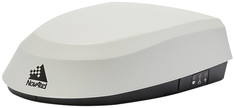
Photo: Hexagon | NovAtel
Will the reasons for having a base and rover setup decrease sharply?
Use of base and rover setups is already decreasing and being replaced by both PPP and network RTK solutions. There are applications where RTK still makes sense, such as those that have very tight vertical requirements and many survey applications. Another Hexagon division, Hexagon’s Geosystems division, incorporates TerraStar correction data into their new SmartNet Global offering as a seamless service that provides both SmartNet RTK plus TerraStar for either bridging outages or independent PPP operation, depending on the project’s location and whether they’re within range of SmartNet coverage.
There will be many applications that continue to benefit from a combination of the two technologies. However, as the PPP services, like TerraStar, continue to improve by reducing convergence time and providing highly reliable solutions, users in those applications can be confident that the standalone PPP solutions meet their performance needs and bring many additional benefits such as consistent, global coverage and performance.
Is TerraStar completely receiver agnostic?
TerraStar is currently only compatible with NovAtel’s GNSS hardware. Going forward, through the work that I referenced with autonomous driving and mass-market applications, we will be providing TerraStar services in industry-standard formats, depending on the inter-operability requirements coming from those applications. We expect that there will be demand for dual sourcing of corrections and interoperability between chipsets that are used in vehicles, for example. For those applications, we will be developing TerraStar services that are compatible with hardware from other GNSS manufacturers.
Fendt machines in North America, Europe and the Middle East equipped with Fendt Guide guidance systems powered by Fuse Smart Farming now come with NovAtel’s SMART7 GNSS receiver as the default configuration choice.
“We have been working with NovAtel for years, and their support and willingness to adapt to meet our needs makes them the key GNSS receiver supplier for our Fendt Guide guidance system,” said Bernhard Schmitz, director, FendtONE Market Readiness and Agronomy EME. “They are easy to work with and have high-quality products that integrate seamlessly into our machines.”
The SMART7 combines a powerful GNSS receiver with a precision antenna in a durable, all-in-one enclosure designed to stand up to the vibration, weather and temperature demands of harsh agricultural environments. Delivering exceptional positioning, the SMART7 is optimized to succeed in demanding agriculture and off-road applications.
Photo: NovAtel
The SMART7 uses multi L-band tracking to access TerraStar Correction Services globally, bringing repeatable centimeter-level accuracy to any application, anywhere in the world. Access to multi-frequency GPS, GLONASS, BeiDou, Galileo and QZSS signals provides better satellite availability in challenging environments.
Resiliency to radio frequency interference is ingrained in NovAtel’s hardware designs, and the company’s Interference Toolkit firmware suite provides detection and additional protection from any potential intentional or unintentional interference.
Powered by NovAtel GNSS+INS technology, the SMART7 uses an optional integrated inertial measurement unit (IMU) to provide continuous 3D positioning, velocity and roll/pitch/azimuth for deeper integration with vehicle guidance and steering systems. Additional optional features on the SMART7 include Wi-Fi and Ethernet for remote connectivity and monitoring.
BRING YOUR OWN DEVICE (BYOD) is not just an industry buzzword. It can change the way professional surveyors work every day. The idea of using a smartphone or tablet instead of a dedicated device is appealing. But is it good enough?
Surveyors and mappers are challenged with the arduous task of data collection that meets accuracy and precision standards and provides adequate attribute information for the project. Before the invention of the electronic data collector, handwritten notes in field books were the norm. Every note keeper’s style varied in content, neatness and thoroughness. Calculations for determining survey data values were completed longhand on paper and were very time consuming.
Like its personal computer counterpart, the electronic data collector was introduced in the late 1970s with minimal adoption by the average surveyor because of cost and complexity. Storage methods for the era included magnetic modules and tape; both forms of media were expensive and fragile with little storage for the cost.
Data collection was limited to numeric values only, with horizontal and vertical angles, slope distance, point number and point code being the extent of the information. Couple this process with the limited availability of printers and plotters capable of depicting the data for the surveyor’s use, and one can see why few practitioners invested in these systems.
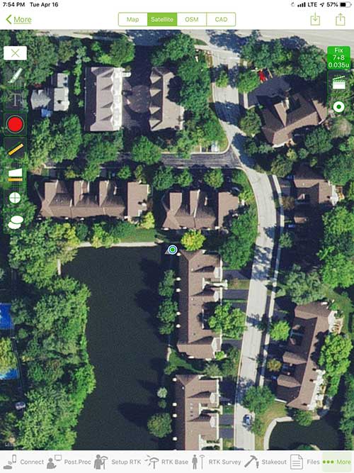
iOS aerial viewer. (Screenshot: Tim Burch)
The 1980s and 1990s brought significant changes to surveying with the advancing technology of electronic computing and measuring. The introduction of robotic total stations, various methods of GNSS, and even leveling took advantage of significant computer power and measuring processes, and the data collector stayed in lockstep with the advancing instrumentation. Almost every equipment manufacturer developed their own proprietary data collector and software system because of the unique design and programming of their systems.
In the 2000s and later, third-party manufacturers began producing data collectors with advanced computing power and the ability to connect to varying brands of equipment. Most of the programming for these collectors are still proprietary in nature to this day.
Also during the 2000s, a new wave in mobile communications was taking place. Cellular phone and data signals were now being used to transmit an abundance of information between users.
The rapid development of handheld communication devices has led to the meteoric rise of two specific mobile operating systems: one by a radical startup that concentrated on dominating the search engine market, and the other by an avant garde computer company looking to expand its unique customer base.
By the end of the decade, the world had been introduced to the Android operating system by Google, and the iOS operating system by Apple. The combined market share for the two operating systems at press time was just under 98 percent of all mobile devices worldwide.
Trending Away from Proprietary Data Collectors
Android Point Info: Confirmation of collected data, including equipment and base station. (Screenshot: Tim Burch)
Because data collection by surveyors and mappers have traditionally been performed on proprietary systems designed and produced by equipment manufacturers for use with only their instruments, these collectors, while very powerful and robust, are costly for the equipment manufacturers to produce because of the limited market of surveyors and mappers.
Many suppliers, before the introduction of the iPhone and Android operating systems, attempted to adapt their data-collection platforms to wider recognized mobile operating systems (for example, Windows CE/Pocket PC/Mobile) on a bevy of mobile devices (HP/iPAQ, Sony Eriksson, HTC) with little success. Various versions of Windows are still being used today by GNSS equipment manufacturers’ proprietary data collectors, including Trimble, Hemisphere GNSS, Topcon and CHC Navigation.
However, the field of operating environments has become more crowded as technology continues to advance. The proliferation of Windows-based data collectors are now on the decline.
Survey Point: Status of survey data collection and GNSS engine signal reception. (Screenshot: Tim Burch)
Enter Android and iOS. Driving the decline of the previously popular Windows mobile platform is the rapid adoption of the iOS and Android operating systems. These two environments have also led to a substantial number of devices and applications for users.
Part of the reason for the speedy acceptance of the devices and operating systems has been the ease of programming. It is estimated that each operating system has more than two million applications in their respective online stores, with more being introduced daily.
Because of the proliferation of smartphones, nearly everyone is familiar with the look, feel and operation of touchscreen devices and their various applications. This familiarity is driving a new trend in data collection: the concept of “bring your own device” (otherwise known in IT security circles as “BYOD”). BYOD is being introduced by several surveying and mapping equipment manufacturers as an alternative to their proprietary data-collection devices.
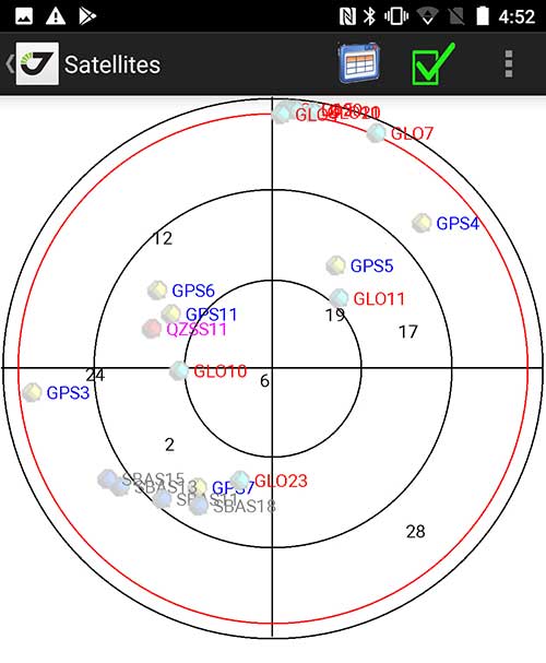
Sky Plot: Where the ‘birds’ are in the sky. (Screenshot: Tim Burch)
These manufacturers are pairing iOS and Android developers with their hardware and firmware specialists to create a user-friendly interface that will function on most of the most popular handheld devices on the market today. From Apple iPhones and iPads to Samsung Galaxy phones and tablets, these applications give the surveyor the best of two worlds — sophisticated data-collection capability on a well-known and reliable mobile operating system platform.
The Android platform is becoming especially popular in the handheld mapping market segment. Current users of this environment include Hemisphere GNSS, CHC Navigation, Tersus GNSS and Trimble.
The iOS applications, while not quite as prevalent as Android, are being embraced by several significant GNSS manufacturers, including JAVAD GNSS and Eos Positioning Systems.
These companies are creating iOS and Android apps that embrace the BYOD market, providing their users with affordability and creating a comfort level simply because of the familiarity of the device and its environment.
How Good Is It?
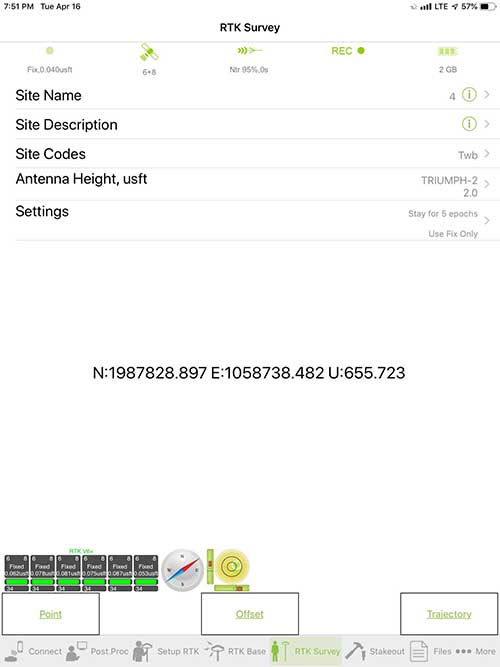
iOS Position. Status of survey data collection and GNSS engine signal reception. (Screenshot: Tim Burch)
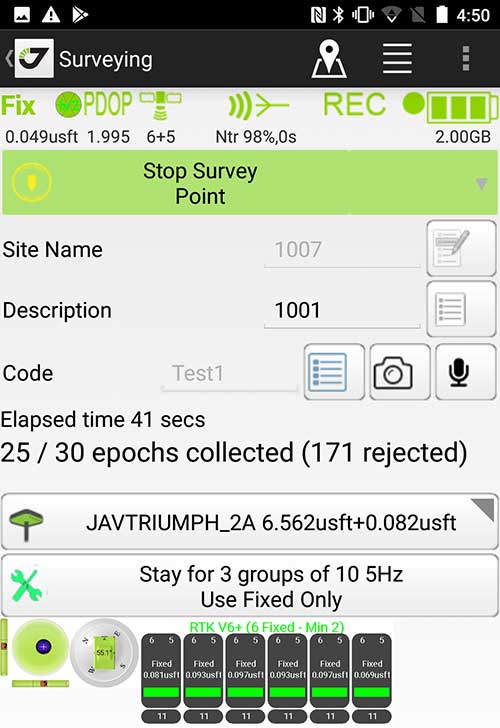
For the surveyor to be satisfied with the operation, the collection process must be efficient, cost-effective and easy to use. For this explanation of key items within a well-rounded data-collection application, we are using the JAVAD Mobile Tools (now J-Mobile) application built specifically for the Android and iOS operating systems.
The Android system (Version 7.0) was installed on a rugged CAT S41 cellphone made Bullitt Group from the United Kingdom, while the iOS app was used on the author’s iPad Air 2 running Version 12.2. Both apps were utilized in conjunction with the JAVAD Triumph-2 GNSS receiver.
After putting both versions through trial testing and checking against values on known monuments, here is the results of our findings:
Receiver Setup. Visual reference for leveling and direction of GNSS receiver. (Screenshot: Tim Burch)
Data Organization. Easy to comprehend and flexible for most naming conventions.
Corrections and Sources. Easily connects to base receiver and radio or available NTRIP correction service for real-time network (RTN) capability.
Sky Plot. Because the Triumph-2 is equipped to receive most of the available satellites in service, the Sky Plot feature is beneficial to the user for assessing potential interference.
File Management, Import and Export. Covers the typical file management and transfer functions used by the surveyor.
RTK Survey Operations. Robust telemetry keeps the users informed of specific satellite data and correction status.
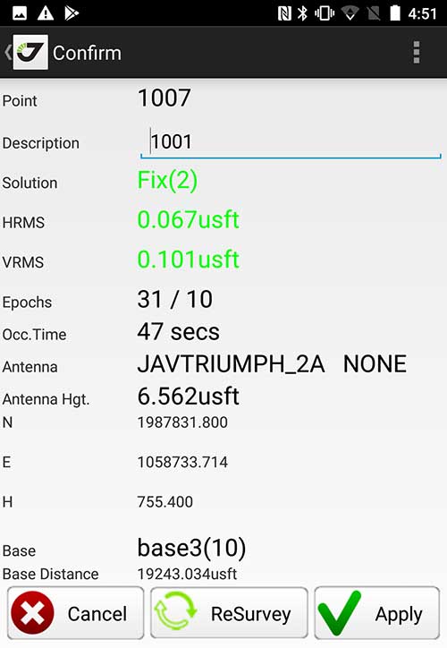
Point Confirmation. Survey point information with metadata and equipment listing. (Screenshot: Tim Burch)
Coordinate Systems. All standard coordinate systems are included with features to allow the user to customize their own systems.
Localization. Creation of a local coordinate system is a simple routine, providing strong quality checks for data integrity.
Lift and Tilt. This feature provides the user with a useful procedure to end data collection without the need to press a button. This feature significantly increases the user’s productivity.
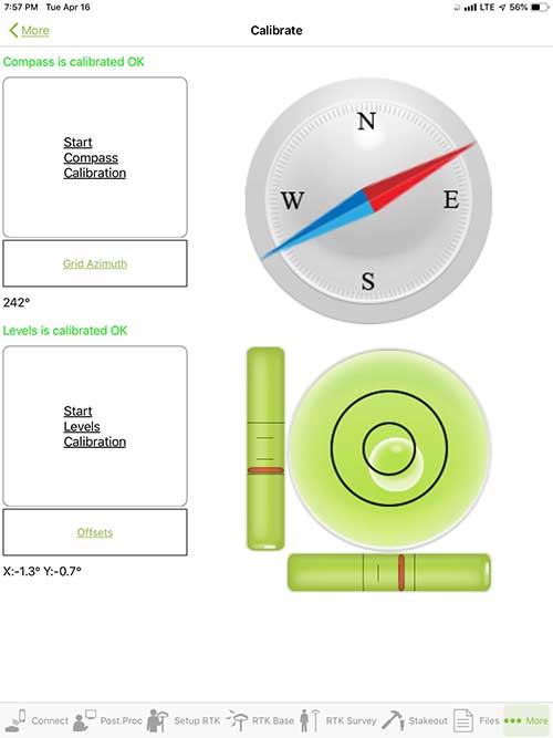
Compass and Level Calibration. With the Triumph-2 having an internal compass and level system, status of the receiver is graphically displayed to help the user keep a close watch on the accuracy of the survey point.
Survey Points and Linework. Most point naming systems and line-coding procedures are easily adapted. Total Station Point Transfer. The creation of control point files for transfer to total stations is simple and easy to use.
Stakeout. Graphical status screens provide the user with simple plotting capability of the desired stakeout point to increase efficiency and accuracy.
These apps are good at providing the surveyor with a solid tool for data collection and staking capability. They are especially good when paired with a real-time kinematic
(RTK) base station or NTRIP correction service.
But what happens when cell service is not readily available, or there are no published monument coordinates to establish site control? These apps have the surveyor covered for that situation as well.
Post-Processing (OPUS and DPOS)
Today’s surveyor works in an environment where geographic-based data is a key component to the services they render to their clients. While most of the world’s developed nations have access to cellular networks in which most GNSS receivers can communicate with an RTN providing corrective solutions, the places where this is not possible relies on other means of data correction.
In the U.S. we rely on OPUS (Online Post-Processing User System) to provide that service. But, as good as it is, it has limitations. Currently, it only utilizes GPS satellite data from the U.S. Department of Defense and is subject to sporadic government shutdowns.
Other services, from both public and private sources, are in place around the world to provide a service similar to OPUS. These include, but are not limited to:
AUSPOS. Geoscience Australia (free)
APPS. Jet Propulsion Laboratory at California Institute of Technology (free)
CSRS-PPP. Natural Resources Canada (free)
GAPS. University of New Brunswick (free)
magicGNSS. GMV (free)
Centerpoint RTX Post Processing. Trimble (free)
JAVAD Data Processing Service (DPOS). JAVAD (free, processes any JAVAD GNSS jps file)
These correction services utilize other satellite constellations (GLONASS, Galileo, BeiDou and QZSS) for their solutions and can provide additional coverage, depending on the location of the user. Because of these services, geographic-based data is at the fingertips of surveyors worldwide.
JAVAD’s DPOS system is has the ability to collect static survey data and send it to the proprietary service for establishing new coordinate values for base-station use. This process is a function of the app and can be completed in a few short steps.
Once the base station values are calculated, the surveyor can make use of this information for establishing a base station for correction broadcasting.
Do You Need a Base Station?
The establishment of RTNs has greatly enhanced surveying capability as cellular service has increased in coverage and speed. However, there are still instances and locales that do not allow for the reliable use of cell signals to provide those corrections accurately.
Various manufacturers’ tests have proven the accuracy of using an RTN subscription versus the traditional GNSS base and rover RTK setup. But cell-signal strength can be an Achilles heel, crippling those who choose not to set up a base station.
The UHF radio, even in its reduced power state from regulatory changes, is still more powerful and reliable than most cell services. 5G technology and coverage is anticipated to revolutionize cellular service, but it has yet to be realized.
Adaptation of the Industry
Other GNSS manufacturers (including NovAtel, Navcom, ComNav, Unicore, Emcore, Suzhou, TeleOrbit and Geneq) are producing receivers that can be adapted to a variety of existing data collectors and connect to iOS/Android mobile devices through various software developers.
The future of communications remains the smartphone or tablet device, with foldable units expected to be the next big thing.
As processors get more powerful, as chip memory becomes more abundant, and as more satellite constellations orbit in our sky, surveyors and their data collectors will continue to evolve. The future remains bright for technology and the surveyor has a front-row seat.
TIM BURCH is GPS World’s contributing editor for Survey. A professional land surveyor with more than 30 years of experience, he is director of surveying at SPACECO Inc. in the Chicago area. For several years he has been secretary and was recently named vice-president of the Board of Directors of the National Society of Professional Surveyors. He writes a bi-monthly column in the Survey Scene e-newsletter. Subscribe free at env-gpsworld-integration.kinsta.cloud/subscribe.
Receiver, Software Ready for Mobile
Photo: ComNav
ComNav receivers offer multiple data-collection device choices via Bluetooth connection, as well as an Android app.
For instance, the G200 provides centimeter-accuracy positioning to any connected mobile devices for RTK field surveying. It is able to delivery robust survey workflows with the SinoGNSS Android-based Survey Master, so that surveyors can collect quality high-accuracy positions no matter what mobile device they are using.
The G200 is a rugged, compact, wearable GNSS receiver. Combined with the high-performance SinoGNSS OEM board tracking GPS L1/L2, BeiDou B1/B2, GLONASS L1/L2, Galileo and QZSS, the G200 enables reliable high-precision GNSS performance for land survey tasks anywhere in the world.
TerraStar Gives Assist to RTK
Photo: Leica Geosystems
NovAtel offers several levels of corrections via its TerraStar service. For surveying applications, the RTK Assist service provides correction data to bridge surveyors through any real-time kinematic (RTK) correction outages. TerraStar services work on NovAtel’s OEM6 and OEM7 receivers..
RTK Assist, available on OEM6/OEM7 receivers, provides 20 minutes of RTK assistance, enabling surveyors to maintain centimeter-level accuracy. A higher service level, RTK Assist Pro, is available on OEM7 receivers. It provides unlimited RTK assistance with stand-alone centimeter-level positioning when RTK is not available.
Trimble Offers Web-Based Post-Processing
Photo: Trimble
Trimble’s CenterPoint RTX Post-Processing Service is a free, web-based solution that provides rigorous processing of GNSS data for users around the globe.
Powered by advanced algorithms for processing static observations, CenterPoint RTX Post-Processing supports data including GPS, GLONASS, Galileo, BeiDou and QZSS. With the service, users can upload GNSS data using Trimble formats or industry-standard RINEX 2 and RINEX 3. The service supports all dual-frequency GNSS receivers and more than 400 different antennas.
The post-processing service computes single-station static observation sessions ranging in length from 10 minutes up to 24 hours, with longer observation sessions recommended to produce the highest accuracy. Using data from the global RTX tracking network, the CenterPoint RTX Post-Processing service computes the position of the observed point with centimeter accuracy.
Results are delivered via email in ITRF coordinates at the current epoch and can be transformed to a fixed epoch by use of a standard tectonic-plate model.
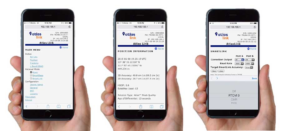
Atlas Corrections Ready for BYOD
The Atlas GNSS global correction service, offered by Hemisphere GNSS, provides correction data for GPS, GLONASS, BeiDou and Galileo constellations. Its global L-band corrections allow for accuracies ranging from sub-meter to sub-decimeter levels. The network has more than 200 reference stations worldwide and covers virtually the entire globe.
Examples of how the AtlasLink webUI looks on a smartphone. (Image: Hemisphere GNSS)
The Atlas platform was conceived to enable as many people as possible to have access to the correction service technology, either as an end-user or as part of their business. Several features are designed to enable customers who use non-Hemisphere positioning systems to have access to Atlas.
For instance, Hemisphere’s SmartLink technology allows an AtlasLink GNSS smart antenna to be used as an Atlas signal extension for any GNSS system compliant with open communication standards.
Hemisphere’s GNSS smart antennas including AtlasLink, A326, C321+ and S321+ offer a user-friendly web user interface (WebUI) that can be used to configure, monitor and manage the receiver from virtually any modern computing device, including computers, phones and tablets.
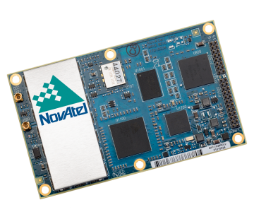
A new report describes the benefits growers can experience using NovAtel’s TerraStar-C and TerraStar-L precise point positioning (PPP) technology with a SMART6-L GNSS receiver for automatic steering.
The report, “DLG Test Report 6802, NovAtel SMART6L receiver PPP Automatic Steering Test,” was issued by the German Agricultural Society or Deutsche Landwirtschafts-Gesellschaft (DLG).
DLG promotes technical and scientific progress in the agriculture and food sectors. Set up to test equipment and machinery, the DLG Test Center Machinery and Farm Inputs provide impartial information for practitioners.
DLG awards a DLG-APPROVED quality mark to farm machinery that passes a limited test programme within a DLG usability test. Using a Fendt 828 Vario tractor, combined with the Fendt “VarioGuide RTK” steering system and the NovAtel SMART6-L receiver, steering accuracy was tested using both TerraStar-C and TerraStar-L correction services.
NovAtel’s TerraStar-C correction service provides a 5 cm or less (95%) position accuracy, and TerraStar-L provides a 50 cm or less (95%) position accuracy with a 15-cm pass-to-pass accuracy. The DLG test is designed to measure steering accuracy under various conditions as part of the criteria to receive the DLG-APPROVED quality mark.
The DLG test reported that NovAtel’s TerraStar-C correction service achieved 2-3 cm system steering accuracy on an A-B run on an even track at 8 km/h, and a 3.4 cm accuracy at 15 km/h. The long-term accuracy was reported at 3-4 cm over a 24-hour period. Also, the pass-to-pass error was less than 3 cm over the duration of an hour.
The DLG test reported NovAtel’s TerraStar-L correction service at 17-18 cm accuracy during an hour A-B run on an even track at 8 km/h, and 10-11 cm accuracy on a contour run at 5 km/h. The pass-to-pass error remained below 15 cm for the duration of the tests.
NovAtel’s SMART6-L was awarded the DLG-APPROVED quality mark after successfully completing the PPP autosteering test.
Septentrio has released version 4.2 firmware for the AsteRx4, AsteRx-U and the newly launched AsteRx-m2. The 4.2 firmware brings higher output rates, low and constant latency, support for TerraStar-C and a built-in NTRIP caster.
AsteRx-m2 UAS receiver.
The 4.2 firmware targets machine control applications delivering higher output rates with consistent and low latency. Maximum output rates have increased on all platforms: up to 100 Hz for the AsteRx4 and AsteRx-m2 and 50 Hz for the AsteRx-U, with latencies better than 10 ms and 20 ms respectively.
TerraStar-C is now supported, bringing precise point positioning (PPP) horizontal position precision to 4 cm. In addition, Septentrio algorithms deliver fast PPP re-convergence making PPP even more attractive for positioning in difficult environments.
For the AsteRx4 and the AsteRx-U, the 4.2 firmware enhances ease-of-use by including a built-in NTRIP caster. Correction data from the receiver is available for up to 10 NTRIP clients (or rovers) over the internet. The caster supports up to three mount points and can also rebroadcast correction data from a remote NTRIP server.
“For machine control and automation, Septentrio receivers have unique low-latency behaviour which is constant and independent of the update rate.” stated Francesca Clemente, Product Manager at Septentrio. She continued: “The 4.2 firmware demonstrates Septentrio’s commitment to advancing performance and functionality of its products.”
Septentrio has introduced its next-generation high-precision Altus APS3G real-time kinematic (RTK) receiver, which brings technology only previously available in scientific receivers into the field for professional surveyors.
The new multi-constellation APS3G addresses major concerns about compatibility with new satellite constellations, as well as interference and jamming, according to Neil Vancans, vice president of Septentrio Americas.
Built on Septentrio’s AsteRx4 engine, the APS3G tracks all-in-view GPS, GLONASS, BeiDou, IRNSS, SBAS, Galileo and QZSS, including E6/L6, and all other signals known to be available in the medium term.
The APS3G incorporates Septentrio’s AIM technology with three notch filters for in-band jamming and chirp jammer resistance, ensuring the highest possible levels of accuracy and resilience under all conditions. This technology is proven in Septentrio’s reference station and scientific products, which are acknowledged as technology leaders and deployed by major research institutions all over the world.
With two hot-swappable batteries, the APS3G provides up to 14 hours of operation without recharging, the longest endurance of any high-precision GNSS receiver in the surveying industry, maximizing uptime in the field.
The APS3G provides optimum GSM signal reception, as well as a built-in advanced UHF receiver for reliable performance on longer baselines, yielding real-time 25 Hz RTK. It also supports TERRASTAR L-band corrections for sub decimeter-level accuracy.
The flexible APS3G receiver can function as either a rover or base station, providing maximum versatility in the field.
“The Altus APS3G with embedded AsteRx4 technology brings what has previously been available only in high-priced scientific GNSS receivers to the workplace of the average surveyor,” said Vancans.
“With 544 channels capable of tracking all known and foreseen satellite signals and bands, the all-in-one unit is future proof, and Septentrio’s open architecture makes the APS3G compatible with most other hardware and software solutions, driving down the lifetime cost of ownership. In addition, with its extremely low power consumption, no other survey receiver on the market gives as much battery life, saving time and money on the job.”
Septentrio has launched its next-generation dual-antenna GNSS receiver, the AsteRx 4 OEM. The AsteRx 4 OEM is a multi-frequency, dual antenna receiver that incorporates the latest innovative GNSS tracking and positioning algorithms from Septentrio. It offers users in the marine, machine control and agricultural industries precision, accuracy, reliability and ease of use, the company said.
Thanks to Septentrio’s positioning engine, which uses advanced multipath and ionosphere modeling algorithms, the AsteRx4 offers robust positioning scalable from meter to centimeter accuracy. Together with precise heading and reliable error estimates, the AsteRx 4 OEM functions in tough conditions on land, at sea or in the air.
Use of all available constellations (GPS, GLONASS, BeiDou, Galileo) provide the operator with a reliable solution even in obstructed areas such as in narrow city streets or at the corners of large structures, Septentrio said. The AsteRx4 OEM features the full range of positioning techniques from stand-alone to real-time kinematic (RTK).
For users who operate in more remote regions of the globe, the AsteRx4 OEM supports Veripos and Terrastar correction PPP services. Furthermore, the receiver features special interference mitigation technology which filters out ambient intentional and unintentional RF interference.
The AsteRx4 OEM is straightforward to set up and integrate with existing systems, Septentrio said. It has the similar hardware interface as earlier AsteRx receivers, and supports the same open and well documented command and binary output format. Users will be able to operate their receiver without special configuration software by using the very accessible web interface, which is available via network and USB connections.
“AsteRx4 incorporates many powerful improvements based on practical difficulties our customers face in the field every day,” said Jan Van Hees, vice president of Business Development, Septentrio. “We are particularly proud of the solutions for interference robustness that we have incorporated into our new ASIC, the GReCo4; the solid and reliable positioning algorithms that result from taking the receivers into the most extreme environments and from focusing not only on accuracy, but on reliability of the position solution.”
The AsteRx4, along with all the AsteRx family of receivers, will be on display at booth W40 for the duration of Ocean Business 2015 starting April 14 at the National Oceanography Centre, Southampton, UK.
TerraStar is offering GNSS manufacturers revenue sharing opportunities, including the possibility to launch their own precise GNSS augmentation services via endorsed rebranding of TerraStar services as a reseller. According to TerraStar, this will provide an attractive recurring service revenue stream to GNSS manufacturers that was not previously available in the industry.
TerraStar is a brand name of TerraStar GNSS Ltd., which is a wholly owned subsidiary of Veripos Ltd. Following the acquisition of its parent company by Hexagon AB in March, it will continue as a neutral and independent provider of satellite delivered precise positioning augmentation services for land and nearshore markets. It is already well advanced in plans to expand its service offering, the company said.
Gary Wilcock, general manager of TerraStar, renewed the company’s commitment to resellers, integrators and end customers at the Munich Satellite Navigation Summit, held in March. “TerraStar will remain an open system available to all current and future partners,” Wilcock said. “The TerraStar service will remain available to all partners who have a valid contract on a perpetual basis for as long as long as the services continue to be delivered. We intend to be a long-term partner for our customers.”
Walter Steedman, CEO of Veripos Ltd. Added, “All partners will be treated on a level playing field. Strict information firewalls will be maintained for all TerraStar dealings with different business partners so that all can be assured that market or other sensitive information remains confidential.”
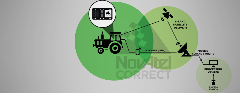
NovAtel Inc. announces that with the release of its 6.400 firmware, NovAtel CORRECT positioning technology is now available with TerraStar’s precise point positioning (PPP) corrections. Delivered via L-band, TerraStar corrections provide decimeter-level accuracy worldwide on all NovAtel OEM6 high-precision receivers, without users having to add base-station infrastructure. Subscriptions to the TerraStar correction service are available seamlessly to customers through NovAtel’s standard sales order process.
NovAtel CORRECT optimally combines data from multiple GNSS satellite constellations with corrections from a variety of sources, to deliver the best position solution possible. The strategic importance of TerraStar’s decimetre-level correction service to NovAtel’s product offering is reflected in the recent purchase of TerraStar parent company Veripos by Hexagon.
“The OEM nature of TerraStar’s correction service makes them a perfect partner for NovAtel,” stated Sara Masterson, New Business Development Manager for NovAtel. “We are extremely pleased with the performance of our current TerraStar offering and, with the ability to now work more closely together, we are very excited about developing positioning innovations for our customers in the future.”
NovAtel CORRECT is available for land, air and sea applications, providing customers with one-stop shopping for receivers, antennas and correction services. It provides integrators with the opportunity to choose pricing and subscription options that best match their OEM business objectives.
From a weather perspective, Aberdeen, Scotland, may not be the most inviting location in the world in which to live. Nevertheless, Aberdeen is the leading European oil & gas business hub and is one of eight “super cities” spearheading the UK’s economy. But it’s waaaaay up north of the border with England on the east coast of Scotland — winter conditions can be difficult, even inhospitable at times. But if you want to transmit differential corrections out to shipping and oil rigs in the North Sea, it’s an ideal location.
Since its first beginnings in Aberdeen, Veripos has evolved to become a major worldwide business for marine, and now also for “precise land navigation, positioning and guidance solutions.” Veripos is now delivering augmentation services on a global basis, employs more than 130 specialist personnel based in 11 sites around the world, and in 2013 had revenues of more than $45 million. With a global ground network of more than 80 dual-redundant receiver base stations, Veripos now provides not only traditional differential GNSS transmissions, but also precise GPS and GLONASS orbit and clock corrections over seven Inmarsat GEOs and also via the Internet — we now call Precise Point Positioning (PPP).
Veripos ground receiver station network.
Veripos began in March 1989 as a joint venture between Brown & Root Survey and Ormston Technology, a specialist marine electronics company based in Hull, England. Initially, Veripos provided a conventional Differential Global Positioning Service (DGPS) for users in the North Sea based on HF radio transmitters.
Introducing a much broader satellite-based DGPS service in 1994, coverage was extended to cover the Gulf of Mexico followed by further expansion of the network/coverage into Brazil, West Africa, Mediterranean and Caspian Sea. Veripos became a wholly-owned subsidiary of Subsea 7 in the same period. Following a major expansion in late 2004, full global service coverage was achieved in 2005, and ultimately Veripos became the second largest precise satellite positioning services supplier in the world to the marine industry, with leading clients in exploration, seismic, construction, survey, offshore supply vessels (OSV) and offshore drilling. In late October 2012, Veripos diversified further, launching its TerraStar business to address the land and near-shore sector.
Achieving global accuracies of 5-10 centimeters using relatively small amounts of data, users worldwide are mostly able to accommodate the initial convergence time needed to achieve these higher accuracies. Veripos claims that using multiple constellations, convergence time can be down to less than 10 minutes — even lower for hot starts.
The “free” IGS data that competes with Veripos and other subscription correction providers is also pretty good, but it’s not generally used by commercial operations.
IGS Multi-GNSS Experiment Tracking Network.
IGS data is provided by academic and government sources around the world, and the advantage is not only free access, but also open data and multiple open-source software tools and data, all built to published open standards. But the IGS system is not a 24/7 reliable data source, and support can be a problem. It’s not designed for companies who must have service guarantees in order for them to consistently operate profitably in difficult conditions — it’s more experimental, for research and testing for the academic and government outfits that produce the data, along with a whole bunch of engineering teams who take advantage of free data and can cope with system hiccups for their R&D and for comparison purposes.
So Veripos and other commercial providers overcome the weaknesses of IGS by providing a worldwide network that is well maintained — an infrastructure designed for high reliability and availability. Each base station has dual-redundant receiver and communications links. There are three processing centers, two active and one on warm standby, that can each operate the whole system, and each of the processing centers has dual-redundant equipment. There are seven geostationary satellites with a large degree of coverage overlap, and Internet data feeds also provide a backup. More than these system design features, Veripos works directly with its customers to ensure successful integration of their corrections with customer operations and, above all, supports the customer directly during these operations. If the customer is not operational, Veripos recognizes that down time means lost profits for its customers, so its staff work hard to avoid any service interruptions.
It’s not clear what would happen to this currently stable marketplace if and when Galileo begins selling a commercial service on E6, but the existing commercial service providers are pretty sure that competition in their segment from a government provider that is publicly funded is not in their best interests. At the recent Munich Satellite Navigation Summit, Gian-Gherardo Calini from the European GNSS Agency certainly received a clear message from Trimble, NovAtel, Veripos and Fugro (to a lesser extent) that these companies do not believe that Galileo should be entering their market. However, Calini did state several times that the GNSS agency did not want to disrupt this market. How to do that when the Galileo infrastructure, control systems and satellites are wholly government funded remains unclear. Even if the service were wholesaled to a commercial provider, it’s unlikely that the retailer would have to bear the full cost of maintenance and support of the entire Galileo ground and space infrastructure, so their service would in effect be hugely subsidized.
Veripos recognized that focusing on its marine service alone is ignoring the land segment. So the company established a new business called TerraStar to address the land segment, just as Fugro had spun off OminSTAR for the land segment many years ago. TerraStar is still a division of Veripos, and the PPP infrastructure and distribution system it uses is the same. TerraStar is focused entirely on land and close-to-shore operations, so its business development and marketing is aimed at wholesaling its services through OEMs for these segments, while Veripos continues in parallel solely with marine and offshore.
Initial OEMs to sign up were Septentrio and Altus, which is a subsidiary of Septentrio that focuses on survey products and applications. Septentrio had a number of successes with DEME dredging and land reclamation in Belgium and terrascan airborne geophysical survey in South Africa and Germany.
Terrascan airborne geophysical survey.DEME land reclamation.
And here we arrive at the place where these companies all start to come together. In mid-March this year, Hexagon acquired Veripos, along with TerraStar. Hexagon is, of course, the parent that has NovAtel and Leica in its thoroughbred stable of GNSS industry leaders. Could this acquisition have something to do with John Deere/NavCom operating its own StarFire PPP system, or Trimble acquiring OmniSTAR from Fugro and now providing its own range of PPP correction services?
Well, NovAtel rolled out NovAtel Correct and new software at the end of March for its OEM6 high-precision receivers, which includes TerraStar’s precise point positioning (PPP) corrections. And NovAtel now has a closely associated company within the Hexagon stable, so a long-term association between NovAtel and Veripos/TerraStar is just about assured. And, with a big company group like Hexagon and many potential connections between group members with common interests, the prospect for continued investment as revenues increase means Veripos should be even better positioned going forward.
And, of course, adding NovAtel customers, including other potential OEM third parties, to the Veripos/TerraStar user base all helps both companies’ revenue and keeps their parent Hexagon happy too. So actually, it’s all about increasing the bottom line!
The regulatory announcement explains that Hexagon, Topcon Europe B.V. and Topcon Corporation have entered into a memorandum of understanding (MoU) related to Veripos, Inc. Hexagon Acquisition Ltd., an indirectly wholly owned subsidiary of Hexagon, has made an unconditional cash offer for all outstanding shares in Veripos not already owned by Hexagon Acquisition Ltd. Hexagon Acquisition Ltd. owns and has received acceptances and pre-acceptances for a total of 9,980,630 shares, representing 30.1 per cent of the outstanding shares in Veripos.
Under the MoU, Hexagon would establish a customer agreement between Topcon and Veripos, under which Topcon will act as a reseller of the satellite broadcast correction signal offered by Veripos. This “TerraStar Agreement” between Veripos and Topcon is intended to be an agreement with TerraStar GNSS Ltd., a wholly-owned subsidiary of Veripos and the contractual partner for all resellers and customers of the on-shore services. Under the TerraStar Agreement, Topcon will be entitled to offer the signal to its customers and to make its products compatible with the signal.
Also under the MoU, Hexagon and Topcon will establish a separate joint venture company on an equal partner basis for the purposes of pursuing joint efforts and cooperation in relation to the future development and direction of the services provided under the TerraStar Agreement.
GNSS receiver manufacturers who are partners with TerraStar include NovAtel, Altus Positioning Systems, and Septentrio Satellite Navigation.
The acceptance period for the unconditional cash offer expires on January 29, subject to further extensions but not beyond February 7.