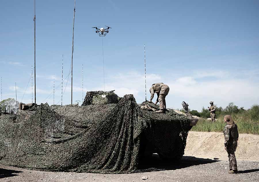
Elistair, manufacturer of tethered drones for security applications, participated in Orion 2026, France’s most ambitious joint military exercise in decades. In the exercise, Elistair contributed its Khronos automated tethered DroneBox, used for ISR and tactical communications missions.
Running from February to April, ORION 2026 mobilized up to 12,500 military personnel across the country in a high-intensity, multi-domain scenario involving land, sea, air, space, cyber and electromagnetic domains. More than 1,200 drones of all types were deployed throughout the exercise.
Elistair participated in Phase O4 (April 7–30) following its fisrt contribution during Phase O2 in February, which demonstrated France’s ability to fully integrate into a NATO command structure for collective defense scenario. During the week of April 27, forces conducted offensive exploitation operations, river crossings, retaking of key positions, and live-fire exercises.
The Khronos system
Forces need real-time situational awareness in contested and GNSS-denied environments. The Khronos system provides continuous aerial surveillance from fixed or mobile platforms. It does not depend on GNSS, radio frequency infrastructure, or battery-limited free-flying aircraft.
Khronos deploys from a transportable DroneBox in under two minutes. The system can deliver continuous day and night imagery for up to 24 hours, making it a “pocket watchtower” for tactical units.
The tethered drone operates in GPS- and RF-denied conditions through a secured tether and advanced positioning system. Elistair targets armed forces, law enforcement, civil security agencies, and private security operators in more than 70 countries. The company runs operations from France and North Carolina.
“Seen & Heard” is a monthly feature of GPS World magazine, traveling the world to capture interesting and unusual news stories involving the GNSS/PNT industry.
Tethered drone
Spanish police used a tethered drone system for traffic monitoring, crowd control and surveillance of the UEFA Champions League Final, played June 1 at the Wanda Metropolitano stadium in Madrid. An Elistair tethered U06 Plus drone oversaw 67,000 fans in the stadium and 200,000 in nearby streets. Use of the drone was in response to a heightened terrorist threat level in Spain, making it part of the largest security operation for any sporting event in the Spanish capital. Continuously supplied with power, the drone maintained its position at 50 meters high for 8 hours.
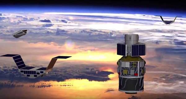
CYGNSS satellite launch. (Artist’s concept/NASA)
Tricky Signals
NASA’s eight CYGNSS (Cyclone Global Navigation Satellite System) microsatellites collect radio signals from GPS beacons to characterize hurricanes. A month after launch in December 2016, the CYGNSS team noticed the signals were wavering when the U.S. began to boost the radio power on 10 GPS satellites as they passed over northern Syria. The swings don’t interfere with other scientific uses of GPS, but for CYGNSS the measurements of high winds varied by 5 meters a second or more — the difference between a category-2 and category-3 hurricane. After two years of work, the CYGNSS team has compensated by repurposing a secondary antenna on the satellites to measure GPS signal strength.
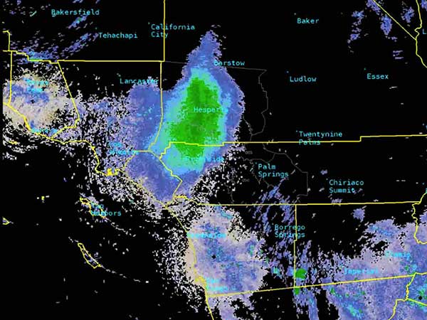
The ladybug blob tracked by Doppler radar. (Image: National Weather Service)
Ladybug, ladybug, fly away home
In this case, California. In June, a millions-strong swarm of ladybugs showed up on radar as a weather event when the insects took to the sky to hunt for aphids. One explanation for the unusual swarm is that a large population of ladybugs had been spread out in a mountainous area, and rising temperatures triggered their mass migration to valleys where they might find an abundance of aphids to eat.
New Zealand joins Aussies on SBAS
Land Information New Zealand (LINZ) will work with Australian counterpart Geoscience Australia to investigate ways to deliver a regional satellite-based augmentation system (SBAS) to significantly improve GPS accuracy. The proposed SBAS will support emergency helicopter crews, providing pilots with accurate vertical guidance for landing, enabling them to reach people faster in difficult terrain and bad weather. The SBAS will also improve the safety of self-driving cars. The new system will improve accuracy to less than a meter, and in some devices to 10 centimeters.
Tony Murfin Contributing Editor, Professional OEM & UAV, GPS World
As the days tick down towards the always-anticipated Association for Unmanned Vehicle Systems International (AUVSI) Xponential convention in Denver May 1-3, the unmanned vehicle industry is preparing once more for one of its largest exhibitions.
More than 750 exhibitors will be spread over a huge 370,000-square-foot exhibit floor at the Colorado Convention Center and 8,500 visitors from unmanned systems and robotics are expected to come to share ideas, gain insights and carefully examine the unmanned innovations on show.
STEM Outreach. This year the show will not only feature industry innovation and growth, but will also highlight resources for potential science, technology, engineering and math (STEM) graduates with interactive and engaging content, including:
A buildathon/hackathon to conceive, design and build inventions during a timed competition prior to Xponential. Final projects will be displayed on the Xponential show floor as a representation of innovation and collaboration.
A dedicated area in the Xponential exhibit hall will describe the STEM education programs and services supported by AUVSI and the AUVSI Foundation to foster and cultivate the next generation of innovators and leaders.
An area of the show floor will also showcase the winners of student robotics competitions.
Denver area high school students will be invited to tour the exhibit area to introduce them to emerging unmanned technologies and applications.
A reception at the show promises to mix young professionals in unmanned systems with seasoned industry leaders, and finally,
The Women and Diversity in Robotics forum will feature speed networking with leaders to review STEM opportunities for career-focused women and girls.
Survive and Thrive. Meanwhile, the Denver exhibition will demonstrate how the rapidly evolving world of UAVs has encouraged “survive and thrive” for those new entrants who together seem to have adapted to address almost any and all opportunities. We’ll mention a couple of examples here, and attempt to provide a better cross section of the huge number of companies and products present following the actual show.
For instance, one of the drawbacks for small, predominantly electric-powered, multi-rotor UAVs is that their endurance is limited. Providing longer duration operations may be outside their envelope — for such longer term things as providing temporary mobile-phone signal coverage, or police/agency reconnaissance/search, or for larger vertical inspection jobs.
Presumably, floating one of several available models of lighter-than-air, blimp-type UAVs might be more expensive or cumbersome than using a multi-rotor unmanned vehicle, so overcoming power-supply issues would seem to be key. One way to do this is to attach a strong tether bringing power up from the ground.
Orion UAS. The Elistair (France) Orion UAS will no doubt be featured on the company’s booth. This multi-rotor UAV has been developed for longer term aerial surveillance and telecommunications operations. Typical users include law enforcement, private and public safety, national security, asset protection, emergency communications and crisis management, so these tethered drones are deployed by police forces, public security departments, public and private security companies, and governments in more than 30 countries.
Photo: Elistair
The Orion UAS uses industrial components and system redundancy, including autopilot sensors, motors, power distribution and logic controls, and has an emergency parachute system. The patented micro-tether system ensures a stable platform supplied with continuous power from the ground to enable up to 10 hours of endurance. The mechanical structure of the drone is designed to sustain strong winds with maximum stability. With system redundancies and automated emergency procedures, the user is able to focus on safety-critical missions and data collection, while the risk of human mistakes is reduced.
The onboard camera has both FLIR and optical, enabling night/day surveillance with gimbal stabilization and low latency — the 30x optical zoom makes it possible to detect a moving person from kilometers away. And the tether system provides high-speed, interference-free data transmission so the system is also virtually undetectable. It’s easy to see why tethered drones are becoming more popular for security applications.
Identifying UAVs. At the FAA Unmanned Aircraft Systems (UAS) Symposium last week in Baltimore, a key issue discussed concerned remote identification and tracking of drones. It would seem that the FAA is about to announce a new rule that could eventually clear the way for drones flying over people and beyond line-of-sight of their operators — and this may be a key topic of discussion at Xponential.
The FAA rule appears to mandate that every drone should in some way communicate its identification — presumably its FAA registration ID — so that its operator could also be known.
One well-known company, Ford, has already announced that it has a concept using onboard collision lights on a drone to optically signal the 10-digit FAA registration number to the ground for capture and decoding. Maybe other exhibitors at the show will have other solutions — perhaps radio based? We’ll see.
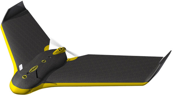
Sensefly eBee drone.
Sensefly’s eBee. At the sensefly booth, we may also hear about several interesting announcements on recent drone applications:
Products on display will include the RTK/PPK-enabled eBee Plus professional mapping drone, the eBee SQ drone for agricultural applications and the albris mapping and inspection drone, as well as the senseFly S.O.D.A camera and GeoBase.
In addition, senseFly sales manager and GIS scientist Briton Voorhees will deliver a presentation titled, “Comparing workflow and point cloud outputs of the Trimble SX10 TLS and senseFly eBee Plus drone,” on Wednesday, May 2, at 11 a.m. in the Mapping and Surveying Track.
Booth visitors can also find out more about senseFly’s comprehensive 360 solutions, which are designed to improve operational efficiencies and support decision-making in the surveying, mining and quarries, agriculture and inspection sectors.
And many more. GNSS players also expected to be at the show include Hemisphere GNSS, NovAtel, Rockwell-Collins, Septentrio, Tersus, Trimble, Accord/Aspen Avionics, Comnav, Navtech, Swift and Topcon, as well as GNSS chip manufacturers u-blox and Intel — although Intel may likely focus on its UAV/communications offerings at this show.
There will also be a number of antenna suppliers, inertial sensor manufacturers, UAV autopilot manufacturers and several ancillary electronics and mechanical systems suppliers — all trying to solidify their positions in the UAV vehicle and systems integration supply chain.
The major focus, as usual, will be on UAV/UAS vehicle manufacturers and system integrators and their products — there is always a great exhibition of actual UAVs from all sectors of the industry.
So, along with a parallel program of educational presentations on a wide range of industry aspects, the AUVSI Xponential convention promises to have plenty of opportunities to find things of interest to almost anyone, and many areas to focus on for experts already in the industry.