Testing on Galileo’s second-generation hardware has begun.
Test versions of the satellites’ navigation payloads is undergoing evaluation by Airbus Defence and Space at its Ottobrunn facility in Germany and by Thales Alenia Space at the ESTEC technical center in the Netherlands of the European Space Agency (ESA).
Known as the Galileo Payload Testbeds (GPLTBs), these are development models of the navigation payloads intended for the Galileo Second Generation (G2) satellites. The navigation antennas of the testbed payloads are being testing to check whether they meet the ambitious performance levels set for the G2 satellites.
Instead of being assembled from space-ready components like an actual satellite payload, the GPLTBs are built from electronic parts placed in test racks, with a proof-of-concept version of a navigation antenna attached.
“The goal with these test campaigns is to prove their design concepts early, and anticipate any technical issues that might arise as early as possible,” said Cédric Magueur, ESA’s payload manager for the Thales G2 satellites.
“These campaigns also make it possible to develop and validate new performance measurements concepts for these new generation of complex navigation payloads,” said Dirk Hannes, ESA’s payload manager for the Airbus G2 satellites. “This will allow us to optimize the production efficiency of the flight model series.”
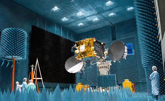
The second satellite in the European Data Relay System (EDRS) undergoes tests at Airbus’s Compact Antenna Test Range facility. (Photo: ESA)
“Results from the testing will feed into the up-coming Preliminary Design Review for the new satellites, backing up the analyses by the companies with solid measurements,” Cédric said. “Such early testing also supports the ambitious timescale for the development and construction of G2 satellites, with the first satellites planned to reach orbit by the middle of this decade.”
There are 26 Galileo satellites now in orbit; deployment of 12 more will begin by the end of this year. Next will come the first 12 G2 satellites, featuring enhanced navigation signals and fully digital payloads. The new generation will be made up of two independent families of satellites meeting the same performance requirements, produced by Thales Alenia Space in Italy and Airbus Defence and Space in Germany.
Airbus Defence and Space’s GPLTB is undergoing radiated testing at the company’s Ottobrunn facility, inside a Compact Antenna Test Range (CATR). Meanwhile, the Thales Alenia Space GPLTB is about to start testing inside ESTEC’s own Hybrid European Radio Frequency and Antenna Test Zone (Hertz) chamber. The metal-walled chambers are isolated from external radio interference, with inner walls studded with foam pyramids to minimize radio-frequency signal reflections, mimicking the void of space.
“Up until now all GPLTB testing has taken place by plugging them into test boards,” Cédric said. “These test campaigns mark the first time that their performances will be confirmed in terms of radiating signals. In our first phase we will perform near-field measurements directly around the antenna to measure all the characteristics of the signal shape, to check it matches previous conductance tests. Then, via computation, we can derive its far-field performance.”
In the second test phase, the actual far-field measurements will be performed using another feature of the chambers, a pair of paraboloid reflectors. In this way, the signal from the testbed can be reshaped as if it had traveled the long distance that actual Galileo signals need to travel, from an altitude of 23,222 km down to Earth’s surface.
At Airbus, the testing is being undertaken in reverse order, with the far-field measurements taking place before performing the near-field measurements.
A team of companies and government agencies is developing satellite services provided by ASECNA’s A-SBAS (Satellite-Based Augmentation System) for Africa and the Indian Ocean. Besides the current SBAS, the joint venture will deliver precise point positioning (PPP, through CNES and Geoflex) and danger warnings for a wide range of applications in Africa.
Working together are the Agency for Air Navigation Safety in Africa and Madagascar (ASECNA), Nigerian Communications Satellite Ltd. (NIGCOMSAT) and Thales Alenia Space, the joint venture between Thales (67%) and Leonardo (33%). The project is backed by Geoflex, a provider of cloud services that deliver improvements to GPS/GNSS applications to achieve positioning accuracy to within 4 centimeters on land, at sea and in the air.
The new SBAS services are expected to aid agriculture and other sectors in Africa. Here,volcanic cinder cones and farming in rich volcanic soils on the border of the Democratic Republic of Congo and Rwanda. (Photo: iStock/Getty Images Plus)
Demonstrations
The three partners successfully demonstrated the additional services on July 7 and 8 in Brazzaville, Congo, by calling on the SBAS signal they have broadcast over the Africa and Indian Ocean (AFI) region since September 2020 to provide the first SBAS open service in this part of the world via the NigComSat-1R satellite. This trial follows successful flight demonstrations this year in Lomé in January and Douala in June.
The first demonstration of the special urgent situation warning service via satellite showed the system’s ability to broadcast a warning message via the A-SBAS signal to mobile phones, without requiring a terrestrial network. This service sends a message to the populations concerned, providing information on the type of danger and instructions to be followed.
The second demonstration entailed the transmission of GNSS corrections based on CNES/Geoflex PPP technology and also using the A-SBAS signal. This approach showed the system’s ability to achieve positioning accuracy to within centimeters across the entire African continent.
The new satellite service paves the way for applications in a broad range of sectors, including precision agriculture, land and maritime transport, rail safety, drone navigation, mapping and surveying. The ASECNA SBAS was developed as part of the ‘’SBAS for Africa & Indian Ocean’’ programme as a first step towards providing robust navigation services in the aviation sector.
ASECNA’s 18 Member States are Benin, Burkina Faso, Cameroon, Central African Republic, Comoros, Congo, Côte d’Ivoire, France, Gabon, Guinea Bissau, Equatorial Guinea, Madagascar, Mali, Mauritania, Niger, Senegal, Chad and Togo.
Thales Alenia Space, a joint venture between Thales (67%) and Leonardo (33%), has been selected by the European Commission for a new strategic contract to assess the feasibility of an integrity service to complement the European Global Navigation Satellite System (EGNSS) High Accuracy service, which will pave the way for use in autonomous vehicles.
Thales Alenia Space will focus on the development of a sensor-fusion approach, including and complementing evolutions of EGNSS High Accuracy. These service evolutions are aimed at providing the integrity level to serve the high-reliability and high-accuracy positioning needs of new, demanding applications such as autonomous vehicles on the road and autonomous transport in the maritime and rail sectors.
With this contract, Thales Alenia Space will assess the extension of the integrity and safety-of-life services for aviation into the road, rail and maritime sectors. In 2020, the company won the EPICURE project, based on an integrity concept for road travel (tolls and insurance), as well as the IMPRESS project, targeting an integrity service for rail signaling and train separation.
Thales Alenia Space has been a prime contractor for EGNOS (European Geostationary Navigation Overlay Service) for 25 years. It is a lead industrial contributor to the Galileo system and its ground mission segment and responsible for providing six Galileo Second Generation satellites. In April, the company was awarded a contract to support the implementation and experimentation of the navigation algorithms that will be used in the Galileo Second Generation program.
Project will boost the positioning performance and real-time operability of the Galileo system.
The European Space Agency (ESA) has selected Thales Alenia Space to support the implementation and experimentation of the navigation algorithms that will be used in the Galileo Second Generation program. Under the contract, Thales will develop the Advanced Orbit Determination and Time Synchronisation (ODTS) Algorithms Test Platform (A-OATP).
Thales Alenia Space, a joint venture between Thales (67%) and Leonardo (33%), is the prime contractor for Galileo First Generation’s Ground Mission Segment,.
ESA granted the contract on behalf of the European Commission in the Horizon 2020 Satellite Navigation Program (HSNAV).
In a previous contract, Thales Alenia Space was chosen to provide six satellites and initiate the B2 phase of development and implementation of its ground segment for the Galileo Second Generation constellation.
Using its long-standing legacy regarding navigation algorithms in addition to an innovative approach, Thales Alenia Space will develop and test a new Advanced ODTS solution. The new orbitography algorithms will allow a significant improvement in positioning performance and real-time operability of the Galileo system. It will exploit the accuracy of the GNSS orbit and clock estimation, with a solution optimized for the real-time generation of Galileo navigation messages, and take full advantage of the evolution of satellites and ground stations considered in the Galileo Second Generation.
With this new contract, Thales Alenia Space applies on a deep experience concerning orbitography algorithms as well as knowledge of the Galileo system to strengthen its position as a major actor for the development of the new generation of this satellite system, the company stated in a press release.
The European Commission has issued industrial contracts worth €1.47 billion ($1.97 billion) to build next-generation Galileo satellites to Airbus and Thales Alenia Space, reports BBC News.
Both companies told BBC News that they will not speak publicly about their contracts wins until documents are signed, which could take several weeks.
Each contract is for manufacture of six satellites, to orbit no earlier than 2024. They will feature digitally configurable antennas, inter-satellite links, new atomic clocks and propulsion systems that use electric engines.
Airbus and TAS built the four Pathfinder in-orbit validation satellites that first demonstrated Galileo. A consortium of OHB-System and Surrey Satellite Technology Ltd. built the first operational Galileo satellites, but the consortium ended following Brexit.
Service opens a new era of satellite navigation performance augmentation in the Africa and Indian Ocean Region
The Agency for Air Navigation Safety in Africa and Madagascar (ASECNA) has started to broadcast a satellite-based augmentation system (SBAS) signal over Africa and the Indian Ocean (AFI) region.
This is the first SBAS open service in this part of the world, according to Thales Alenia Space. The signal is broadcast via the NIGCOMSAT-1R satellite managed and operated by Nigerian Communications Satellite Ltd. under the Federal Ministry of Communications and Digital Economy of Nigeria.
The early open service is provided as part of the “SBAS for Africa & Indian Ocean” program, which pursues the autonomous provision over the continent of SBAS services to augment the performances of the satellite navigation constellations GPS and Galileo.
With improved accuracy to within a meter — and boosted integrity, availability and continuity of safety-related applications — the SBAS services will improve flight safety and efficiency in Africa. It will also benefit the economy in land, sea and rail transport areas, as well as mass-market applications, supporting user safety, cost-effectiveness and sustainable development.
Early Service Goals
The launched open service aims to carry-out technical trials, and to undertake with partner airlines field demonstrations for aircraft to demonstrate the benefits of the future operational safety-of-life SBAS services, expected in 2024. It will also include early precise point positioning (PPP) and emergency warning service, both to be demonstrated.
The signal in space is generated by a dedicated system testbed, developed as part of the “SBAS for Africa and Indian Ocean” preliminary design phase, financed by the European Union and awarded to a Thales Alenia Space joint venture between Thales (67%) and Leonardo (33%). The system prototype uses the SAGAIE reference station network deployed by CNES and ASECNA with the support of Thales Alenia Space.
The signal is broadcast via the SBAS payload on Nigcomsat-1R GEO satellite of the Nigerian Communications Satellite and an uplink station deployed in Abuja (Nigeria). It is compliant to the Standards and Recommended Practices of the International Civil Aviation Organisation, and the Minimum Operational Performance Standard developed by the RTCA (Radio Technical Commission for Aeronautics) organization. It will be visible in the whole Africa and Indian Ocean, up to the West Australian coast, and also in Europe.
“We are proud to be part of this ambitious program to provide satellite navigation services in the Africa and Indian Ocean region. The use of our geostationary communication satellite Nigcomsat-1R navigation payload to broadcast the first signal will be Africa’s premier contribution to SBAS as a regional satellite-based augmentation system for the continent,” said Abimbola Alale, MD/CEO of NIGCOMSAT Ltd.
“Our long-standing expertise acquired with the development of EGNOS SBAS in Europe and KASS SBAS in Korea combined with our new leading-edge satellite positioning technologies makes Thales Alenia Space the ideal partner to best support countries to implement their own SBAS efficiently. The equatorial region represents also a key engineering challenge for such a system due to difficult ionosphere conditions, for which Thales Alenia Space has developed a proven solution,” said Benoit Broudy, vice president of the Navigation business at Thales Alenia Space in France.
“The provision of the first African SBAS early service is a crucial major step forward in the development of satellite navigation in the AFI Region, and in the deployment of the ‘SBAS for Africa and Indian Ocean’ system, the navigation solution for Africa by Africa. It demonstrates the ambition and commitment of ASECNA to enhance air navigation safety for the benefit of the whole continent, in line with my vision for the unification of the African Sky,” stated Mohamed Moussa, director general of ASECNA.
About ASECNA
ASECNA is an international public organization. Its main mission is to provide air navigation services within an airspace of 16,500,000 square kilometers, divided into six flight information regions (F.I.R) as defined by the International Civil Aviation Organization (ICAO).
ASECNA also develops solutions for airport management, aviation infrastructure studies and construction, equipment maintenance, calibration of air navigation instruments and training for civil aviation staff.
Its 18 Member States are: Benin, Burkina Faso, Cameroon, Central African Republic, Comoros, Congo, Côte d’Ivoire, France, Gabon, Guinea Bissau, Equatorial Guinea, Madagascar, Mali, Mauritania, Niger, Senegal, Chad and Togo.
With 26 satellites now in orbit and more than 1.5 billion smartphones and devices worldwide receiving highly accurate navigation signals, Europe’s Galileo navigation system will soon become even better, ensuring quality services over the next decades.
Following the European Commission’s decision to accelerate development of Galileo Next Generation, ESA has asked European satellite manufacturers to submit bids for the first batch of the Galileo Second Generation (G2) satellites. The new spacecraft are expected to be launched in about four years.
Paul Verhoef, director of the Galileo Programme. (Photo: ESA)
The next-generation satellites will provide all the services and capabilities of the current first generation with a substantial improvements and new services and capabilities.
“We want an ultra-flexible and mostly digital design,” said Paul Verhoef, ESA director of Navigation.
“Developing the second generation is challenging for both industry and for ESA. In 2024, we need to launch the first satellites for this new state-of-the-art constellation.”
Invitation to Tender
Following almost 24 months of a competitive dialogue procedure with the three large system integrators involved, ESA issued a “Best and Final Offer” invitation to tender on Aug. 11 to Airbus, OHB System AG and Thales Alenia Space.
ESA is implementing a dual-sourcing approach, and two parallel contracts are expected to be signed by the end of 2020 among the current three bidders. Under the plan, each of the two selectees will build two satellites for development purposes, with options for up to 12 satellites in total.
The first satellites of the new constellation are expected to be launched before the end of 2024, together with updated ground systems to support the new satellites.
Reconfigurable in Orbit
In addition to being more powerful, the second-generation Galileo satellites will be more flexible, able to be reconfigured in orbit in order to satisfy the expected evolution in end-user needs.
A number of challenges exist for the bidders. The goal of a digital and fully flexible design represents the cutting edge of industrial capability.
Navigation Antenna Progress
A Galileo satellite undergoes its fit-check validation at the Kourou Spaceport in French Guiana. (Photo: ESA/Arianespace)
Furthermore, the required navigation antennas will have a very advanced design; much research and development by ESA has been done, yet more remains for industry.
ESA has already built such an antenna as a proof of concept at the Agency’s ESTEC technology center in the Netherlands to ensure feasibility, and the know-how has been shared with the three bidders.
“Each bidder must determine how they can best manufacture the navigation antenna, and we’ll have to see how each proposes to do it. Also, requiring a fully flexible payload is quite a challenge. No such navigation spacecraft of that type have flown yet,” Verhoef said.
Ambitious Plan
The European Commission has decided that what was previously going to be called the “transition batch” of new satellites will now become, in fact, the Galileo Second Generation satellites. The European Commission and EU Member States have already made clear that they want to be very ambitious and further increase the technical capabilities of the Galileo system.
The name change reflects of how the current batch is actually shaping up.
The transition satellites were initially foreseen as interim upgrades, to cater for the potential risk of late delivery of the later, completely new and very advanced G2 satellites.
Estimated Lifetime Increased
Based on constant measurements of the performance of the current satellites in orbit, their predicted lifetime has increased. So, together with a slight spreading out of the launches of the Batch 3 satellites — currently under construction by OHB and in testing at ESTEC —this will ensure service continuity before the new, advanced capabilities of Galileo become operational.
The second-generation satellites will gradually take over from the current first-generation satellites in the provision of Galileo services. At a future date, they will all constitute a complete constellation plus the necessary in-orbit spares.
ESA serves as the design, development and procurement agent for Galileo satellites on behalf of the European Commission, which funds the system overall.
Thales Alenia Space has been awarded a grant under the European GNSS Agency’s (GSA) Fundamental Elements funding mechanism for the development of the GIANO (Galileo-based TIming Receiver for CriticAl INfrastructure Robustness) receiver, which aims to make critical infrastructure more robust against interference, jamming and spoofing.
In an increasingly complex GNSS environment in which there is both unintentional and deliberate disruption of satellite signals, the GSA is funding the development of a timing receiver for professional applications to address the needs of the critical infrastructure user community, mainly energy generation and distribution, telecommunications and financial operators.
Improved resilience
The GIANO receiver will leverage Galileo and EGNOS-driven innovation to improve the resilience of the receiver against interference, jamming and spoofing and increase the accuracy and reliability of the time transfer service. The timing platform prototype to be developed and validated will integrate all the latest innovative technologies, including professional products from Thales Alenia Space, paving the way for future Galileo-based timing receivers that offer improved resilience and accuracy at a reasonable cost.
“Critical infrastructure operators use GNSS for timing and synchronisation and are an important target segment for GSA Market Development because Galileo can make a difference. By funding the development of the GIANO receiver, the GSA aims to provide technological solutions to this community for robust and reliable timing,” said GSA head of market development Fiammetta Diani.
Toward this goal, outreach activities have been conducted among potential final users in the main commercial target groups to collect and analyse their needs. Then, following the definition and consolidation of stakeholders’ needs and the platform specifications, the project conducted a preliminary design review at the end of November 2019.
Europe-wide cooperation
The two-year project, funded under a GSA grant related to the Development of a Galileo-based timing receiver for critical infrastructures (GSA/GRANT/05/2017), will be coordinated by Thales Alenia Space in Italy, in collaboration with four European partners: Business Integration Partners S.p.A (BIP, Italy), PIKTime Systems (Poland), Space Research Centre of the Polish Academy of Science (SRC PAS, Poland) and DEIMOS (Portugal).
The project will also benefit from the support of the European Commission’s in-house science service – the Joint Research Centre (JRC) and the Italian National Metrology Institute (INRIM), which will make available its test facilities for verification activities on the developed equipment.
The European Space Agency (ESA) has received approval from the Galileo Security Accreditation Board to upgrade the global infrastructure running Europe’s Galileo satellite navigation system.
According to ESA, the resulting migration, set to start in February 2019, will incorporate new elements into the world-spanning system and boost the robustness of Galileo services delivered from the 26 satellites in orbit.
The system qualification campaign, which was run by the ESA Galileo project team in coordination with the WP1x system support team led by Thales Alenia Space in Italy, took more than a year to execute. It included more than 150 system tests — summing up to a total of 409 tests runs across Europe — in the various Galileo operational centers.
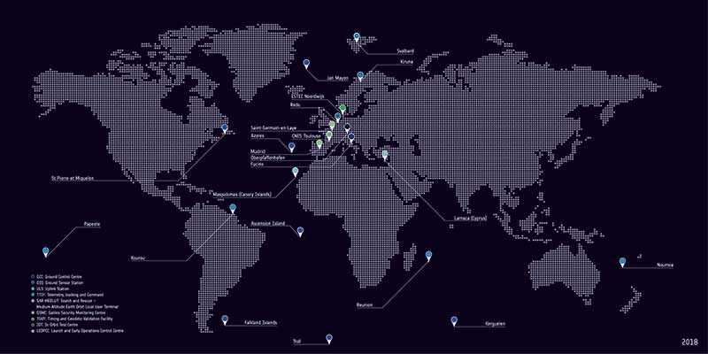
Galileo’s global ground segment. (Photo: ESA)
According to ESA, a major driver of this latest update was the growth of the Galileo constellation, which increased by 12 satellites through a trio of Ariane 5 launches in the last three years to become Europe’s largest.
The updated ground system incorporates a sixth telemetry, tracking and control station in Papeete, used to oversee Galileo satellite platforms, as well as an expansion of the number of antennas at the sites of uplink stations at Kourou in French Guiana, Reunion Island in the Indian Ocean and Noumea in French Polynesia.
In addition, receivers have been added to the Galileo sensor stations to ensure full redundancy.
“This marks the first update for Galileo’s operational infrastructure since it entered service,” said Edward Breeuwer, ESA Galileo system test and verification manager. “Galileo Initial Services began in December 2016, then last year we passed control of the system to our partner organization, the European Global Navigation Satellite System Agency, or GSA.
“This, therefore, marks a major step, but migration to the upgraded system should in principle be entirely transparent to Galileo users. We achieve this by taking advantage of the redundant elements of the Galileo system, taking them offline to update them while their operational counterparts continue to run.”
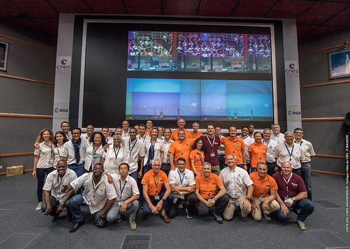
Countdown team at Kourou, Guiana control center for July’s four-satellite launch. (Photo: ESA/CNES/Arianespace, P. Baudon)
By Javier Benedicto Head, Galileo Programme department, European Space Agency
Since the declaration of initial services in December 2016, the European Space Agency (ESA) and the European GNSS Agency (GSA) have expanded Galileo’s system capabilities and service robustness with significant improvements of the ground segment and the last batch of four satellites launched by Ariane 5 in July. Once these satellites reach their final position and complete their in-orbit commissioning before the end of 2018, all 24 nominal slots of the Galileo constellation will be occupied.
Up to 22 satellites are planned to be commissioned in early 2019 and, eventually, the two FOC satellites injected in elliptical orbit should join the operational constellation after on-board software upgrade to provide for automatic health status flagging to users. This should lead to a total of 24 operational Galileo satellites supporting global PNT for users worldwide.
New Infrastructure Contracts
To further expand the system capabilities by 2020 and beyond, and reach Full Operational Capability (FOC), ESA has awarded new large industrial contracts in the context of the Exploitation Phase.
A contract to build and test another twelve Galileo satellites (so-called Batch-3) was awarded in 2017 to a consortium led by prime contractor OHB GmbH in Germany, with Surrey Satellite Technology Ltd in the UK as payload prime. These new satellites are based on the already qualified design of the previous Galileo FOC satellites. Production is advancing well, with first launch planned by late 2020.
With the Galileo constellation now expanded to 26 navigation satellites and plans to deploy additional Batch 3 satellites, the ground control infrastructure is undergoing a corresponding upgrades. In July, ESA awarded a new contract for the Galileo Ground Control Segment to GMV Aerospace and Defence, Spain. This contract includes upgrading the system architecture to manage a constellation of up to 41 Galileo satellites, updating obsolescent elements in the current system, improving operability linked to the provision of services and additional telemetry, tracking, and command capabilities to improve system robustness.
In October, Thales Alenia Space in France received a contract to upgrade the Galileo Ground Mission Segment and the Galileo Security Monitoring Centres (GSMC). This work includes upgrading Galileo’s system architecture to provide more accurate navigation products for broadcast by Galileo satellites, updating obsolescent elements in the current system and improving operability linked to the provision of services and enhanced robustness.
It will also include the construction of additional navigation message uplink and sensor stations. This contract will also augment the capabilities for implementation of the Public Regulated Service (PRS), the single most accurate and secure class of Galileo signals. Encrypted PRS signals will be made available only to authorized governmental users through approved national authorities. GSMCs in France and Spain will ensure the security monitoring functions for Galileo operational assets and manage PRS access and operations.
Growing Service Portfolio
The European Commission, GSA and ESA have jointly defined a broad range of service improvements and system capability enhancements to be deployed in 2019–2020, leading to FOC.
The newly qualified system infrastructure will support the broadcast of authentication information as part of the Open Service Navigation Message in E1; experimentation will start by end of 2019, leading to the possibility to offer trusted PNT to Galileo users.
Galileo will also be the first GNSS constellation to provide a Search and Rescue return link capability: as of 2019 the system will allow broadcast of acknowledgement of receipt message to users in distress with a very low latency, contributing to saving lives.
ESA has also started preparing the necessary modifications to the Navigation Signal Generation on-board the satellites to offer further capabilities to users after 2020. The signal-in-space will be enhanced with additional data transmitted in the I/NAV message, offering faster acquisition and more robust Galileo positioning on E1 and an encrypted navigation signal on E6 supporting authentication at signal level.
The new Galileo High Accuracy Service, soon entering the experimental phase, will consist in the delivery of un-encrypted high accuracy correction data in E6, enabling users to achieve sub-meter level positioning.
The usage of Galileo Open Service for aviation applications using horizontal advanced receiver-autonomous integrity monitoring techniques is being carefully assessed through measurements and review of the system design, including feared-events characterisation.
Longer Term Evolution
Galileo Second Generation has been the subject of technology pre-developments in the areas of platform and payload critical equipment, system techniques and processing algorithms, as well as system and segment Phase B studies over the past few years. We are now approaching the start of the implementation phase.
The European Commission, in close consultation with EU member states, has defined a decision roadmap aiming at very important future budget and programme implementation decisions in the course of 2019. In this context, ESA has launched a competitive procurement procedure for the first batch of so-called “Transition Satellites” with a broad range of enhanced and some new capabilities being considered. This includes improvements in the signal domain for faster acquisition and lower receiver power consumption, on-board clock technology, inter-satellite links, electrical propulsion, flexible payloads and power allocation by means of on-board digital technology and in-orbit re-configurability.
Transition satellites and related ground segment development contracts will begin by the end of 2019, aiming at in-orbit validation of second-generation capabilities from 2025 onwards.
EGNOS Evolution for Aviation
The adoption of Europe’s SBAS EGNOS by aviation is growing faster and faster. EGNOS will continue to evolve in the coming years. In particular, for 2019 and 2020, the evolutions under implementation focus on the obsolescence management of the hardware of some critical components, improvement of the system performances thanks to addition of new stations and system algorithms.
All these evolutions are planned to be qualified in 2021-2022, to continue to offer an excellent level of performance to Aviation Users until the operational take-over by the second generation of EGNOS V3,planned in 2025.
The European Performance-Based Navigation Implementing Regulation plans a growth from the current 35% to 66% in 2020 and 100% in 2024 of all European airports instrumental runways end-equipped with SBAS localizer performance with vertical guidance procedure.
On the aircraft manufacturer side, Airbus confirmed that it will continue equipping its aircraft; following the A350 family already equipped, both A320 and A330 families will be equipped for entry into service in summer 2020.
NAVISP
ESA’s Navigation Innovation and Support Programme (NAVISP), launched in 2017, will continue to boost member states’ industrial competitiveness and innovation in the upstream and downstream navigation sector, investigate the integration of satellite navigation with non-space technologies and complementary positioning and communication techniques, and study novel receiver-based techniques to counteract vulnerabilities and improve the robustness and reliability of GNSS.
Conclusion
The EU-built GNSS infrastructure systems EGNOS and Galileo are operational and serving users in Europe and worldwide. EC, GSA, ESA and European industries are committed to improvement plans over the next 2–3 years, with emphasis on endurance, resilience and robustness of the systems’ infrastructure, and delivering enhanced services.
For the longer term, the real challenge is to modernize the systems with new spaceborne and ground technologies, increase operational robustness and automation, and provide for additional system capabilities, while retaining a large degree of flexibility and in-orbit re-configurability to meet the long-term challenges and evolution of satellite-based navigation and timing.
The European Commission (EC) has awarded Thales Alenia Space a contract to develop and build an operational ground station on La Reunion Island to track GNSS satellites in medium Earth orbit. The ground station will be an operational part of the Galileo search-and-rescue (SAR) system.
The contract includes one Medium Orbit Local User Terminal (MEOLUT), engineering support and maintenance services for one year, and the hosting site on La Reunion Island.
Using Thales Alenia Space’s powerful and compact MEOLUT Next phased-array solution, the EC and European GNSS Agency (GSA) will improve their contribution to the Cospas-Sarsat system.
Thales Alenia Space is a joint venture between Thales (67 percent) and Leonardo (33 percent).
The ground station will receive and process 406-MHz distress beacon signals from the MEO satellites being tracked, and relay them to the SAR/Galileo network via the French Mission Control Center (FMCC) at the CNES facility in Toulouse. The contract also included the procurement of the best possible hosting site for this ground station.
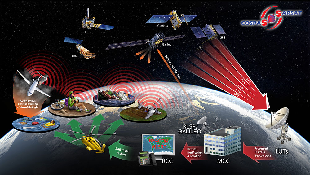
Image: International Cospas-Sarsat Programme
This MEOLUT Next will enhance the EC’s contribution to the Cospas-Sarsat SAR system by extending its coverage in the South Indian ocean, contributing to worldwide coverage. It complements the three MEOLUTs that are already deployed around Europe — in Larnaca (Cyprus), Maspalomas (Grand Canaria) and Spitzbergen (Norway) — and under responsibility of the GSA.
The MEO system, which replaces the legacy LEO (low Earth orbit) system, is designed to offer a faster response and better location data in near real time for search-and-rescue authorities, using spacecraft and ground facilities to detect and locate signals from the 406-MHz distress beacons.
The MEOLUT Next will also support the second generation of Cospas-Sarsat beacons. The SAR/Galileo site on La Reunion will be fitted with reference and calibration beacons to monitor the performance of the extended SAR ground segment and precisely calibrate MEOLUT measurements.
“Using Thales Alenia Space’s powerful and compact MEOLUT Next phased array solution, the European Commission will benefit from the world’s first spaceborne search & rescue system of this type,” said Philippe Blatt, vice president, Navigation France at Thales Alenia Space. “We are very proud that our advanced technology is now recognized by many customers worldwide. The performance logged by our MEOLUT Next units in service far exceeds requirements, which not only benefits our customer countries, but also makes travel even safer. It’s worth remembering that the Cospas-Sarsat system, operational since 1988, saves some 1,500 lives a year.”
Thales Alenia Space designs, operates and delivers satellite-based systems for governments and institutions, helping them position and connect anyone or anything, everywhere. Since commissioning in 2016, MEOLUT Next has delivered unrivaled performance, detecting distress signals from more than 5,000 kilometers away. Several countries have already chosen or are interested in the technology, including Canada and Togo.
If you’ve taken a flight in Europe recently, then the chances are growing that you’ve been a pioneer EGNOS user. Satellites in orbit would have guided your airliner’s descent, rather than signals beamed from the ground. You wouldn’t have felt any difference — except for possibly a smoother ride.
Cockpit of a new EGNOS-equipped Airbus 350 XWB, on show during the inaugural EGNOS Day at Toulouse-Blagnac Airport on May 7, 2015. (Photo: ESA)
More than 180 European airports have now been certified to make use of the ESA-designed European Geostationary Navigation Overlay Service — EGNOS — for approaches to given runways. This includes approaches at major hubs such as Paris Charles de Gaulle, Frankfurt and Amsterdam Schiphol. Thanks to EGNOS, safe landings would still be possible even if an airport were shut down entirely.
Sharpening the precision of GPS satnav signals over most European territory, EGNOS was designed to make satnav reliable enough for safety-critical aviation employment, but has found a wide range of other uses, from agriculture to road, rail and maritime transport.
An EGNOS app is available from the Apple and Google Play stores, offering easy access to all EGNOS-related information, including the different EGNOS services, official documentation, historical and current performance data, support material and contact with the 24/7 EGNOS helpdesk.
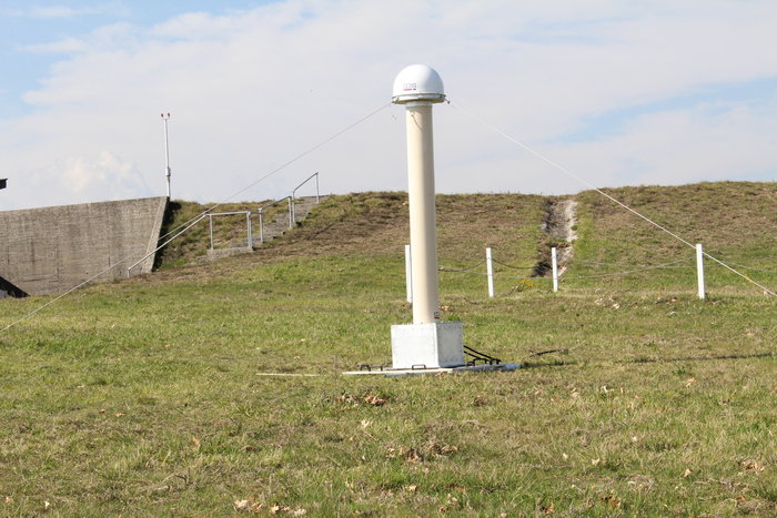
An EGNOS V3 Ranging and Integrity Monitoring Station (RAIMS) being tested at the Santiago de Compostella site in Spain, designed and manufactured by Thales Alenia Space in Italy. (Photo: ESA)
EGNOS is based on a network of monitoring stations across Europe that perform independent measurements of GPS signals, so that corrections can be calculated to boost satnav positioning performance. These results are passed to users immediately via a trio of geostationary satellites.
The service is allowed just a one in 10 million chance of error. If this tolerance is exceeded, EGNOS users are informed within six seconds. The result is that EGNOS-augmented signals meet the extremely high performance standards set out by the International Civil Aviation Authority, adapted for Europe by Eurocontrol, the European Organisation for the Safety of Air Navigation.
EGNOS operations are the responsibility of the European Global Navigation Satellite System Agency (GSA) of the European Commission and run by the ESSP, European Satellite Services Provider.
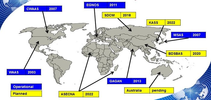
EGNOS is the European equivalent of the U.S. Wide Area Augmentation System (WAAS), which was the world’s first satellite-based augmentation system. The U.S. and European systems have been carefully designed to work together seamlessly.
Additional equivalent regional systems, fully interoperable with the existing ones are either in operation (Japan, India, Canada) or in definition or development (Russia, China, South Korea, West Africa and Australia).
Satellite-based augmentation systems worldwide. (Image: ESA)
Through the LPV-200 procedure, short for “localizer performance with vertical guidance 200 feet,” signals from space guide pilots through any weather down to within just 60 meters (200 feet) of the runway, at which point they make visual contact with the ground for a final go/no go landing decision.
EGNOS offers all-weather access to all certified runway approaches — each side of a runway requiring its own, separate, certification — without the need for expensive ground Instrument Landing System infrastructure. Satellite-based landing approaches can also be tailored to be smoother and more fuel-efficient.
Smaller airports unable to afford ground instrumentation draw the greatest benefit. Employing EGNOS means they get to operate in all weather conditions.
ESA retains the lead role in the future development of EGNOS, working with Thales Alenia Space and Airbus Defence and Space and their subcontractors to design, develop, deploy, and validate and test the new design elements.
While the current system is solely reliant on GPS, the next-generation EGNOS V3 will combine the use of GPS with Europe’s own Galileo satnav system to boost EGNOS accuracy and reliability still further. It is planned to enter service around 2025.