Tag: The Ohio State University

  • HSRP’s fall 2024 meeting highlights the progress of NGS geospatial grants

    HSRP’s fall 2024 meeting highlights the progress of NGS geospatial grants

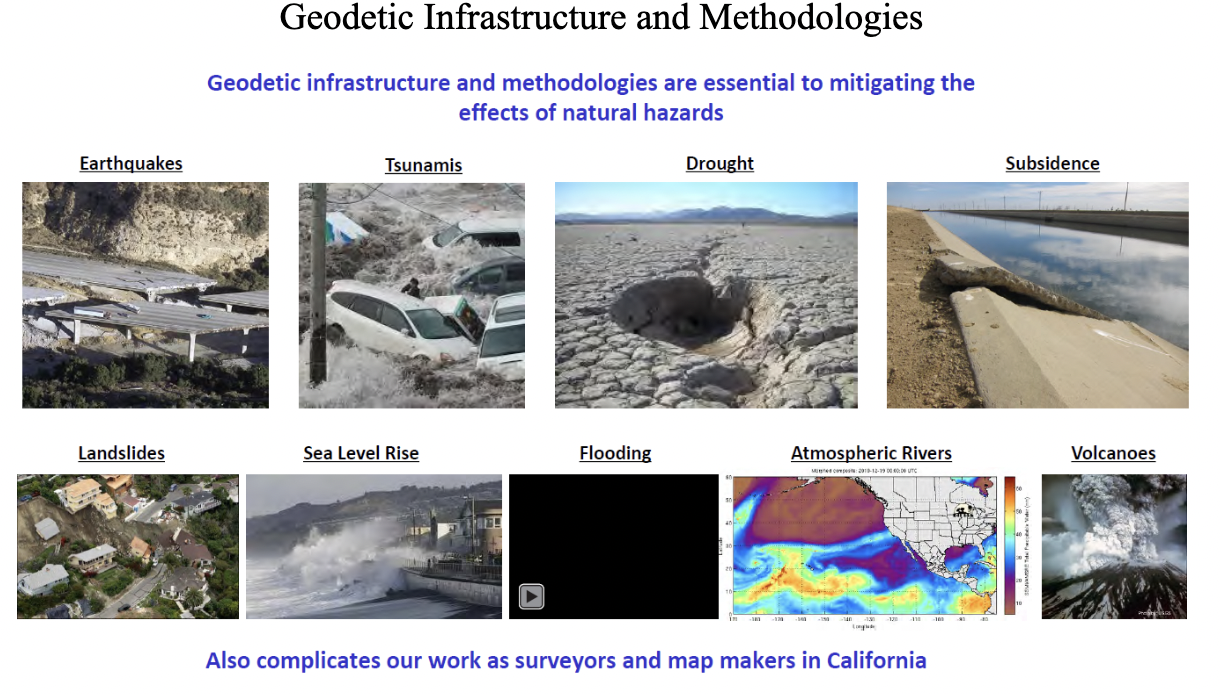
    In my February 2024 GPS World Survey Scene newsletter, I highlighted the National Geodetic Survey (NGS) geospatial modeling grant to The Ohio State University (OSU). In my May 2024 GPS World newsletter, I highlighted the grant to Michigan State University (MSU). This newsletter will provide an update on the progress of these grants based on presentations provided at the 2024 Hydrographic Survey Review Panel (HSRP) Fall Meeting. The Hydrographic Survey Review Panel is a federal advisory committee that provides the National Oceanic and Atmospheric Administration (NOAA) with advice. The National Ocean Service program offices – NGS, the Center for Operational Oceanographic Products and Services (CO-OPS), the Office of Coast Survey (OCS), as well as the University of New Hampshire’s Joint Hydrographic Center and Center for Coastal and Ocean Mapping, provide updates related to their products and services. Advice from this panel assists in addressing NOAA’s strategic plan.

    The following is the purpose of the HSRP (https://nauticalcharts.noaa.gov/hsrp/):

    The HSRP is a federal advisory committee that provides NOAA with independent advice on improving the quality, efficiency, and usefulness of NOAA’s navigation-related products, data, and services. The HSRP advises the NOAA Administrator about its navigation (i.e. nautical charts and ENCs), physical oceanographic (i.e. tides & water levels), geospatial, positioning, and coastal and shoreline programs, products, and services. There are two public meetings each year in different port regions at which public comments from stakeholders and partners are sought. Most of the meetings include webinar capability for those not in the area.

    See an excerpt below of the agenda for the three-day meeting. These meetings are open to the public and I would encourage anyone interested in the activities of these program offices to participate in the meetings. Participants can attend in person or virtually via webinar. I participated in the meeting in virtual mode. The HSRP website provides links to reference documents, presentations, and recordings.

    This newsletter will highlight the session on the NGS Geospatial Modeling grants.

    Excerpt from the HSRP 2024 Fall Meeting Agenda

    September 24, 2024

    Presentations:

    Opening and welcome

    • Mr. Sean M. Duffy, Sr
    • Mr. Mark Schrupp
    • Sen. Peters (MI), video
    • Rep. Theander (MI), video
    • Ms. Rachael Dempsey
    • RDML Benjamin Evans

    Opportunities and Challenges for the NOS’s Navigation Observations and Positioning Portfolio

    • Moderator: Ms. Rachael Dempsey
    • Dr. Larry Mayer
    • Dr. Marian Westley
    • RDML Benjamin Evans
    • Dr. Shachak Pe’eri
    • Directors FSK update

    Local, Regional, State Stakeholder and Partner Perspectives on NOAA Navigation Services

    • Moderator: Mr. Eric Peace
    • Capt. Richard Armstrong
    • Mr. Paul LaMarre
    • Capt. Tony Brandano
    • Capt. Peter Barry
    • Mr. Derek Cusimano

    Underserved Communities Mapping and Charting needs in the Great Lakes Region

    • Moderator: Mr. Nathan Wardwell
    • Dr. Jennifer Boehme
    • Ms. Stephanie Gandulla
    • Mr. Ed Bailey

    September 25, 2024

    Vdatum

    • Dr. Shachak Pe’eri

    International Great Lakes Datum (IGLD)

    • Dr. Jacob Heck
    • Ms. Sierra Davis

    HSRP Working group:

    • HSRP Technical Working Group Report

    September 26, 2024

    NGS Geospatial Modeling Grants

    • Moderator: Mr. Galen Scott
    • Dr. Jeff Freymueller (Ph.D.)
    • Ms. Mara Figueroa Berrocá

    Great Lakes Perspectives on National Drivers

    • Moderators: Mr. Nathan Wardwell and Mr. Eric Peace
    • Ms. Erika Jensen
    • Mr. John Bratton
    • Mr. Mark Breederland
    • Mr. Ryan Chatland

    NOAA Center of Excellence for Operational Ocean and Great Lakes Mapping

    • Capt. Andy Armstrong

    Webinar recordings:

    The session on NGS geospatial modeling grants provided updates by representatives from MSU (Jeff Freymueller) and OSU (Mara Figueroa Berroca). I have provided a few highlights below, but I encourage everyone to download the presentations and/or listen to the daily recording.

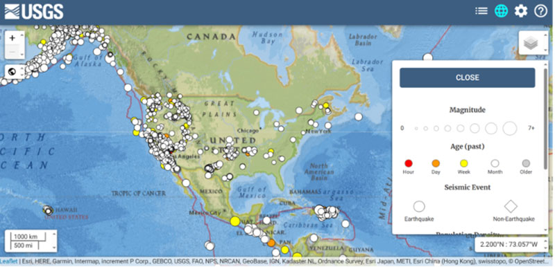
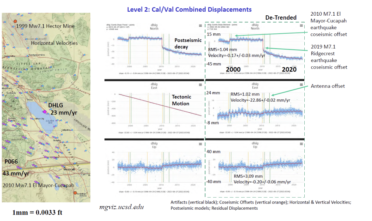
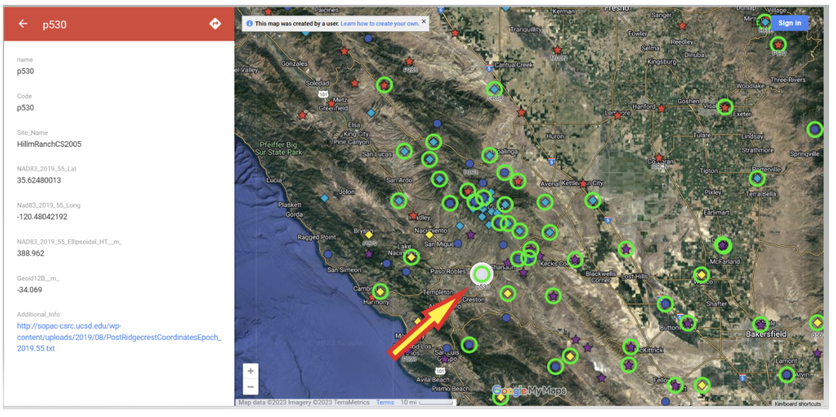
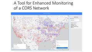
    Freymueller highlighted that keeping the error in coordinates small in a spatial reference system is hard to do in a deforming Earth. This is very important to all users of the National Spatial Reference System (NSRS). Not all CORS are created equal, and their coordinates can change based on various factors such as earthquakes, equipment changes, and local deformation due to the extraction of groundwater. Therefore, efficiently and effectively monitoring the CORS is necessary to quickly identify issues and correct coordinate values in a timely manner. MSU developed a CORS Dashboard that provides a tool for monitoring CORSs. Freymueller provided a slide depicting an example of a CORS in California. See the image below.

    MSU CORS dashboard. (Photo: HSRP Website)
    MSU CORS dashboard. (Photo: HSRP Website)
    Plots of GLO2. (Photo: HSRP Website)
    Plots of GLO2. (Photo: HSRP Website)

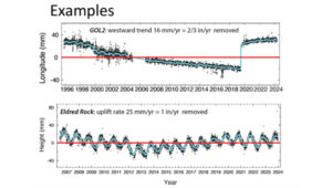
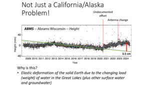
    That said, Freymueller stated that crustal deformation and changes in CORS coordinates is not just a California issue. He provided a slide of a plot of a station in Wisconsin (see the image below.) The plot highlights changes in values where there’s an undocumented offset, a change in antenna, and an elastic deformation due to a change in water load in the Great Lakes.

    Plot of ABMS. (Photo: HSRP Website)
    Plot of ABMS. (Photo: HSRP Website)

    As previously mentioned, keeping the error in coordinates small in a spatial reference system is hard to do in a deforming Earth, especially when so many factors affect coordinates, such as the changing load of water on the Great Lakes. The MSU CORS Dashboard will provide a tool for monitoring the CORS and identifying issues associated with coordinates of the CORSs.

    The MSU CORS Dashboard plans include having different modules for various purposes:

    Compare Solutions:

    • With other solutions
    • With Velocity Model

    Compute and Display Metrics and select CORS stations based on metrics.

    • Earthquake and Postseismic Deformation Modeler:
      • Ingest fault model solutions and generate predictions
      • Statistics on agreement of different fault models
        • How well do the range of geophysical models agree?
    • Forward predict postseismic deformation

    The MSU CORS Dashboard provides information about CORSs that could be useful to surveyors and mappers when performing and analyzing a GNSS survey project. For example, one module will compute and display metrics about individual CORSs, providing surveyors with the appropriate information to select the best CORSs for their GNSS project. NGS and MSU will determine how this CORS Dashboard is incorporated into NGS products and services.

    Another phase of the MSU geospatial modeling grant included developing a geodesy program to help address the U.S. geodesy crisis. The presentation provided several slides with information on students obtaining a master’s degree in geodesy. The coursework for the two-year online program is divided into four thematic areas: Foundations of Geodesy, Fundamentals of Geodesy and Geophysics, Mathematical and Computational Concepts, and Geodetic Methods and Applications. Students will take a mix of courses (no thesis) from the consortium institutes – MSU, Michigan Technological University (MTU and the University of Alaska Fairbanks (UAF).

    The following is a Timeline for Development:

    • 2024: Develop University consortium agreements and establish structure for master’s program
    • 2024/2025: Develop courses
    • Fall 2025: Launch program with first class of students

    Freymueller mentioned that the timeline for launch currently feels optimistic due to bureaucratic hurdles dealing with the consortium agreements, but they are continuing work on the development of courses. Further newsletters will provide updates on the progress of the program.

    Outline of Geodesy Master’ Degree

    Foundations of Geodesy

    Courses:

    • Map Projections (MSU)
    • Geodetic Models (MTU)
    • Both courses required
    • Courses provide backgrounds in mapping, projections, datums, reference frames, and transformations.

    Fundamentals of Geodesy and Geophysics

    Courses:

    • Modern Geodesy and Applications (MSU) or Geodetic Methods and Applications (UAF)
    • Geodetic Data Processing and Analysis (MSU)
    • Solid Earth Geophysics and Geodynamics (MSU) or Foundations of Geophysics (UAF)
    • Positioning with GNSS (MTU)
    • Students choose at least 2 courses
    • Courses provide background in geodetic theory (including orbit determination and GNSS and imaging satellite systems), measurement and interpretation of steady state and time variable motions within the solid Earth, cryosphere, and hydrosphere, data processing, and geophysical modeling.

    Mathematical and Computational Concepts

    Courses:

    • Introduction to Numerical Tools for Earth and Environmental Sciences (MSU)
    • Programming and Automation for Geoscientists (UAF)
    • Data Analysis and Adjustments (MTU)
    • Inverse Problems and Parameter Estimation (UAF)
    • Numerical Analysis (UAF)
    • Students choose at least 2 courses
    • Courses will provide foundation in programming and mathematical techniques (including inversion theory and linear regression) essential for geodesy

    Geodetic Methods and Applications

    Courses:

    • 3D Surveying and Modeling with Laser Scanning Data (MTU)
    • Advanced Photogrammetry – Satellite Photogrammetry (MTU)
    • Microwave Remote Sensing (UAF)
    • InSAR and Its Applications (UAF)
    • Digital Image Processing in Geosciences (UAF)
    • Design of Geodetic Networks (MSU)
    • Advanced Hydrogeology (MSU)
    • Students choose at least one course
    • Courses extend knowledge into additional land- and satellite geodetic techniques, network design, and geophysical applications

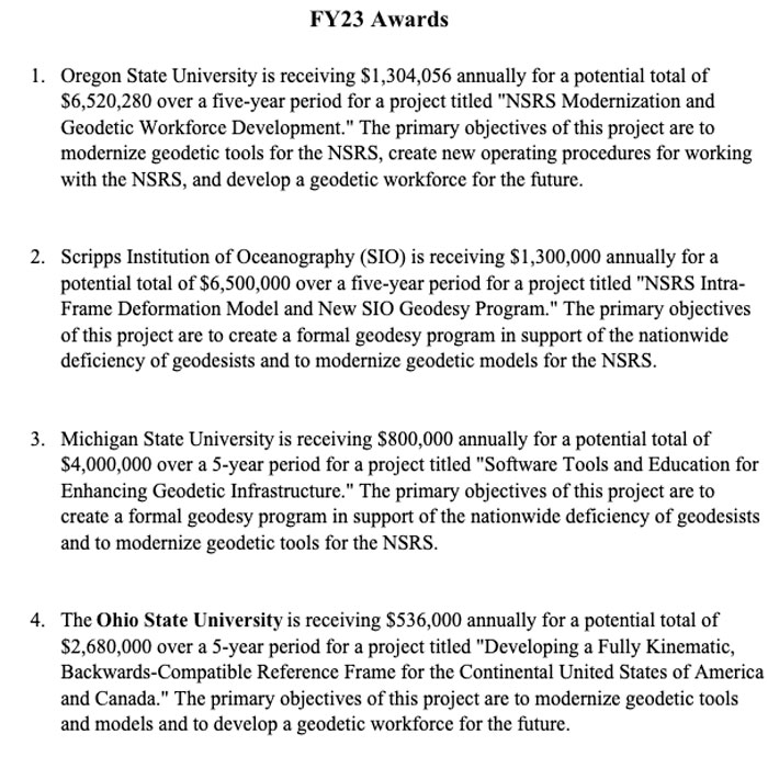
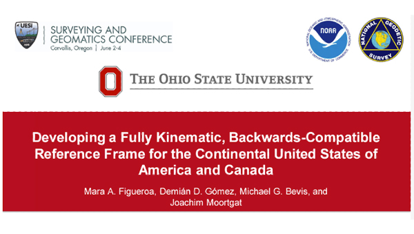
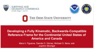
    The second presentation on the geospatial modeling grants was titled “Developing a Fully Kinematic, Backwards-Compatible Reference Frame for the Continental United States of America and Canada,” presented by Mara A. Figeroa, OSU.

    OSU Presentation. (Photo: HSRP Website)
    OSU Presentation. (Photo: HSRP Website)

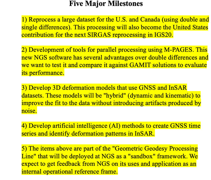
    Figeroa outlined the following project goals:

    • Development of the operational (sandbox) kinematic reference frame (KRF).
      • Develop automation processes to detect and model deformation resulting from earthquakes, GIA and other crustal motions.
    • Parallelization wrapper for M-PAGES (adapted from our existing Parallel.GAMIT)
      • Process all existing data in the U.S. and Canada
    • Creation of Intraframe deformation models (i.e. trajectory prediction models)
      • Use GNSS and InSAR aided by AI to access the conventional epoch of the frame.
      • Provide the users with maps of “stable areas” to facilitate access to the frame using differential processing.

    Figeroa noted that the coordinates and model parameters defining the reference frame are time-dependent in a National-Level Kinematic Reference Frame (KFR). The KFR needs to provide multiple conventional epochs that are accessible to all users anytime and anywhere to guarantee topologic homogeneity. Models need to be updated to account for the changes in coordination due to earthquakes and other deformation events. Figeroa stated, “Kinematic implies constant update of the reference frame parameters to ‘honor’ the frame’s internal geometry.”

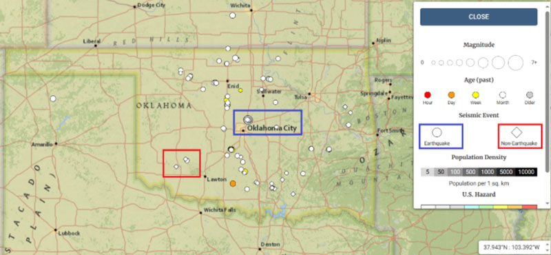
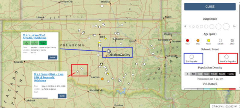
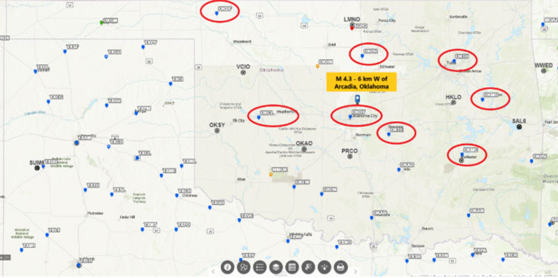
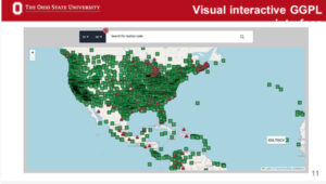
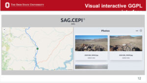
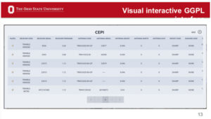
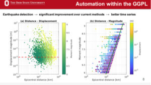
    OSU has developed what they denote as a Geometric Geodesy Processing Line (GGPL) to evaluate and analyze CORSs data. They are processing all CORSs data to identify issues with the data that could be due to various factors such as crustal deformation and equipment changes. The tool highlights stations with a potential warning flag issue (see OSU Interactive GGPL).

    OSU Interactive GGPL. (Photo: HSRP Website)
    OSU Interactive GGPL. (Photo: HSRP Website)

    The system is automated, but they have developed interactive visual tools so researchers can review the results of each station. The visual interactive GGPL provides metadata about the station such as coordinates, maps, photos, and dates of installation of equipment.

    OSU Interactive GGPL - Location and Photo. (Photo: HSRP Website)
    OSU Interactive GGPL – Location and Photo. (Photo: HSRP Website)
    OSU Interactive GGPL - Equipment. (Photo: HSRP Website)
    OSU Interactive GGPL – Equipment. (Photo: HSRP Website)
    OSU Interactive GGPL – Coordinates and Other Metadata. (Photo: HSRP Website)
    OSU Interactive GGPL – Coordinates and Other Metadata. (Photo: HSRP Website)

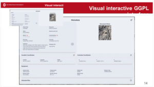
    One feature of the GGPL is that it generates plot changes in coordinates over time (see the image below). I recently participated in a School of Earth Science Advisory board meeting at OSU and visited with Demian Gomez, Ph.D., the project’s lead principal investigator.

    Demian demonstrated the GGPL tool for me. I was really impressed at how fast the system was, as well as how much information it provided in a user-friendly format. In my June 2024 GPS World Survey Scene newsletter, I highlighted an issue I found with an antenna change at a CORS in Texas. I ask Demian to pull up the information for the same site. The GGPL highlighted the same antenna change and shift in coordinates that I found. This feature is important to developing an intraframe deformation model (IFDM). How NGS will use this in the development of the IFDM2022 for the new, modernized NSRS will be determined later by NGS.

    Intraframe Deformation Model. (Photo: HSRP Website)
    Intraframe Deformation Model. (Photo: HSRP Website)

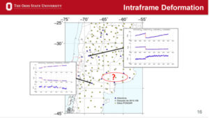
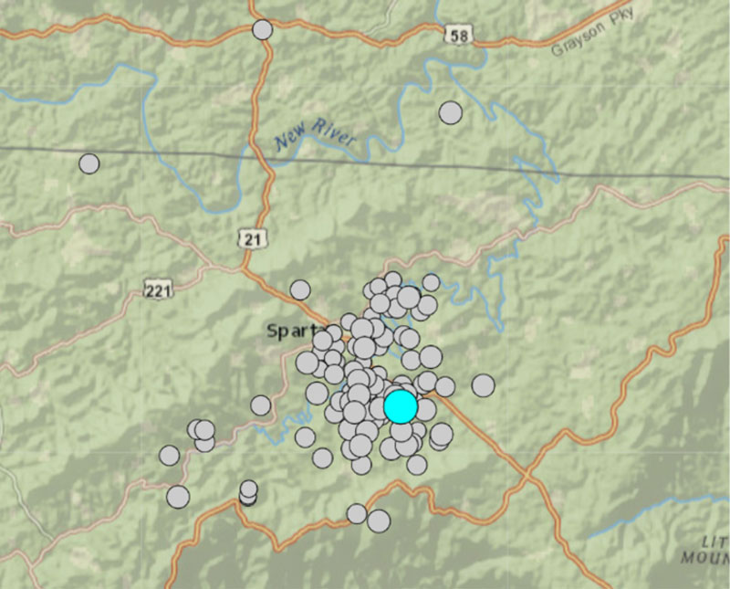
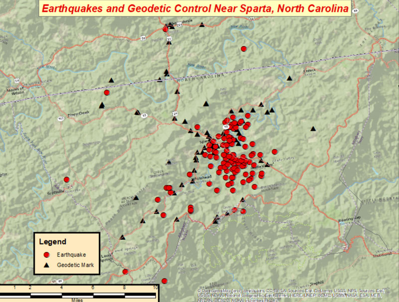
    An important aspect of an IFDM is to identify and model changes in coordinates due to crustal deformation. As mentioned by Freymueller, modeling earthquake and other deformation events is extremely important to maintaining an accurate spatial reference frame. OSU GGPL tool assists in identifying potential deformation due to earthquakes.

    OSU Interactive GGPL – Detection of Earthquakes. (Photo: HSRP Website)
    OSU Interactive GGPL – Detection of Earthquakes. (Photo: HSRP Website)

    OSU’s process includes developing trajectory prediction models (TPM). Trajectory prediction models need to be continuous in space and time to predict the behavior of passive benchmarks. Accurate trajectory prediction models will ensure access to a geodetic reference frame after big earthquakes utilizing accurate post-seismic coordinates. OSU’s process includes developing techniques for observing GNSS networks in sparse areas to improve the model’s predictability. My May 2024 GPS World Survey Scene newsletter highlighted Demián’s extensive experience modeling time-dependent coordinates and several papers published in the Journal of Geodesy addressing this topic. The papers have demonstrated the model’s effectiveness in earthquakes in Argentina and have developed tools that provide coordinates in updated reference frames based on the models. This is important to users of the new, modernized NSRS because the accuracy of the IFDM2022 model is vital to providing accurate Reference Epoch Coordinates (RECs) in the new, modernized NSRS. See my August 2022 GPS World Survey Scene Newsletter for information on RECs and my May 2024 GPS Newsletter for more details on Demián’s work.

    Model of Co-seismic Component. (Photo: HSRP Website)
    Model of Co-seismic Component. (Photo: HSRP Website)

    This newsletter highlighted the progress that OSU and Michigan State University have made in developing tools that will be useful for developing and implementing the new, modernized NSRS in 2025.
    As I previously mentioned, I would encourage everyone to download the presentations and recordings for more details. The recording of the session on NGS Geospatial Grants can be found on the Sept. 26, 2024, recording. (The session on NGS Geospatial Grants starts at 1:02:45 on the recording.)
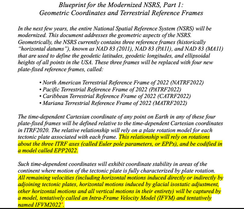
    Similarly to my previous newsletter, I want to remind everyone that in less than a year, NGS will finalize the new terrestrial reference frames and geopotential datum. Time really is running out and users need to obtain a working knowledge of the new, modernized National Spatial Reference System.

    NGS publicly-given presentations that have been collected for viewing by the public can be downloaded at https://geodesy.noaa.gov/web/science_edu/presentations_library/.

  • Scripps Institution of Oceanography establishes a geodesy program

    Scripps Institution of Oceanography establishes a geodesy program

    In my November 2023 GPS World newsletter, I highlighted the announcement made by the National Geodetic Survey (NGS) of the recipients of the NOAA FY 23 Geospatial Modeling Competition Awards. The grantees’ proposals include developing models to address what NGS denotes as the Intra-Frame Deformation Model (IFDM). The primary objectives of these projects are to modernize geodetic tools and models, as well as to develop a geodetic workforce for the future. A significant improvement in the new, modernized National Spatial Reference System (NSRS) is the time-dependent component being incorporated in the computation of reference epoch coordinates (RECs). That said, developing models that accurately capture the time-dependent component is extremely important to providing reliable, consistent, and accurate RECs. My February 2024 newsletter highlighted NGS’s grant to The Ohio State University for developing a fully kinematic reference frame for the Continental United States and Canada. Similar to the OSU project, a goal of the Scripps Institution of Oceanography (SIO) project is to provide an accurate IFDM, which will provide reliable, consistent and accurate RECs. On Jan. 10, 2024, Yehuda Bock, Ph.D., gave a presentation about this at the general membership meeting of the American Association for Geodetic Surveying (AAGS). His presentation can be downloaded from the AAGS’s website: https://aagsmo.org/.

    Summary of the SIO Geospatial Award. (Image: NGS website)
    Summary of the SIO Geospatial Award. (Image: NGS website)

    Bock is director of the California Spatial Reference Center (CSRC), which is responsible for “establishing and maintaining an accurate state-of-the-art network of GPS control stations for a reliable spatial reference system in California.” I highlighted the CSRC in my June 2023 GPS World Newsletter.

    Yehuda’s proposal included the following three activities:

    • Create a formal Geodesy Program at SIO to address the nationwide deficiency of geodesists. Expand current geophysics curriculum – funding for five graduate students.
    • Develop an IFDM to supplement the NSRS for users in regions with significant ground motions, using GNSS and InSAR/GNSS displacement fields (funded by NASA projects) and underlying geophysical models. CSRC will exercise the IFDM through its community of public, private and academic users of precise spatial referencing in our challenging region of secular and transient crustal movements.
    • Investigate a unified vertical reference frame, including a marine geoid optimized to be consistent with the full spectrum of observations from modern gravimetric geoids (e.g., GRAV-D, ICGEM), remotely sensed observations (e.g., SWOT, ICESat-2), in situ ocean observations and assimilating ocean models and the TRF.

    Yehuda’s project includes creating a formal geodesy program at SIO that will help to address the geodesy crisis. Anyone keeping up with my columns knows that I have been highlighting the geodesy crisis and programs that advance the science of geodesy (July 2020, November 2022, and December 2022).

    Yehuda showed a slide that highlighted “What Geodesy Can Tell Us About Earth.”  Looking at the slide, geodesists are needed in the field of climatology, meteorology, hydrology, geology, volcanology, oceanography, and glaciology, as well as surveying, mapping, and navigation. All these disciplines study Earth’s dynamic processes and involve geodesy.

    From Dr. Yehuda Bock Presentation to the AAGS General Membership Meeting. (Image: AAGS website)
    From Yehuda Bock Ph.D.’s presentation to the AAGS General Membership Meeting. (Image: AAGS website)

    The images “Geodesy Curriculum at SIO (PhD, MSc)”, “Geodesy Courses – 1” and “Geodesy Courses – 2” provide information about the Geodesy Program as SIO.

    From Dr. Yehuda Bock Presentation to the AAGS General Membership Meeting. (Image: AAGS website)
    From Yehuda Bock, Ph.D.’s Presentation to the AAGS General Membership Meeting. (Image: AAGS website)

    Notice that some of the courses focus on topics that are important to real world applications. For example, GNSS precise point positioning applications to seismotectonics, GNSS signal propagation applications to atmospheric remote sensing and GNSS reflection: soil moisture and sea level and the vertical datum.

    From Dr. Yehuda Bock Presentation to the AAGS General Membership Meeting (Image: AAGS website)
    From Dr. Yehuda Bock Ph.D.’s presentation to the AAGS General Membership Meeting. (Image: AAGS website)
    PhotoFrom Dr. Yehuda Bock Presentation to the AAGS General Membership Meeting (Image: AAGS website)
    FromYehuda Bock, Ph.D.’s presentation to the AAGS General Membership Meeting. (Image: AAGS website)

    In addition to the graduate-level courses, they are proposing an undergraduate course titled Geodesy and Geospatial Information. The purpose of the course is to provide students with the skills in geospatial systems that will provide opportunities for eventual employment in the public and private sectors.


    Proposed Undergraduate Course

     Title: Geodesy and Geospatial Information

    Course justification and content objectives: Geodesy is the study of Earth’s size (geometry), shape (gravity field) and deformations (e.g., plate tectonic motions, subsidence). It provides access to a well-defined spatial reference system for precise geospatial information (latitude, longitude, height, elevation with respect to sea level) used for positioning, navigation, surveying and mapping. Geodesy is also an important discipline within the earth, atmospheric and oceanographic sciences, using observations of GPS and other satellite navigation constellations, remote sensing platforms (satellite and drone), and various terrestrial sensors. It is a data- and analysis-intensive discipline increasingly requiring modern data science methods. This introductory course will provide students with a solid background in geospatial systems for eventual employment in the public and private sectors. The course will also serve as a pipeline to the geodesy track at SIO/Earth Sciences and to other academic institutions and to alleviate the nationwide deficiency of geodesists. The objective is to provide basic knowledge of geodetic concepts for Earth and data scientists and the underlying geodetic framework for precise spatial information.

    Learning objectives:

    • Acquire basis concepts of geodetic science.
    • Provide overview of geodetic instrumentation and observations.
    • Develop elementary skills in geodetic data analysis.
    • Explore existing geodetic infrastructure and data repositories.
    • Experience hands on visualization and manipulation of geospatial information.
    • Understand the underlying geodetic framework for precise spatial information systems.
    • Provide example of data science applications in solving geodetic problems.

    Preferred background: statistics, linear algebra, Matlab/Python


    In my opinion, universities should provide a general elective course for undergraduate students that provides an introduction in how geodesy influences your daily routines. For example, how does my phone know where I am and how does it know the best route I should take to get to my destination?

    How Does My Phone Know Where I Am? (Image: Dave Zilkoski)
    How Does My Phone Know Where I Am? (Image: Dave Zilkoski)

    The second task in the SIO proposal is to develop an IFDM. The concept of an IFDM is part of NGS’ modernized, NSRS. Several of my previous My July 2023 GPS World newsletter highlighted a presentation by Yehuda discussing a kinematic datum that uses an intra-frame velocity model to estimate positions at any time with respect to a reference frame and epoch.

    As I mentioned in my July 2023 newsletter, California’s geodetic network is significantly affected by crustal movement. To help address this issue, the CSRS updated the NAD 83 coordinates, it is denoted as CSRS epoch 2017.5 (NAD 83). Part of the implementation of the CSRC epoch 2017.50 (NAD 83) was to have the new epoch-date coordinates transmitted with RTCM 3.0 data streams. This is something that other RTN operators from around the nation will have to do after NGS publishes the NSRS coordinates. The CSRS is a model from which others can learn.

    During his presentation to AAGS, Yehuda highlighted his methodology of integrating InSAR and GNSS to develop an IFDM that provides for higher spatial resolution to improve the model between GNSS stations.

    The boxes titled “SCIP Dynamic Datum Utility” and “Output from SCIP Utility” provide an example of an input and output of the utility, and the box titled InSAR/GNSS Integration for Higher Spatial Resolution” is a conceptual diagram of the concept.

    Not only has this abbreviation been spelled out before, but here the full phrase appears three times, in three consecutive sentences.

    SCIP Dynamic Datum Utility. (Image: SOPAC website)
    SCIP Dynamic Datum Utility. (Image: SOPAC website)
    Output from SCIP Utility. (Image: (SOPAC Website)
    Output from SCIP Utility. (Image: (SOPAC Website)
    From Yehuda Bock Ph.D.'s Presentation to the AAGS General Membership Meeting (Image: AAGS website)
    From Yehuda Bock Ph.D.’s Presentation to the AAGS General Membership Meeting
    (Image: AAGS website)

    The image provides an example of the concept in the San Joaquin Valley, California.

    InSAR/GNSS Integration Example.
    InSAR/GNSS Integration Example.

    The following statement is in the note section of the slide:

    “Area of subsidence in San Joaquin Valley. Our weekly displacement time series at GNSS station P056 shows significant changes in subsidence rate over the period 2006 to 2022, for a total of 3.3 feet that reflects periods of drought and increased groundwater use. On the upper right is the InSAR time series at that location for a shorter period of time.”  This shows the potential of using InSAR to improve the IFDM in areas of sparse CORS.

    The third item in the proposal is to “Investigate a unified vertical reference frame, including a marine geoid optimized to be consistent with the full spectrum of observations from modern gravimetric geoids (e.g., GRAV-D, ICGEM), remotely-sensed observations (e.g., SWOT, ICESat-2), in situ ocean observations and assimilating ocean models, and the TRF.”

    The images below provide a list of the reference surfaces involved in unifying the vertical reference frames and the observing systems involved in the project. Understanding the geoid at the land-sea interchange is important to estimating accurate GNSS-derived orthometric heights along the coast as well as in the oceans. My August 2021 newsletter highlighted the concept of establishing an International Height Reference System (IHRS) so that all countries could provide physical heights across their boundaries and over the oceans. This project would support that international activity.

    From Yehuda Bock Ph.D. Presentation to the AAGS General Membership Meeting. (Image: AAGS website)
    From Yehuda Bock Ph.D.’s Presentation to the AAGS General Membership Meeting. (Image: AAGS website)
    From Yehuda Bock Ph.D.'s Presentation to the AAGS General Membership Meeting. (Image: AAGS website)
    From Yehuda Bock Ph.D.’s Presentation to the AAGS General Membership Meeting. (Image: AAGS website)

    This newsletter and my previous GPS World newsletter highlighted two of the grantees, \SIO and OSU, which included developing models to address what NGS denotes as the IFDM.

    The SIO program includes creating a formal geodesy program at SIO that will help to address the geodesy crisis. In addition to the graduate level courses, they are proposing an undergraduate course that will provide students with the skills in geospatial systems that will provide opportunities for eventual employment in the public and private sectors. My next newsletter will address another NGS geospatial modeling grant awardee – Oregon State University’s proposal.

  • OSU grant proposal includes developing time-dependent models for the new, modernized NSRS

    OSU grant proposal includes developing time-dependent models for the new, modernized NSRS

    In my November 2023 GPS World newsletter, I highlighted the announcement made by the National Geodetic Survey (NGS) of the recipients of the National Oceanic and Atmospheric Administration (NOAA) FY 2023 Geospatial Modeling Competition Awards. As stated in the newsletter, NGS awarded the grants for projects that will research emerging problems in the field of geodesy and develop tools and models to advance the modernization of the National Spatial Reference System (NSRS). A significant improvement in the new, modernized NSRS is the time-dependent component being incorporated in the computation of reference epoch coordinates (RECs). That said, developing models that accurately capture the time-dependent component is extremely important to providing reliable, consistent, and accurate RECs. This is not a simple problem to solve. Two of the grantees, Scripps Institution of Oceanography (SIO) and The Ohio State University (OSU) include developing models to address what NGS denotes as the Intra-Frame Deformation Model (IFDM).

    This newsletter is going to highlight OSU’s geospatial award and my March newsletter will highlight the SIO proposal.

    Summary of the OSU Geospatial Awards. (Image: NGS website)
    Summary of the OSU Geospatial Awards. (Image: NGS website)

    The time-dependent models for the new, modernized NSRS — that is, Euler pole parameters (EPP) and Intra-Frame Deformation Model (IFDM)] — are discussed in NOAA Technical Report NOS NGS 62, “Blueprint for the Modernized NSRS, Part 1: Geometric Coordinates and Terrestrial Reference Frames” and NOAA Technical Report NOS NGS 67, “Blueprint for the Modernized NSRS, Part 3: Working in the Modernized NSRS.” The EPP2022 and IFDM2022 models will make time-dependent geodetic control useable for most surveyors, engineers, and geospatial users.

    So, what are EPP2022 and IFDM2022? What does it mean to users of the new, modernized NSRS? Basically, the EPP model changes the reference frame of the coordinates but not the epoch and the IFDM model changes the epoch of the coordinates but not the reference frame.

    Photo:

    As previously mentioned, these models are defined in detail in Blueprint Part 1 and Blueprint Part 3.

    Photo:

    Photo:

    For the OSU grant proposal, I had the opportunity to talk with Dr. Demián Gómez, the lead principal investigator (PI) for the OSU grant. Demián has extensive experience in modeling time-dependent coordinates and is the lead author on several papers published in the Journal of Geodesy that address this topic.

    Articles by Gómez in the Journal of Geodesy

    • Gómez, D., Piñón, D.A., Smalley, R. et al (2015) Reference frame access under the effects of great earthquakes: a least squares collocation approach for non-secular post-seismic evolution. J Geod. https://doi. org/10. 1007/s00190-015-0871-8
    • Gómez, D.D., Bevis, M. G. & Caccamise, D.J. Maximizing the consistency between regional and global reference frames utilizing inheritance of seasonal displacement parameters. J Geod 96, 9 (2022). https://doi. org/10. 1007/s00190-022-01594-0
    • Gómez, D.D., Figueroa, M. A., Sobrero, F. S. et al. On the determination of coseismic deformation models to improve access to geodetic reference frame conventional epochs in low-density GNSS networks. J Geod 97, 46 (2023). https://doi. org/10. 1007/s00190-023-01734-0

    In his latest paper, titled “On the determination of coseismic deformation models to improve access to geodetic reference frame conventional epochs in low-density GNSS networks,” the authors applied their methodology to two earthquakes in Chile: the 2010 Maule and 2015 Illapel earthquakes. The paper describes their methodology for estimating coseismic displacements in areas with low-density continuous GNSS coverage by using geophysical models in a hybrid (dynamic-kinematic) mode. Their methodology provided coseismic estimates on survey GNSS stations with rms (95% confidence interval) residuals of ~ 3 cm for Maule, and ~ 2 cm for Illapel. They also tested their models using InSAR and found that the models correctly predicted the near-field deformation. The authors believe that their methodology to obtain coseismic surface displacement models, based on a spherical layered Earth, for GNSS trajectory prediction models (TPMs) using sparse GNSS data represents a major improvement relative to coseismic models incorporated in TPMs, such as NGS’s Horizontal Time-Dependent Positioning model (HTDP) and Transformations in Four Dimensions (TRANS4D). This is important to users of the new, modernized NSRS because the accuracy of the IFDM2022 model is important to providing accurate RECs in the new, modernized NSRS.

    Most individuals in the United States associate earthquakes with California, but earthquakes occur every day in NGS’s area of responsibility. The USGS has a website that lists the location and magnitude of earthquakes.

    PLot of earthquakes — 12/21/2023 to 01/20/2024. (Image: USGS website)
    Plot of earthquakes — 12/21/2023 to 01/20/2024. (Image: USGS website)

    The box below highlights the earthquakes in the conterminous United States during a 30-day period. Most of these earthquakes have small magnitudes. The question is, what effects do these earthquakes have on nearby published marks in the NSRS?

    Plot of earthquakes in CONUS — 12/21/2023 to 01/20/2024. (Image: USGS website)
    Plot of earthquakes in CONUS — 12/21/2023 to 01/20/2024. (Image: USGS website)

    The website provides information on both earthquake and non-earthquake events.

    Plot of earthquakes in Oklahoma — 12/21/2023 to 01/20/2024. (Image: USGS website)
    Plot of earthquakes in Oklahoma — 12/21/2023 to 01/20/2024. (Image: USGS website)

    I was wondering what it meant by non-earthquake events, so I clicked on some of the icons. As indicated on the plot, a quarry blast registered on the USGS system. Again, the question is, do these earthquakes and non-earthquake events affect the coordinates of marks in the ground?

    Plot of non-earthquakes in Oklahoma. (Image: USGS website)
    Plot of non-earthquakes in Oklahoma. (Image: USGS website)

    Something to note in the plots of Oklahoma is the large number of earthquakes around Oklahoma City during a 30-day period.

    Plot of earthquakes north of Oklahoma City. (Image: USGS website)
    Plot of earthquakes north of Oklahoma City. (Image: USGS website)

    Notice that there are several CORSs that surround the location of the earthquakes but only one CORS is close to the area. The box below shows a plot of CORS surrounding the area of earthquakes.

    Demián’s latest paper describes their methodology for estimating coseismic displacements in areas with low-density continuous GNSS coverage by using geophysical models in a hybrid (dynamic-kinematic) mode. Since many earthquakes occur throughout the United States, it will be interesting to see how well this approach will work in the development of an Intra-Frame Deformation Model.

    Earthquake M 4. 3 - 6 km W of Arcadia, Oklahoma. (Image: NGS website)
    Earthquake M 4. 3 – 6 km W of Arcadia, Oklahoma. (Image: NGS website)

    Photo:

    Photo:

    As previously stated, outside of California, most of these earthquakes have small magnitudes. That said, on August 9, 2020, a magnitude 5.1 earthquake occurred in Sparta, North Carolina. There were reports of damage to roads, water mains, and structures, but what were the effects on nearby published marks in the NSRS?

    North Carolina Sparta Earthquake

    (https://en. wikipedia. org/wiki/2020_Sparta_earthquake)

    The 2020 Sparta earthquake was a relatively uncommon intraplate earthquake that occurred near the small town of Sparta, North Carolina, on August 9, 2020 at 8:07 am local time. The earthquake had a moment magnitude of 5.1, and a shallow depth of 7.6 kilometres (4.7 mi). [2] Shaking was reported throughout the SouthernMidwestern, and Northeastern United States. [9] It was the strongest earthquake recorded in North Carolina in 104 years,[10] the second-strongest in the state’s history,[11] and the largest to strike the East Coast since the 2011 Virginia earthquake. [12][13]

    Impacts[edit]

    Damage[edit]

     Widespread damage occurred in Sparta, which had already been debilitated by the COVID-19 pandemic in North Carolina. [23] Damages include collapsed ceilings, chimneys, and masonry; damaged water mains; cracked and deformed roads; uprooted headstones; and displaced appliances and items. [24][23][25] Wes Brinegar, the town’s mayor, issued a state of emergency to apply for FEMA and state financial aid. [25][23] Damage was worse than initially thought, with at least 525 structures being damaged, and 60 with major damage, meaning at least 40% of the structure was a total loss. Nineteen people lost their homes, 25 were declared uninhabitable, and scammers took advantage of the damage, charging people up to $500 USD for repairs, but never showing up.[26]

    Governor of North Carolina, Roy Cooper, toured the damage in Sparta, releasing a statement later, stating “We’ve dealt with a hurricane, a violent tornado, and now an earthquake all in the middle of a pandemic: North Carolinians are resilient.”[27]

    The box below shows the locations of earthquakes that occurred near Sparta, North Carolina. The plot indicates that there was not just one earthquake in the area, but many that may have affected the coordinates of monuments in the region.

    Plot of earthquakes near Sparta, North Carolina. (Image: USGS website)
    Plot of earthquakes near Sparta, North Carolina. (Image: USGS website)

    Photo:

    The image below shows the locations of earthquakes and NGS published geodetic marks in the Sparta region.

    Image: Dave Zilkoski
    Image: Dave Zilkoski

    Again, the real issue that needs to be addressed is what effect do these earthquakes and other geophysical activities such as subsidence have on the coordinates of geodetic marks in the region?

    OSU’s grant proposal includes merging GNSS and InSAR using deep learning to better estimate the Intra-Frame Deformation Model. Obviously, developing time-dependent models for the new, modernized NSRS is very complex and technical. I contacted Demián and asked him for a list of his major milestones associated with his project.

    Photo:

    Based on Demián’s major milestones, I had a few follow-up questions.

    1) Reprocess a large dataset for the U.S. and Canada using double and single differences.  This processing will also become the United States’ contribution for the next SIRGAS reprocessing in IGS20.

    I asked Demián if he had an estimate of the amount of data he was talking about?

    He told me that he did not have an exact number yet because they are still adding data. He said that, at this time, they have 878 stations in the US and Canada which amounts to 4,648,269 station days (i.e., 4. 6M RINEX files, just in the US and Canada). This is the latest number he retrieved from his database but this number increases every day (January 16, 2024).  

    2) Development of tools for parallel processing using M-PAGES. This new NGS software has several advantages over double differences and we want to test it and compare it against GAMIT solutions to evaluate its performance.

    Demián stated that M-PAGES has several advantages so I asked him to explain what he meant.

    He told me that one advantage is that it can process all constellations at once using single differences which allows processing of more stations simultaneously. Another advantage is because single differences produce “lighter” systems of equations (compared to double differences), they can process more stations simultaneously.

    3) Develop 3D deformation models that use GNSS and InSAR datasets. These models will be “hybrid” (dynamic and kinematic) to improve the fit to the data without introducing artifacts produced by noise.

    [Note: this approach is described in the paper titled “On the determination of coseismic deformation models to improve access to geodetic reference frame conventional epochs in low-density GNSS networks,” J Geod 97, 46 (2023).] 

    Demián said “they are in the process of collecting all the GNSS data that they can to process and then they will identify which gaps can be filled with InSAR data.”

    I wanted to better understand what Demián meant by “hybrid” model. So, I asked him about his “hybrid” approach and he provided the following explanation:

    When we say “kinematic” we refer to a model that does not consider the underlying mechanism to explain the observed effect. A good example are the trajectory models of GNSS stations that describe their motions as a sum of mathematical functions (there are no physics in them). A dynamic model does use the underlying physics to explain the observations. A “hybrid” model is in the middle: it uses a dynamic model but allows some unrealistic model parameters to improve the data fit.

    I mentioned to Demián that users would be very interested in the spatiotemporal uncertainties of the intra-frame deformation model. I asked him if, at this time, he had any idea of the size or range of uncertainties.

    Demián said “that it will be variable and very dependent on the density of the input data. He said that they are aiming for cm-level uncertainties. Our experience in Argentina tells us that a 5 mm uncertainty level can be achieved on stable regions while about 2 to 3 cm is expected on high deformation areas. We will have to wait and see to understand the model’s performance. ”

    I told Demián that the Houston-Galveston, Texas region of the United States is an area of subsidence that would benefit with an accurate Intra-Frame Deformation Model. The Harris-Galveston Subsidence District has a variety of GNSS CORS and PAMS that are not part of NGS’s CORS. My April 2022 GPS World Newsletter, which included the HGSD CORS and PAMS, described the effects of vertical movement on NGS’s modernized 2022 NSRS. I also asked if he was willing to use this data

    He had a very simple answer: “Absolutely!”  He said “The more data we incorporate, the better the models will describe reality. Part of the project is related to providing a processing line that can handle large amounts of data. The issue with some data is metadata. Metadata and how we collect it is what really prevents us from reaching that “final mm” uncertainty level we are all looking for. We should be pushing very hard on metadata standardization. In my opinion, the biggest problem is twofold: 1) incorrect antenna identification in RINEX files (due to improper data curation) and 2) lack of a unified/globally accessible database of metadata that is adequately cured.”

    4) Develop AI methods to create GNSS time series and identify deformation patterns in InSAR.

    Part of the OSU project is to use ML to improve the development of the IFDM.

    Excerpt from OSU Proposal on trajectory modeling

    Trajectory modeling

    For each station, we will obtain KTM parameters, including their uncertainties, for

    stations velocities (and acceleration if needed), mechanical and/or geophysical jumps (earthquakes), logarithmic transients after earthquakes (following recommendations from Sobrero et al., 2020), and seasonal coordinate variations.  Other parameters for stations affected by volcanic activity, episodic subsidence, etc will also be added when needed.  We routinely generate these KTMs for thousands of GNSS stations (for the definition of our in-house geodetic RF) using software developed within the Division of Geodetic Science at OSU. Earthquake detection is performed automatically following formulations also developed by the project’s PIs.

    Trajectory modeling enhancement using machine learning

    We will enhance the capabilities of the KTMs by including a physics-based machine

    learning (ML) component to the model that automatically detects, e. g., discontinuities in the time series. Detecting and mitigating the effects of mechanical jumps (those generated by unreported equipment changes and other effects) will increase the overall reliability of the GGPL. ML is well suited for this task and indeed ML algorithms like Random Forests have been explored in a recent work (e. g., Crocetti et al., 2021). We will test a similar approach, as well as more sophisticated convolutional neural networks to automatically detect discontinuities in coordinate trajectories. These ML algorithms will be trained on OSU’s database of trajectory models (~4000 stations). Using this ML algorithm we will also automatically detect other ‘harmful’ residuals in the time series. For example, large residuals can appear right after an earthquake if the postseismic transient does not have the appropriate relaxation time, or if two transients are needed to model the event.  

    I find AI and ML fascinating. Basically, machine learning is a field of study in artificial intelligence.

    [As a side note: According to Wikipedia, Alan Turing, a mathematician, was the first person to conduct substantial research in the field that he called machine intelligence. Mr. Turing was considered the father of modern computer science. He was famous for his work in decoding the encryption of German Enigma machines during the second world war, and documenting a procedure, known as the Turing Test, that formed the basis for artificial intelligence. Turing was not directly involved with the successful breaking of these more complex codes, but his ideas proved of the greatest importance in this work.]

    Photo:

    5) The items above are part of the “Geometric Geodesy Processing Line” that will be deployed at NGS as a “sandbox” framework. We expect to get feedback from NGS on its uses and application as an internal operational reference frame.

    The fifth milestone includes developing what Demián calls a “Geometric Geodesy Processing Line (GGPL).” GGPL has three phases, but I am very interested in the first phase. The first phase will begin by analyzing the different components of the GGPL, including the interactions with various geospatial stakeholders, both within and outside of the United States. The plan includes developing a workflow that involves data curation, processing, and analysis to create an operational, fully kinematic reference frame (KRF) for CONUS and Canada. The KRF, once implemented, would at first constitute an experimental or ‘sandbox’ frame executed jointly with NGS’s Geosciences Research Division.

    I asked Demián what plans he has for involving users. Especially, how is he going to include surveyors, engineers, photogrammetrists, and spatial data managers?

    “My goal is to bring some of the lessons learned in Argentina when we implemented the kinematic reference frame in 2019,” Demián said. Back then, we had discussions with small groups of people in industry to know what their needs were. For example, surveyors will probably need to deal with epoch transformations in a different way than engineers or spatial data managers. The GGPL should facilitate the products that will help these stakeholders. In my experience, the issue is how the data (or model) is accessed so I do not foresee any major issues with users.”

    He said that he is open to any suggestions others might have about this.

    In phase two, OSU will augment the KRF with locally ‘dynamic’ densifications, which allow

    the reference frame to be ‘interpolated’ to locations between the reference stations. Using advanced techniques, such as deep learning, complementary datasets, such as GNSS and InSAR, will be combined and assimilated leading to a kinematic/dynamic reference frame. During phase two, NGS would be assessing the utility and performance of the sandbox GGPL, while OSU works on its dynamic extensions.

    In a third phase, the GGPL and the associated KRF and models would undergo any necessary modifications and adaptations, all guided by NGS. By the end of the proposed project, NGS will have a sandbox frame that can implement any new International Terrestrial Reference Frame (ITRF) in a manner that is completely transparent to NSRS users, including all associated models to operate continuously and without interruption.

    This newsletter highlighted NGS’s grant to OSU for developing a fully kinematic reference frame for the Continental United States of America and Canada. The primary objectives of this project are to modernize geodetic tools and models and to develop a geodetic workforce for the future. The OSU project will include interactions with various geospatial stakeholders, both within and outside of the United States. In my opinion, it is very important to engage the geospatial user community when developing these new tools so the tools will be useful during the implementation of the new NSRS. A significant improvement in the new, modernized NSRS is the time-dependent component being incorporated in the computation of reference epoch coordinates (RECs). That said, developing models that accurately capture the time-dependent component is extremely important to providing reliable, consistent, and accurate RECs. The goal of the OSU project is to provide an accurate Intra-Frame Deformation Model which will provide reliable, consistent, and accurate reference epoch coordinates (RECs). Throughout the project, OSU would train M.S. and Ph.D. students, and postdocs, providing a source of trained new employees for governmental agencies as well as private industry. Future newsletters will address other NGS recipients of the NOAA FY 23 Geospatial Modeling Competition Awards.


  • Federal agencies addressing the geodesy crisis

    Federal agencies addressing the geodesy crisis

    In my last column, I highlighted the announcement made by the National Geodetic Survey (NGS) of the recipients of the NOAA FY 23 Geospatial Modeling Competition Awards. As shown in the image below, NGS awarded approximately $4 million in grant funding to four institutions for projects that will research emerging problems in the field of geodesy, develop tools and models to advance the modernization of the National Spatial Reference System (NSRS), and help address a nationwide deficiency of geodesists.

    Image: NGS
    Image: NGS

    I had the opportunity to speak with Juliana Blackwell, director of the NGS, about the geospatial awards. I asked her how the grants will help NGS in its development of products and services as well as the implementation of the modernized NSRS.

    “The geospatial modeling grant is an opportunity to expand our abilities within NGS to address research challenges, diversify the tools we provide, and multiply our future workforce,” Blackwell said. “I’m excited about the competitive and collaborative nature of the grant and the chance for NGS to work with a variety of academic institutions.”

    NGS awarded the grant funding to four institutions including Oregon State University, Scripps Institute of Oceanography, Michigan State University, and the Ohio State University. Looking at the summary of the awards, there appears to be some overlapping interest between grantees that could lead to a diverse set of solutions to a problem or task. I will report on specific tasks and outcomes as more details become available.

    I was pleased to see that grant proposals included developing new geodetic tools and operating procedures for working with the new, modernized NSRS. Hopefully, these universities will engage the geospatial user community when developing new tools so the tools will be useful during the implementation of the new NSRS.

    Summary of the Geospatial Awards (Image: NGS)
    Summary of the Geospatial Awards (Image: NGS)

    Besides providing funds for the geospatial grants, NGS is collaborating with other federal agencies to address the geodesy crisis. This collaboration, denoted as the “Geodesy Community of Practice (COP),” includes four agencies — NGS, National Geospatial-Intelligence Agency (NGA), National Aeronautics and Space Administration (NASA), and United States Geological Survey (USGS). The co-chairs of the group discussed the group’s actions and goals at the Hydrographic Services Review Panel (HSRP) fall committee meeting held in Silver Spring, Maryland, on Sept. 27-29.

    Geodesy Community of Practice. (Image: NOAA's Hydrographic Services Review Panel)
    Geodesy Community of Practice. (Image: NOAA’s Hydrographic Services Review Panel)

    The HSRP involves four NOAA offices: three National Ocean Service (NOS) program offices -NGS, the Center for Operational Oceanographic Products and Services (CO-OPS), the Office of Coast Survey (CS), and the University of New Hampshire’s Joint Hydrographic Center and Center for Coastal and Ocean Mapping. More information and the presentations from the HSRP meeting can be obtained here. The purpose of the committee is to review and provide NOAA with independent advice on their products and services.

    (Image: NOAA's Hydrographic Services Review Panel)
    (Image: NOAA’s Hydrographic Services Review Panel)

    I attended the three-day HRSP meeting as a virtual participant. As previously noted, NGS is one of the NOS offices that’s part of the HSRP. As the Director of NGS, Blackwell participated in the 2023 fall HSRP meeting. A majority of the meeting discussed the geodesy crisis. In my opinion, this is due to Blackwell’s efforts to highlight the importance of geodesy to NOAA products and services.   

    The presentation by the co-chairs of the Geodesy Community of Practice highlighted a few articles that have brought the geodesy crisis to the attention of the geospatial user community. Anyone keeping up with my columns knows that I have been highlighting the geodesy crisis and programs that advance the science of geodesy (July 2020, November 2022, December 2022, and April 2023). The geodesy crisis white paper is posted on the American Association for Geodetic Surveying (AAGS) website. 

    (Image: NOAA's Hydrographic Services Review Panel)
    Image: NOAA’s Hydrographic Services Review Panel)

    The Geodesy COP established working groups to address topics that are important to all geospatial users. All the agencies are supporting the working groups which should help create more effective and efficient solutions to technical geodetic issues.

    Image: NOAA's Hydrographic Services Review Panel
    Image: NOAA’s Hydrographic Services Review Panel

    A goal of the Geodetic Community of Practice is to train future geodesists. The advancements in satellites and computers have enabled geodesy to expand into many different disciplines Geodetic science and technology now underpin many sciences, large areas of engineering (such as driverless vehicles and UAVs), navigation, precision agriculture, smart cities, and location-based services. Major U.S. companies, such as Google and FedEx, as well as the automobile industry, precision farming companies and mining companies also need more accurate geodetic models, tools, and algorithms. Therefore, these companies also need trained geodesists to perform important research on topics that address their specific geodetic requirements. I highlighted this in my July 20, 2020, GPS World First Fix article. To address the geodesy tradecraft, the COP includes providing professional government assignments. That said, many industries that rely on accurate and consistent geodetic information should also provide professional geodetic assignments.   

    Training future geodesists. (Image: NOAA's Hydrographic Services Review Panel)
    Training future geodesists. (Image: NOAA’s Hydrographic Services Review Panel)

    I asked Blackwell how she thought the U.S. government’s Geodesy Community of Practice will help NGS and the geodesy crisis.

    “The Geodesy Community of Practice is in the beginning phase right now with the collaboration among federal agencies with geodetic missions, NOAA/NGS, NGA, NASA, and USGS,” Blackwell said. “There is already a benefit in sharing research, workforce, and operational needs and leveraging our resources. I envision expanded engagement with academia, private industry, and other government agencies as the community of practice matures.”

    In my opinion, the Geodesy Community of Practice’s integrated working groups consisting of individuals with different backgrounds and skills addressing geospatial problems will help to advance the field of geodesy. I believe that integrated and collaborative organizations create the best geospatial solutions; the Geodesy COP is an embodiment of this concept.

    Of course, as I have stated in many of my columns, I like to remind everyone that “geodesy is the foundation for all geospatial products and services.”

  • Advancing geomatics tradecraft and education in the public interest

    Advancing geomatics tradecraft and education in the public interest

    Image: stock_colors/E+/Getty Images
    Image: stock_colors/E+/Getty Images

    Anyone keeping up with my columns may know that I have been highlighting the geodesy crisis and programs that advance the science of geodesy (July 2020, November 2022, December 2022, and March 2023). On June 13-15, I had the privilege of participating in a working group event convened by the Geomatics Emerging Scientist Consortium for Education, Research and Capabilities Enhancement (GEO-ESCON). The GEO-ESCON, established in the summer of 2022, is a multi-university consortium serving the need of the Office of Geomatics of the National Geospatial-Intelligence Agency (NGA) for personnel with advanced geomatics expertise, a sustainable pipeline of critical geomatics skillsets, and capabilities enhancement in geomatics and other applied sciences. The 15-member consortium is led by The Ohio State University (OSU), which serves as GEO-ESCON’s managing higher education partner.

    GEO-ESCON is part of OSU’s Battelle Center for Science, Engineering and Public Policy in the John Glenn College of Public Affairs. As stated in an OSU press release, OSU was selected for its role with GEO-ESCON because of its longstanding commitment to geodetic education — its collegiate geodetic program is the oldest in the United States and offers undergraduate and graduate degrees in both geodetic engineering and geodetic science.

    OSU is home to more than 80 researchers across six colleges who focus on core research and development aspects of geospatial science and technology, including geodesy, remote sensing, photogrammetry, GIS, positioning, navigation, and timing (PNT), computer vision, mobility, smart cities, data analytics, autonomous systems (UAS, UUS and UGV), medical imaging, and precision agriculture.

    The GEO-ESCON consortium is designed to create a geographically distributed, multi-disciplinary network of universities to educate the federal geomatics workforce at advanced levels and provide opportunities for applied research and technology development. Higher education institutions are invited to participate in GEO-ESCON based on their capabilities in geomatics. As of July 18, the consortium has 15 members and two additional universities are in the process of becoming members. Click here for all GEO-ESCON member institutions.

    GEO-ESCON convened the June Geomatics Challenge Working Group to discuss pressing geomatics challenges and discuss potential solutions. The event facilitated dialogue between representatives from NGA’s Office of Geomatics and academic attendees on geomatics challenges of national priority that could result in actionable proposals to address the challenges. The working group enables representatives of GEO-ESCON member institutions to gain a deeper understanding of NGA’s geomatics priorities, build relationships with NGA leaders, collaborate with colleagues at other institutions, and provide recommendations to GEO-ESCON and the NGA. There were 47 academic participants representing 14 universities.

    NGA aims to encourage institutions with varied expertise to propose solutions that achieve greater outcomes through collaborative work. The agency provided six broad categories of geomatics challenges for discussion. See the image below for the categories of interest.

    Proposals submitted in response to the June Geomatics Challenges Request for Proposals (RFP) will be eligible for funding consideration and selected activities are expected to be awarded before the fall semester.

    The word “tradecraft” in the categories of interest was intriguing. In general, tradecraft refers to the skills, techniques, and practices used by professionals in various fields to carry out their work effectively and discreetly. During World War II, however, the term became associated with spy work and now is mostly used to refer to the techniques and procedures of espionage. NGA is concerned with the dramatic drop in the number of individuals pursuing careers in geodesy — that is, the geodesy crisis in the United States.

    Event attendees were asked to prioritize the topic(s) that most interested them, so that they could join a small group on the topic to identify issues, and discuss approaches, solutions, and potential actions for the challenge. Several universities had multiple representatives, so they selected different topics aligned with their individual interest.

    The meeting had professional workshop facilitators, technical advisors, NGA subject matter experts (SME), and student recorders. Facilitators encouraged the full participation of all attendees to elicit a range of viewpoints and generate previously unconsidered solutions that could bridge differences in approach — resulting in solutions that were supported by many.

    The small groups aligned with a specific challenge utilized the expertise of technical advisors — experts in geomatics or related fields with considerable industry, government, and/or research experience — who supported the development and maturation of proposed Geomatics Challenge solutions. The role of technical advisors was to work with the other leaders in their small group to encourage the full participation of all attendees and mentor the groups toward the generation of novel solutions. I was a technical advisor for the “unified height” topic.

    NGA’s SME participated in the working group activities and provided additional context for the individual topics, and other unclassified details related to the Geomatics Challenges.

    To capture the discussions at the group meetings, student recorders took detailed notes during the small group discussions. The recorders were graduate students — primarily in geodesy or other STEM fields — and they did an excellent job of capturing the discussion, action items, and potential proposals.

    As previously stated, individuals self-selected the topic that interested them but over the course of the three-day meeting individuals were asked to participate in other Geomatics Challenge small groups to provide constructive critiques to produce the best research projects. This was an excellent concept that, in my opinion, helped to improve draft proposals and identify new collaborative projects.

    As an example, the need for a unified height system that defines, assesses and correlates all height measurement processes became very evident when individuals participating in the “remote sensing and geophysics” topic engaged with the “unified height” topic members. This joint-topic group meeting helped form new partnerships and formulate new proposals.

    The GEO-ESCON and the participating institutions have an ambitious schedule of submitting and awarding the grant proposals before the end of the government’s fiscal year. That said, the participants appeared to be up to the challenge and prepared to make it happen. For obvious reasons, I cannot describe any of the projects discussed, but I will highlight them when they become available for public distribution.

    For now, I would like to state that GEO-ESCON is a great program, and it supports the advancement of the science of geodesy and geomatics. I believe that integrated and collaborative organizations are necessary for the successful development of geospatial products and services, and GEO-ESCON is the epitome of this concept. If you believe your institution would benefit from joining this consortium, I encourage you to visit their website to learn more or reach out directly to GEO-ESCON’s team ([email protected]). Click here to subscribe and stay up to date on GEO-ESCON news.

    In conclusion, as in my previous column, I would like to remind everyone that geodesy is the foundation for all geospatial products and services.

  • California Spatial Reference Center (CSRC) 2023 Spring Meeting

    California Spatial Reference Center (CSRC) 2023 Spring Meeting

    On April 27, I attended (virtually) the spring 2023 meeting of the California Spatial Reference Center (CSRC) coordinating council. See the agenda below. This column will highlight some activities with which the CSRS is involved and how it’s advancing the science of geodesy. Anyone who has been following my latest columns knows that I am an advocate for any person or organization that promotes the advancement of geodesy and recognizes that the United States is experiencing a geodetic crisis.

    First, I would like to state that Yehuda Bock, the director of CSRS, has been instrumental in advancing accurate geodetic positioning for as long as I have known him. I first met Bock in 1978 while I was attending the Ohio State University.

    A video of the meeting is available from the CSRC here.

    During the meeting, Bock presented the director’s report. He started with mentioning how geodetic infrastructure and methodologies are essential to mitigating the effects of natural hazards. That is something that affects everyone in the world, especially California, and one of the reasons that I always end my email messages and presentations with the following statement: “Geodesy is the foundation for all geospatial products and services.”

    Geodetic infrastructure and methodologies. (Image: Yehuda Bock, Scripps Institution of Oceanography)
    Geodetic infrastructure and methodologies. (Image: Yehuda Bock, Scripps Institution of Oceanography)

    Bock highlighted how GNSS is important to explaining natural phenomena and hazards of the Earth. Most individuals use GNSS to know where they are on a map on a phone, but GNSS (and geodesy) is so much more important to the average citizen than just knowing their location on Earth. As you can see from the image below, GNSS positioning provides information about many of Earth’s systems, such as changes in local mean sea level, the values of atmospheric parameters, the status of water resources, and the movement of the Earth’s surface due to tectonic plates, glaciers, earthquakes and volcanoes. One or more of these activities are important to every individual in the world.

    (Image: Yehuda Bock, Scripps Institution of Oceanography)
    (Image: Yehuda Bock, Scripps Institution of Oceanography)

    Bock provided examples of how GNSS has been used to investigate and monitor earthquakes, which is extremely important in California. See the image below  

    Displacement due to earthquakes. (Image: Yehuda Bock, Scripps Institution of Oceanography)
    Displacement due to earthquakes. (Image: Yehuda Bock, Scripps Institution of Oceanography)

    He highlighted a methodology of a kinematic datum that uses an intra-frame velocity model to estimate positions at any location and at anytime with respect to a reference frame and epoch.  This concept is part of the National Geodetic Survey’s new, modernized, National Spatial Reference System (NSRS). Several of my previous columns have discussed NGS’ NSRS and time-dependent coordinates (for example, see my August 2022 column). 

    (Image: Yehuda Bock, Scripps Institution of Oceanography)
    (Image: Yehuda Bock, Scripps Institution of Oceanography)

     California’s geodetic network is significantly affected by crustal movement. To help address this issue, the CSRS updated the NAD 83 coordinates. It’s denoted as CSRS epoch 2017.5 (NAD 83). See the image below for the project report on the update. This is important to anyone surveying in California because of the crustal movement affecting the coordinates of the monuments. California is well positioned to implement NGS’ NSRS. Part of the implementation of the CSRC epoch 2017.50 (NAD 83) was to have the new epoch-date coordinates transmitted with RTCM 3.0 data streams. This is something that other RTN operators from around the nation will have to do after NGS publishes the NSRS coordinates. The CSRS is a model from which others can learn. 

    Excerpt from CSRC epoch 2017.5 project report. (Image: http://sopac-csrc.ucsd.edu/index.php/epoch2017/)
    Excerpt from CSRC epoch 2017.5 project report. (Image: http://sopac-csrc.ucsd.edu/index.php/epoch2017/)

    Users that access CSRC’s epoch 2017.50 website, can find the coordinates of marks published in CSRC epoch 2017.50 (NAD83). See the image below for an example. 

    Mark p530 in CSRC epoch 2017.50 (NAD83). (Image: CSRC Website)
    Mark p530 in CSRC epoch 2017.50 (NAD83). (Image: CSRC Website)

    Bock discussed the integration of InSAR and GNSS to estimate accurate land changes over large areal extents. This type of research can help in developing an accurate intraframe deformation model (IFDM) to account for movement between survey epoch coordinates (SEC) and reference epoch coordinates (REC). See my August 2022 column for more on NGS’s definition of SEC and REC coordinates.   

     (Image: Yehuda Bock, Scripps Institution of Oceanography)

    (Image: Yehuda Bock, Scripps Institution of Oceanography)
     (Image: Yehuda Bock, Scripps Institution of Oceanography)

    (Image: Yehuda Bock, Scripps Institution of Oceanography)
    (Image: Yehuda Bock, Scripps Institution of Oceanography)
    (Image: Yehuda Bock, Scripps Institution of Oceanography)

    The rest of the director’s report included the following topics: 

    • reference surfaces for unified reference frame 
    • observation systems: terrestrial and marine geoids 
    • unified reference frame 
    • GNSS-IR 
    • airborne gravity 
    • geoid model 
    • machine l;earning 
    • tracking atmospheric rivers with GNSS meteorology 
    • tracking extreme weather events with GNSS meteorology 
    • cluster analysis to unsupervised analysis of GNSS time series isolate geophysical effects 
    • proposed geodesy curriculum at SIO. 

    The last one was the most important one to me because developing educational curriculums that include geodetic topics will help advance the science of geodesy.   

    (Image: Yehuda Bock, Scripps Institution of Oceanography)
    (Image: Yehuda Bock, Scripps Institution of Oceanography)


    Other speakers at the coordinating council meeting discussed the use of geodetic science in projects such as measuring sea level rise along the California coast as well as performing geodesy on the seafloor.  

    There was an interesting presentation by Humberto Gallegos discussing how to fill the skill gaps through the Geo-Spatial Engineering and Technologies (GSET) program at East Los Angeles College (ELAC). This program is helpful in developing future surveyors and geodesists. 

    (Image: EarthScope)
    (Image: EarthScope)

    There also was a presentation on EarthScope by Bill Funderburk. See below for a few slides from Bill’s presentation. The presentation discussed the update on the Network of the Americas (NOTA). Bill provided information on NOTA partners, NOTA network and data, NOTA in California, and the EarthScope merger. His presentation also highlighted the many partners that support the NOTA, which includes 1,147 GPS/GNSS stations across the United States, Mexico and the Caribbean. Many individuals may not know it, but UNAVCO and IRIS merged on January 1, to become the EarthScope Consortium. Readers can find more information on this new organization here

    Photo:
    (Image: EarthScope)
    (Image: EarthScope)
    (Image: EarthScope)

    I only highlighted a few items from the meeting. Please see the video of the meeting for more details.  

    During the meeting, Bock was also presented with the CSRC Founders Award. It was a great honor for me to say a few words recognizing the important contributions that Bock has made to the geodetic community over the past five decades. It is in large part due to his leadership that California has progressed so much in geospatial positioning services. The following are a few photos from the ceremony and a statement from the CSRS. 

    Recognition Statement from the California Spatial Reference Center

    “Distinguished Research Scientist, Yehuda Bock, was recognized by the California Spatial Reference Center (CSRC: http://sopac-csrc.ucsd.edu/index.php/csrc/) with the Founders Day Award. Presented by Dana Caccamise, Bock was honored for the “thriving science and community outreach facilitated through [his] vision and implementation of the Center for decades.” With Bock’s guidance, CSRC was established in 1997 as a partnership with surveyors, engineers, GIS professionals, the National Geodetic Survey (NGS), the California Department of Transportation (Caltrans), and the geodetic and geophysical communities, and has become of IGPP’s most successful outreach efforts.”

    (Image: Karissa Duran, Scripps Institution of Oceanography)
    From left to right: Gregory Helmer, Sharona Benami, Yehuda Bock, Dana J Caccamise II (Image: Karissa Duran, Scripps Institution of Oceanography)
    The dedicated plaque and monument. (Image: Karissa Duran, Scripps Institution of Oceanography)
    The dedicated plaque and monument. (Image: Karissa Duran, Scripps Institution of Oceanography)


    In my opinion, integrated and collaborative organizations are necessary for the successful development of geospatial products and services.  

    I would like to highlight how the Ohio State University is integrating geodesy in a geology program. The Ohio State University Geology Field Camp is a geology class that is held every year. This year, the OSU Geodetic Department is going to participate in the program to explain how the science of geodesy is helpful to geologists. The plan is to provide exercises to explain how the camp’s activities can be enhanced with geodetic techniques. 

    The 2023 geology summer field course lasts six weeks. This year, the course starts on Thursday, June 1, and ends on Friday, July 14. Students receive six semester credit hours for completion of the course. 

    The course emphasize the following: 

    • observation of stratigraphic units and their characteristics 
    • interpretation and synthesis of structures, paleoenvironments, and geologic history 
    • presentation of results by means of geologic maps and cross-sections 
    • experience with 3D visualization, GIS, GPS and computer analysis of field data 

    In conclusion, on June 22, NGS is hosting a webinar that will discuss some of the benefits and challenges of transitioning to the modernized NSRS. The presenters are not NGS employees.  They are guest speakers from the geospatial community. I would encourage all users to register for this webinar. 

    (Image: NGS Website)
    (Image: NGS Website)
  • Number of trained US geodesists at crisis level

    Number of trained US geodesists at crisis level

    By David Zilkoski, contributing editor, survey scene

    David B. Zilkoski
    David B. Zilkoski

    I attended The Ohio State University (OSU) to obtain my graduate degree in Geodetic Science in 1979. Therefore, I will admit that I am a little biased — once a geodesist, always a geodesist. The basic definition of geodesy is the applied science for determining the size and shape of the Earth, designing and realizing reference frames, and determining where you (and anything else) is on the Earth.

    In OSU’s geodesy heyday (1960–1990s), many Americans trained were sent by federal agencies: National Geospatial-Intelligence Agency (NGA), NOAA/National Geodetic Survey (NGS), USGS, Army, Navy and Air Force. During the 1970s, NGS was sending two employees back to school every year. These agencies needed geodesists because they were undertaking major projects such as NGS’ to readjust the U.S. national horizontal (NAD83) and vertical geodetic (NAVD88) networks.

    I was one of the employees that NGS sent to OSU to be trained to support the NAD83 and NAVD88.

    The advancements in satellites and computers have enabled geodesy to expand into many different disciplines. Geodetic science and technology now underpin many sciences, large areas of engineering (such as driverless vehicles and drones), navigation, precision agriculture, smart cities and location-based services. Geodesy is actually more important than ever.

    Today, the environment is different. U.S. federal agencies still need geodesists for developing enhanced and refined geodetic models and tools. However, major U.S. companies, such as Google and FedEx, as well as the automobile industry, precision farming companies and mining companies also need more accurate geodetic models, tools and algorithms. Therefore, these companies also need trained geodesists to perform important research on topics that address their specific geodetic requirements.

    Today, OSU’s Geodesy Department is training very few American citizens. As the U.S. moves toward achieving geodetic-grade positioning in real-time in support of new applications such as driverless vehicles and drones, the number of trained geodesists should be increasing, not decreasing [Note: In 1990, there were 92 geodetic science graduate students. In 2019, there were 25; only three were U.S. citizens]. OSU and other universities need to educate and train the next generation of the nation’s scientific workforce of highly skilled research geodetic scientists that will expand industry’s research expertise.

    The shortage of American geodesists poses a significant economic risk for the U.S. Europe and China train many more geodesists than the US. There are very few geodetic science programs in the U.S. today, and education in geodetic proficiencies has been fragmented. The OSU graduate program is one of few surviving geodetic science programs.

    Users of geodetic products and services need to support geodetic departments in universities so that U.S. geodesy programs can grow to meet the geospatial demands of the future. The geospatial component of the economy is worth about $500 billion/year. So why are we allowing its foundational discipline to shrink in this country?

  • New Ubihere technology fills in for GPS indoors

    New Ubihere technology fills in for GPS indoors

    The dashboard shows how Ubihere tracks with both camera and tag technology. (Screenshot: Ohio Development Services Agency)
    The dashboard shows how Ubihere tracks with both camera and tag technology. (Screenshot: Ohio Development Services Agency)

    Ubihere has introduced a new 2D and 3D tracking technology for indoor and outdoor positioning.

    Ubihere’s patented technology provides real-time asset location and information without GPS, making it an alternative for GPS-denied environments.

    From Space Walks to Retail Stores

    The inventor of the technology is geoinformatics professor Alper Yilmaz of The Ohio State University (OSU), who researched how to geolocate undercover officers based on motion video information, as well as astronauts on space walks.

    OSU urged Yilmaz to commercialize his technology, and Rev1 Ventures served as the incubator. Ubihere launched under Rev1’s portfolio in 2016 in Columbus, Ohio.

    Ubihere’s system is based on anonymous video analysis positioning technology, which is patented from OSU, coupled with tag technology and advanced machine learning analytics. The system’s tags, cameras, and software track assets to the centimeter. The assets are monitored through an anonymous video feed or the tags themselves, which are about the size of a credit card, and non-RFID.

    The map for indoor environments can be generated from a building information model (BIM). Based on the building’s architecture, movement is tracked. In milliseconds it can hone in on an exact location within a centimeter, explained Alice Hilliard, Ubihere’s vice president of business development.

    The location data is transmitted to a server or the cloud, depending on the customer’s preference. It is then loaded into dashboards that can be accessed from any device the client requests.

    If a tagged object leaves a building, it will continue to be tracked with or without GPS. If the object stays within the building, it will never use GPS. Using GPS shortens the battery life, which ranges from 18 to 24 months. Battery life is also affected by the number of floors, temperature and usage.

    Launching in Hospitals and Retail Stores

    The tag offers a way to calibrate location in places such as hospitals, where tracking food carts or devices through lead-lined walls enables hospitals to maximize their efficiency.

    “Imagine how many times a nurse or other caregivers go back and forth,” Hilliard said. “By tracking how people and objects move around, we can help departments figure out opportunities to lay out the floor better to allow the staff to save time and steps.

    “With a blueprint loaded into the software,” Hilliard said, “the system knows whether a (tagged) IV pump went down the hall, turned left or right, entered an elevator, or was left in a patient’s room.”

    The cameras can be installed in locations such as retail stores, enabling Ubihere to anonymously track a customer’s journey. Used together, the tag and camera can help stores determine whether a display is working, showing how many customers came in to shop, or how many looked at or touched items in a particular display.

    For ecommerce, customer behavior can be tracked automatically in real time with Google Analytics and other SEO tools.

    Other possible uses include factories and emergency-response teams. “If you were in a factory or even a nuclear power plant, OSHA guidelines establish that you have to have two people in the control room at all times,” explained Hilliard.

    “Periodically, OSHA is required to monitor if the power plant is following that protocol. Instead of having someone sit there and oversee the situation, we can use our camera technology to anonymously collect workers’ whereabouts, which can then be easily pulled from the cloud. For response teams, an equipment failure that makes it difficult to locate a team member could be overcome with the tag technology. “

    Ubihere’s machine-based algorithms can learn locations based on various types of sensors, Yilmaz said, adding that detecting odors isn’t out of the question.

    The startup is now exploring potential applications of its GPS-free tracking technology. While initially focusing on beta tests in hospital and retail environments, Ubihere also has three projects with the U.S. Department of Defense.