Tag: The System

  • The System: Three’s the Challenge

    A Close Look at GPS SVN62 Triple-Frequency Signal Combinations Finds Carrier-Phase Variations on the New L5

    By Oliver Montenbruck, André Hauschild (DLR/German Space Operations Center), Peter Steigenberger (Technische Universität München), and Richard B. Langley (University of New Brunswick)

    The recently launched Block IIF satellite (SVN62/PRN25) is the first of a new generation of GPS satellites designed to transmit ranging signals for civil users on three frequencies: the C/A-code on L1 at 1575.42 MHz, the L2C-code on L2 at 1227.60 MHz, and the I5/IQ codes on L5 at 1176.45 MHz. Unlike L2, the L5 signal is located inside the protected Aeronautical Radionavigation Services (ARNS) band, which makes it specifically useful for safety critical aviation applications. In combination with the legacy L1 signal, civil aviation users can now perform ionospheric corrections without referring to the L2C signal. Compared to L2C, the new L5 signal offers a much higher chipping rate (the same as the encrypted P-code signal) of 10.23 MHz, which promises a lower ranging noise and better multipath resistance. L5 signals have already been transmitted for some time by the geostationary satellites of the United States’ Wide Area Augmentation System (WAAS) and are now about to become an integral part of the GPS constellation.

    Following a short test transmission on June 17, 2010, the L5 signal was continuously activated on the morning of June 28. According to GPS officials, the checkout of the satellite is proceeding nominally and all signals have been found to fully comply with specifications. This will allow the satellite to be set healthy as soon as all commissioning tasks have been completed.

    Scientists have long discussed the potential of new signals for multi-frequency, multi-GNSS applications, and expresed a great interest in signal combinations, particularly those of carrier-phase measurements, involving all three frequencies simultaneously. The use of triple-frequency combinations has, for example, been demonstrated to be of great interest for ambiguity resolution in precise carrier-phase-based positioning, for receiver autonomous integrity monitoring, and for ionospheric research (see the articles in Further Reading).

    In consideration of the multitude of proposed applications for triple-frequency combinations, we took a close look at the quality of the new GPS L5 carrier-phase signal. For this purpose, we made use of measurements from the COoperative Network for GIOVE Observation (CONGO), jointly established by the German Federal Agency for Cartography and Geodesy (BKG) and the German Aerospace Center (DLR). CONGO is the first network of multi-constellation, multi-frequency GNSS receivers offering worldwide tracking of the SVN62 space vehicle on all frequencies (see Table 1).

    Table 1. Subset of CONGO stations used for triple-frequency tracking of the new Block IIF satellite.
    Table 1. Subset of CONGO stations used for triple-frequency tracking of the new Block IIF satellite.

    As suggested by Andrew Simsky (see Further Reading), the availability of carrier-phase measurements on three frequencies offers a particularly simple way to assess carrier-phase quality and multipath effects. By forming a linear combination

    E1a   (1)
    of the L1, L2, and L5 carrier-phase ranges with the additional conditions
    E2,
    a geometry- and ionosphere-free measurement is obtained, which reflects a weighted sum of the carrier-phase multipath and measurement noise on the individual frequencies. Here λ i with i = 1, 2, and 5, denotes the wavelength of the L1, L2, and L5 signals, respectively. Since the above conditions determine the factors α, β, and γ only up to an arbitrary scaling factor, we furthermore impose the normalizing conditionsE1.

    The latter condition ensures that the noise of the tri-carrier combination will match that of the individual carrier phases if the measurement noise is equal on all frequencies. As a result, we obtain the coefficients

    E3

    with
    E4    .
    Introducing the carrier wavelengths of the L1, L2, and L5 signals, the coefficients attain the valuesE5      (2)
    It can be recognized that the tri-carrier combination is dominated by the L2 and L5 signals due to the proximity of their respective frequencies. Noise and multipath errors of L2 and L5 measurements are thus most prominently seen in the resulting combination, whereas any L1 phase errors are strongly attenuated.

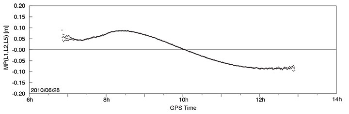
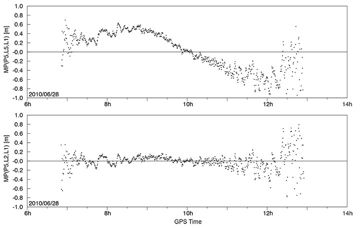
    A long pass of L1, L2, and L5 code and phase measurements from the new Block IIF satellite was recorded by the O’Higgins station of the CONGO network shortly after the activation of the L5 signal generator on June 28. The SVN62 satellite was tracked for more than 6 hours and achieved a peak elevation angle of more than 75° on this date.

    Figure 1 shows the resulting multipath combination computed from carrier-phase measurements of L1 C/A-code tracking, semi-codeless L2 P(Y) tracking (rather than L2C), and L5 I/Q tracking. The data have been leveled to a zero mean over the entire pass to remove the impact of the unknown carrier-phase ambiguities. Except at low elevation angles, near rise and set of the satellite where signal strengths are low, the tri-carrier combination shows a very low noise level that is consistent with the expected carrier-phase noise on all three frequencies. However, a pronounced long-term variation with a peak-to-peak amplitude of almost 20 centimeters may be recognized, which certainly comes as a big surprise and cannot be explained by local multipath. Frequency-dependent differences of the effective phase centers of the receiving or transmitting antennas can likewise be excluded, since these would result in a purely elevation-angle-dependent variation.

    FIGURE 1. Triple-frequency (M=0.142·L1-0.767·L2+0.626·L5) carrier-phase multipath combination for SVN62/PRN25 tracking from the OHIX0 station on June 28.
    FIGURE 1. Triple-frequency (M=0.142·L1-0.767·L2+0.626·L5) carrier-phase multipath combination for SVN62/PRN25 tracking from the OHIX0 station on June 28.

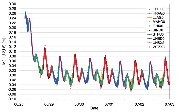
    Looking at the entire set of measurements from all available CONGO stations, we could rapidly recognize that the variation of the tri-carrier combination with time is essentially the same for all stations with a common visibility of the SVN62 space vehicle, irrespective of the employed receiver and antenna. This suggests the presence of time-varying inter-frequency biases in the L1, L2, and L5 carriers transmitted by SVN62.

    Thanks to the global distribution of the CONGO stations, the SVN62 space vehicle is always tracked by one or more stations, which enables a continuous monitoring of the L1/L2/L5 carrier-phase consistency. By adjusting the unknown offset of the tri-carrier combination for individual tracking arcs in such a way as to obtain a best match of consecutive and overlapping arcs, the variation can be traced over multiple days as shown in Figure 2. The graph shows a distinct orbital (that is, 12-hour) periodicity with a superimposed twice-per-revolution harmonic. In addition, a pronounced drift can be recognized for up to one day after activation of the L5 signal generator. Both observations suggest a temperature-dependent line bias in one or more carriers as a likely cause of the observed variation in the tri-carrier combination. (A line bias is a circuitry delay common in all observed satellites and is usually absorbed in the estimated clock offset.) However, an independent analysis of SVN62 temperature data from the onboard telemetry will be required to confirm the validity of this assumption. The space vehicle is in a deep eclipse orbit right now and therefore experiences substantial changes in its thermal conditions. However, the extreme points of the carrier-phase variation in Figure 2 are slightly shifted with respect to the local space vehicle noon (at 01:30 and 13:30 UTC) and the eclipse intervals (07:00–08:00 and 19:00–20:00 UTC).

    FIGURE 2. Triple-frequency carrier-phase combination (M=0.142·L1-0.767·L2+0.626·L5) for the first five days of L5 activation on SVN62. The curve has arbitrarily been shifted to obtain a near-zero mean during the final days of the entire arc.
    FIGURE 2. Triple-frequency carrier-phase combination (M=0.142·L1-0.767·L2+0.626·L5) for the first five days of L5 activation on SVN62. The curve has arbitrarily been shifted to obtain a near-zero mean during the final days of the entire arc.

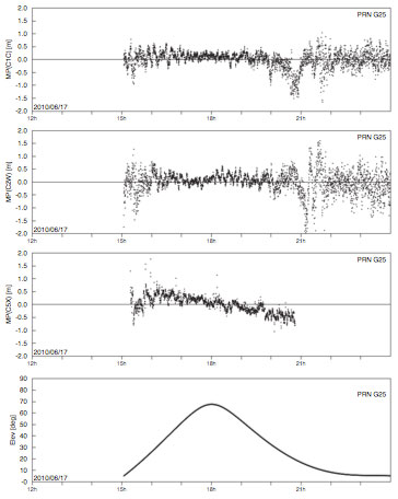
    While the tri-carrier combination provides a very sensitive measurement for the analysis of differential delays between the individual carriers, it does not allow us to uniquely attribute the observed variations to one of the three signals. We therefore made use of code measurements (pseudoranges) to further investigate the consistency of specific sets of measurements. Since the observed variation of the tri-carrier combination exhibits an amplitude comparable to the noise level of the code measurements, a suitably chosen code-carrier combination can indeed help to identify which signal or signals are affected by line-bias variations. To this end, we consider a generalized form

    E6

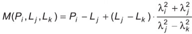
    of the well-known code-multipath combination, in which we difference the code measurement Pi at frequency i with an ionosphere-corrected combination of carrier-phase ranges Lj and Lk at frequencies j and k. In so doing, we remove geometric contributions along with clock and atmospheric variations, leaving primarily code multipath, receiver noise, and any signal perturbation that is not coherent on the involved frequencies. In the traditional case of dual-frequency tracking, the frequency of one of the involved carrier-phase measurements is necessarily identical to that of the code measurements. With triple-frequency tracking, in contrast, we are free to consider a larger variety of combinations. For the analysis of the SVN62 signals, we have specifically evaluated the L5 code-multipath combination using (a) the L5 and L1 carrier phases

    E7

    and (b) the L2 and L1 carrier-phase measurements

    E8

    The results shown in FIGURE 3 reveal a dramatic difference, which clearly hints at the L5 carrier as the main source of the observed carrier-phase variations.

    FIGURE 3. L5 code-multipath combination formed with L1/L5 carrier-phase measurements (top) and with L1/L2 carrier-phase measurements (bottom). The figure is based on SVN62 tracking from the O’Higgins station and covers the same arc as considered in FIGURE 1.
    FIGURE 3. L5 code-multipath combination formed with L1/L5 carrier-phase measurements (top) and with L1/L2 carrier-phase measurements (bottom). The figure is based on SVN62 tracking from the O’Higgins station and covers the same arc as considered in FIGURE 1.

    In the first case, a variation close to that of Figure 1 is obtained, albeit with a 5–6 times larger amplitude that reflects the different weighting of the L5 carrier phase in the corresponding measurement combinations. A good consistency, in contrast, is obtained for the L5 code measurements when differenced against the ionosphere-corrected combination of L1 and L2 carrier-phase measurements.

    Overall, we may conclude that the L5 carrier of the SVN62 space vehicle exhibits quasi-periodic line-bias variations with an amplitude of about 10 centimeters in relation to the L1 and L2 carriers. The L5 code measurements, in contrast, appear to be consistent with both the code and phase measurements on L1 and L2 at the respective noise levels. Further observations at a later time will be required to see whether the observed amplitude of the L5 phase variation is specific to the current eclipse orbit and whether it will possibly become lower when a higher angle of the Sun with respect to the orbital plane (the so-called beta-angle) is achieved.

    What are the possible consequences of the L5 phase-bias variations for users of the new L5 signal? Evidently, new positioning services building on the L5 code measurements (and possible combinations) will not at all be affected! Even in the case of carrier-phase smoothing, the smoothing time scale will be much shorter than the periodicity of the carrier-phase bias variation. The L5 code measurement quality itself is well within the system specification and no concerns exist that would prevent the satellite from soon being declared healthy.

    With respect to carrier-phase-based positioning applications, it is important to note that the L5 line bias acts like an additional frequency-specific satellite-clock offset. This has, for example, been confirmed in preliminary tests of SVN62 orbit determination conducted by the Technische Universität München. Orbit solutions using L1 and L5 measurements from the CONGO network differed by typically 15 centimeters (3D root-mean-square error) from reference orbits obtained by the Center for Orbit Determination in Europe analysis center using the IGS L1/L2 receiver network. At the same time, however, the L1/L5-based clock solutions showed a periodic offset from the L1/L2-based values that reflects the same variations as the tri-carrier combination discussed above.

    As a common error for all receivers, the L5 line bias fully cancels in differential processing. Care must be taken though, that satellite clock offsets derived from L1/L2 carrier-phase observations cannot be employed for precise point positioning using L1/L5 measurements without explicit consideration of the inter-frequency carrier-phase bias. Likewise, efforts to correct second order ionospheric effects through the use of triple-frequency measurements are likely to suffer from an imperfect knowledge of the L5 bias and its variation with time.

    Whereas some of the proposed ideas for triple-frequency processing may be difficult to materialize at present, a better characterization of the SVN62 L5 signal will certainly help to exploit the available benefits of the new signal and to establish refined processing schemes for scientific and other demanding applications. A continued monitoring of the L5 line bias and its variation with time is therefore deemed necessary and should be supported by a large number of suitably equipped tri-band GNSS monitoring stations.

    — Oliver Montenbruck, Andre Hauschild (DLR/German Space Operations Center),
    Peter Steigenberger (Technische Universität München)
    Richard B. Langley (University of New Brunswick)

    Acknowledgment

    The authors are grateful to Tom Stansell and Col. David Goldstein from the GPS Wing for early discussions and their independent assessment and interpretation of the SVN62 triple-frequency carrier-phase data.

    Equipment

    The CONGO network makes use of Javad Triumph Delta-G2T/G3TH and Leica GRX1200+GNSS GNSS receivers for tracking GPS signals on the L1, L2, and L5 frequencies. The stations are equipped with Trimble Zephyr Geodetic II or Leica AX1203+GNSS and AR25R3 antennas.

    Further Reading

    “The WAAS L5 Signal: An Assessment of Its Behavior and Potential End Use,” by H. Rho and R.B. Langley in GPS World, Vol. 20, No. 5, May 2009, pp. 42–50.

    “Using Multi-Frequency for GPS Positioning and Receiver Autonomous Integrity Monitoring” by Y.-H. Tsai, F.-R. Chang, W.-C. Yang, and C.-L. Ma in Proceedings of the 2004 IEEE International Conference on Control Applications, Taipei, Taiwan, September 2–4, 2004, pp. 205–210.

    “Triple Frequency Ambiguity Resolution Using GPS/Galileo” by O. Julien, M.E. Cannon, P. Alves, and G. Lachapelle in European Journal of Navigation, Vol. 2, No. 2, May 2004, pp. 51–57.

    “Three’s the Charm — Triple Frequency Combinations in Future GNSS” by A. Simsky in Inside GNSS, Vol. 1, No. 5, July/August 2006, pp. 38–41.

    “Total Electron Content Monitoring Using Triple Frequency GNSS Data: A Three-Step Approach” by J. Spits and R. Warnant in Journal of Atmospheric and Solar-Terrestrial Physics, Vo. 70, No. 15, December 2008, pp. 1885–1893, doi:10.1016/j.jastp.2008.03.007.


  • The System: An L5 Surprise

    It has long been accepted that we may reasonably expect any new technical device to have some growing pains. If you examine the history of the space program you will discover evidence of this. In the case of the first GPS IIF vehicle on orbit we do not have a 12,552-mile screwdriver. but we do have dedicated software and systems engineers at Boeing and in the U.S. Air Force that will solve the issues that crop up and eventually present the world with a stable PNT platform.

    I bring this to your attention because researchers at the German Aerospace Center (DLR) say they have found a small variance in the L5 signal on IIF-1. The signal variation results in no more than a 5-centimeter error with a predictable periodicity of about six hours. While observing the IIF, DLR also reports that the signal appears to be “hot” or stronger than anticipated or advertised by about 1/2 db.

    Initial reaction from the GPS Wing and Air Force experts at Schriever AFB is that the signal fluctuation appears to be temperature-related, as the periodicity correlates directly to the temperature extremes the satellite is experiencing at this time of year in its MEO orbit. It is being investigated as a matter of course during the standard checkout of the satellite, which will continue for about another four weeks according to the original checkout schedule.

    The GPS Wing is confident that all the IIF signal specifications will be met by the time the satellite is set healthy in about a month’s time and they will be able to move forward with the IIF launch schedule as planned. Obviously this could be perturbated by having to make corrections or adjustments to the satellites still to be launched, but this is normal procedure, and some leeway to correct anomalies is built into the schedule for the first few launches of any new satellite system.

    Privately, one official commented, “It turns out that no one has ever made this measurement before. The Galileo SVs can only broadcast from 2 transmitters at a time so they are combining two E5 signals generated from the same transmitter.  Furthermore, their data was collected during max Beta meaning when they weren’t in eclipse (less thermal variance).”

    The press release from the GPS Wing reads as follows.

    SMC Update. July 19 — “Officials from the Air Force Space Command, Space and Missile Systems Center’s Global Positioning Systems Wing announced the “on-orbit checkout” of the first IIF satellite is progressing as scheduled. “Nearing the half way point of its 90-day checkout period, GPS IIF SV-1 also known as SVN 62/PRN 25, is currently broadcasting the same L1 and L2 signals as previous GPS satellites and the new safety of life signal known as L5. All three signals being broadcast from SVN 62 are set unhealthy while experts monitor the quality and characteristics of the signals and the performance of the satellite.

    “During the initial phase of testing, [DLR] combined L1, L2, and L5 signals in a technique used to characterize a number of known and modeled error sources from the signals. This three-frequency combining technique helps isolate “other” sources of location error, such as multi-path (when more than one path exists for signals to travel before reception), receiver errors, satellite induced errors and unmodeled phenomena. The L1, L2 and L5 signals from SVN-62 are operating nominally but DLR noticed higher residual errors than expected compared to previous somewhat similar measurements from Galileo’s GIOVE-A R&D satellite.

    “The GPS Wing at Los Angeles Air Force Base has corroborated DLR’s results and is investigating root cause to share a deeper understanding of this new signal’s behavior with the user community. The causes of the phase variation are still being investigated, but they are likely the result of sensitivities to changes in the satellite’s thermal environment. SVN 62/PRN 25 is currently experiencing periods of both sunlight and total darkness (known as eclipse season) as the satellite orbits the Earth and traverses through Earth’s shadow. Tests to characterize the satellite’s performance during continuous sunlight exposure will continue after the current eclipse season ends later this month.

    “Typical GPS receivers using stand-alone (single signal – L1, L2 or L5) or combinations of L1, L2 and L5 signals as part of their navigation solution will not be affected by this small phenomenon. The Air Force is committed to maintaining excellence in GPS navigation and timing services and to working with the user community to best use and exploit the new modernized GPS signals.

    “When tests of this new generation of GPS satellites have been completed and Air Force leadership gives approval, the satellite signals will be set healthy and will operate as specified in the Interface Control Documents (ICDs).”

  • The System: GPS L5, the Real Stuff

    The System: GPS L5, the Real Stuff

    By Oliver Montenbruck, Andre Hauschild (DLR/GSOC), Stefan Erker, Michael Meurer (DLR/IKN), Richard B. Langley (UNB), and Peter Steigenberger (TUM)

    The L5 signal of the new Block IIF satellite shows a very favorable signal strength (Fig. 1), which is somewhere in between the L1 and L2C signal strength for the employed antenna and slightly higher than that of the GIOVE-A/B satellites. While the L5 test signal of the second-last Block IIR-M satellite (PRN1/SVN49) is transmitted through a narrow beam antenna and shows a steep variation with elevation angle, the new satellite exhibits an almost constant flux irrespective of the boresight angle.

    Following the successful launch of the first Block-IIF GPS satellite (PRN25/SVN62) on May 28, 2010 (UTC), and the activation of the legacy signals on June 6, users around the world have eagerly awaited the first transmission of PRN25 signals in the L5 band.

    In June, at last, the L5 payload was activated for more than five hours transmitting nominal signals with the PRN25 ranging code. This enabled standard tracking receivers to collect the first real L5 measurements from the new satellite.

    Scientists of the German Aerospace Center (DLR), the University of New Brunswick (UNB), and the Technische Universität München (TUM) spotted the first L5 data at 15:17:11 UTC from a station in Fredericton, Canada, followed a second later by stations in Japan, Singapore, the Canary Islands, and Germany. The stations are part of the CONGO network, which is the first global network of tri-band (L1/E1, L2, L5/E5a) GNSS receivers monitoring the GPS, GLONASS, GIOVE, and SBAS satellites. For background on the CONGO network, see the September 2009 GPS World article.

    Fig.1 Carrier-to-noise-density ratio of GPS (left) and GIOVE-A/B signals measured at the Wettzell station on June 17, 2010. Red curves refer to signals in the L5/E5a band and include data from the PRN1 test satellite and the new PRN25 satellite.
    Fig.1 Carrier-to-noise-density ratio of GPS (left) and GIOVE-A/B signals measured at the Wettzell station on June 17, 2010. Red curves refer to signals in the L5/E5a band and include data from the PRN1 test satellite and the new PRN25 satellite.

    The L5 signal of the new Block IIF satellite shows a very favourable signal strength (Fig. 1), which is somewhere in between the L1 and L2C signal strength for the employed antenna and slightly higher than that of the GIOVE-A/B satellites. While the L5 test signal of the second-last Block IIR-M satellite (PRN1/SVN49) is transmitted through a narrow beam antenna and shows a steep variation with elevation angle, the new satellite exhibits an almost constant flux irrespective of the boresight angle.

    Fig. 2 Multipath plots of L1 C/A code, semi-codeless L2 P(Y) code, and L5 code tracking for the Singapore station of the CONGO network (10-second smoothing).
    Fig. 2 Multipath plots of L1 C/A code, semi-codeless L2 P(Y) code, and L5 code tracking for the Singapore station of the CONGO network (10-second smoothing).

    While the new Block IIF satellite has not yet been set healthy and made available for public use, the early measurements collected on June 17 already demonstrate good tracking quality. This is illustrated in Fig. 2, showing the so-called multipath combination for pseudorange measurements from L1 and L2 legacy signals (the upper two panels) as well as the new L5 signal for Singapore, which had continuous visibility of PRN25 during the period of interest. Except for low elevation angles that are affected by strong multipath from structures in the vicinity of the antenna, root-mean-square tracking errors well below 30 centimeters were obtained for all signals.

    Fig. 3 L5 spectrum of PRN25 collected on June 17, 2010 with a 30-meter high-gain antenna at Weilheim, Germany.
    Fig. 3 L5 spectrum of PRN25 collected on June 17, 2010 with a 30-meter high-gain antenna at Weilheim, Germany.

    In addition, the GNSS signal monitoring facility at DLR’s ground station in Weilheim has been used to record high-rate radio-frequency samples and spectra of the new signal, a snapshot of which is shown in Fig. 3. The raw sampling also confirmed that the L5 signal of PRN25 comprises both in-phase and quadrature modulation (in contrast to the PRN1 test signal, which contains a Q-component, only).

    To the regret of U.S. scientists, the first publically traced L5 signals were only transmitted when the satellite was over Europe and Asia (see Fig. 4). Nevertheless, the test transmission provided an excellent sneak preview of what we can expect when the regular transmission starts. The satellite is presently expected to be set healthy and to start regular service by the end of August at the latest.

    Fig. 4. The ground track of PRN25 during the transmission of L5 signals on June 17, 2010. Also indicated is the footprint of the satellite showing the 0°, 30°, and 60° elevation angle contours at the beginning of the transmission. The ground track is almost centered over Diego Garcia, one of the GPS monitoring stations.
    Fig. 4. The ground track of PRN25 during the transmission of L5 signals on June 17, 2010. Also indicated is the footprint of the satellite showing the 0°, 30°, and 60° elevation angle contours at the beginning of the transmission. The ground track is almost centered over Diego Garcia, one of the GPS monitoring stations.

    Equipment. The CONGO network stations use JAVAD GNSS Triumph Delta-G2T/G3TH receivers. A Leica AR25R3 chokering antenna is used at Wettzell, while the Singapore station is equipped with a Leica AX1203+ GNSS antenna. The L5 spectrum was recorded with an Agilent PSA E4443A vector signal analyzer.

    Beidou G3

    China launched another Beidou/ Compass satellite, named G3, on June 2. By June 9, its apogee kick motor had placed the satellite in geostationary orbit at 84°38’ east, according to NORAD tracking reports.This is close to the position initially occupied by G2 (83°30’) before it started drifting. By June 9, G2 had drifted to 64°29’. By June 11, G3 had started transmitting signals on three frequencies.

    China now has two properly functioning geostationary satellites in its second-generation system, out of a total of five it expects to place by 2012 for a regional operating system; also needed for this concept are four mid-Earth orbit satellites (one currently aloft), and five inclined geosynchronous orbit satellites (zero in orbit now). A planned global system would require 5, 27, and 3 satellites in GEO, MEO, and IGO orbits, respectively, by 2020.

    Current regional-system signals on three frequencies use quadrature phase shift keying. Global-system signals will be binary offset carrier waveforms.

    Opinions on SVN-49

    The public comment period on proposed mitigation options for GPS satellite IIR-20M (SVN-49) ended May 28, and comments are viewable at www.regulations.gov under RITA Docket 2010–0002. Among others, the U.S. GPS Industry Council, NovAtel, Garmin, Septentrio, Raytheon, Boeing Commercial Airplanes division, General Motors OnStar, the European Commission, the MITRE Corporation, STMicroelectronics, the German Space Operations Center, and Cessna Aircraft have all filed comments expressing a preference for one option or another.

    Unfortunately for the U.S. Air Force and the GPS Wing, no clear consensus emerges. Indeed, differences of opinion naturally follow the respective orientation of each company or organization toward their customers’ or members’ specialized needs.

    Devote It to Science. Perhaps in recognition of this imbroglio, at the Air Force Space Command- Industry Exchange on June 15, Lt. Colonel Todd Parks briefed the PNT Functional Capability Team, explaining that the Air Force now was soliciting from industry “innovative applications” for the SVN-49 signal in space.This echoes a suggestion by Javad Ashjaee at last year’s unprecedented ION/ USAF session on SVN-49, where he proposed that the signal be used for studying multipath.

    A website article at env-gpsworld-integration.kinsta.cloud/49opinions recaps commentary and preferred options from several companies and organizations.

    The potential mitigations are each designed to reduce the impact of the unique nature — that is, errors — of the SVN-49 signal to a portion of the user segment. They are (so far):
    1. Set healthy with current 152- meter antenna phase center (APC) and associated clock offsets.
    2. Set healthy with factory APC offset.
    3. Users switch to multipath-resistant receivers.
    4. Modify receiver software to use look-up table corrections.
    5. Increase user range accuracy (URA) index to a minimum value of 3.
    6. Remove data modulation from L2 P(Y)-code, and
    7. Change L2C PRN code to a “unique sequence.” (6 and 7 are considered a pair, to be jointly implemented for desired effect.)
    8. Change SVN-49 from PRN-01 to PRN-32.
    9. Use spare health code so future users could use SVN-49 despite unhealthy setting. For background on the SVN-49 situation, see Richard Langley’s Expert Advice column from August 2009. Briefly, the pseudorange data broadcast by the satellite contains larger than normal errors that vary according to the elevation of the satellite above the horizon.

    The comments filed by the U.S. GPS Industry Council (USGIC), available as a PDF file at both URLs listed in this story, are the most detailed and extensive across all the options. However, the stated preference of the USGIC for Option 9 does not necessarily reflect agreement across all sectors of industry. As the USGIC points out, “Options 1 through 8 propose to designate SVN 49 as healthy using techniques that enable mitigation for some user applications, but that are unable to also mitigate adverse impacts to otherusers.”


  • The System: First IIF Satellite Speeds into Orbit


    At press time, GPS spacecraft IIF-1 was set to be launched May 27 from Cape Canaveral Air Force Station in Florida. This first of a new generation of satellites will travel quickly — instead of taking several days to reach its orbital slot, the new satellite should make the journey in three-and-a-half hours.

    The new IIFs will broadcast the operational civil L5 signal, intended for safety-of-life applications. It will be compatible with Galileo, GLONASS, and QZSS, with the goal to be interoperable as well. L5 will transmit at a higher power than current civil GPS signals, with wider bandwidth and lower frequency that may enhance indoor reception.

    IIF-1 caught its breathless ride aboard a Delta 4 rocket from the United Launch Alliance, a joint venture of Lockheed Martin and Boeing, formed in late 2006.

    Earlier GPS satellites rode on smaller Delta 2 rockets that, although reliable, did not possess the oomph to place space vehicles directly into the orbiting constellation, 11,000 miles high. Delta 2s put satellites into highly elliptical orbits looping from as low as 100 miles above Earth at perigee to the 11,000-mile apogee. At a strategic point, a solid-fuel kick motor attached to the satellites pushed them into position for circular orbit on high.

    The more powerful Delta 4 will shoot the IIFs directly into their destination slots. Future IIF launches may also use similarly equipped Atlas 5 rockets. The next IIF satellite, GPS IIF-2, could rise aboard an Atlas 5 as early as November.

    The IIF generation, manufactured by Boeing for the U.S. Air Force, is designed not only to broadcast the new civil L5 signal, but have a longer design life of 12 years and faster processors with more memory. “These next-generation satellites provide improved accuracy through advanced atomic clocks, a more jam-resistant military signal, and a new civil signal that benefits aviation safety and search-and-rescue efforts,” said Craig Cooning, vice president and general manager, Boeing Space and Intelligence Systems.

    “GPS IIF will increase the signal power, precision, and capacity of the system, and form the core of the GPS constellation for years to come,” said Air Force Col. David Madden, GPS Wing commander.

    A total of 12 IIF satellites will make their contribution to getting the new L2C and L5 signals closer to operational capability before the GPS III generation takes over, beginning with a 2014 launch.

    As the first spacecraft in the GPS IIF series, GPS IIF-1 underwent stringent and comprehensive testing following shipment to the launch site in February. Tests included verification of key satellite functions as well as end-to-end system testing to verify operations between the satellite and the ground control segment at Schriever Air Force Base in Colorado.

    Commands were sent from Schriever to GPS IIF-1 at Cape Canaveral to turn on payloads, reprogram processors, and verify interoperability with user receivers and equipment, both civil and military.

    Launch of the satellite, originally scheduled for May 20, was delayed four times because of various technical problems.


  • The System: Galileo ICD, Free at Last

    Galileo ICD, Free at Last

    The European Commission (EC) has published an updated Galileo Open Service Signal-In-Space Interface Control Document (OS SIS ICD) giving technical specifications and performance expectations for the future system.

    As reported by GPS World in October 2009, the EC will not charge for manufacturing licenses. No fees will be required for manufacturers to design, develop, make, or sell receivers capable of using the Galileo Open Service signal. Manufacturers are required to apply for the free licenses, which “will be provided on a non-discriminatory basis in accordance with European Union rules and international commitments.”

    The SIS ICD, a 216-page, 4 MB PDF, is available.

    To obtain a license, interested parties must e-mail to [email protected], “mentioning their request for a license agreement, which is without any exclusivity or geographical limitation.”

    In a section addressing intellectual property rights (IPR), previously the stumbling block towards free-market manufacture and sale of Galileo receivers, the release states that “The information contained in the OS SIS ICD . . .  is subject to IPR. The use of [this] information . . .  including the spreading codes which are subject to IPR, is hereby allowed for research and development and/or standardisation purposes . . . “ and, in a later section regarding commercial use, “. . .  is hereby allowed for manufacturing, distribution, commercialisation, sale of electronic devices (e.g. chipsets and receivers) and supply of Value Added Services.”

    Galileo Frequency Plan.

    SBAS Woes

    In mid-April, Intelsat announced it had lost control of its Galaxy 15 satellite that hosts the WAAS SBAS transponder used by the U.S. Federal Aviation Administration (FAA). Shortly thereafter, the FAA announced that the satellite, one of two used by WAAS, would drift out of usable orbit within two to four weeks.

    Once G-15 is out of usable orbit, WAAS will be disrupted for users in northwest Alaska. The rest of the WAAS service area — U.S., Canada, Mexico — will operate normally but will be reduced to a single point of failure with one WAAS broadcasting satellite remaining (PRN 138).

    The FAA is investigating at least two alternatives:

    • Utilize Inmarsat 3 (POR) that was previously used by WAAS before switching to Galaxy 15 in 2006. POR is located at 178°E.
    • Accelerate the testing of Inmarsat 4-F3 (PRN 133). Testing is already in progress and due to be complete in December 2010. The FAA stated that there is “potential to implement as an emergency release.”

    Neither solution is an immediate one. The FAA stated that integrating POR back into operational WAAS would take 12–16 months. The quickest solution is to accelerate the implementation of PRN 133; the FAA said it might be able to shave 1–2 months from original target date.

    The FAA stated that with only a single WAAS GEO broadcasting satellite, users may experience a temporary loss of service 3-5 times this year for up to five minutes each while WAAS Uplink Station Switchovers occur.

    GAGAN Tumbles.  A rocket carrying a satellite-based augmentation system (SBAS) satellite crashed into the Bay of Bengal, deaing a significant blow to India’s GPS-Aided Geo Augmented Navigation (GAGAN) program. The rocket was to deliver the two-ton GSAT-4, which hosted, among other things, an L-band transponder that was to broadcast GPS navigation corrections used by civil aviation and other transportation modes. GAGAN, a program that is years into development, is similar to and compatible with the U.S. WAAS, Europe’s EGNOS, and Japan’s MSAS, designed for next-generation international aviation navigation.

    The initiative was using an Indian-designed and -built cryogenic engine on a rocket for the first time. The Hindu News website reported that “India began developing the cryogenic engine as its answer to technology denial regime as the U.S. not only refused the technology but also put pressure on Russia to backtrack on its commitment to New Delhi.”

  • The System: Vistas from the Summit

    “This is an event where one gets one’s goals for the next year.” Paul Verhoef, program director for satellite navigation programs of the European Commission, may have exaggerated for effect, and for the benefit of his audience and hosts at the Munich Satellite Navigation Summit in March. But not by much.

    The conference, now in its eighth year, has assumed increasing importance on the international circuit of GNSS policymakers and communicators. Although with a decidedly European bent, it draws representatives from most if not all systems to mingle and present. A 16-member delegation from China’s Compass system furnished one of the liveliest topics of conversation — and speculation.

    “When we started in 2003, there were many technical conferences on the one side, and we saw a niche for the institutional and political side of satellite navigation,” said Berned Eissfeller of the Institute of Geodesy and Navigation, German Federal Armed Forces University, conference director and host. You can watch video clips of Eissfeller and other speakers.

    GNSS came in for a check-up, a sort of self-examination this time. The 2009 conference was titled “The GNSS Race,” but this year it was “GNSS — Quo Vadis?” The Latin phrase means “Where are you going?” Following program updates, sessions focused on safety-of-life, compatibility, legal/intellectual property, and privacy issues.

    Galileo. Paul Verhoef continued his remarks that open this story. “I have been given [my goal]: Galileo must succeed.

    “You know the world today is not what it was a year ago. It means obviously the financial crisis has had an impact on our economies, on public finance, and therefore I would not be surprised it may leave its mark on satellite navigation. The reason is simple: the systems that are either operating or being deployed are being publicly financed. Galileo is the only system that is financed from a purely civilian budget. All the systems need more than ever to demonstrate their public utility.

    “I put it to you that this is an opportunity. As we’ve already heard, there is much to be gained in this market. After the PC, mobile communications, and Internet, satellite navigation is the next breakthrough technology. There are enormous revenues foreseen and already present in this market. There are many jobs possible for those who want to get it, and we think from the European side we have an enormous chance of capitalizing on this among other things by investing in this technology. Therefore, Galileo- and EGNOS-based innovation is certainly politically of interest.

    “Obviously, it is not a path of roses. There will no doubt be many more critical questions during these days. However, from our side, we have set our goals. I think they are modest, but they are firm. We want to be the second system of choice. At least in the first instance, we will see where we will go after that. Obviously, this is going to cost a bit of time. I shall invite you, if you get impatient, if the public gets impatient, to look at the history of the other systems. Developing and deploying these other systems is costing time.

    “We think that Galileo will meet its deadlines. I think one of the important messages this year, and you have seen it, we are putting things in place. There are contracts in place, there are satellites on order, there are launches on order, there are installations being built — Oberpfaffenhoffen, Fucino, there are others around the world — EGNOS is operational, we’re going to declare the safety-of-life of EGNOS later this year. So we are really moving forward at good speed at the moment.

    “We need to win the hearts of the users, the application providers, and the service providers. At the downstream market is the real challenge for these systems. We need to help do that. We are addressing this among other things by providing a more and more reliable schedule for availability of Galileo and EGNOS services.”

    Galileo ICD Soon. “We are about to publish in the next couple of weeks the so-called signal-in-space Open Service interface control document, which I know a number of you have waited for a long time.

    “We need also to move forward at a political level. In this case, no GNSS system can be credible if it is not backed by a long-term political commitment particularly by its owner. So after the decision of the Parliament and the Council to deploy the system, these two institutions are now clearly called upon to provide us such political long-term commitment that is credible in the eyes of the users.”

    GPS. Anthony Russo, director of the U.S. National Space-Based PNT Coordination Office, said “Keeping cards close to the chest in a competitive situation can well become a liability, creating a future need for a re-work or undoing if you paint yourself into a technological corner.” This appeared to refer to China and its Compass system; information has been singularly difficult to obtain on almost every aspect of this budding constellation.

    Regarding the April 2009 U.S. General Accountability Office report that forecast gaps in constellation availability, Russo stated, “The GAO will revise its report somewhat. They were using a model that was a little too cautious, one used by the [GPS] Wing. But satellites on orbit have been performing past estimated life. Further, we can turn off secondary payloads to conserve energy onboard satellites [and thus extend life] if needed.”

    The next morning, Lt. Col. Liz Roper, Air Force Space Command, gave a status and modernization briefing; the most eagerly awaited development is the launch of the first Block II-F satellite, scheduled for some time in May. She alluded to “a few setbacks” from the August 2009 launch of SVN49 with its well-documented signal problems, but emphasized the episode’s “positive aspects: the relationships we’ve been able to build in seeking solutions to that situation.”

    GLONASS. Grigoriy Stupak, deputy general director and general designer on GLONASS systems, briefed the audience in fluent Russian. For a recent launch update, see story below.


    Compass. Two of the Chinese delegates spoke in the opening session. Jiao Wenhai from China Satellite Navigation Office did elaborate the basic principles of the Beidou (Compass) system:

    • openness (“China will widely and thoroughly communicate with other countries on satellite navigation issues.”)
    • independence
    • compatibility (“China will pursue solutions to realize compatibility and interoperability with other satellite navigation systems.”)
    • gradualness.

    He promised an English-language version of the governmental website www.beidou.gov.cn or www.compass.gov.cn “soon.” Wenhai recapped:

    • the frequencies Compass will use: 1561.098, 1207.14, and 1268.52 Mhz in Phase II until 2012; and 1575.42, 1191.795, and 1268.52 in Phase III by 2020.
    • the general development plan: five geosynchronous, five inclined geosynchronous, and four mid-Earth orbit satellites providing a Chinese regional service using mainly Compass Phase II signals; then development of a global service broadcasting mainly Compass Phase III signals from five GEO, three IGSO, and 27 MEO satellites.

    The Chinese speakers displayed a certain disingenuousness in giving verbally and in their slides the location of the January launch, Beidou G1 geostationary satellite, as 160 degrees East, somewhere over the open Pacific. When GPS World pointed out that NORAD satellite tracking shows G1 has been repositioned to a slot at 144.5 degrees East longitude, they huddled for several minutes before stating that yes, it had moved to that position and was undergoing in-orbit testing. That spot was previously occupied by Beidou 1D, apparently decommisioned about a year ago due to power problems. 1D currently orbits in graveyard above geostationary altitude.

    A personage civilly associated with the U.S. Air Force confirmed the actual G1 location to the magazine, and could only speculate that it was more advantageous to Chinese ground control for monitoring and testing. As to why spokespersons misstated the location, that remains inscrutable.

    GLONASS Back in Black

    Three GLONASS-M satellites launched on March 1 are expected to enter service on March 22 and March 30, according to deputy general director Grigoriy Stupak’s statement in Munich. This would bring the constellation, according to his calculations, to 23 operational satellites, though two of those are held in reserve.

    With 21 satellites broadcasting signals, the system claim 98.5 percent global availability. Block 42 (three more satellites) has an August 2010 launch date, and Block 43 one for November 2010. By December, Stupak predicted 24 active satellites on orbit, for 99.5 percent global availability.

    The GLONASS-M satellites have a stated seven-year lifetime. CDMA signals will begin with next-generation GLONASS-K satellites, while FDMA signals continue in parallel. The Russians plan to “reach 5-meter accuracy by 2017, almost equal to accuracy of other GNSS,” and are “paying more attention to differential corrections for integrity monitoring.”

    ICG Questions

    The International Committee on GNSS (ICG) Working Group on Compatibility and Interoperability invites GPS industry members to fill out a questionnaire, provided online in two formats: as a downloadable MS Word document or a PDF.

    The Industry and User Community Questionnaire is designed to obtain worldwide input from industry, academic institutions, and other representatives of the GNSS user community with technical expertise regarding GNSS signals and other system characteristics that aid or hinder the combined use of the signals in applications, equipment, or services. For instance, respondents are asked to grade certain signal characteristics as to their importance in overall interoperability considerations for a particular type of application.

    Respondents are asked to e-mail completed questionnaires to the ICG by May 28.

    To download instructions and the form, go to env-gpsworld-integration.kinsta.cloud/icg.

  • The System: New Kid on the Block: IIF Readied

    The System: New Kid on the Block: IIF Readied

    New Kid on the Block: IIF Readied

    The first Block IIF satellite destined for orbit arrived at the Navstar Processing Facility at Cape Canaveral, Florida, aboard an Air Force C-17 cargo aircraft on February 12. It is now undergoing preparations for its launch this spring on a Delta IV rocket. Block IIF will enhance GPS performance by reportedly providing twice the navigational accuracy of heritage satellites, more robust signals for commercial aviation and search-and-rescue, and greater resistance to jamming in hostile environments.

    New L5 Signal. The new IIFs will broadcast the operational civil L5 signal, whose spectrum allocation was secured by broadcast of the signal by a IIR(M) satellite last year. L5, at 1176.45 MHz, lies in the Aeronautical Radionavigation Services band and can be used for safety-of-life aviation. It will be compatible with Galileo, GLONASS, and QZSS, with the goal to be interoperable as well. L5 will transmit at a higher power than current civil GPS signals, with wider bandwidth, and lower frequency that may enhance indoor reception.

    More L2C Beacons. The IIF generation will also add to the number of satellites on orbit that broadcast the L2C signal at 1227.6 MHz, bringing it closer to full operational capability. L2C enables the development of lower-cost, dual-frequency civil GPS receivers for correction of ionospheric time-delay errors. Once the control segment modernization is complete, enhancements such as dataless and pilot channels for improved performance and an improved navigation message with more precise clock and ephemeris information will be available. L2C will also be interoperable with the Quasi-Zenith Satellite System (QZSS) under development by Japan.

    Long Life. Built by Boeing, the IIF has a longer design life of 12 years, faster processors, and more memory. It will be followed by 11 other IIFs before modernization shifts into a higher gear with the GPS III generation.

    It takes four hefty guys to wheel the new satellite along the tarmac, but it will only take one Delta IV rocket to lift it 20,171 kilometers into space on May 13.
    It takes four hefty guys to wheel the new satellite along the tarmac, but it will only take one Delta IV rocket to lift it 20,171 kilometers into space on May 13.

    Some Receivers Run Afoul of GPS Ground Control Software Update

    On January 11, 2010, when the GPS Wing and the 2nd Space Operations Squadron (2SOPS) loaded the updated AEP 5.5C software to the ground control segment, a problem surfaced with a specific subset of GPS selective availability anti-spoofing module (SAASM) receivers.

    The GPS Wing did not revert to the previous AEP 5.4 because of the upcoming IIF-SV1 launch. The scheduled sequential AEP 5.5C and AEP 5.5D updates are required before the ground control segment can adequately manage the more advanced capabilities of the IIF satellites.

    One purpose of the 5.5C AEP update is to enable SAASM functionality in coded receivers. The software for this functionality has been resident in various certified SAASM receivers for some time, but was never implemented in the ground control segment. The update alleviates that problem for the majority of SAASM receivers, but for one manufacturer it has caused problems. The updated software sends a specific code to SAASM receivers that enables them to authenticate the message and ensure that the code is correct, and is being sent from the GPS and not some other source. For most receivers this worked without a hitch, but for one manufacturer, a software (SW) bug or glitch occurred that must be corrected before the receiver can authenticate. This fix is in progress and will most likely be implemented as a software or firmware update to the receivers.

    Timing. Another problem with a different set of receivers manifested itself exactly two weeks after the AEP 5.5C update occurred. Those that have researched this problem in some depth feel that the problem is totally unrelated to the AEP update and would have occurred regardless.
    This is also considered to be a receiver software bug for the manufacturer, and that process is ongoing.

    ICD. Prior to activating the software update, the GPS Wing issued an updateable ICD or Interface Control Document that all receiver manufacturers use as a voluntary guide to determine compliance. Strict compliance by the manufacturer with the receiver interface control document (ICD) may have prevented the first issue, but the second may be a serendipitous event of the type that occurs from time to time no matter what precautions are taken.

    The GPS Wing has issued two Notice Advisory to NAVSTAR Users (NANUs) for civilian and commercial GPS users and for military users, asking for user comments.

    Letter to the Editor. Meanwhile, a reader wrote in: “I have issues with misleading e-mails containing inaccurate titles of articles posted on the site. There have been multiple cases recently claiming AEP software (SW) upgrades caused problems with receivers. In fact, and as proven by the vendors involved and others analyzing the problems, the AEP SW did not cause any of the observed conditions. ICD noncompliance of SAASM user equipment (UE) caused the problems, and the AEP SW upgrade allowed DoD, FAA, and vendors to finally discover the noncompliance issues and begin the process to resolve them. The community should view the 5.5 SW upgrade for what it is: a valuable new capability implemented correctly, which helped us all understand some unexpected shortcomings in UE.”

    The editor concurs, and apologizes for misleading article titles. However, hard information was scant — in fact, completely unavailable — at the time.

    GLONASS Gets Regional; Beidou Moves; Galileo Inks

    The three new GLONASS-M satellites launched on December 14 have been set operational: GLONASS 730 in orbital slot 1 was set healthy on January 30, joining 734 and 733, which were set healthy earlier in the month. This brings to 18 the number of satellites currently in service, although GLONASS 722 continues to provide a healthy signal only on its L1 frequency. At present, the constellation only suffices to provide a 24-hour regional signal over Russian territory, although satellites can and frequently are pulled in by global high-precision users to complete an RTK solution, along with GPS.

    Two satellites are in maintenance mode and set unhealthy, and two others, launched in 2003 and 2005, respectively, are in the process of being decommissioned.

    The next GLONASS launch, of the GLONASS Block 40 satellites originally set to rocket up last September but returned to the Reshetnev factory with problems in the signal generator, is scheduled for March 2. Three more will rise in August, and a November 10 booster will put two GLONASS-M satellites and the first GLONASS-K satellite into orbit.

    Beidou. According to tracking data from the United States Strategic Command, Beidou’s G1 satellite has drifted from its original location of 160°E and is currently at about 147°E longitude, that is, no longer in geostationary lock. Perhaps it is moving to another assigned Beidou slot, to back up or replace one of the other satellites in the constellation, but this can be no more than speculation. Hard data on the Beidou/Compass system is extremely difficult to come by. The new Chinese government Beidou/Compass website does not provide up-to-date information on the status of the constellation — something we take for granted with GPS, GLONASS, and Galileo.

    Galileo. The European Space Agency signed contracts for Galileo’s full operational capability phase on January 26: with OHB for the manufacture of 14 satellites, delivery of the first in July 2012, followed by two satellites every three months; for launch services with Arianespace; and for system support with Thales Alenia Space.


    24+3 FAQ

    Eric_Gakstatter_125Survey editor Eric Gakstatter posed these questions to the GPS Wing; their answers follow.

    Will the satellites (SVN24, SVN26) remain healthy during their repositioning journey?

    Yes. The satellites will be set unhealthy for the initial Delta-V, but will return to healthy status approximately 24 hours after initiation of the Delta-V. Initial Delta-V for SVN24 was accomplished on 13 Jan 10 and returned healthy on 14 Jan 10. SVN24 will take up to a year to reach its final destination. Initial Delta-V for SVN49 was accomplished on 21 Jan 10 and will arrive at its expanded position in Jun 10. Initial Delta-V for SVN26 will begin early Feb 10.

    Why the two-year timeframe to realize the benefits when all repositioning will be complete in 12 months?

    The two-year timeframe is a conservative estimate which takes into account potential operational necessities which could extend the time required for completion. We must take a disciplined approach to cover possible failures and ensure continuity of coverage during the transition. We will be adding GPS IIF vehicles to the constellation and older vehicles may fail during the transition timeframe. As vehicles are added and removed, the current plan is subject to change in order to provide the best service to all civil and military users. Some of these decisions could require additional time to complete the expanded constellation. However, benefits will likely be realized well in advance of 24 months.

    What is the reasoning behind using SVN49 as a key component of the 24+3 configuration since it won’t benefit a significant portion of the civilian user community, namely aviation and marine navigation as well as other SBAS (WAAS) and DGPS users? In my understanding, the FAA’s and the Coast Guard’s user bases are primarily single-frequency pseudo-range, users who won’t be able to use SVN49.

    SVN49 was selected because it is a brand new satellite with four good clocks. Although issues with SVN49’s navigation signals may make it unusable for all civil use, it could still put out a valid set of signals for military use. The Air Force team is continuing to work “open book” with civil and industry GPS experts to determine the possible outcome of SVN49. Although SVN49 is not currently healthy, GPSW and 50th SW are actively working a mitigation that may allow setting the vehicle healthy in the future. As a mitigation in case we are unable to set SVN49 healthy, SVN30 will be rephased to the same slot following a successful launch and on-orbit checkout of IIF-1. We expect to have either SVN30 or SVN49 healthy and broadcasting from the expanded slot within a 24-month timeframe. At this time, no decisions have been made and no options have been ruled out regarding SVN49.

  • The System: New Math for GPS

    New Math for GPS: the Geometry of 27

    The U.S. Air Force GPS Wing and 50th Space Wing have begun repositioning GPS satellites in space to fly what they call the 24+3 or Expandable 24 constellation plan. The initiative will take up to 24 months to fully implement. Benefits to users will be slowly realized during that time, as the number of GPS satellites in view will increase, potentially increasing GPS receiver accuracy.

    The plan significantly alters the current configuration of 30 GPS satellites on orbit. Several newer satellites now fly in tandem, side by side, with older satellites, as a hedge against their eventual failure. This policy has effectively limited constellation geometry to that of 24 satellites.

    The policy change was driven at least in part by the desire to improve satellite visibility for U.S. and allied military operations in Afghanistan and Iraq, where mountainous terrain can hamper signal coverage for troops on the ground.

    The first GPS space vehicle (SV) to move, SVN24, began its long journey on January 13. This satellite has the farthest to travel, and will not reach in its new slot for approximately 12 months (January 2011). The two others, SVN49 and SVN26, will affect the geometry much sooner. SVN49 started its four-month journey on January 21, destined to reach its new home in May 2010. SVN26 will stir on February 8 and should also find itself in its new slot by that time, if all goes as planned.

    SVN24 will take a full 12 months because the operators must have maneuvering fuel onboard when it reaches its final orbit location for station keeping and Delta-V maneuvers; and they must conserve fuel for end-of-life in as much as 15 years to boost the satellite into a safe retired orbit.

    Civil Benefits. 24+3 will especially benefit surveyors and other professionals using real-time kinematic (RTK) positioning. These users currently require six satellites in view for a very precise (centimeter accuracy) position.

    In the last few years, some users that require long dwell times and experience high mask angles have been forced to use GLONASS satellites as an augmentation, which works, although GLONASS satellites have historically been less accurate than the GPS. When 24+3 is fully implemented, GLONASS augmentation may no longer be necessary for these users.

    New Ground Software. The GPS Wing also trumpeted the advent of improved capabilities through a new ground-system software release. These include telemetry, tracking, and commanding for the new GPS IIF space vehicle — as yet unlaunched. On-orbit capabilities planned to arrive with the IIF Block span the new L5 navigation signal for civil users, continued and more robust security-wise deployment of the encrypted military-only code known as M-Code, on-orbit crosslink (between GPS satellites) improvements, and overall signal power increases.

    In November and December 2009, the new software uploaded operational GPS IIA and IIR space vehicles with navigation data and completed normal operational functions.

    Penny-Wise, Pound-Foolish U.S. Coast Guard to Pull Loran Plug

    The U.S. Coast Guard announced on January 7 that the it will cease broadcasting the North American Loran-C signal on February 8.
    “As a result of technological advancements during the last 20 years and the emergence of the U.S. Global Positioning System, Loran-C is no longer required by the armed forces, the transportation sector, or the nation’s security interests.”

    The force, and President Barack Obama’s fiscal year 2010 budget which it cited, go against the unanimous recommendation of the Independent Assessment Team, empanelled by a previous administration and led by Bradford Parkinson, founding program director for GPS: “complete the eLoran upgrade and commit to eLoran as the national backup to GPS for 20 years.” To pay for expert advice and then ignore it is a time-honored tradition of U.S. government.

    Senator Susan Collins, ranking member of the Senate Homeland Security and Governmental Affairs Committee, called the Coast Guard plan a “mistaken decision,” adding that “A lone system is problematic and ill-advised on so many levels. We need Loran as a backup to GPS.
    “Pulling the plug on Loran now will likely prove penny-wise and pound foolish, because there is no other system, or constellation of systems, that offers a more robust and cost-effective backup to GPS than eLoran. It is my urgent request that the Secretary reconsider this ill-informed decision.”

    Galileo Satellites Awarded to OHB

    The European Commission awarded on January 7 contracts for deployment of Galileo’s initial operational capability in space. The first order of 14 satellites goes to OHB System AG of Bremen, Germany (as indicated, but not confirmed, in these pages last month).

    The EC bestowed a contract for system support services upon ThalesAleniaSpace of Italy, and one for launch services to Arianespace of France. Initial deployment and service provision of Europe’s satellite navigation system is now envisioned for early 2014.

    Procurement contracts for ground mission infrastructure, ground control infrastructure, and operations should be awarded by mid-2010.
    The OHB order carries a value of €566 million (U.S. $811 million), with delivery of the first satellite in July 2012. One satellite is expected every 1.5 months thereafter, with the last one scheduled to be delivered in March 2014.

    Compass at Three

    China launched a third Beidou-2 or Compass navigation satellite on January 17, destined for geostationary (GEO) orbit. A previous middle-Earth orbit (MEO) craft went up in April 2007 and a GEO in April 2009. By January, that GEO had drifted about 16 degrees from its initial slot, possibly indicating it is uncontrollable although some reports indicate the satellite is still usable.

    Eventually, China plans five GEOs and 30 MEOs. The initial Compass system will provide the Asia-Pacific region with navigation, timing, and short-message communication services as early as 2015, with a plan for global coverage by 2020.

    Compass will offer an open service (free positioning and timing services, positioning accuracy 10 meters, timing 10 nanoseconds), and an authorized service, with “more secure” position, velocity, timing, and communications data as well as a higher level of integrity.

    The government also unveiled an official, Chinese-language-only Compass website, www.beidou.gov.cn.


  • The System: GLONASS Heaves Three Aloft

    The Russian space agency Roscosmos launched a venerable Proton rocket carrying three GLONASS-M satellites into orbit on December 14. Each 3,000-pound satellite is designed to last seven years. They join a constellation numbering 19 satellites, although only 16 are healthy.

    Russian politicians and satnav system managers had hoped to launch six satellites between September and December, to attain a global service level, which requires 24 satellites, eight each in three orbital planes.

    However, a payload glitch found aboard one recent satellite after its launch into space forced a return to the factory of three satellites scheduled for launch in September. The three put into orbit this week will now only bolster continuing GLONASS coverage of Russian sovereign territory, which requires 18 operating spacecraft.
    The next GLONASS launch is now scheduled for a February 11–20, 2010, window.

    The Block 41 GLONASS-M satellites (Nos. 30, 33, and 34) have been placed in Plane 1, which currently has only four healthy satellites. According to Roscosmos, communication has been established with all of the satellites and performance is nominal.

    Next Up. Nikolay Testoedov, head of the Reshetnev satellite manufacturing company, said his enterprise plans to produce 17 more GLONASS-M satellites between now and 2013.
    “The preproduction flight tests of new series of GLONASS satellites, GLONASS-K, will start in 2011,” said Andrei Buravin, vice head of Russian Institute of Space Device Engineering. The preproduction flight tests of GLONASS-K will be performed together with Reshetnev company.

    It is still unclear whether the next-generation of GLONASS satellites will be launched via blocks of three satellites with Proton rockets from Baikonur, or via blocks of two satellites with Soyuz rockets from Plesetsk.

    RTCM Supports Loran

    It may be moot by the time you read this — the U.S. Coast Guard (USCG) could unplug Loran on January 4 — but the Radio Technical Commission for Maritime Services (RTCM) wrote to Secretary of Homeland Security Janet Napolitano in support of continuing and enhancing Loran service.

    The letter asserts that it cannot be accurately certified that termination of the operation of the Loran-C signal will not adversely affect the safety of maritime navigation — counter to opinion issued by the USCG Commandant. The RTCM president states that the Loran-C infrastructure is needed to complete the eLoran system to serve as a backup to the U.S. Global Positioning System (GPS).

    New Technique. Researchers have developed a technique to demonstrate a low-cost backward-compatible way to exploit eLoran to make GPS more robust. The method paves a way for the average GPS user to become a GPS+eLoran user. Go to env-gpsworld-integration.kinsta.cloud/loran for the letter and other Loran stories.

    Galileo Contract Award Imminent

    A contract award for at least eight of the in-orbit validation satellites had been promised for the end of this year by the European Commission (EC), but as this magazine goes to press on December 16, no official announcement has surfaced.

    An unconfirmed report in early December claimed that the European Commission and European Space Agency had awarded a contract for eight Galileo satellites to underdog bidder OHB Technology of Germany. However, this report was privately denied and in fact refuted by an EC representative.

    The OHB-led consortium includes small-satellite specialist Surrey Satellite Technology Ltd. of Britain, which built and continues to operate the GIOVE-A satellite, Galileo’s first launch. The competing Astrium-Thales Alenia consortium built the second Galileo satellite now in orbit, GIOVE-B.

    The report, published on December 4 on the Space News website, asserted that “the European Commission has selected OHB Technology of Germany to build at least eight Galileo navigation and positioning satellites for about 350 million euros ($525 million) in a decision that postpones any award to competitor Astrium Satellites pending further negotiations with Astrium.” Reporter Peter de Selding cites industry officials as his sources.

    An EC representative privately denied the report, asserting “it is not true.” An industry source said “It is not confirmed, we are waiting for the decision.”

    The rumor created an uproar in the German state of Bavaria, a center for that country’s aerospace industry and government-aided research. Astrium had reportedly planned to perform much of its Galileo work in that region, and the Space News story holds out the expectation that “political pressure will be applied to reverse the ruling in the coming days.” The region is already home to the Galileo Control Center at a German Aerospace Agency (DLR) site.

    Block Approach. The two consortia have been negotiating their bids on the contract with the commission and its technical adviser, the European Space Agency (ESA), for 15 months. Initially, the two European Union bodies set a contract ceiling of 840 million euros to build 28 Galileo satellites; un the past few months they revised the total order to 22 satellites and asked for bids for eight, 14, and 22 satellites. Reportedly, there are price ceilings for each of the three potential order sizes — around 400 million euros for eight satellites, 650 million euros for 14 satellites, and 840 million euros for all 22.

    Repeatedly postponed throughout its conceptual phase, the Galileo system now — officially, at least — hopes to achieve initial operational capability by 2014.

    Whether or not the Space News report is eventually substantiated, the central European government has already signaled in multiple ways its dissatisfaction with its various member states’ aerospace industry giants, whom it holds responsible for the protracted dysfunctionality of the now-abandoned public-private partnership to build Galileo. The EC has largely wrested control of the satellite award process away from its space agency, and indicated that it intends to maintain a firm grip on the purse strings.

    Application Days: Galileo Application Days are set for March 3–5, 2010, in Brussels, Belgium, with live demonstrations of cutting-edge applications developed for GNSS under the European Union’s 7th Research Framework Programme (FP7), former ESNC Competitions, the ESA Technology Transfer Programme, and national and regional initiatives. See www.application-days.eu for details.

    Opinion: GPS L2P(Y) Phase Shift Causes Needless Consternation

    Roughly three years ago, the U.S. military conducted the first flex-power test on the L2 GPS codeless signal. Almost immediately, the civilian GPS community expressed concern that future changes to the L2P(Y) signal power levels might cause a signal phase shift; such a phase shift would be incompatible with equipment using the P(Y) signals in a codeless/semicodeless fashion for extremely accurate positioning applications.

    Civilian users were naturally upset because they had invested millions of dollars in systems that might not be usable — even if the unusable periods were of a very short duration.
    The National Positioning, Navigation, and Timing (PNT) Executive Committee responded by tasking the National PNT Engineering Forum (NPEF) to look at the problem. Within a few months, the NPEF announced a solution: flex power could be used in such a manner that it would not cause a phase shift. At the same time, the military reminded civilian users that the codeless use of L2P(Y), as accurate as it might be, was never intended and should not be a long-term solution.

    An agreement was reached between the U.S. government and civilian users that the civilian users of this codeless/semicodeless technique would migrate from using the L2P(Y) carrier to using the new L2C signal to achieve not only the same, but better results. To codify this agreement, a Federal Register Notice was issued in 2008 identifying the terms of this agreement, which guaranteed the phase stability of the current L2P(Y) signal until 2020. This gives civilian users 12 years to figure out a migration plan and to obtain adequate use of the equipment they already have on hand.

    In addition, 2020 is not a drop-dead date, but a date when the use of L2P(Y) codeless signals will no longer be guaranteed, though may well still work. Who knows what PNT advancements will take place between now and then? This could very well be a moot point by then, and in my opinion should be one now.

    Problem Solved? Apparently not. A lag between the issuance of this national policy and analogous adjustments to interface specifications caused consternation within the civilian community. Misunderstandings added to this perceived impasse. Various solutions were identified to work around this looming quandary. However, given the national policy to support codeless/semicodeless use until 2020, the Air Force Space Command commitment to that policy, and the recommendations of the NPEF, these solutions seem wholly unnecessary to me.

    The U.S. government has gone well beyond what is required to insure civilian codeless and semi-codeless users are accommodated.

    For the foreseeable future, users will be able to employ L2P(Y) codeless/semicodeless techniques for very accurate position determination and will not have to worry about phase shifts disrupting their work.

    — Don Jewell, GPS World Defense PNT Contributing Editor

  • The System: Galileo Removes Manufacturing Barrier

    With final satellite construction bids pending as this magazine goes to press, the Galileo program clarified a recent round of launch postponements and announced that the European Union (EU) will rescind its requirement for a special license to manufacture and sell Galileo receivers.

    “We have an ambition to become, after GPS, the second system of choice,” stated Paul Verhoef, program manager of the EU satellite navigation programs, at the World Congress of the International Association of Institutes of Navigation (IAIN) on October 28. “In order to reach that, the user market is key. We are currently putting our hands to the last bits and pieces of the documentation [revising the previous Galileo Interface Control Document], to be published in a few weeks’ time. We will no longer require a licensing document in order to manufacture and sell devices. We had to do this bit of work to follow up on the initial [different] preparations made under the public-private partnership.”

    Contract by Christmas. The first two in-orbit validation (IOV) satellites will be launched in November 2010, and the next two in April 2011. Verhoef referred to the previous Galileo full operational capability (FOC) date of 2013. “You now know we are not going to meet that date,” said Verhoef.

    “We come to the procurement as it stands at this moment. We are procuring the capacity through six main work packages. We are on track to announce the satellite contracts before Christmas, as well as the system support contract. Perhaps the launch contract, but perhaps not until after Christmas. The other contracts are not time-critical at this point, therefore we have delayed them slightly; to be announced in first quarter 2010.

    “We have split the total of the 28 satellites we will order into two work orders. In the first, we will procure up to 22 satellites, and in the second the rest. Industry bidders are to submit their best and final offer for 8, 14, and 22 satellites. The most crucial decision in the whole procurement will then be for us to go single-source with one of them, or dual-source with both.”

    The final and “best” bids were due to the EU and ESA on November 13 from the two consortia competing to build out the constellation.The EADS Astrium-Thales Alenia Space partnership, larger of the two, has by conventional wisdom the inside track to win the contract. However, the competion, led by OHB of Germany, includes Surrey Satellite Technology Limited (SSTL) of the UK, which has the better track record in Galileo satellite manufacture to date.

    “A double supplier would mean spending extra money,” said Verhoef in his IAIN remarks, “but it would bring some risk reduction. Will it be worth the extra money we will have to pay for it? By the end of the year we hope to have the answer for that. By the end of the year we will have under contract the delivery of 22 satellites, and the launch contract. Then we will be able to give a very clear schedule on deployment.

    “There remains uncertainty on where it will end. Budget questions depend on parliament and the EC, which will drive the final aspects of the work. We live in difficult economic times, and there are some things to be determined in 2014, when the next funding cycle will begin.

    “By the end of 2013, we will have an initial constellation of 16 satellites: four IOV and 12 FOC satellites. This is targeted to provide the open service, and parts of the other services: safety of life, PRS, and commercial. Completion of these will depend on funding questions.”

    See the Satellite. An online story on Britain’s BBC News channel contains a two-minute video clip (see PHOTO) showing close-ups of the antennae and other elements of the IOV satellite under manufacture at an EADS Astrium facility in Portsmouth, United Kingdom.

    Once completed, the payload will travel to Thales Alenia Space in Rome, Italy, for attachment to the main spacecraft bus, with a propulsion system, avionics, and solar panels, and then go to the European Space Agency (ESA) port in Kourou, French Guiana. Both intial satellites are intended to rise aboard a Russian Soyuz rocket, which has had its own problems recently, with delays due to changes necessary for the ESA launch pad.

    System Updates

    GPS to Fly Without Back-Up. U.S. President Obama and Congress have removed a key back-up system for GPS. The president signed the Department of Homeland Defense appropriations bill that allows termination of Loran-C in January 2010. Loran-C and modernized eLoran could prevent national and industrial infrastructure breakdown in the event of disruptions, interference, or intentional jamming. The House of Representatives passed a Coast Guard authorization bill calling for Loran termination, in line with the DHS appropriations bill. For details see www.pnt.gov; see also “Letters” in this issue, page 13. The Coast Guard Commandant and DHS are expected to sign off almost immediately that Loran-C can be terminated. Once they sign it, Loran signals could go off the air as early as January 4, 2010.

    GLONASS Signal Misbehavior. The planned September and October launches of three new GLONASS-M satellites were scrubbed, and the traditional Christmas launch appears doubtful at best. The Russians have commissioned a special task force to investigate a problem with the signal generator aboard an orbiting satellite, detected in late August. It is not known whether the same problem affects three satellites on the ground, destined for imminent launch.

    Beidou’s Second Bird. Beidou G2, launched last April, has drifted 10 degrees from its initial geostationary orbital slot. This may mean that it is uncontrollable and has been abandoned. Such a failure — if it is one — may delay launch of new satellites to begin filling out the Chinese GNSS. As previously reported, demonstration satellite Beidou 1D is also adrift.

  • The System: Galileo Slips, EGNOS Operates

    Four Galileo in-orbit validation (IOV) satellites scheduled to launch next year have already missed their first pad date.The European version of Russia’s Soyuz rocket is now scheduled to carry the four IOV satellites into orbit in two launches in November 2010 and early 2011, as announced by European Space Agency (ESA) Director-General Jean-Jacques Dordain on October 9.

    Both launches had been set for earlier in 2010, but ESA has encountered difficulties with the satellites, built by a consortium led by Astrium Satellites and Thales Alenia Space. Introduction of Russia’s Soyuz rocket at Europe’s Guiana Space Center in French Guiana, on the north coast of South America, has also been repeatedly delayed.

    The European Union and ESA plan to select a builder for the remaining 28 satellites late this year. Final bids from 11 companies bidding for on six Galileo work packages are expected by November 11.

    Experimental Satellite Moved. In July and August, Surrey Satellite Technology Ltd (SSTL) repositioned GIOVE-A, the first Galileo test satellite, to an orbit 113 kilometers above the orbit that the operational Galileo navigation satellites will occupy.

    Since its December 2005 launch, GIOVE-A has achieved all of its mission objectives and remains in excellent condition well beyond its design life of two years, SSTL stated.

    The test satellite secured the Galileo frequency filings with the International Telecommunication Union (ITU), collected data to characterise the medium-Earth Orbit (MEO) environment, and flight-proved technologies such as highly accurate atomic clocks.

    GIOVE-A remains fully operational, and has sufficient propellant remaining for further maneuvers. A further repositioning exercise may be performed to raise the orbit higher still before GIOVE-A is finally decommissioned.

    SSTL and its new owner, OHB of Germany, jointly form one of the two consortia now bidding for the development and construction of 28 satellites for the operational Galileo service.

    EGNOS. The European Commission (EC) declared on October 1 the official start of operations by the European Geostationary Navigation Overlay Servic (EGNOS), with its Open Service available free of charge to businesses and consumers. EGNOS is Europe’s first contribution to satellite navigation and a precursor of Galileo, the global satellite navigation system in development.

    EGNOS is a satellite-based augmentation system that improves the accuracy of satellite navigation signals over Europe. The system is composed of transponders aboard three geostationary satellites hovering high above the Eastern Atlantic and the European continent, linked to a ground network of about 40 positioning stations and four control centers, all interconnected. The EGNOS ground stations receive signals sent out by GPS satellites. Information on the accuracy and reliability of these signals is relayed to users via the geostationary satellite transponders. This allows them to determine their position to within two meters in real-time, according to EC spokespersons.

    The EGNOS coverage area includes most European states and has the built-in capability to be extended to other regions, such as North Africa and European Union neighboring countries.

    The commission seeks to support new applications in sectors such as agriculture (high-precision spraying of fertilizers) and transport (for example, automatic road-tolling or pay-per-use insurance schemes). EGNOS can also support much more precise personal navigation services, both for general and specific uses, such as systems to guide blind people and to improve signal reception in urban areas.

    EGNOS will be certified for use in aviation and other safety-critical areas in compliance with the Single European Sky regulation. Through EGNOS a safety-of-life service is expected to be in place by mid 2010. This service will provide a valuable warning message informing the user within six seconds in case of a malfunction of the system. A commercial service is under test and will also be made available in 2010.

    EGNOS operations are managed by the European Satellite Services Provider, ESSP SaS, a company based in Toulouse, France, founded by seven air navigation services providers. A contract between the EC and ESSP SaS covers management of the EGNOS operations and maintenance until the end of 2013.

    The EGNOS Open Service is accessible, without service guarantee or resulting liability, to any user equipped with a GPS/SBAS compatible receiver within the EGNOS coverage area. Most receivers sold today in Europe meet that requirement. No authorization or receiver-specific certification is required.

    GLONASS Signal Generates Slip

    A planned late-September launch of a three new GLONASS-M satellites from the Baikonur space center was postponed due to a problem with signals emanating from a previously launched GLONASS-M satellites, now on orbit. Initially, a new launch date of October 29 was set by Roscosmos, the Russian space agency, but no word had yet come at press time regarding investigation of a problem with the signal generator aboard the orbiting satellite, detected in late August. The spacecraft was taken out of service on August 31.

    GPS Wiggles: SVN49, CNAV

    The GPS Wing held an extraordinary session at ION GNSS in Savannah, Georgia, September 23, frankly explaining the SVN 49 satellite’s problem and probable solutions.

    SVN49, the IIR-M) + L5 civil-signal satellite, will be set healthy in the coming months and it will be useable, the GPS Wing said. Its L1 an L2 signals contain a pseudorange error that remains within specifications for compliant GPS user equipment.

    On the ground, a receiver sees from this satellite both a direct signal and a weaker reflected signal, which looks like a multipath component. According to models, if the direct and reflected L1 signals are in phase at zenith, a standard code-correlating receiver will measure a C/A-code pseudorange that is 1.62 meters too long. The error becomes smaller as the elevation angle drops, reaching zero at an elevation angle of about 42 degrees, and then rising slightly as the elevation angle drops to zero.

    During audience input following the Savannah panel presentations, Javad Ashjaee of JAVAD GNSS proposed simply turning the satellite on as is and using it as an opportunity, given the “defined multipath” that it effectively transmits, to study multipath and other phenomena. JAVAD GNSS Triumph receivers have demonstrated the ability to remove almost all anomalies and satellite multipath from the SVN49 signal.

    An as-yet-unconfirmed report has it that U.S. Air Force representatives and others, in an informal meeting after the session, came to a provisional agreement as to the best course. However, this has not yet worked its way through channels nor been announced.

    New Message. The first test of the CNAV navigation message format to be used in the future on Block IIR-M and IIF satellites was announced at the September CGSIC meeting in Savannah, and will begin soon. A Type 0 message will be broadcast on the L2C signal by SVN49. By the end of the year, this message is to be switched on, on all IIR-M satellites. However, this initial message type will not contain useful information for end users.

    Message Type 0 consists of a 12-second, 300-bit long message including the preamble, satellite pseudorandom noise (PRN) number, message type ID (=0), GPS time of week, a sequence of alternating 1s and 0s, and a cyclic redundancy check (CRC) parity block. The GPS time of week will change every 12 seconds, as will the CRC bits.

    Penny Axelrad Honored

    Penina Axelrad, professor of aerospace engineering sciences at the University of Colorado, received the Institute of Navigation’s 2009 Kepler Award for her “contributions in the field of satellite navigation and dedication to the education of future generations of navigation engineers.”

    Axelrad has done advanced research in topics including receiver autonomous GPS integrity monitoring (RAIM), GPS bistatic radar, satellite formation flying using GPS, GPS-based orbit and satellite attitude determination, and multipath characterization, modeling, and mitigation.

    She received a Ph.D. in aeronautics and astronautics from Stanford University and S.B. and S.M. degrees from the Massachusetts Institute of Technology. She has taught for 17 years at the University of Colorado.

  • The System: Glitches and Vulnerabilities

    A range of unrelated events in September show that GPS, the world’s preeminent GNSS, remains a work in progress.

    The first in a series of deviations from normal GPS signal broadcasts during September was noted by researches at the University of New Brunswick, among others around the globe, who found that normal signals from the L1 and L2 transmitters on the GPS satellite PRN01/SVN49 were unavailable for more than two hours on the morning of September 4.

    The satellite did not transmit useful signals on L1 and L2 from about 12:00 to 14:11 UTC, as reported by International GNSS Service stations in Europe. The L5 test signal continued to be tracked by some receivers but not others.

    One possible explanation for the inability to track PRN01 is that the satellite rejected an upload and automatically went into non-standard mode, resulting in GPS receivers being unable to track the L1 and L2 signals. In other words, the L1/L2 transmitters were still on but transmitting a non-standard signal.

    “It is not known for sure what actually happened with the satellite, but perhaps it is related to the ongoing issues with the signal reflections on the satellite and that the GPS Wing was conducting further tests,” said Richard Langley, GPS World’s Innovation editor and professor at the University of New Brunswick. “Luckily, the problem was short lived.” As to why some receivers continued to track the L5 signal but others did not, Langley speculates that some receivers may need to acquire and track the L1 signal before they can track the L5 test signal.

    HDOP Warning. On September 10, the U.S. Coast Guard Navigation Center (USCG NavCen) issued a high dilution of precision (DOP) warning for certain locations in the U.S., Asia, and Oceania, reporting that GPS users might experience a temporary degradation in GPS reception in parts of the southwest and central United States from 13:02 UTC to 13:23 UTC on September 11.

    “The warning is based on a best-four satellite scenario: what the DOPs would be if we only used the best four satellites (the combination providing the lowest DOP value) of all the satellites in view at a particular location,” said Langley.

    “However, most civil receivers these days track eight or 10 or all satellites in view. I contacted the Coast Guard about this, and they did another analysis and confirmed DOP spikes for all-in-view users too. Prompted by that, I did my own analyses and found that with PRN31 out of action for the delta-V and PRN01 not yet declared healthy, only five satellites above 5 degrees elevation angle (and almost colinear in the sky) will be visible at the stated locations and times, resulting in GDOP spikes approaching 100!

    “So, in this case, the warning is for all users in the affected areas, not just receivers with only four channels.”

    Although a window stretching from 00:30 to 15:00 UTC had been allocated for the PRN31 delta-V maneuver, prompting the high DOP alert, the GPS Wing avoided any problem to users by delaying the start of the operation until 01:27 UTC and completing it in little more than one hour. The satellite was back on line by 02:37 UTC.

    Sat Moves. After 22:00 UTC September 12, system operators began transitioning satellite SVN25 (PRN25) into the broadcast almanac for all satellites. Meanwhile, they moved satellite SVN24 (PRN24) out of the almanac.

    The current GPS operation control system (OCS), known as AEP, cannot handle 32 satellites. However, the recent move gave rise to speculation that the maximum number of operable satellites has now been reduced from 31 to 30, for some reason. Apparently, the military cannot allow more than 30 space vehicles to be in active service at any one time. So when a new SV is activated, one must be deactivated. SVN24 will be placed in caretaker status, ready to be brought back on line should the situation change or the 30 SV limit be overcome.

    Recent pronouncements by GPS Wing personnel on the benefits of the next operating system, OCX, have stated that it will be able to handle many more satellites, as many as 60. This figure now appears in doubt.

    Russian Vision. Grigory Stupak and Mark Shmulevich reported Russia’s plans to restore a full GLONASS constellation of 30 space vehicles, laying out a road map leading to full interoperability with GPS. They envisaged a world orbited by 117 navigation satellites, with GLONASS operating alongside GPS, Galileo, and China’s COMPASS, supported by a further 29 augmentation satellites. That would certainly mitigate many of the vulnerabilities of GNSS due to propagation effects — but not those from interference in the frequency bands they will all share.

    Solutions Sought to GNSS Vulnerabilities

    Baska conference report by David Last

    The second conference on GNSS Vulnerabilities and Solutions, September 2–5 in Baska, Croatia, focused on GNSS vulnerability to space weather, unintentional interference, jamming, and multipath propagation.

    The conference was a joint venture by the Royal Institute of Navigation, London, and Nottingham University’s Institute of Engineering Surveying and Space Geodesy. Sixty-four delegates, mostly European, came from 21 countries.

    Nearly half the papers focused on space weather and ionospheric and tropospheric propagation, taking in long-term and short-term solar effects, scintillation, signal attenuation, tropospheric delay variations, meteorological influences, and even gravity waves. The approach of the physicists was: Understand these things and maybe you can mitigate your vulnerability to them.

    GNSS vulnerability can threaten safety-critical and mission-critical systems, including navigation in the air, maritime automatic identification systems, and the transportation of nuclear waste and other dangerous materials on land. Mitigations include EGNOS (the European WAAS) and GBAS (ground-based augmentation systems.)

    Road Tolling. An unexpectedly hot topic was the enthusiasm of European governments to deploy road-user charging schemes based largely on GNSS technology. Some say road pricing is a rare and novel case of GNSS users who are hostile to the technology and seeking to exploit its vulnerability to the maximum. To enforce charges through the legal system may require levels of integrity approaching those of aircraft instrument-approach systems.

    Suggestions for jamming defenses came mostly from Germany: Ulrich Engel and Angelika Hirrle proposed exciting new mathematical techniques to help separate GNSS signals from noise and interference, while Michael Felux sought refuge in low-cost inertial systems.

    Hank Skalski of the U.S. Department of Transportation laid out U.S. government plans to detect and track down sources of GPS jamming. The SETS (Space Event Tracking System) will deploy aircraft, vans, fixed-base units, and trained technicians.

    See Last’s report on low-cost jammers in criminal employ in Expert Advice, October 2009.

    Smartpath Approved

    The U.S. Federal Aviation Administration (FAA) has certified Honeywell’s Smartpath precision-landing system for airport installations. As this magazine went to press, neither the FAA nor the Department of Transportation had issued an official release, but industry contacts were notified in mid-September.

    The ground-based augmentation system provides aircraft with precise navigation data for CAT I approaches and landings, enabling closely spaced parallel and curved path approaches to increase airport capacity. It asserts improved navigation accuracy over instrument landing systems (ILS), using differential GPS and broadcasting both pseudorange corrections for each satellite in view as well as approach path information in a digital broadcast.

    According to Honeywell, most current-production Airbus and Boeing aircraft now carry GBAS avionics or offer it as an option. Future Smarpath upgrades include the ability for CAT III approaches.

    Arctic Passage Traversed by Merchant Ships

    Two German merchant ships traversed the Northeast Passage from South Korea, leaving in late July, to Siberia, and plan to continue their journey to Rotterdam in the Netherlands.

    A sea lane traditionally blocked by heavy ice floes or solid sheet ice, this route has opened because of to global warming. In 2007, Arve Dimmen, director of maritime safety for Norway’s Coastal Administration, told the U.S. National Space-Based Positioning, Navigation, and Timing Advisory Board that disappearing ice across the Arctic poses potential threats: 25 percent of undiscovered oil resources lie in that region, and the route could now be used by supertankers and large container ships, as it is more economical and less time-consuming.

    Precision navigation faces more challenges north of the Artic Circle, from atmospheric affects in polar regions and the low elevation of SBAS satellites at those latitudes. A June 2009 study on GNSS use in the high Arctic by Richard Langley, however, found that conventional horizontal (marine) navigation works well north of the Arctic Circle. Still, others held that “this is another reason why eLoran is so important: someone at USCG/State/Commerce needs to use this as a wake-up call!”

     
    Created from nearly 200 Envisat scenes, this Arctic mosaic reveals that the most direct route of the Northwest Passage (the orange line) across northern Canada is fully navigable. The blue line traces the Northeast Passage along the Siberian coast, which is only partially obstructed by ice; see story, page 16. Envisat advanced synthetic aperture radar mosaic produced by the Danish National Space Center.