Tag: Tim Burch

  • Datums, feet and GNSS vectors: The 2022 NGS upgrade

    Datums, feet and GNSS vectors: The 2022 NGS upgrade

    In what seems like just yesterday, GPS World published my article in the May 2017 issue of Survey Scene on the upcoming datum change by the National Geodetic Survey (NGS) in 2022.

    With the calendar pages turning rapidly and as we get closer to the witching hour of geospatial voodoo, more items have surfaced to discuss and educate ourselves on in relation to “the change.”

    Let’s delve into these topics and break each down into what the common surveying and geospatial practitioner will need to know with the advancements in coordinates, geodesy and our everyday uses.

    NATRF2022: The continental U.S. replacement for NAD83 and NAVD88

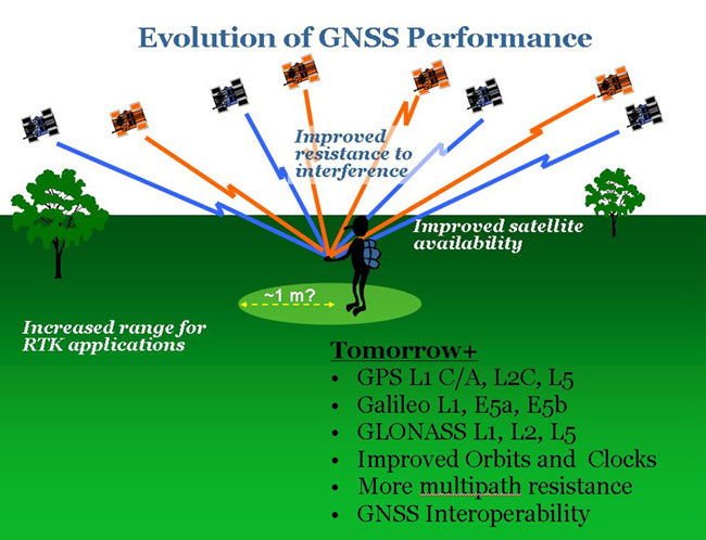
    It is no secret that with the advancing use of GNSS technology, flaws in both existing horizontal and vertical datums establishing our National Spatial Reference System (NSRS) have been identified and exposed.

    NGS estimates that NAD83 is non-geocentric by over two meters, while the model establishing NAVD88 contains a tilt of approximately one meter across our continent.

    For most geospatial practitioners, these flaws are minimal to the integrity of their data. It does, however, give us a glimpse of how assumptions of geodetic information can produce incorrect modeling of surveying and mapping data and could lead to more flawed earth models without significant changes to their structure.

    With a great number of surveying and mapping practitioners using GNSS technology with little or no knowledge of the origins of our NSRS, it is a good time to provide the primers below to explain the history of our geodetic datums.

    Besides my previous article, follow these links for much more thorough technical information:

    GPS World Contributing Author David Zilkoski

    NGS 2022 Informational Videos

    NGS Publications and Webinars

    NGS Video Library

    NGS / COMET Program YouTube Channel

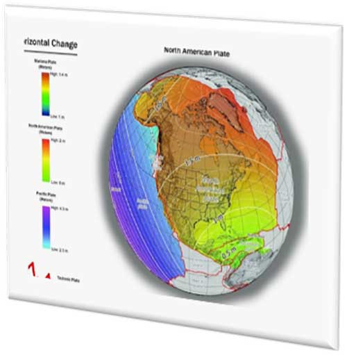
    With changes in both horizontal and vertical datums, slight variations in the data we are used to seeing will seem insignificant, but will require the user to pay close attention to potential data traps when converting between the old and new systems. The NGS graphics below depict the severity of datum change in the horizontal and vertical component across the U.S.

    Image: NGS
    Image: NGS

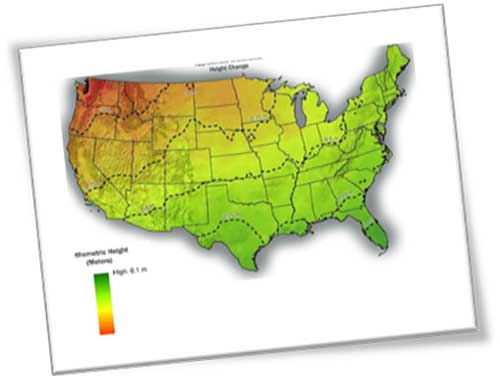
    Depending on where you are working, new state plane coordinates will vary from –2 meters to +4.5 meters from previously published values, with elevations fluctuating up to one meter from previous norms. All these changes are due to the increased knowledge of our world using various forms of emerging technology not thought possible several decades ago.

    These new measuring methods and studies, including GNSS and gravity monitoring, have allowed scientists and geodesy experts to establish more accurate geographic location systems than past terrestrial ways and procedures.

    We have geodetic monuments and marks everywhere; will they still be usable?

    The short answer to this question is an unequivocal yes, but with some caveats. Use of GNSS monitoring has proven we reside on tectonic plates that move slowly over time; thus, the geographic values (latitude and longitude) used to calculate any number of coordinate value systems are changing as well.

    Image: NGS
    Image: NGS

    Relational data between established points are not likely to change, but studies have shown significant shifts in areas that result in movement of our previously considered “unmovable” monuments.

    With additional parameters and characteristics being introduced with the 2022 datum, time and tectonic plate shift are main factors in establishment of a point.

    The concept of a “permanent” point no longer exists in relation to a published and unchangeable coordinate value of horizontal and vertical data. The surveying and geospatial data collector must recognize that the user is establishing a particular X/Y/Z or N/E/Z value for that exact moment in time and it, theoretically, will change from the moment one steps away from the point.

    This may be too “splitting of hairs” for most users, but the new system simply recognizes the reality of the moving data-collection stage, no matter how minute.

    This datum re-establishment has been a monumental undertaking (no pun intended), and NGS deserves many kudos for coming up with a realistic solution for a complex problem.

    However, most of its users still have a problem, and it lies within the standard unit of measurement: the U.S. survey foot. NGS (and its predecessor, U.S. Coastal and Geodetic Survey) have always used the meter for the basis of all units of measurement (as does the rest of the world.) The new 2022 datum is bringing us, the surveyors and mappers, to a new reality — nationwide adoption of the international foot. Let the grumbling and arguments begin!

    The meter vs. international foot vs. US survey foot

    The unit of measurement aptly named the “foot” has existed since early times, with most sources crediting King Henry I of England making a decree that his foot shall become the standard for measurement.

    No matter where the definition of the foot came from, it has varied slightly throughout history. The origin of the meter (or metre, as it’s known worldwide) also has a variety of beginnings. The most established story starts from John Wilkins, an English philosopher, who published in 1668 what he described as a new standard of measurement based upon the length of a pendulum that swings approximately 38 inches across in one second. This length was eventually named the meter by an Italian scientist.

    Another century later, King Louis XVI of France issued a integration law establishing the modern metric system with weights and measures having a base-ten system of units and sub-units. Within this system was the meter with a new length definition of being one ten millionth (1/10,000,000) of the distance from the North Pole to the Equator.

    Upon completion of the calculations, a rectangular bar made of platinum and iridium was created to establish the “standard” meter from which all future measurements would be based.

    The United States first recognized in 1866 the metric system and the meter (set forth as one meter equaling 39.37 inches). During this time, the International Commission of the Meter officially adopted the physical meter bar as the standard.

    Over the next 100+ years, many studies were undertaken to re-establish the length of the meter. Using wavelengths of various elements, including cadmium, mercury, neon, zinc, helium, thallium and krypton, new definitions were created. In 1983, the current definition of the length of the meter was finalized.

    The meter is now based upon the speed of light in a vacuum (299,792,458 m/s) with the meter being the length traveled in 1/299,793,458 of a second. While the length is very close to the original measurements set forth over the centuries, it is better defined for reproduction worldwide without having to possess a standard bar or other device.

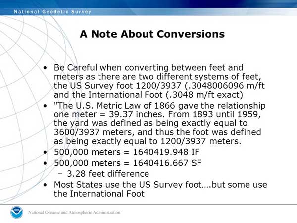
    To further muddy the standardization of units, in 1959 an international agreement was made by Australia, Canada, New Zealand, South Africa and the United Kingdom so one yard would equal 0.9144 meters. Meanwhile, the U.S. National Bureau of Standards published a notice that all survey-related measurements will remain based so one one yard equals 3600/3937 meters or 0.91441083 meters.

    Image: NGS
    Image: NGS

    We have two different measurements for the foot. What’s the big deal?

    The difference between the two standards is two parts in one million; while that doesn’t affect everyday physical measurement, it does cause havoc on coordinate systems with values beyond the millions. (See NGS video “Two Right Feet?” for details).

    What makes it even more confusing is that states across our country vary on which “foot” is standard within their legislation and daily practice. Currently (at the date of publication), six states recognize the International Foot as their standard unit of measurement, with four states not defining it. The remaining states have officially adopted the U.S. survey foot as their standard unit of measurement.

    NGS has suggested that starting with the 2022 datum change, the U.S. survey foot will not be supported in applications and software produced by them for geodetic computations. It will be limited to meters and the international foot, so they are recommending that states update their existing definitions to change to the international foot along with recognizing the 2022 datum as the official coordinate-system base.

    How to train our profession, the construction industry and John Q. Public on the new datum

    I would be lying to you if I said I’m not concerned with the rollout of the new datum and with converting all surveying and mapping work to the international foot. My biggest concern is not with those direct relationships I have with my staff and fellow professionals within my company.

    My main concern starts with these two areas: the tens of thousands of surveying practitioners working within projects containing state-plane coordinate systems in addition to contractors and other mapmaking providers using survey-grade equipment for construction and other mapping applications.

    Both groups have little to no technical knowledge of the intricacies of state-plane coordinate systems and the geodesy network “behind the curtain.” To paraphrase a well-known mortgage company with an app-based home loan system, “push button, get data” is the limit of most users’ knowledge when it comes to state-plane coordinates.

    Add to this the double-edged sword of real-time networks, where the user does not have to be concerned with setting up a base station, and the potential problems could get worse.

    While there will be a few early and timely embracers of the new datum, the majority will dig their heels in and refuse to switch. When the conversion to the 2022 datum is upon us, many users will drag their feet on learning about the new system as existing projects continue under the old datums.

    Until there is a mandate by government agencies and others, many newer projects beginning around the adopting time will remain on NAD83 and NAVD88 until directed otherwise.

    Most practitioners I have spoken with on this issue agree that it will be a tricky period for surveying and mapping. Rather than get bogged down with negativity and fight change, the surveying, mapping and geospatial community should do the following:

    • Rally our professions around these significant changes to educate our technicians and future professionals.
    • Coach contractors and other trades who rely on the technology to understand the new system.
    • Work with governmental agencies at all levels to educate them about what these changes entail and why to make the appropriate revisions to codes and statutes now.
    • Capitalize on this opportunity to teach the public about who we are and how spatial data is part of everyone’s life.

    All these points are paramount to the success of the datum upgrade and need to be followed through to the end. Ultimately, the faster we adopt and adapt, the better our geospatial world will be. There is lots of work ahead of us, but as the staff at NGS has shown us, the hard work necessary to make significant change is well worth the effort.


    CALLING ALL SURVEYORS AND GEOSPATIAL PROVIDERS!

    NGS announces GVX data format for GNSS vector processing

    The National Geodetic Survey (NGS) is requesting input and feedback on a new data format for sharing real-time kinematic (RTK) GNSS vector information.

    The new format will be like the static GNSS standard, Receiver Independent Exchange (RINEX), and is utilized by most software packages and the Online Positioning User System (OPUS).

    The new GNSS Vector Exchange format (GVX), will introduce a new industry standard for sharing of RTK vectors across differing platforms and software packages.

    Earlier users of GPS-based data collection remember the number of proprietary files created by each manufacturer, and having their own unique format for data and attribute interpretation. In response, the NGS created RINEX to help standardize data collection as a universal file format that would easily be adopted by receiver and software producers.

    That same goal is being set with the introduction of the GVX format as the next step in data-collection standardization for GNSS RTK vectors. GVX elements include (but are not limited to) the following:

    • Mark-to-mark Earth-Centered, Earth-Fixed (ECEF) vector components
    • Variances and covariances of vector components’
    • Reference frame information
    • Start and stop time of the observation
    • A-priori coordinates for the end points of each vector
    • Receiver and antenna types
    • RTK and real-time network (RTN) settings, if applicable
    • Quality control metadata (e.g., PDOP, number of satellites used, orbit type, etc.)

    The introduction to the new format along with technical specifications and examples are on the NGS website.

    The National Society of Professional Surveyors (NSPS) works directly with NGS to provide input on maintaining and updating the National Spatial Reference System and will include significant assistance with educating geospatial data providers with the upcoming 2022 datum change and implementation of the North American Terrestrial Reference Frame of 2022 (NATRF2022).

    Image: NGS
    Image: NGS

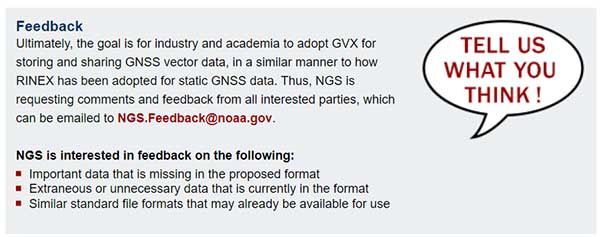
    You can send your feedback here.

    For more information, visit the NGS website.

    Takeaways from this geospatial refresher…

    The surveying, mapping and geospatial professions have exciting times ahead with these cool upgrades from NGS, so we need to take advantage of the calm before the storm to educate ourselves to make the most of the opportunity.

    Geospatial data surrounds all of us, and we are the profession specifically educated for correctly and efficiently keeping a handle on it all. It all starts with growing your knowledge a little bit each day. Please join me in growing the profession as well.

  • What Gen X means for the future of surveying

    What Gen X means for the future of surveying

    Photo: iStock.com/Georgijevic
    Photo: iStock.com/Georgijevic

    The surveying profession has come to a crossroads, and is divided amongst itself to boot. A gap exists within the profession, and yes it is a generation gap, based on how technology has evolved and how the different generations experience it differently. In this column I explore the histories both of the generations and the technology to reach conclusions on how best to move forward — together.

    Surveyors now have more tools than ever before available to them to perform their tasks. But surveyors of different ages regard these tools differently. Not to put too fine a point on it, the younger porfessionals among us feel their creativity and desire to further the profession is being stifled by the group who is supposed to be leading and mentoring them.

    Why is this crucial to consider? Because these are the future users, purchasers and adopters of geospatial equipment and software, and the future setters of industry standards. All involved, from manufacturers to distributors to surveyors themselves, would do well to think deeply upon this.

    As we enter the final stretch of the 21st century’s second decade, many things have changed since the Y2K scare and the proliferation of the Interweb. From deregulation of the surveying profession to changing coordinate systems and datums, the surveying profession faces many challenges in 2019. One of the biggest challenges we face has nothing — yet everything — to do with technology.

    Talented people are necessary to grow our profession. We are falling well short of having enough to keep up with demand. Sounds like a simple problem; just hire more surveyors and technicians. This sounds easy, but several roadblocks confront us.

    A select few still invest in their surveying future by going to college to get a degree and eventually become a licensed surveyor. These individuals find, however, that the road to success has lots of potholes along the way, just as their elder predecessors did.

    Recently, I participated in a group discussion with the National Society of Professional Surveyors (NSPS) Young Surveyors Network to discuss surveying, technology and the young surveyor’s role in promoting future career opportunities. This discussion was part of Network’s series of meetings and seminars held in parallel with the main NSPS Spring Business Meetings.

    It was great to see the higher proportion of women in the young surveyor group than in the typical professional society meeting. Their feedback was consistent with that of the young men in the group. All together, their perspectives led me to write this article.

    While I think of myself as still “young-ish” (in my early 50s), being the oldest participant in that group was intimidating, to say the least. These young technicians and surveyors are driven and focused, yet they seek the same feedback and mentoring that I desired when I was their age.

    In the weeks after that meeting, some of the items discussed continued to resonate with me and forced me to reflect on my own experiences and career path. To be fair to them and truly understand their views on today’s surveying profession, I needed to look beyond the profession, policies and procedures to which I hold fast in my ethical approach to the craft. These younger generations have been exposed to a completely different world than the one I remember fondly, and the world they grew up in has subjected them to challenges to which I cannot relate. To help explain the conundrum of trying to find a way to relate, we need to take a step back and look at not just generational values but how the many industrial revolutions have affected us as well.

    TALKING ‘BOUT MY GENERATION

    The first part of my research to help me find a way to step into the shoes of these young surveyors was to look at past generations and how they relate to each other. Going back to the turn of the 19th century, we get the following breakdown:

    Traditionalists or Silent Generation: Born before 1945

    This timeframe contains sub-groups including the “lost generation of 1914,” the “interbellum” and the “greatest generation.” Alaska and Hawaii were not included in the United States during this period. Most of the country west of the Colonial states was subject to the government Public Land Survey System started in the early 1800s. The Great Depression took its toll on much of the population, and previously rapid expansion slowed to a standstill.

    Baby Boomers: Born 1946 – 1964

    World War II changed the world. Soldiers returning from military duty to start or resume families accelerated population growth and a departure from traditional social attitudes. Two-income families emerged, and prosperity ruled for many years. Surveyors, teaming with civil engineers, helped fuel an unprecedented explosion of real estate expansion through planned developments across the country.

    Generation X: Born 1965 – 1976

    The children of the fast and free-living Baby Boomers grew up to become the Gen Xers. They were the first “latchkey” kids, more likely to be raised by divorced or remarried parents. As young adults, in their effort to enhance their lifestyle more than their parents, they did many things to the extreme with no consideration of cost. This led to massive real estate developments, “McMansions” and increased debt. Surveying continued to flourish but most growth was enjoyed by engineering firms who absorbed surveyors to expand their services.

    Millennials or Gen Y: Born 1977 – 1995

    This group is often labeled as the “Peter Pan” generation for its predisposition to put off typical adulthood norms like marriage, having children and buying real estate. They have a propensity to be more mobile and nomadic, as they take advantage of technology and rapidly changing environmental factors. With this generation we find the slowdown in career choices towards surveying, even though technology and spatial data acquisition have exploded with potential.

    Gen Z, iGen, or Centennials: Born 1996 – Current

    This generation was born into technology, and it affects everything they do. From infancy they were experienced soothing music, dancing screens, interactive toys, and dolls teaching them new skills. This generation doesn’t know of a world without computers, cellphones, GPS-based maps or high-speed internet. Surveying has also benefitted from the technology explosion but it hasn’t captured the imagination of this generation sufficiently to develop future practitioners.

    YOU SAY YOU WANT A REVOLUTION. WELL, YOU KNOW…

    The generational differences only tell part of the story. Each one faced its own challenges when it came to technology (or lack thereof), societal standards, and other facets of their respective eras. A succession of several Industrial Revolutions brought new tools for completing a wide array of tasks and procedures. Here is a summary of each of them in chronological order:

    First Industrial Revolution (1784)

    Mechanical production via water and steam power led the way during the late 1700s and began a trend of radical changes in the ability to create larger items. The Gunter chain and surveyor’s compass, both invented in the 1600s, were the mainstay of measuring tools during this time period.

    Second Industrial Revolution (1870)

    Mass production and increases in labor opportunities coupled with the adaptation of electricity in many areas enabled people to flourish like no other time to date. The optical theodolite with horizontal angle measurement was introduced and then mass produced in the late 1800s to help surveyors make more progress westward.

    Third Industrial Revolution (1969)

    A significant leap forward in technology occurred with the invention of the microprocessor in the late 1950s, followed quickly by rapid development of electronic machines designed to follow manual instructions. Programmable controllers and devices were born from the fast-paced development of sophisticated miniaturized circuitry. These developments were used to create measurement devices for sending infrared and visible light waves across long distances. In the late 1970s, technological advancements led to the development of electronic theodolites or total stations. These instruments were the first to be able to electronically determine the horizontal and vertical angles normally read manually by the operator, and to combine this data with electronic distance measurement. Further development created methods of storing this data electronically for input into computer calculation and drafting programs.

    Fourth Industrial Revolution (Current)

    Industry experts differ as to when the Fourth Revolution began, but all agree we have turned the corner and are now fully entrenched into a new realm. Further miniaturization of computer chips, advanced sensors and storage, and robotic mechanisms have introduced a new reality for everyone, including the surveyor. Today’s practitioner has many sophisticated tools available for work, including GNSS receivers, laser or LiDAR scanners, UAVs with a multitude of sensors, hydrographic vehicles with single and multi-beam fathometers, and many more instruments currently under development.

    Surveyors now have more tools than ever available to perform their tasks. Now we must cross-reference these revolutions with the practitioners from the various generations to help us understand upon which road the profession is headed.

    TECHNOLOGY MEETS GENERATIONAL DIFFERENCES; WHAT COULD GO WRONG?

    One thing that stood out in my aforementioned discussion with the young surveyors’ group was how much they were embracing technology not just in their every day lives and communication, but how they understood the enhanced abilities of the latest tech and instruments for surveying. They see the value in large data, point clouds and BIM (building information modeling) needed for industry use.

    The general consensus from this group was that my generation (Gen X) and earlier (Baby Boomers) are easily dismissive of their enthusiasm for incorporating these new technologies into our workflow simply as ways to shortcut old methods done by more labor-intensive means. While I initially tried, myself, to dismiss this suggestion, further research has only proven their point: their creativity and desire to further the profession is indeed being stifled by the group that should be leading and mentoring them.

    Cross-correlating the generations with their various personalities and quirks with the amalgamations of industrial revolutions turns up some interesting results. Gen Xers and earlier surveyors were strictly taught by their managers and mentors that both historical data and original monuments are sacred and not to be denied. This information was derived from the most basic of survey instruments and measuring equipment, with accuracy that is not acceptable by today’s standards.

    But the tradition remained: if it was good enough for our forefathers to establish the early frontier, then more accurate measuring devices are simply overkill. New sophisticated robotic total stations, GNSS receivers and robust data collectors available as a result of the Third Industrial Revolution are shiny objects that stand in the way of “good surveying,” in the opinion of the elder surveyors.

    Millennial surveyors, meanwhile, look at the world with a different vision and much different solutions. Most of them were not exposed to televisions with just three channels, telephones mounted on walls, or kitchens without microwave ovens, to just to name a few “antiquities.” Their families have always owned a computer and the library is a place where you go to study. Research isn’t looking in an encyclopedia; you Google. They embracw cellphones with a multitude of apps and functions, including location services within a few feet, practically as extensions of themselves.

    The equipment produced for surveyors today is well within their wheelhouse as it maps a multitude of points and features in a blink of an eye. Accuracy and detail are no longer an issue — but adapting that data to legacy deeds and maps is where us old timers can help bridge the gap.

    Another problem that has proven to be a yawning void between the generations is the remnants of the economic slowdown of 2007-2012. Many Baby Boomer and Gen X surveyors learned to do more with less. Times were tough and we couldn’t afford to upgrade to the latest versions of total stations, GNSS, software, or invest in new technologies like laser scanning. There was also an exodus of technicians simply because there was no work in surveying for the time period, and they found employment in other professions. That left a void in who was doing the work (now being completed by upper level surveyors with older skill sets), and having no younger personnel to train and groom for future career growth.

    There were many technological advancements during that time frame but overall the industry suffered because of the economic downturn. The Millennials, most of whom were too young to be employed during this period, now are faced with working for an older profession that couldn’t afford to stay current with technology and who have trouble relating to the motivations of the younger generation.

    CAN’T WE ALL JUST GET ALONG?

    I believe the surveying profession is at a crossroads, one based upon the gap caused by the generation / technology combination described above. Steps must be taken to rectify this. Here are a few of the pathways to closing the gap and becoming a solid profession for the future:

    1. Embrace the mentor/mentee relationship, but be open to reversing the roles. The younger generations have a handle on the latest technology, so us old timers need to be more willing to close our mouths and open our ears and minds.
    2. Create more opportunities for younger surveyors to participate in organizations so they can also be influencers. Keep in mind that they don’t typically like to “belong” to an organization, so adapt our professional groups and keep their interests in mind.
    3. Change the way we communicate. Many Baby Boomers / Gen X members are critical of the younger generations and social media, yet this trend shows no sign, at all, of stopping. Smartphones are here to stay, so let’s learn to adapt, to remain in step with the youngsters.
    4. Be willing to invest in new and emerging technology. Who know where the next radical survey technique will come from if you don’t have an open mind and checkbook? Invest not only in equipment but your young staff’s future.
    5. Encourage younger staff to get involved in something. Anything. Social interaction can lead to better communication skills and expose them to more business situations. Don’t push them in over their head,s but get them to be “uncomfortable” occasionally. They will thank you for it.

    Many professions and occupations will suffer in the next 3–5 years because of attrition through retirement, incapacitation and death. These workforces will lose 20–40% of their workers. Those left will have to pick up the slack and then some. We need to either

    A) hire a lot more surveyors, or

    B) figure out how to make it work with less bodies.

    The conversation that took place in that meeting room with the young surveyors has made a deep impression on me and has changed my focus on the future of surveying. How does this apply to an article in a geospatial publication? Simple: these are the future users, purchasers and adopters of geospatial equipment and software, and the setters of industry standards.

    The younger generation understands how to use today’s technology, and the surveying profession overall needs to embrace that fact. The technology won’t mean a thing if we don’t have the bright minds to use it to its full potential.

    So I ask you again to embrace, encourage and listen to the young surveyors; they will thank you for it.

  • Surveyors and smart cities — partners in technology

    Surveyors and smart cities — partners in technology

    Image: Celebrating200years.noaa.gov
    Image: Celebrating200years.noaa.gov

    Everywhere we turn today, the term “smart” is attached to an item or to a process. Smartphones, smart cars, smart electricity grids, smart home appliances; you name it, someone is making it a “smart” item or process. Advancement in technology has increased computing power, expanded data storage capability, and has allowed for miniaturization of circuits and processors. This forward progress has led to the creation of these smart item/processes, and together creates the real possibility of making many of life’s tasks and normal operations more automated. This potential automation also brings new systems monitoring conditions of various entities and operations within our daily lives, such as increased efficiency of HVAC systems, utility metering that adjusts to our patterns of consumption and landscape watering that only provides water when needed.

    In addition to the personal systems now being controlled with these machines, there is now revitalized interest in the creation of “smart cities.” The concept of this type of a civilized urban metropolis once existed only in science fiction, but technology has brought this concept to life in ways not imagined by the best of those writers. Surveyors have a big role in the development, installation and maintenance of these cities, so let us spend some time digging into the element that go into our future environments.

    What is a smart city?

    For those old enough to remember, the concept of a smart city only existed on “The Jetsons” cartoon from the early 1960’s, with cities in the sky, flying cars and some technological advancements that do exist today. While Orbit City may not come to fruition in the next several generations, many of the concepts of a smart city are taking shape today.

    For the definition of a smart city, we go to the Google search engine and find the following entry from Internetofthingsagenda.techtarget.com:
    A smart city is a municipality that uses information and communication technologies to increase operational efficiency, share information with the public and improve both the quality of government services and citizen welfare.

    Establishing a smart city requires forward thinking leadership and substantial funding to be created and maintained; however, the real function lies within the computing infrastructure and collection/manipulation of large quantities of data to create an environment of efficiency and conservation. A true comprehensive system combines available historical data, a collection of sensors and data collectors transmitting real-time information, and a powerful computing system containing analytical programming with extensive database functionality.

    Is smart cities technology and adoption really that important?

    Population trends worldwide continue to show that urban and suburban areas are expanding while rural areas are seeing a large reduction in residence. Several factors are at play, with technology being the central reason for the migration from the farm/small towns to the bigger cities.

    Statistics show that in 1960, two billion people worldwide lived in rural areas while one billion lived in urban sections. As the population has increased drastically, the percentages for each category have reversed; in 2007, the two categories were equal and by 2017, the urban sector has jumped to 4.13 billion versus the rural population of 3.4 billion.

    Chart: Our World in Data
    Chart: Our World in Data

    Population experts estimate by 2050, upwards of 70 percent of the world’s population will be living in urban areas. Whether this population shift goes directly to the city centers or the less dense outskirts, municipal facilities and services will need to be upgraded and expanded with the continuing trend. Add to this surge the challenge to create a more sustainable environmental infrastructure and ecosystem, and it becomes a maintenance challenge and logistical nightmare. By using technology to create smarter infrastructure monitoring and management systems, the creation of smart cities with advancing technology will be key to successful and sustainable growth for municipalities and its citizens.

    One of the biggest challenges faced by most municipalities is aging infrastructure. Utility systems, including water supplies and stormwater drainage, was installed several generations ago without a plan for replacement and/or expansion. Redevelopment in older urban areas are now taxing these aging systems well beyond their initial capacity, all while these facilities begin to fail simply because of continued use well beyond their original designed life span. Municipalities are forced to spend money on repairing and modernizing the existing infrastructure before entertaining the idea of upgrading new installations to “smart city” specifications. However, many municipalities are mandating that new developments and infrastructure improvements meet these specifications so any future upgrades can include computerized systems.

    All these systems, new and future, will require extensive planning and mapping to be effective and efficient to justify their expense. Surveyors, utilizing a variety of tools based around high-accuracy mapping and data collection, can provide the necessary base information for these systems.

    Where does surveying fit in?

    Just as computers and electronic technology has allowed many industries to evolve, the surveying profession has also advanced with new methods and equipment. Our ability to perform advanced measurements and establish positional location information is critical in providing the base data necessary for smart city services. Previous surveying, mapping and record keeping systems were sufficient for the needs of the time period. However, these historical data points were nearly impossible to place into a single database simply because of one factor: georeferencing.

    The surveyor has the unique responsibility of being recognized as expert measurer and locator of physical points on the ground in relation to property and boundary rights. It is because of this distinctive role within the community that the surveyor can provide a significant role in the development of the groundwork of a smart city. The introduction and implementation of newer technology and tools has allowed the surveyor to become a valuable member of the infrastructure mapping team. It always hasn’t been this way and the surveying profession shoulders most of that blame.

    Past promises: digital vs. smart

    Many surveyors will make the argument that our profession has been ahead of the game for years with our data collection processes having been transformed from notes in a field book to electronic devices. Digital data, however, isn’t necessarily smart data as many factors go into establishing the difference. The physical form of the survey information has no direct correlation to the basis of the data; in this case, the records need to be based upon a spatial reference frame rather than an assumed data system.

    Also on the topic of spatial reference systems, we can also address the lack of respect given to geographical information systems (GIS) from surveyors during its initial introduction and implementation. GIS was discounted as a convoluted graphical database not sophisticated enough for the high-accuracy world of surveying. Little did the surveying profession know that GIS would become the spatial basis for many mapping systems and be utilized in millions of locations worldwide. Only now does the surveying community realize that we missed the bandwagon and can help to provide the crucial link between spatial data and actual points on the ground in relation to physical improvements and property ownership.

    Another digital platform not initially embraced by the surveying community is building information modeling or BIM. This software is a three-dimensional modeling program used mostly by architects and mechanical engineers for depicting and designing buildings and plumbing systems. One of the advantages of BIM versus traditional CAD is a database information link containing data regarding the entities within the BIM. Among the attributes contained with BIM are documentation, spatial reference, time, cost, operational applications, and related applications (contracts, purchasing, suppliers, procurement solutions, etc.). The existing spatial data necessary for this system can be supplied by surveyors using a variety of methods but not many have implemented the software.

    Technology, availability, cost of entry and overall usefulness

    Surveying instruments and measuring techniques has turned a significant corner in the past two decades. While conventional measurement methods are still used (including steel tapes, laser-based total stations, and GNSS receivers), more types of sensors are being introduced to enhance the accuracy and expand the volume of data points being collected. Scanners, using phase-based and time-of-flight methodologies, are now more popular than ever as ease of use has increased while the cost of ownership has greatly decreased. Ground-based and mobile LiDAR used to be only available to large firms and the government, but new models are being introduced at price points affordable to many surveyors. Many articles have been written regarding the lightspeed adaptation of surveying, engineering and construction firms with UAV use of photogrammetry methods to quickly map areas that were previously inaccessible and meeting standards not thought possible. We are also seeing more implementation of new scanning methods, including SLAM (simultaneous localization and mapping) using handheld and backpack devices.

    The common thread for all these technologies and methods is one thing: georeferencing. What was once nearly impossible is now a reality; data collection from various methods all being located within a common horizontal coordinate and vertical datum systems. The ability to obtain literally millions of data points with high-accuracy horizontal and vertical values is phenomenal with most of the credit going to the United States Department of Defense and their implementation of the GPS. Yes, the technology of scanners and data collection would have been invented without the overall coordinate tie-in but having the ability to reference that same data to a common system is the key.

    Also key to the smart city data collection methodology is the surveyor as the expert measurer. A trained and experience surveyor can lead the data collection of significant projects, including location of existing improvements and establishment of future installations. From establishment of parcel/right-of-way lines to integration of point clouds from scanners and photogrammetry, the surveyor can assemble this data together to provide the groundwork for successful analyzation and planning. By combining data from various areas of a municipality, including utility atlases, existing improvements, and future expansion plans, a database can be created in which a smart city will rely upon for oversight and monitoring. The surveyor fills a vital role to determining the accuracy and effectiveness of data like no other profession and should not be overlooked when assembling a team for the creation of a smart city.

    Future opportunities

    Like all technological discoveries and enhancements before, the future is bright with many possibilities to increase the effectiveness and efficiency of a smart city. More types of sensors are being introduced on a regular basis and in every way imaginable, including wireless communication, RFID tags, and microelectromechanical systems (MEMS) devices.

    Image: GetKidsintoSurvey.com & www.elaineball.co.uk
    Image: GetKidsintoSurvey.com & www.elaineball.co.uk

    One of the latest buzzwords is the “Internet of Things” (IoT), with many new devices being created to interconnect a network of web-enabled computerized devices using microprocessors, a variety of sensors and wireless communication hardware to gather, transmit and perform actions on information acquired from their environments. IoT presents advantages to users by enabling them to monitor their overall business processes and improve the customer experience. These actions can also precipitate changes to allow the company to save time and money, enhance employee productivity, integrate and adapt business models, make better business decisions, and generate more revenue.

    As discussed in previous articles (GPS World March 2018 and GPS World November 2018), the next big technology to look forward to is the telecommunications upgrade to 5G. Once a full 5G network is running with extended coverage, we can look forward to new opportunities for indoor location services with similar accuracy to our existing GNSS capability.

    What’s next?

    The technology sector will continue to push the limits of computing speed, physical size and data capacity looking for the “next big thing.” The surveying profession has enjoyed many of the fruits of that success so one has to imagine that many more advances will be coming soon. Smart cities will continue to evolve as citizens of Earth keep migrating to the urban areas and forcing the existing infrastructure to expand or face failure. Surveyors will continue to help provide a variety of services to those citizens and municipalities, with an eye on the future for more advancing technology. I can’t wait to see what is next.

  • Expanded GNSS and 5G: A gift for the surveyor

    Expanded GNSS and 5G: A gift for the surveyor

    Regular readers of GPS World are aware of many of the rapidly developing technologies and navigational systems being created around the world, but often the everyday surveyor shows up late to the party.

    While smartphones get the most mainstream media coverage, other navigational devices and measurement systems are adapting to evolving technical breakthroughs and new methods of transmitting a variety of data wirelessly.

    This month’s article looks at the increase in satellite navigation networks along with the rollout of 5G cellular technology. Both advancements will benefit the surveying community; to start, I’ll explain what this means for accuracy and precision of survey measurements as well as productivity.

    Everybody gets a constellation! (with apologies to Oprah)

    I’ve been known to wax poetic in this column about my admiration of GNSS technology, and I continue to marvel at the “accidental” civilian use of a military tool. This method of measurement and navigation continues to expand, refine and transcend everyday life, and surveying is no exception.

    The satellite constellation is the mainstay of this navigational system. The United States began the charge several decades ago, but other nations are quickly catching up. Let’s look at the current constellations and their status.

    Operational Systems

    • GPS (United States)
    • GLONASS (Russia)
    • Galileo (European Union)
    • Beidou (China)
    • QZSS (Japan)
    • IRNSS (India)
    Chart: GPS World
    Chart: GPS World

    There are now more satellites. What’s the big deal?

    The addition of these constellations provides large gains for the surveying community in several different ways.

    First, the additional satellites mean more signals to help with the mathematical equations necessary for positional determination. While traditional surveying in the general public’s eye is associated with measurements on the ground, our expansion of services into the air and water relies heavily on GNSS determined positions.

    No matter what type of remote sensing equipment is being used (lidar, photogrammetric, sonar, etc.), positional determination for most of those sensors are derived from GNSS-based receivers. Add to these measuring methods the ability to perform operations via remote-controlled or autonomous vehicles in both air and water, and the availability of additional satellite signals enhances the reliability of GNSS-derived data and attributes.

    Second, by having more satellite signals to utilize, GNSS receiver manufacturers can improve the software for processing the positional information with greater certainty of accuracy.

    Before the introduction of additional constellations and receivers with expanded signal reception, GNSS users relied on less sophisticated software to identify potential “bad” signals that would lead to incorrect positions. While the software generally provided reasonable reliability, it was not foolproof and occasionally would allow bad data to be accepted.

    Like most everything tech-related, however, the GNSS industry has benefited from increased computing power to go along with the additional satellite constellations. The latest GNSS receivers can accept well over 500+ signals from a variety of sources (including land-based transmitters). The software used to reduce all that data has increased in complexity along with number of those data sets.

    Complex computations that were once limited to mini-computers or even mainframes are now being completed on handheld data collectors in minuscule timeframes compared to their predecessors.

    The software has also been enhanced to analyze the data in real-time, compute the likely position of the receiver and notify the user of potential incorrect or “spoofed” data from any number of satellites.

    Considering that many of the remote-sensing sources now collect millions of points based upon one GNSS-based position, the need for increased positional verification has become a critical issue. By having many more constellations to provide signals for positional data, the percentage of establishing a correct location for each data point has increase significantly.

    The improved computing power and verification ability of today’s GNSS software is helping to eliminate errors in positional accuracy and instill more confidence in the surveyor’s data collection activities.

    Add to these additional constellations the planned installation of more land-based signal providers to augment or provide a backup plan for satellite systems, and it’s clear that the future is quite bright for GNSS-based receivers and data collection for everyone — especially the surveying community.

    The history of wireless communication

    While surveyors marvel at the advancements of GNSS-based measurement, it pales in comparison to the rapid growth of modern technology with cellular devices. Notice I didn’t write cellular phones, as the technology has quickly established itself as much more than voice communication. Before we lay out the future of cellular data networks, let’s take a step back and see how this type of communication has revolutionized GNSS-derived data collection for surveyors and others.

    Two-way, CB and shortwave ham radio

    1947 two-way radio advertisement. (Image: Motorola)
    1947 two-way radio advertisement. (Image: Motorola)

    The technology behind wireless communication goes back several decades, but didn’t become a mainstream system until the late 1970s and early 1980s. Motorola is known as the early force behind the two-way radio system, but the base and remote transmitters were not cost effective for small businesses. This type of system was also limited to single-purpose radios with individual crystals wired within that only allowed specific frequencies to be transmitted.

    Another type of communication used by some was the citizens band radio, affectionately referred to as CB radio. This radio was limited to 40 channels and didn’t allow for private transmission between two parties. During the 1970s, the use of the CB radio was not limited to long-haul truck drivers — many people used the medium for basic communication.

    Vintage CB radio ad from Radio Shack. (radioshackcatalogs.com)
    Vintage CB radio ad from Radio Shack. (radioshackcatalogs.com)

    Telephone service during these times was still costly and long-distance calls were not cost-effective, so many found the CB radio as an alternative to conventional phone service. Looking back now, it is not a stretch to classify this type of broadcasting as a primitive social media precursor to today’s methods but limited to live chats and no visuals.

    Another method of transmission was short-wave radio. This system was like two-way radios with an established base transmitter, but broadcast on public frequencies over greater distances than CB radios. One of the big drawbacks was the upfront costs, which were much more significant than the other radios. Even more expensive was outfitting a vehicle with a shortwave system, so cost was the biggest limiting factor for this mode of communication.

    Pagers of all shapes and sizes

    Motorola's Pageboy pager. (Photo: Motorola)
    Motorola’s Pageboy pager. (Photo: Motorola)

    The popularity of telephone-based pagers didn’t hit its zenith until the early 1990s, but the technology and actual use dates to the early 1960s. The first commercial pager was produced by Motorola in 1964 and called the Pageboy. There was no screen or display; the user was notified by a variety of tones preset for distinct situations or needs. As this technology advanced, variations in screens, message types and even two-way communication became possible.

    By 1994, there were more than 60 million pagers in use, but a change was in the technological wind; cellular phones were marching toward the mainstream.

    Cellphones on every street corner

    Motorola DynaTAC 8000X portable cellular phone, 1984. (Photo: Motorola)
    Motorola DynaTAC 8000X portable cellular phone, 1984. (Photo: Motorola)

    While the concept of wireless telephone communication existed in several laboratories around the world for years, the first big breakthrough was made by researcher Martin Cooper, who developed a prototype cellular device for Motorola in the early 1970s. He famously made the first public cellular phone call on April 3, 1973, to Joel Engel, head of research at Bell Labs, during a walk in New York City. Cooper and Engel were engaged in a rivalry to develop the first commercially available cellular phone with the Motorola DynaTAC prototype being the first to make a successful call.

    However, the rush to get cellular phones to market took longer than anticipated. It wasn’t until the introduction of the Motorola DynaTAC 8000 in 1983 (available to the public in March 1984) that the reality of wireless phones came to life. The cost of wireless freedom came at a price: $3,500 for a brick-sized phone that took 10 hours to charge for 30 minutes of use. The cost of the service was also expensive due to the limited cellular infrastructure.

    The next decade brought us expanded cellular coverage along with miniaturization of phone; each subsequent model provided more features and longer battery life. From the Nokia “candy bar” to the Motorola Razr, the cellphone era had engulfed the mainstream, but more changes were ahead for mobile communications.

    The late 1990s saw the introduction of the cellphone as a computer modem, with limited email connectivity and primitive internet browsers built into the operating systems. But like many electronic technologies that came before, the cellphone would begin a radically different life in the mid-2000s.

    Enter the smartphone to help us dummies

    The IBM Simon Personal Communicator and charging base. (Photo: IBM/public domain)
    The IBM Simon Personal Communicator and charging base. (Photo: IBM/public domain)

    Officially, the smartphone has been in existence since 1992 with the creation of the Simon Personal Communicator from IBM. At a cost of $1,100, with a monochrome screen that was 4 ½ x 1 ½ inches, the Simon allowed the user access to email and faxes (remember those?) along with the phone function — but users had to make it fast; the battery only lasted an hour. IBM sold 50,000 of these units before pulling the plug on the project, but it started the trend toward mobile telephones with a graphical interface and extended uses beyond the standard verbal communications.

    Just like the Apple Newton was the failed precursor to the Palm Pilot, various tablets and eventually today’s smartphone platform, the Simon broke ground and established new directions for future communication.

    The early 2000s introduced us to the Blackberry personal digital assistant (PDA) and phones from Research in Motion (RIM), a small electronic communications company from Ontario, Canada. RIM started small with a two-way paging system that became popular in Europe and quickly morphed into cellular devices that worked on the DynaTAC network used by Motorola.

    A recent model Blackberry PDA. (Photo: Blackberry)
    A recent model Blackberry PDA. (Photo: Blackberry)

    By the mid 2000s, their devices became affectionately known as the “Crackberry” as users became addicted to the functions and capability of this communication tool. These devices were popular with business users as the security encryption was considered more effective than any of the other communication apparatuses of the day.

    By 2009, Blackberry had reached the zenith of the mobile device market (second only to the conventional mobile-phone platform dominated by Nokia) but began a rapid decline due to proliferation of the next big thing — the touchscreen smartphone.

    After Apple’s introduction of the iPhone in 2007, followed by a crowd of Android-powered phones in 2008 and beyond, Blackberry’s market share has been reduced to a small niche group.

    And now, why this relates to the surveyor…

    The rollout of Steve Job’s dream of combining Apple’s industry-defining iPod with mobile phone capability revolutionized not only the way we communicate — it has redefined our everyday environment. Many of the tasks we accomplish every day have been incorporated into a smartphone application, which brings us back to the reason this article is directed at surveyors: the device that hangs on your belt or rests in your pocket is revolutionizing the way today’s surveyors work.

    Not that long ago, the only navigational devices available were large, expensive and difficult to use. Now, nearly everyone owns a device with GNSS capability. When we combine the ever-expanding number of devices along with the increased coverage of GNSS satellite constellations, the ability to georeference any piece of data to greater precision and accuracy is improving.

    Surveyors need to embrace this technology within their smartphones to increase their efficiencies. At the same time, we need to help educate the public on why having better smartphone location capability doesn’t mean the masses can perform their own boundary analyses. For more information on this subject, see the GPS World July 2017 article.

    Surveyors should embrace the smartphone as an important tool; the introduction of new survey-grade GNSS receivers that use an app for the user interface will soon become commonplace.

    Several GNSS manufacturers have introduced receivers that exclusively use a smartphone and app for data collection, eliminating the need for a dedicated (and usually proprietary) data collector for obtaining centimeter-level location data. I’m not advocating that the surveying community throw their existing systems in the trash in favor of these newer receivers, but the data-collection techniques utilized by smartphones can increase efficiency and reduce equipment costs.

    The Mi 8 smartphone offers dual-frequency capability. (Image: Xiaomi)
    The Mi 8 smartphone offers dual-frequency capability. (Image: Xiaomi)

    Another reason to pay attention to the smartphone as a location tool will be the expanded use of dual-frequency chipsets to provide even higher accuracies. One of the fastest growing phone makers worldwide is Xiaomi, based in Beijing, China, which introduced the Mi 8 phone with a dual-frequency GNSS chip. This chip frequency reception (E1/L1+E5/L5) is targeted to embrace the Galileo and GPS constellations for increased accuracies (within a decimeter),  well beyond the current norm for smartphones (typically 1-3 meters, plus or minus). For the surveyor, having this capability in their pocket can greatly increase efficiencies, especially when used during reconnaissance efforts. I believe many more phone manufacturers will begin to incorporate dual-frequency chips in their future models to increase location accuracies for users and take advantage of upcoming network enhancements.

    Speaking of network enhancements, let’s talk 5G as a gamechanger.

    The latest buzz in the general population’s lexicon is 5G and how it will push high-speed internet to all corners of the world. While this is a possibility, it means much more to the surveyor than meets the eye. Yes, there will be increased cellular coverage in places that previously lacked it, or only had limited access, but 5G means much more than that.

    Image: NTT DOCOMO Inc. 5G white paper.
    Image: NTT DOCOMO Inc. 5G white paper.

    Let’s refresh our view of what cellphone coverage currently means to the surveyor. The use of cellular-based RTK receivers has been greatly expanded due to the increased coverage of 4G LTE signals throughout the world, but it’s still scarce is some parts. This is mostly due to the transmission of cellular signals being required from towers and higher placed antennas with powerful transmitters. These transmitters are costly and typically owned and installed by the larger telecom companies, so placement is traditionally in more populated areas.

    Enter 5G — while it will provide enhancements for all users, it will be revolutionary for the surveyor. 4G cell coverage was a broad and powerful signal from large transmitters; 5G cellular service consists of smaller cell signals placed in a tight grid of broadcast positions. These transmitters will be more cost effective for many telecom providers and will increase data reception for many users. For surveyors, the additional coverage of 5G will make possible the use of cellular-based RTK GNSS data collection in places not previously possible.

    Besides the extended coverage of 5G, the 10-fold speed of the new data transmission protocol compared old 4G LTE creates many possibilities for information collection growth. Soon it will be possible for a field personnel and the office staff to be linked in real time during the data collection process.

    From boundary-point recovery to complex topographic surveys, a field crew’s work can be supervised and reviewed while being completed, allowing for instantaneous analysis and guidance from senior staff. This process will allow for more oversight, quality control and mentoring of field staff than is possible for today’s remote crew operations. The new technology will also allow for reduced timeframes when crews are required to provide field data for tight deadline requests and gives us a method of instant feedback on the amount and quality of the data collection.

    Some may see this improvement in connectivity as an avenue for office staff to be intrusive on their field activities, but I see this as an opportunity for improved quality control and increased team interaction. More connected teams can lead to improved efficiencies and overall increases in productivity, profitability and morale among team members.

    From outside to inside

    Another breakthrough created by 5G will be the enhancement of indoor georeferenced location services. By having several transmitters placed throughout a facility, trilateration will be possible to provide more accurate location information for places not typically available to surveyors.

    Depending on the accuracy needed and placement of the cell providers, it will possible for surveyors to use devices designed for remote sensing (laser scanners, lidar, SLAM, etc.) and collect georeferenced data with greater accuracy in relation to a known coordinate system. This by-product will also aid rescue and medical providers during emergencies to help pinpoint individuals through their cellphone connection more accurately than before.

    5G is more than just bringing YouTube videos to your phone faster; it will improve the data collection process of all shapes and sizes. Surveyors will not get left out, but we will need to be ready to take advantage when it comes online. For more on the 5G revolution, see the GPS World February 2018 article on this topic.

    As surveyors, just when we think that technology can’t take us further, we blink and change happens. Moore’s law stated (depending on which revision) that technology would double the number of transistors every one to two years. While some may say that technology is making Moore’s law obsolete, I believe the creativity being used to invent new processes based upon the technology is holding strong.

    I, for one, look forward to many more enhancements to follow in the coming years. Surveyors be ready; the future is here.

  • The surveyor and artificial intelligence: A look ahead

    In the not-too-distant future, the following scenario may take place.

    Image: Stockvault
    Image: Stockvault

    A corporation owns an improved property in a large metropolitan city and has decided to sell it to a prospective buyer. Through a series of electronic messages and high-tech operations, the seller, buyer, their respective counsels, lending institutions and a title company are provided with documentation stating the condition of the site along with holograms and 3D digital models worthy of a science-fiction movie. In a matter of minutes, the deal is closed with monies and titles silently swapping places out in the ether.

    Behind the scenes, the surveyor is a big part of this transaction. But how will the operation of the land title survey look in the future? Like everything else, artificial intelligence (A.I.) and blockchain technology will play a substantial role in surveying. I don’t profess to be the next Carnac the Magnificent, but it could look like this…

    HOW IT ALL STARTS

    The seller contacts their corporate attorneys to begin the contractual process. Requirements for the sale include acceptable and insurable conditions of the site and a clean title policy from a title insurance company, so the latest land title survey requirements will be held for site and title review. Once the seller and buyer are committed to a sale of the subject property, a blockchain is established in a transactional database to track every step of the sale.

    Image: GSA
    Image: GSA

    The attorney will consult with “Sheldon,” an artificial intelligence system built by a leading e-commerce company and designed to assist with business-to-business commerce. Sheldon will be used to secure the services of a land surveyor for the transaction. By researching available consultants based upon the information for the parcel contained within the blockchain, Sheldon contacts firms that could meet the criteria for this part of the transaction.

    Once an appropriate firm is chosen by Sheldon, the data for the survey within the blockchain is uploaded to “Thomas,” a digital assistant designed specifically for surveyors. Thomas works with Sheldon and the blockchain to formalize an agreement, secure the necessary insurance requirements, and finalize a payment schedule for services.

    ENTER THE SURVEYOR

    Once the project is secured, Thomas creates a project file, downloads current satellite images, GIS data (including parcel, building and utility information), and recorded documents for the subject parcel. Among the information is parcel data for the project site. This data is based upon historical land surveys and converted into an accurate dataset in which most of the property and land corners are now included in the GIS database. All corners within the database have been installed or upgraded to contain an RFID chip imbedded within the top of the marker.

    Image: NOAA
    Image: NOAA

    These GIS databases also take advantage of ongoing advancements of the North American Terrestrial Reference Frame of 2022 (NATRF2022). Beyond the initial implementation, the National Geodetic Survey has incorporated additional precision gained by improved L5 satellite reception and other nations’ satellite constellations in sub-centimeter location with most survey-grade receivers. Thomas compiles all site data into a comprehensive package for submission to the surveyor.

    Because of the advancements with instrumentation and sensors in locating improvements both above and below the surface of the ground, the latest land title survey standard has moved all optional Table A items into required information to be provided on the plat. The standard also now requires a drainage analysis to be prepared to determine how the subject property relates to the adjacent parcels.

    Thomas reviews the current backlog of project managers and assigns/transmits the project to the first available team. The chosen survey project manager receives the project information and creates an Ethereum blockchain file to work with the master blockchain and begin the survey process. By creating additional survey programming working in conjunction with the project blockchain, all parties involved in the transaction can monitor progress every step of the way.

    The first responsibility of the survey PM is to work with Thomas to evaluate the existing data available for the project location. Current conditions from satellite imagery, improvement and utility information from existing governmental GIS databases, and parcel/easement information from recorded document sources are used to determine flight paths for UAVs utilizing multiple sensors, avoiding substantial obstacles. This process will also establish areas to be surveyed/verified by mobile methods where aerial data cannot be obtained.

    All available information is processed by Thomas to establish the most efficient routes and methods of data collection for the parcel through software designed to compile and review spatial datasets. This software is specifically designed to review existing information for potential conflicts in flight and on-the-ground obstacles. Once completed, a flight plan for the UAV and route plan for the autonomous mobile vehicle will be reported with missed areas identified for manual data collection.

    FIELD WORK ON STEROIDS

    When the time arrives for field work to begin, a technician is dispatched in an autonomous electric truck pre-programmed to go directly to the site. The truck is loaded with various survey-grade instruments and equipment (all GNSS equipped): vertical take-off fixed wing and multi-rotor UAVs (both with lidar, photo, hyper-spectral, and GPR sensors), an autonomous mobile ground robot (with GPR/lidar sensors), and an RFID reader for boundary location.

    The technician works with the equipment through a universal tablet computer controlling both aerial and ground data collection simultaneously, depicting the progress of the work in real time. This gives the technician time to locate the boundary points with the handheld GNSS receiver/RFID reader to verify the limits of the property.

    Once the autonomous work is finished, the technician processes the data on site, and software compares collection coverage versus the initial site review. When processing is complete, the technician will utilize a handheld GNSS receiver with lidar sensor to obtain remote areas not collected by the other methods.

    The remaining data is compiled with autonomous data and re-analyzed for overall coverage and approved by the software for completeness. Once the computer determines everything has been collected, the technician checks the complete box and leaves the site.

    OFFICE WORK AND WRAP-UP

    The final field data is uploaded to cloud servers as the technician leaves the site and the survey PM is notified by electronic message of the field task completion. Thomas, the digital surveying assistant, takes the lead and begins the final processing. The data is reviewed for completeness, parsed for any anomalies within the downloads, and compiled into one database for building a 3D model of the site.

    Photo and lidar data are compared for accuracy, utilities are verified against existing records and easements, and building characteristics are matched against governmental records for zoning code compliance.


    Once this analysis is complete, the final drafting takes place to create the final deliverable. While the data within the model contains attributes of each entity, labels are placed interactively throughout the site to help depict the site information. This model is also suitable for use by architects and planners to utilize in their B.I.M. design programs, so the quality in the modeling output is top notch.

    The final deliverable contains an overall report documenting site conditions, drainage characteristics and physical conditions of various entities. This report will also detail potential site encroachments, possible drainage issues, and zoning/parking red flags. Thomas will report back to the survey PM that all final checks have been made and deliverables made for submittal to the client, leaving only the final transmittal left to do.

    Once the deliverable is received by the client, Sheldon (the B2B automated assistant) recognizes the delivery and begins the process of payment to the surveyor. With standardized surveys, automated assistant/analyzation systems, and trackable processes through blockchain, the client gets a quality product at a market rate in an acceptable timeframe and the surveyor gets paid in a reasonable period.

    THEN WE ALL WOKE UP TO REALITY…

    Maybe this fictional situation for land surveyors won’t be a reality in my lifetime, but I’m not willing to bet against it. I look back at my short 30+ year career and still marvel at the technological advancements yet I acknowledge we are still turning a corner in computing power (see May’s column). I remember the introduction of laser scanners and lidar sensors as future data-collector saviors, gathering multitudes of precise and accurate data much faster than any mortal. Now we have UAVs that can soar above us with little interference and provide images and data at a reasonable cost, so technology does benefit us.

    But what about data that is automated to the point it is beyond the control of the surveyor? And what does this do to our shrinking surveying workforce?

    Some may say it is a godsend on both accounts. I personally won’t turn out a product or survey in which I don’t have a good understanding of what the data represents or how it was collected; that violates a code of ethics of practicing beyond my expertise. I also don’t think automation will eliminate our technicians, but the surveying profession will need to provide adequate training for our next generation.

    “I’M SORRY, DAVE. I’M AFRAID I CAN’T DO THAT.”

    We live in a world in which so many things are automated (Alexa, Siri and “Hey, Google”) to assist us with even the most mundane of tasks. Amazon recently introduced a store where the customer doesn’t stop at a cashier; just grab the items off the shelf and walk out. Apple introduced its latest iPhone that opens by recognizing your face. Automation is here to stay, whether we like it or not.

    Image: MGM
    Image: MGM

    An article by the Pew Research Center (“Automation is Everyday Life“) described in detail the amount of anxiety that automation instilled in Americans. Many felt that while there are opportunities to increase productivity and profitability in many sectors, that will be offset by lost jobs replaced by automation. Others were also troubled by automation becoming more prevalent in medical treatment of senior citizens.

    For many, the thought of automation isn’t nearly as scary as the concept of “artificial intelligence.” While most of the processes involve machine learning (ML) and refining results based upon increasing datasets, computing power is increasing and introducing new methods including “deep learning.” The algorithms being produced by deep learning through neural networks are making smarter decisions as they use larger and more complicated datasets.

    From a June article for The Atlantic, Henry Kissinger (yes, that Henry Kissinger) offered these thoughts on A.I.:

    Henry Kissinger (Photo: The Atlantic)
    Henry Kissinger (Photo: The Atlantic)

    Ultimately, the term artificial intelligence may be a misnomer. To be sure, these machines can solve complex, seemingly abstract problems that had previously yielded only to human cognition. But what they do uniquely is not thinking as heretofore conceived and experienced. Rather, it is unprecedented memorization and computation. Because of its inherent superiority in these fields, AI is likely to win any game assigned to it. But for our purposes as humans, the games are not only about winning; they are about thinking. By treating a mathematical process as if it were a thought process, and either trying to mimic that process ourselves or merely accepting the results, we are in danger of losing the capacity that has been the essence of human cognition. (June 2018)

    He also makes a strong statement that the United States needs to develop a national vision for AI like other countries (i.e. China, Russia, India) to stay competitive in computing power.

    TRANSLATING ARTIFICIAL INTELLIGENCE INTO SURVEYING

    The point of this discussion wasn’t to be “doom and gloom” of technology. I look forward to enjoying many of the advancements of AI and blockchain advancements. Many of the advantages of both technologies have not been brought to the surveying forefront yet, but it will only be a matter of time.

    My one big fear to automation attempting to overtake and regulate some functions of surveying leads back to boundary determination and the increasing use of holding technology/mathematics over monumentation, hence Kissinger’s comment regarding human cognition. The rules of construction will always hold true in my boundary analysis until there is a time and place where all parcels (original and retracement) are created in a mathematical vacuum.

    I also don’t see a timeframe yet that reduces the amount of measurement error between survey practitioners utilizing differing methods and technologies. Survey equipment manufacturers are still refining ways to get more precision from their GNSS receivers, yet still put them on a pole with a bullseye bubble that needs constant checking. Even tribrachs and total stations aren’t checked as often as recommended, but we always seem willing to argue over who measures better.

    Until we get more consistent in our overall measuring as a profession, I’ll hold off on worrying about artificial intelligence taking over.

    In the meantime, let’s back off calling a corner monument off by 0.03’ just yet. Let’s hope that when A.I. does become more prevalent, the surveying profession will have its collective heads wrapped around our own intellect as well.

  • Surveying and the GNSS generation: The future is now

    As we approach the halfway point of 2018, one cannot help but notice the amount of technology that we use every day and how it affects our daily lives. While George Jetson isn’t whizzing by in a flying car to his glass condo in the clouds, we are utilizing an incredible amount of technology in normal life.

    I can sit here typing on a computer or tablet that is many times advanced than the first one I used in junior high school and think nothing of it as futuristic technology has become the norm.

    The old standard joke about technology used to be about cell phones and television remote controls; if you needed to figure it out, get your child or even grandchild to help. The youngsters were the majority that could embrace technology because they didn’t have past methods to confuse their ability to figure out how to work the new device.

    A funny thing has happened along the way, though; those kids are now grown, and technology has advanced even further.

    To help explain the names and timeframes of our generations, I found this chart that explained it all:

    Generation Name Births
    Start
    Births
    End
    Youngest
    Age Today*
    Oldest Age
    Today*
    The Lost Generation –
    The Generation of 1914
    1890 1915 103 128
    The Interbellum Generation 1901 1913 105 117
    The Greatest Generation 1910 1924 94 108
    The Silent Generation 1925 1945 73 93
    Baby Boomer Generation 1946 1964 54 72
    Generation X (Baby Bust) 1965 1979 39 53
    Xennials –
    1975 1985 33 43
    Generation Y –
    The Millennials –
    Gen Next
    1980 1994 24 38
    iGen / Gen Z 1995 2012 6 23
    Gen Alpha 2013 2025 1 5

    (Chart courtesy of Career Planner.)

    To help put this chart in context, the average age of the professional surveyor in the United States is 59 and solidly in the Baby Boomer category. But even with an average that high, there are still a significant number of surveyors in the Silent Generation as the economic downturn of the late 2000s has forced them to continue well into their golden years.

    HOW SURVEYORS FIT IN THIS DISCUSSION

    The surveying profession has suffered through the same generational challenge as the rest of society. The younger set that started out surveying with electronics have now graduated to much more complex yet capable machinery. Prior to the mid- to late 1970s, electronic technology did not play a role in most surveying operations and tasks. The professional surveyor was widely considered a boundary expert, map maker and establisher of topographic data, with the high-tech mapping work left to the government geodesists (see my July 2017 Survey Scene column).

    Most surveyors who learned their craft prior to the electronic age were trained on the job or obtained an engineering degree through a program that may have offered a limited surveying curriculum. Surveying was a career for the outdoor type and required traversing rough terrain at times, as well as being able to withstand weather extremes.

    THE NON-TECHNOLOGY GENERATIONS

    As a second-generation surveyor, I was fortunate enough to have been exposed to land surveying literally as it was performed by our forefathers. While the tasks performed didn’t utilize a true Gunter’s chain and compass, they were completed with a modern transit and steel tape. The surveys we completed didn’t require high tech equipment as our manual procedures greatly exceeded commonly accepted positional tolerances.

    A surveyor maps out boundaries for construction. (Photo: Bureau of Labor Statistics)

    Most of the work performed by surveyors leading up to the early Baby Boomer generation was much simpler in theory but rarely easy to accomplish due to terrain, weather and the computations necessary to complete the boundary analysis. Traversing a parcel meant having a field crew of several people, often through brush and woods, and time consuming. A large parcel may be days or weeks of field to traverse around with most of it on foot. Once completed, the professional surveyor was tasked with often days of manual calculations, reduction of notes and determination of traverse closure. All the error from days of field work was then balanced through more hand calculations, usually by compass rule or transit rule, and hand drafted onto the final survey plat.

    A similar story is followed with topographic and bathymetric surveys and creation of maps with existing conditions. Data collection performed to obtain locations and elevations of existing sites were by radial angle and distance or by grid method, with water depths being determined manually by use of lead lines. In the office this data is placed by manual drafting onto paper, sepia or vellum. Once elevations were plotted, contour intervals were determined by interpolation between each of these points. The creation of the contours was then drawn in by several methods, each with their own level of creativity by the drafter.

    Because of the increased use and importance of electronic technology, data collection and advancements of the profession, today’s surveyor is faced with many more challenges than their predecessors. While the concepts for many tasks do follow the protocol for completing a multitude of survey duties, the way we go about collecting and analyzing the data is much more complex than in the past.

    The need for our profession to identify these challenges and create opportunities for modern day surveyors is upon us, as our educational and training needs to be ramped up to stay current with demand. All professional surveyors, regardless of what generation they were born in, have filled or will fill an important role in society as expert measurers.

    However, the rapid advancement of technology has exposed the lack of additional education and training necessary to keep our standing in serving the public’s health and welfare.

    My point here is not that the work and tasks performed by past generations of surveyors was easier, but it did require more manual labor and less technical education and training. I liken the situation to automotive mechanics and how much more technology goes into working on a modern car versus vehicles of earlier generations.

    Many mechanics tuned engines by “feel” with no recordable technology to tell them otherwise. I wouldn’t think of calling the expertise shown by past mechanics as inferior to today’s automotive mechanics; each has been trained to rely on different skills sets to work with completely different engines. Thus, I feel the same way in comparing different generations of surveyors. Different tools and methods require unique and specific training for the surveyor to perform at the highest level.

    For example, look at the survey-related equipment, software and services within GPS World magazine; most of the articles, case studies and advertisements are for things not even considered five to 10 years ago. All these items require a different mindset of more technical and analytical processing, so the surveyor’s educational requirements and approach must adjust with the technology.

    As time marches forward, the need for more advanced surveyors is reaching a critical point.

    HOW TODAY’S SURVEYORS GET THE JOB DONE

    Today’s surveying profession, including the field and office technicians, rely heavily on technology more than ever.

    Many threads of advancing technology go into weaving the tapestry of modern surveying, with the primary material of GNSS being utilized throughout. I have written in the past regarding my thoughts on the single greatest advancement in surveying (see my May 2016 Survey Scene column) and my argument gets stronger with newer technology adding to the way we measure our world.

    Here are some of the tasks in which the surveying profession uses GNSS as a basis of measurement and location, and why specific education and training is critical to proper execution:

    Boundary surveys

    Photo: Tim Burch

    Like the surveyors before us, boundary establishment and re-establishment are the main responsibility of the profession. However, with GNSS, the ability to produce more location data has increased tremendously by reducing the need to perform intricate traverses through places when not necessary. It has also reduced the need to perform tedious traverse computations and adjustments; instead, least square adjustments are made to GNSS observational data to provide accurate results.

    Topographic surveys

    This data can be acquired by a combination of GNSS and conventional total station methods but is based upon geolocation information determined by primarily geodetic coordinates through GNSS solutions. Relying on GNSS data with no standard procedure for location and elevation verification can lead to major issues if not caught by an educated user.

    Laser scanning / lidar / SLAM / photogrammetry / hyperspectral imaging

    All these methodologies, also known as remote sensing, have revolutionized mass data collection with the enormous amounts of information that can be acquired in a short amount of time. Each has specific functionality and limitations but rely on geolocation as a main attribute of the data. Because of the large data files that are created, the output is in the form of a point cloud rather than the traditional P,N,E,Z,D format normally utilized by surveyors. Like topographic surveys, this data typically relies on GNSS information for geolocation.

    Photo: Simon Batzdorfer, Markus Bobbe, Martin Becker and Ulf Bestmann

    Unmanned aerial and terrestrial systems

    The newest of the data collection methodologies, the unmanned aerial vehicle (UAV) has taken the surveying world by storm. A good percentage of the new adopters (including me) utilize commercial grade multi-rotor units coupled with a high-resolution camera for orthometric photos and video clips of project sites.

    While this method uses photogrammetry as its data collection method, it relies on GNSS for establishing ground control points (GCP) to establish geolocation to a known coordinate system. Higher end models incorporate RTK units to minimize the number of control points as well as utilizing lidar and/or hyperspectral modules for high end remote sensing.

    Along with the airborne variety, land-based unmanned vehicles are starting to catch on as additional data collectors of open, navigable terrain. These autonomous devices are being equipped with lidar and cameras to augment aerial data in concert with UAVs to gather redundant information for quality checks.

    As stated above, these remote sensing technologies, whether used statically or on an unmanned system, all create large point cloud data files that can be cumbersome to manage.

    Bathymetric surveys

    Many advancements have been made in producing measuring devices using sonar technology, including side- and multi-beam models for more detailed observations in varying conditions. GNSS plays a big role in this survey method due to the electronic ability to combine the depth readings of sonar instantaneously with geographic location. This improvement in data collection provides much more accurate and reliable information for the mapping of water bodies and passageways.

    Bathymetric surveys are also getting in on the unmanned vehicle program as well with shallow draft autonomous watercraft being used in places where regular bathymetric vessels cannot go for survey data. More of these crafts are being implemented as they become more affordable.

    What do these categories have in common? Most rely on specialized training and equipment to perform each specific task. Surveying has evolved past a “one size fits all” situation and demands that each sector of surveying have personnel trained for the job and have the right equipment to get it done.

    A central figure in all these tasks is also GNSS technology; from survey-grade receivers to UAV’s, the tasks all revolve around geolocation.

    HOW DOES THE PAST COEXIST WITH THE FUTURE?

    The modern-day surveyor now has many different tools at their disposal that generations of surveyors before us couldn’t begin to fathom. The ability to perform at such levels of production and accuracy using new equipment and software is incredible and humbling. However, I’m afraid the technology is outpacing the profession. How many surveyors have taken the time to educate themselves on these enhancements? Because I think we are stretching ourselves too thin, now is the time for the professional surveying community to pause for a self-assessment of our abilities and what it will take to catch up with reality.

    One of the biggest hurdles the surveying profession is facing are the lack of qualified technicians for positions both inside and out. The recession of 2008-2011 reduced the number of technicians in our field due to the lack of work being done in the economic downturn, but it also came at a time when technology was starting its upward run at increasing survey task efficiency. The downturn forced many surveyors and firms to make drastic cuts and reduce their investment in new technology, equipment and training to be more efficient. The surveying profession is now paying the price for that downturn with few adequately trained technicians along with licensed professionals not staying current with technological innovation and advances.

    WHERE DO WE GO FROM HERE…?

    Tim Burch with seventh-and eighth-grade students.

    The professional surveyor must embrace technology by promoting the profession to more places beyond the four-year college. We must start in junior-high and high school in math, science and history classes encouraging students to investigate surveying as a career. We also need to support technical and vocational programs that can help introduce surveying as a possible path beyond their certificate or associate degree. One of the simplest topics I use in presentations is the discussion of GNSS technology and how it is built into almost everything the student sees. From their cellphone to the cars their parent’s drive, GNSS surrounds us with geolocation information to make our lives easier.

    These technicians aren’t going to all come from a four-year university programs; they are going to come from those teenagers who spend hours honing their hand-eye coordination with video games and drone racing. They will also be the fluid minds writing code for the next big app, and the surveying profession needs to embrace them to incorporate their work in our geolocation world.

    The professional surveying occupation has become much more than establishing boundaries of parcels; it now requires knowledge for mapping literally anything in the world. The challenge now is to find those who want to help us continue this surveying and mapping tradition. Fellow surveyors: are you up to the challenge to find your replacement?

  • GPS, surveyors and politics — a 2018 refresher

    GPS, surveyors and politics — a 2018 refresher

    While not as glamorous as mild-mannered Clark Kent holding down a day job while Superman comes to the rescue in time of crisis, there are professional surveyors who work day jobs to perform our duties as practitioners to make a living and participate in association activities in their off-hours to help promote and protect their profession as well as the public they serve.

    Many of the hours spent to protect the profession are in the political arena, where the battle for budget dollars and service rights are fought on nearly a daily basis. Because of the reliance of the surveyor on technological advances, the profession has been thrust into the political arena at all legislative levels. The surveyor has been tasked with leading the discussion and help the public understand why significant dollars are needed for funding many different programs to continue with our high-tech trends and lifestyles.

    Three of the four presidents on Mount Rushmore started as surveyors — George Washington, Thomas Jefferson and Abraham Lincoln. (Photo: National Park Service)

    The role of the surveyor has not been considered political even though several significant U.S. presidents were surveyors in their early careers. Surveyors aren’t particularly known for their public personas, much less their political prowess. Other than states that still have county surveyors, rarely do practitioners stray beyond local municipal government. One is more likely to see a professional engineer or architect as an elected official than a surveyor, but that doesn’t mean the issues we face are any less important.

    My current position is a professional land surveyor with a full-time job overseeing a department in a multi-discipline office in a major metropolitan area. Besides being a contributing editor to GPS World through these articles, I also voluntarily wear many hats within our state association and the national surveying society. Several of these hats are government affairs positions at both state and federal levels, as it has become a full-time operation to keep a watchful eye at all governmental levels. From changes in regulations, budgetary revisions and threats to our professionl by outside entities, government affairs take a small army of people to keep abreast of all situations.

    This month’s submission is just a snapshot of the current National Society of Professional Surveyors (NSPS) Joint Government Affairs Committee action item list being addressed and monitored through its committee members and a governmental lobbyist. The importance of this list is to give the reader a sampling of the seemingly endless battles being waged on Capitol Hill by NSPS and its members nationwide.

    All these issues have GNSS at their heart and will have dire consequences if any of these subjects fall short of their intended marks.

    This is not just about the GNSS and how we collect data; it’s also about the necessity of large scale data collection to provide better and safer services to the citizens of the United States and its territories.

    Our current datasets and standards for data collection, like our infrastructure, is aging and lacking in detail. Serious upgrades are overdue, so several actions have been put forth to try to rectify the shortcomings.

    3DEP

    Formally known as the 3D Elevation Program, this language was introduced as part of S. 1460 (“Energy and Natural Resources Act of 2017”) by Senator Lisa Murkowski of Alaska. This program is being created so that consistent elevation data, cultivated through many surveying and mapping sources including lidar, will be available for efficient design use throughout the American infrastructure.

    While it currently does not have a single line item in any budget, the USGS Budget Summary lists its necessity in the Core Science Systems Program as part of the National Geospatial Program. This program is intended to provide high-quality topographic, geologic and hydrographic data nationwide to assist with further development of energy, transportation, drainage, emergency response and hazard mitigation.

    As part of the 2019 President’s Budget, the USGS Green Book also lists having the entire nation covered by an ongoing lidar program by 2033, along with completing a significant amount of data collection by various means in Alaska by 2022, including high-resolution interferometric synthetic aperture radar (IfSAR) necessary for data collection in more difficult terrain.

    The Green Book also lists high-resolution hydrographic data to support flood risk management studies, as the frequency of large scale flooding seems to be increasing substantially in more places than ever before. It also includes additional mapping data, programming and functionality for emergency personnel charged with oversight of public safety in times of crisis.

    FAA reauthorization

    The current FAA authorization bill expires on March 31. The biggest hang up holding up getting the bill reauthorized is privatization of the air traffic controllers, but there are rumors of tightening of UAV rules due to the rapidly growing use of the vehicles for business and personal use.

    Surveyors are working with federal and state officials to help implement reasonable rules for use and coverage of the UAV as the field of surveying has been drastically affected by use of aerial vehicles. Many tasks that used to take days now take hours with increase accuracy, so the effects of the UAV will be seen for many years to come.

    Digital Coast Act

    One of the legislative acts that NSPS was a big part of in 2017 was Senate Bill 110, “The Digital Coast Act” which led to the introduction of the companion bill in the House as H.R. 4062. This Act will allow NOAA to perform the necessary actions to actively and effectively monitor all coasts (including the Great Lakes) by various means, including bathymetric and conventional survey methods. This will require services to be performed by public and private surveyors primarily with GNSS capability to provide NOAA with standardized information based upon established datum.

    FLAIR Act

    The Federal Land Asset Inventory Reform (FLAIR) Act of 2017 was introduced as House Resolution 2199 to help with creating a database of government property nationwide. The Government Accountability Office (GAO) has stated that the management of federal real property has become a “high-risk” item on its list of duties. Management of the number and value of properties has increased to a point that an overall dollar amount of federal buildings and land cannot be accurately determined.

    How does the surveyor fit in with this issue? Simple. The U.S. government will need to upgrade its database of existing facilities through having them surveyed for asset management. Part of the requirements for providing these surveys will be completing the work in datums that will be following the geographical databases being designed to contain the parcel and building information. All this data will have geospatial information regarding parcel, address, utilities and functionality of the inventory, so providing the data with the sufficient attributes will become a key role for the surveyor. GNSS data collection will be at the heart of this monumental task.

    Geospatial Data Act

    As introduced in May 2017, the Geospatial Data Act (GDA) of 2017 is intended to jumpstart the nationwide initiative to develop and coordinate efforts to collect and maintain new datasets of elevation and infrastructure information. It is intended to improve and enhance federal geospatial activities to encourage state and local agencies to participate at the local level.

    It is interesting to note, however, that the revised Geospatial Data Act was introduced by the same sponsors that did not include procurement procedures that follow the typical Brooks Act of quality-based selection, and instead relied on bid-based selection commonly found with suppliers. Both bills are being vetted by their sponsors and potential geospatial providers for clarity with ongoing debate going forward.

    Hydrographic Services Improvement Act

    H.R. 211 bring us the Hydrographic Services Improvement Act to provide NOAA with incentive and funding to standardize surveys desperately needed in waterway areas. Ongoing discussion continues this spring to determine sources of funding and priority of projects.

    Infrastructure bill

    February brought us the introduction of a significant infrastructure program aimed at improving roads, airports and bridges, with other major improvements across the country. This program is noteworthy in recognizing the need of current geospatial data and inventory of major infrastructure needs. The program sets forth the need for surveying, mapping and geospatial data for planning, design, construction, operations and maintenance for a multitude of projects nationwide. Much more will be discussed regarding the funding and priority of projects as the political year moves on.

    LightSquared/Ligado

    Readers may remember when the original confrontation with LightSquared began in 2011, and the subsequent battle over the frequency ranges adjacent to the GPS bandwidth. The FCC gave LightSquared initial but conditional approval to move forward with terrestrial-based transmission for 4G cellular transmission for up to 40,000 land-based stations. Testing by private and governmental agencies through 2011 and 2012 proved that LightSquared would greatly harm GPS activity for both public and private use. Once exposed, the conditional FCC approval was rescinded and LightSquared retreated into the shadows…until now.

    Reformed as Ligado, it has fresh investors and is making a charge into 5G technology with a revised game plan. While it is also looking to use other spectrums for communication, it once again is dangerously close to other current uses. Couple the proximity of adjacent bandwidth with the intense land-based signal versus a very weak satellite signal, there will be significant overriding by the new user. All of this is still being worked out through the FCC and the Department of Defense, so final resolution is yet to be seen.

    IMAGES Act

    The National Flood Insurance Program (NFIP), as part of FEMA, is looking to move forward with legislation introduced as Improvement of Mapping, Addresses, Geography, Elevations and Structures (IMAGES) Act (H.R 4905). This act intends to reform the NFIP program by utilizing new elevation data collected through the 3DEP program, which will be combined with other parcel attributes including addresses and structure types. This data will then be combined with refined floodway information to identify parcels that are more susceptible to damage caused by storms and flooding.

    New legislation can be a good thing, but only if funding can be provided. This bill could provide a major upgrade to the flood mapping and insurance program, but it will hit a big snag with lack of monetary support. The proposed funding for FY2019 is $100 million, yet the project costs for the FY2018 budget is $178 million. This significant difference will make a large impact on the effectiveness of the program and proposed revamp.

    Railroad reauthorization

    NSPS has spent several years working with various legislators trying to find the right bill to insert language to require railroads to monument their routes before removing tracks. But with the recent accidents of various rail lines, the spotlight has been put on various factors that cause the incidents and how to eliminate their occurrence.

    Positive train control (PTC) systems incorporate geospatial data collected through GNSS, lidar and conventional surveying means to work with operational systems to assess dangerous situations. Surveyors will need to be at the forefront of the necessary data collection so our efforts to continue lobbying for railroad funding will continue.

    Net Neutrality Act

    A political hot topic the surveyor doesn’t typically think about is net neutrality. Most people think they will be affected by lack of neutrality slowing down their home internet or streaming service, but for surveyors it will be a much bigger deal.

    A remarkable number of surveyors and mappers use cellular data streaming to provide a connection to a positional correction service. The throttling of this data will effectively slow down the performance and quality of the positional data, leading to less reliability and productivity. It will also slow down the data interaction of office and field staff exchanging data and image files critical to project productivity and success.

    So, when the call goes out to contact your federal representative to protect net neutrality, remember how it will affect your surveying business model and make that call.

    How professional land surveying associations get it done

    Many thanks to the countless hours put in by the NSPS Joint Government Affairs team, consisting of Committee Chair Pat Smith, NSPS Government Consultant John Palatiello, NSPS Federal Lobbyist John “JB” Byrd and NSPS Executive Director Curt Sumner. This group is constantly monitoring legislative action across the country as well as in D.C. and is quick to respond when action is needed on legislative issues. They do a tremendous job, yet not many see them in action. Hopefully all surveyors will continue to see and feel the benefits of their results.

    As simple as the process is, the political world has gotten much more complicated as time marches on. From local municipal offices to Washington, D.C., getting things done through legislation has become a long process that takes patience and plenty of money to get your voice heard. Surveyors are no different than any other profession in that we must stay out in front of issues that affect our physical and business world. The important part is to stay informed and have a voice.

    Let’s also remember those three fine individuals, memorialized on Mount Rushmore, who accomplished great things after their stints as  surveyors, so anything is possible if we keep our voice in government.

    Surveying has evolved into a highly technical professional with GNSS as a backbone method of data collection. With the U.S. government at the center of that technology, we need to make sure we, as the surveying practitioner, stays engaged.


    Featured photo: National Park Service

  • GNSS & Surveying 2017: The year in review

    GNSS & Surveying 2017: The year in review

    Another year gone by

    As another holiday season passes us by, it is customary to look back at the year and recall the trends, new products and services, and breakthroughs we experienced with the GNSS environment and its effect on the professional surveyor. While 2017 was not filled with groundbreaking instruments and programming, it did provide a good look at what are going to be trends and gamechangers for the near future. From new innovations on GNSS receivers, new UAV platforms, and geospatial advances, it was also a year that saw location spoofing of shipping vessels, trade relations among super powers being tested, and more opportunities to put satellites into orbit from the private sector. Let us look back at what the surveying community experienced with the GNSS industry:

    The constellation scorecard

    GNSS continued to expand to all reaches of the globe with enlargement of existing constellations along with introductions of several new ones, (see GPS World magazine “The Almanac,” December 2017). The European satellite system, Galileo, has led the expansion with four (4) new vehicles. This joint venture of the European Commission and the European Space Agency was declared operational at the end of 2016 and looks to keep increasing its coverage in the coming years. For surveyors, this means additional redundancy for our positional data. More confirming redundancy translates into increased confidence in our work product.

    Next in numbers of vehicles being sent to space is the Japanese effort named Quasi-Zenith Satellite System (QZSS) and operated by the Japan Aerospace Exploration Agency (JAXA). While their first bird was sent up in 2010, this was the breakout year with three (3) more satellites installed this past year. It is anticipated that the constellation will be operation in 2018 and we can expect most of the GNSS manufacturers to include the positional data from QZSS if they haven’t already built in this capability.

    Coming in next are the Chinese with their regional-based system called BeiDou with two (2) more satellites installed in 2017. Their current program is scheduled to have several more vehicles included in the constellation and provide worldwide positional coverage by 2020. With the rapid expansion of China as a world leader, we can anticipate more GNSS developers to work closely with BeiDou as the system becomes more effective on the global stage.

    The other world leader, Russia, continues their expansion of GLONASS with the installation of one (1) new satellite in 2017 with plans to upgrade several existing vehicles in the coming years. The inclusion of GLONASS signal reception by survey-grade GNSS receivers has greatly increased the redundancy of data collection, (as mentioned with Galileo). It has also expanded our timeframes in which we can work with reliable positional solutions, thus keeping our downtime to a minimum.

    The United States is by no means bringing up the rear in GNSS constellation development but 2017 was a transitional year for the program. A new government administration has led to revisiting our national budget, with the Department of Defense looking to prosper under preliminary plans. While the schedule for constellation expansion have been in place for several years, the installation of Block III satellites has become a higher priority. These satellites will provide higher positional accuracy than previously experienced without any correction signal utilized. This will help the surveyor with better positional accuracies in shorter timeframes and looking forward to its expanded capability.

    Once these constellations are operational (with more to come), the ability to record positional locations and attribute data will be greater than ever. A potential challenge to these satellite constellations, however, is the ever-growing fear of potential conflicts between the United States and several countries, including North Korea, Syria, Iran, and Russia. The threat of nuclear war with North Korea could result in our GPS network being shut down to civilians or blocked by an electromagnetic pulse weapon. Cold War tactics with Russia could lead to spoofing or blocking of GLONASS signals that many of our GNSS receivers have become reliant upon. There are alternatives being developed in case our GPS goes away (see “The Day GPS Went Away,” September 2017) but we are several years from having a true secondary option. We will need to keep our fingers crossed we can maintain peace across the globe but do not look forward when something happens and takes our GNSS ability away.

    Data mining and the surveyor

    One thing that has emerged from 2017 has been the importance of data; where it is housed, how we use it, and what it can tell us about our future endeavors. GNSS has revolutionized the data mining industry with the surveying industry being right in the middle of the fray. Prior articles were published about geolocation (see Geolocation and the surveyor: Looking back to the future) so the rapid expansion of the data collection into most business environments shouldn’t surprise most readers, especially if one reads technical sources like GPS World magazine. The surveying community has watched and experienced the astronomical growth of this data collection in various arenas, none of which was more obvious than the “Geospatial 4.0” initiative at Intergeo 2017 in Berlin, Germany. While summarizing to readers on a trip through the annual conference in the last article (Intergeo 2017: A surveyor’s perspective), it was also here that a bigger picture was coming into focus regarding data and its effect on our world.


    While doing homework for this article, the term “Geospatial 4.0” was coined for the 2015 Intergeo conference in Stuttgart, Germany. This term was developed by the conference team regarding the advancing developments in the data world that incorporate geolocation, time, and unlimited information attributes, all while stored in a central location “in the cloud.” This environmental condition exists for most us already, as it is estimated there are three to four billion smartphone users worldwide. The data that is being collected every day is a small part of how our lives and relative actions have become digital snapshots to assist those charged with forecasting and planning of our future cities and environments. Much of this data is being used to advance the places where we live through an initiative called “Smart Cities.” Installation of data collection sensors and control systems in various applications monitor and store information to help make necessary changes to the existing systems. The organizations and municipalities behind this effort are attempting to create better work and home environments with increased efficiency and sustainability.

    The professional surveying community plays a big part in the continuing development of geospatial world around us. Our job is not only to collect data for a boundary survey, topographical information for an engineering design, or provide layout assistance for construction; we are also historians in establishing the current positions of required information at a specific point in time. The world around us can move quickly, so providing the precise moment in time when data is collected is sometimes just as important as the location itself. Our role as surveyors becomes even more important as the increased development and implementation of geographical information systems (GIS) emerges within more public and private entities. Where the surveyor previously shunned being included within the collection process and framework of GIS, our profession has become quite efficient at the data acquisition and database maintenance necessary for geospatial success.

    The surveyor’s friend in the technical world of geodesy, the geodesist, has not always been an accepted member of the GIS world, either. Once seen as mathematicians stuck in laboratories calculating “perfect world geometric solutions,” the geodesist carries a significant amount of beneficial information to the realm of geospatial data. It has been through their data collection and research that has brought our shifting continents to light and the simple fact our land-based coordinate systems must be modified to change positions as time rolls along. The common theme here is that spatial data comes down to several distinct factors: position, navigation, and time.

    PNT (not just another dull government acronym…)

    Another big step forward taken in 2017 was the continued implementation of positioning, navigation, and timing, otherwise known as PNT. These three bits of information provide the geographic basis of collected data for any GIS or other environmental study. According to the U.S. Department of Transportation website, here is the definition of PNT:

    “…a combination of three distinct, constituent capabilities:

    Positioning, the ability to accurately and precisely determine one’s location and orientation two-dimensionally (or three-dimensionally when required) referenced to a standard geodetic system (such as World Geodetic System 1984, or WGS84);

    Navigation, the ability to determine current and desired position (relative or absolute) and apply corrections to course, orientation, and speed to attain a desired position anywhere around the world, from sub-surface to surface and from surface to space; and

    Timing, the ability to acquire and maintain accurate and precise time from a standard (Coordinated Universal Time, or UTC), anywhere in the world and within user-defined timeliness parameters. Timing also includes time transfer.”

    (Source: https://www.transportation.gov/pnt/what-positioning-navigation-and-timing-pnt)

    The basis for PNT can be used for any data collection. From fixed monuments utilized by surveyors to any municipal utility installation, the use of PNT now becomes an important part of the GIS database, if not for anything more than simple tracking. By establishing the location of any entity at any given time and comparing its position to an earlier collection, we can determine the navigation of that entity. A good example of PNT and our daily interaction is the satellite navigation systems installed in our phones and vehicles. When we utilize our favorite mapping program on our phone or in our car, we are implementing a PNT system to show us where we are, how fast we are going and help determine how soon we will be getting where we are going. This wonderful practice is being made possible by GNSS data collection and computer processors turning the positional data into useful information.

    Surveyors are doing the same thing by the data collection they are performing every day. Any data that is collected by a modern survey instrument is being tagged with two of the main components of PNT; position and time. When the same entity is collected again later, its navigational information can be determined if needed as well. This type of data collection is becoming more apparent with laser scanning and lidar point clouds, as this data can be revisited to determine how much entities within the project area has changed. I foresee a time in the not-to-distant future where much of the Earth is scanned for historical purposes and can be analyzed by future generations for changes. A surveyor could benefit greatly by knowing where a water feature (rivers, creeks, streams, and lake and ocean shores) existed at a specific point in time and how much it has changed over time. Many land boundaries are based upon these water features as natural delineators, so knowing how much title area has changed with the natural movement of a waterway would be very beneficial to the surveyor and how land boundary disputes are handles. Same could be said of buildings and other improvements within developed areas, too. By establishing geospatial data on physical improvements, it could greatly help the surveyor determine historical and future land boundaries by their known location.

    The simple fact is that our ability to collect, analyze and retain geospatial information has never been greater than now and only gets better over time. The surveyor now has similar tools to other sciences and technologies, so now is an appropriate time as any to truly embrace geospatial data collection.

    UAV’s continuing growth

    One market that continues growing at rapid pace is the unmanned aerial vehicle (UAV) sector. 2017 brought more aircraft innovations and expansion of sensors available for a multitude of data collection purposes. This greatly expanding segment of specialized equipment was quite evident at Intergeo 2017, where over 150 UAV vendors were provided their own space solely for the exhibiting as well as an outside arena for demonstrations. While there are other UAV trade shows that rival in the size, the Intergeo show brings the best vehicles, software and ideas for geospatial data collection and imagery directly to the surveyor’s hands.

    Other innovations that are taking shape in the UAV world include larger multi-rotor aircraft with increased payloads, vertical takeoff and landing (VTOL) platforms, and a plethora of sensors designed specifically for UAV use. These modules include various methods of lidar for high accuracy scanning, hyperspectral cameras for analyzing plant characteristics, infrared scanners for heat detection, along with camera possibilities that are endless. The main reason to highlight these high-tech applications is simple; these technologies consist of location-based data collection. The surveyor, known professionally as the expert measurer, should make themselves more aware of the rapidly expanding ability to collect data of varying types new to the land surveying field but still relies heavily on accurate and precise measurement methods. The UAV, while still new to many surveyors, is becoming a standard measuring tool in our world. These latest sensors are a result of applying emerging technology for non-traditional surveying clients directly into our wheelhouse. The professional surveyor successfully adapted to new methods and instruments when electronic distance meters, GNSS receivers and laser scanners were introduced, so our profession needs to step up again and take note of what data collection methods and challenges are out there.

    Wingtra One in the air. (Photo: Wingtra)

    Staying on the subject of surveyors and the UAV, one of the next breakthroughs will be the introduction of affordable aircraft with RTK capability. There are currently several manufacturers of survey-grade UAV aircraft but these are sold at higher price point that is considered out of reach for the typical surveyor. Many have relied on less expensive models in conjunction with their existing RTK receivers to collect physical points or features for use with post-processing software. While not resulting in immediate data for project review, the end product of the post-processed method is quite good and at much lower cost of entry. However, there are times and places where ground control is not available or accessible so flights with photos or scans are not possible. The mainstream UAV manufacturers are taking note of the need for RTK capability and beginning to introduce models with this positional feature, so maybe the tide is turning to lowering the price point for this technology as well. Here is another place the surveyor will need to enter the UAV arena as the long-time RTK expert and utilize the latest technology for expanded data collection purposes. To my fellow surveyors: you’ve been warned, so be ready to get your checkbook out in order to stay competitive.

    Survey-grade GNSS receivers

    While 2017 wasn’t a breakout year for radically new GNSS technology, it did see its share of minor yet significant improvements. Along with the expansion of existing constellations and preparation for new ones, the technology behind the microprocessor within the GNSS receiver continues to allow for miniaturization and increased speed and accuracy. Several manufacturers are producing survey-grade receivers capable of acquiring hundreds of GNSS signals yet fit in the palm of your hand. Batteries, like most technologies using it, continues to decrease in size yet gain in power-up time. This rapidly shrinking footprint of the GNSS receiver is allowing for placement in more devices and places so the surveyor will need to take advantage of these gains to assist with providing positional and data collection expertise.

    A sector of the positioning market that will see rapid increases is the smartphone division. Coupled with the growing GNSS constellations with increasing accuracy signals and more sophisticated computing power programmed specifically for positioning, we will see more smartphones being used for data collection purposes. Google has made significant strides in the customization of the Android operating system to allow for the processing of raw GNSS data to provide positional accuracies beyond the normal smartphone capability. It is safe to say that Apple is likely working on the same type of application for the iOS operating system, so we could see another battle for smartphone supremacy be waged on a highly technical front that surveyors can readily use for their profession.

    Another advancement in GNSS technology that will see more in 2018 and beyond will be the use of the inertial measurement unit (IMU) in conjunction with receivers and sensors. Several manufacturers have incorporated IMU’s into their measuring devices to augment the data being collected. The application that has surveyor’s attention is a GNSS receiver with an IMU to record the measurement correlation of the pole tip to the center of the antenna. The IMU has also been configured on various vehicles built for mobile data collection to measure velocities and acceleration to assist with reducing errors within the GNSS measurements by environmental factors. As GNSS receivers continue to evolve and reduce in size, it will also allow for further inclusion of an IMU to help with reduce data errors. Surveyors should take note of these advancements and be prepared to upgrade their equipment and knowledge to stay current with emerging technology and data collection accuracies.

    VectorNav’s new Tactical Series includes the VN-110 IMU/AHRS, the VN-210 GPS/INS and the VN-310 dual-antenna GPS/INS.

    Into 2018 and beyond…

    Some of the items worth watching in the immediate future include:

    Autonomous travel

    From Elon Musk’s Tesla projects to the Uber/Volvo collaboration with driverless vehicles, autonomous travel will dominate tech news for the next few years. Because these vehicles rely heavily on GNSS positioning in conjunction with road-reading sensors, the focus on the GNSS constellations will stay very much in front of the tech and political worlds. Another portion of the driverless equation is the effective mapping of the roadway system, which come right back into the realm of the surveyor. While we see various mapping vehicles (Google, Apple, and others) out and about digitizing our roadways, the surveyor is the professional entity that is relied upon for the location establishment for existing and future rights-of-way. Our inclusion in mapping these byways is critical to minimizing harm to the public for potential accidents and disasters.

    Lightsquared 2.0

    The battle over bandwidth several years ago seemed to end with the FCC denying the implementation of ground-based signal amplification by an upstart firm known as Lightsquared. Now with the new administration at the FCC and an atmosphere of deregulation, the firm has rebranded itself as Ligado and is back to try again. Hopefully the same coalition that helped defeat the prior attempt will be back, but with the new ideology running the FCC, all bets are off. The surveyor without GNSS capability (as previous discussed) will mostly be rendered lifeless without it.

    Internet of Things (IoT)

    Also fighting for bandwidth is a new generation of sensors and monitors being used for a multitude of products and procedures. This movement toward automation is proving to be useful in many environments but is beginning to tax an already overworked data stream. These components are more appropriate in mostly urban areas where broadband coverage is most effective but their implementation in rural America is starting to drive a greater need for more data availability in harder to get places. This push to get more broadband into rural areas will be a wonderful opportunity for those surveyors to complete their projects with similar effectiveness their counterparts in the urban areas already utilize. But the move by the FCC to repeal net neutrality poses a significant threat to that opportunity and equality, so we must wait and see how this plays out as well.

    Final thoughts…

    While covering a lot of ground here, the main thread is to emphasize the important link between the professional surveyor and the use of GNSS equipment and procedures. Prior to most of the emerging technology, the surveyor was relied solely for boundary determination and not much else. As engineering design became more reliant on detailed topographic surveys, the surveyor increased their responsibility to provide that vital information. As measuring and positional determination has become more complex, the surveyor has adapted to technology and provided that expertise in their duty to protect the public’s interest. Our world is getting more complex every day and we rely on specialized professions for a multitude of tasks. The surveyor can and should be relied upon for tasks discussed herein but making sure both the surveyor and the public knows that is a big key to success. Accurate positioning and reliable measurements requires someone with the knowledge of the subject and technology and the professional surveyor is that someone. To my fellow practitioners; stay involved, advance your education, and continue to be professional.

  • The day GPS went away

    The day started like any other day. The land surveying crew loaded up their vehicle, equipment and marching orders to tackle the next project on the list.

    This field party is like most surveyors across the globe — they are equipped with the latest surveying technology including GPS base and receivers, robotic total station and a UAS for aerial photography. These tools are necessary to be competitive in today’s surveying arena as speed and productivity are paramount to the success of the project and the company.

    But on this day, any device with the ability to determine geographic location via satellite reception was rendered useless.

    Today became known as the day that GPS went away.

    How we  became dependent on GPS

    Let’s back up the story to the introduction of GPS and how our dependency on this technology came to be. With the invention of satellites culminating with the Russian effort to launch Sputnik, the United States became involved in a “race to space.” Our early efforts to use satellites were proven worthy with the successful ability to track submarines by reception of radio signals and trilateration.

    Further enhancements through research resulted in the development and creation of the NAVSTAR satellite in 1978. By 1993, 24 satellites were in orbit to make the GPS system fully functional (NASA.gov).


    Meanwhile, the Russians were committed to a satellite network for navigational purposes during the same time period. The first satellite, Kosmos-1413, was launched in 1982 with the full 24 satellite constellation becoming operational in 1995.

    Together, these systems (known as global network satellite systems or GNSS) allowed for location and navigation abilities never thought possible, and the surveying community began its adoption of the technology.

    Early survey adopters of GPS were usually large engineering firms, state departments of transportation (DOTs) and federal agencies that could afford the large financial commitment to the equipment (both GPS and computers), software and computing costs required to use the technology.

    The data-collection times were long, and the software analysis required enormous patience and extensive mathematical knowledge, but the results were beyond what the everyday surveyor had ever before accomplished.

    Significant distances could now be measured with the same or better accuracy than taping or using an electronic distance meter could have provided. The true revolution came when real-time kinematic (RTK) GPS was invented and was affordable to the everyday surveyor (GPS World, May 2016).

    S/A and A-S

    Most GPS users, especially operators of survey-grade receivers, are not aware of the early days of satellite navigation and the military’s use of selective availability, otherwise known as S/A (GPS World, Sept/Oct 1990). This methodology was implemented by the Department of Defense (DoD) on May 25, 1990 to limit accuracies for non-military GPS users.

    This procedure was created to allow erroneous timing at random occurrences throughout transmission of satellite radio signals. These variations in timing more than negatively tripled the normal precision of an autonomous GPS position calculation, all in the name of introducing uncertainty to potential enemy users.

    And if S/A wasn’t enough, the DoD also could implement another deterrent called anti-spoofing (A-S) and encrypt the precision or P-code of the satellite signal. The big factor here is that the general public (in our case, the surveying community) didn’t know if or when A-S was turned on. These factors were frustrating to the GPS user, so data collection and coordinate determination became a tedious operation.

    Early receiver use by surveyors relied on differential GPS data collection for high-accuracy location (<10 cm or better). This method consisted of placing one or more receivers on known positional points (usually on monuments published through the National Geodetic Survey) while simultaneously performing data collection on new points for positional establishment.

    Prior to S/A, the software utilized to analyze and reduce the data collection provided feedback on “bad” data, but there were usually environmental issues causing the problem (such as cycle slips and radio interference.) The software would highlight the suspect data for the reviewer to determine validity and acceptance.

    Because of the nature of differential GPS data collection, error checking remained the same once S/A was implemented. If the software calculated an incorrect coordinate at a known point, the same measurements to the new survey point were dismissed as a false reading.

    Surveyors were mostly left unfazed by S/A as real-time kinematic (RTK) and real-time network (RTN) follow a similar procedure utilizing a correction from a known terrestrial point. Even with the anti-spoofing activated, the surveying profession continued to use this high-tech location system that revolutionized long distance measurement. Things have been running along smoothly with steady improvement of receivers, data collectors, and data coverage until…

    The day it goes away

    …the unthinkable happens. Our national satellite system is no longer available.

    It doesn’t matter why GPS has gone away on this day. It could be for many different reasons: federal budgets; enemy interference such as geomagnetic disturbances (GMD) or electromagnetic pulse (EMP);
    conventional or nuclear war; interference from solar storms, asteroids, or comets; or the system just simply breaks.

    Artist’s rendering of a cross-section of the Earth’s magnetosphere. (IMAGE: NASA)

    Another thing for all users of GNSS to consider in these tumultuous times is how newer systems are integrating other countries’ satellite networks into their navigational observations.

    Our relationship with the Russian government can be on unsteady ground from time to time, so our use of their GLONASS signals must be reviewed for accuracy as well (See GPS World, August 2017).

    It won’t matter whether a spoofed satellite signal originates from a private Russian hacker or from their actual government; it will still lead to incorrect information and bad data. Imagine having to revise a plat because the GLONASS data was purposely corrupted!

    Obviously, the main reason they would allow transmittal of misinformation would be for military reasons, but I can only imagine their joy of messing with professional navigation and the recreational users in the U.S. These opportunities will also apply to the Chinese and Indian constellations, too.

    We’re not ready

    The bottom line is that we, the U.S., aren’t ready for it. Whatever may be the reason for the failure, we do not have a backup plan and have relied much too heavily on satellite navigation. Gone is our ability to navigate through our electronic devices, including smartphones, fitness trackers, in-car mapping and, yes, high-precision surveying equipment. These items have now become door stops and space wasters.

    This new conundrum doesn’t just stop with the surveyor and recreational GPS equipment. A significant amount of construction equipment relies on machine control, from bulldozers and road graders to high-rise cranes.

    This will also affect a large amount of agricultural equipment and processes. Those high-tech tractors with autosteer and computer-guided planters? Back to the drawing boards. So many things in our lives today are guided or controlled by navigational systems designed around GPS use, and the surveyor is squarely in this mix.

    What’s a surveyor to do?

    The first thought on the surveyor’s mind is now having to perform all surveying tasks with instruments that are not based on satellite navigation. Yes, the reason for this GPS shutdown isn’t widespread enough to affect cellphone signals and other radio communications, but it killed off the one navigation system more people rely on than any other.

    Because of this unfortunate shutdown, all GPS-based equipment is now worthless. This means your trusty RTN receiver with cellphone connection, your old base unit for those times when cellphone coverage is lacking, the fancy new UAV for taking orthophotography, and your cellphone or handheld GPS receiver for tracking down NGS monuments — all of them are done. Only your conventional equipment will complete the job.

    Is the surveying profession finished? How do we locate those remote section corners in the middle of nowhere?

    Don’t throw in the towel just yet. Surveyors have been measuring land using these types of instruments for centuries, with today’s versions being electronic and sophisticated. Robotic servos, mini computer-data collectors, efficient radio links and active tracking prisms have turned our forefathers’ simple transit into a sophisticated topographic or construction staking machine.

    Data collection is much easier than writing everything in a field book, and have graphical interfaces and remote connection capability to keep you in touch with the office from nearly anywhere. The reality, however, is that the surveyor will now have to use methods and equipment for traversing, data collections and all staking tasks that will greatly reduce our productivity and profitability.

    Experience could also end up being a big factor here as well. The average age of the professional land surveyor in the United States is 58 and climbing. This means most of these practitioners have been in the business well before GPS technology, so there is still the potential of surveying without the electronic birds in the sky.

    Surveyors can still hang their shingle and practice their craft, but we’ve now lost a big component of our world: geographical location. The key to the success of GPS was the ability to determine geographic location and subsequently convert that information into a data format compatible with one’s local system. From UTM coordinates to State Plane, the world became smaller with this technology.

    The surveyor can still determine latitude and longitude using manual surveying methods for specifically observing the sun and Polaris. The mathematics and procedures are complicated, but they still allow for determining a geographical location with high accuracy.

    We can also utilize the extensive geodetic monumentation networks established nationwide, all started around the formidable effort by the Coastal and Geodetic Survey. This key federal agency, later to become the National Geodetic Survey, laid the groundwork and set the monuments for the backbone of our national horizontal network system. This system has been augmented over the years by their own programs, as well as state and local authorities, to expand our coverage to all portions of the United States.

    By incorporating these monuments into a survey, a relationship to geographical datums is still easily obtained. While these methods of establishing geographical coordinates through use of conventional equipment sounds time consuming, without GPS and other satellite-based navigational aids, it will become much more cumbersome.

    So, what do we do next?

    Depending on which industry you are in or your necessary level of accuracy, several alternatives are being developed. For those in the shipping industry (including the trucking sector, which numbers more than 15 million vehicles), accuracy may only need to be nominal — for instance, 5 meters, give or take.

    Several systems are in development with the biggest priority on enhanced loran (short for “long range navigation”) or eLoran (also see GPS World April 2014 and GPS World Nov 2015). Several bills are currently being reviewed in the U.S. House and Senate for consideration of funding this technology.

    Differential eLoran operation concept (graphic courtesy Ursanav).

    Another government agency, the U.S.Defense Advanced Research Projects Agency (DARPA) has been exploring backup technologies for GPS for many years. Among the systems being considered are Adaptable Navigation Systems (ANS), Microtechnology for Positioning, Navigation, and Timing (Micro-PNT), Quantum-Assisted Sensing and Readout (QuASAR), Program in Ultrafast Laser Science and Engineering (PULSE) and Spatial, Temporal and Orientation Information in Contested Environments (STOIC) (love the government and their overuse of acronyms).

    These programs are still under development, but DARPA has been tasked with finding another system so our dependence on GPS will not cripple our defense in a time of war.

    Abraham Lincoln, the county surveyor — a statue at Lincoln’s New Salem State Historic Site, Illinois.

    Another alternative will be private satellite networks. With programs like SpaceX and Blue Origin, vehicles to carry new satellites into orbit are now a viable option. It will be possible for companies to create their own networks for private or commercial use.

    With the large number of construction, shipping and automobile sales, the day may come when the navigation system within each of these is proprietary. However, if we are faced with geomagnetic disturbances (GMD) or an electromagnetic pulse (EMP) as mentioned earlier, it won’t matter whose network it is — they will all be rendered useless.

    Until another viable option is created, the surveyor will be forced to take a step back in productivity and technology with conventional instruments. While not the most ideal thing, it will force the profession to retrain its entire workforce on procedures and methods that haven’t been regularly utilized for many years.

    For some, it will be like throwing away the computer for a typewriter or the remote control for the television set. For others, it will be an opportunity to truly “follow in the footsteps” of past surveyors. They will understand exactly how their predecessors went about “running the lines” and completing a true boundary survey.

    I, however, hope we don’t find ourselves in this situation, and that a suitable backup system or even a more advanced replacement for our antiquated GPS is invented soon.

    But if the day comes and our GPS goes away, I’m guessing that surveyors not having their favorite locating device will be the least of our society’s worries. It will truly be a day that will live in infamy.

  • Accuracy, precision and boundary retracement in surveying

    Accuracy, precision and boundary retracement in surveying

    Technology has improved the scientific community’s ability to measure in many ways that our ancestors would have trouble believing. From obtaining measurements across galaxies down to the tiniest of atom splitting, our ability to measure is exceedingly robust. The land surveying profession has benefitted from this ongoing technological revolution in many ways (GPS World March 2017) and has advanced our work in many new directions never thought possible. Substantial increases in precision through these advancements allows the land surveyor to perform various tasks, including topographic surveys, construction layout and volumetric surveys with increased confidence.

    Graphic: https://sites.google.com/a/apaches.k12.in.us/mr-evans-science-website/home

    Accuracy and precision are two factors that go into our measurement procedures. While accuracy and precision are considered to be the same thing by a large portion of the population, it couldn’t be more from the truth. Accuracy is defined on how well a measurement or reading is in relation to a known value or benchmark. Precision, on the other hand, is how closely a measurement is repeated yet has no relation to any given value or benchmark.

    The introduction of GNSS technology along with total stations with locking electronic distance measuring (EDM) mechanisms in the 1980’s brought more precision into the hands of the surveyor. These innovations reduced the amount of human error in our measuring procedures when used in an appropriate manner as well as allowing greater distances to be covered. The implementation of various real-time networks (RTN) on several continents also continues to increase our range of high-precision location and measurements worldwide. However, as we develop our next generation of surveyors through educational programs and apprenticeships, we are making a terrible mistake in replacing many fundamental land surveying principles and legal precedents with more emphasis on precision and less on legal accuracy based upon precedents.

    Surveyors and the role of measurement

    In ancient civilization, the primary role of the land surveyor was to help establish and maintain property boundaries. Measurement devices included knotted rope, the Gunter chain and the compass, all used is varying manners and precisions. Paramount to the surveyor’s effort was the establish of monuments at corner points of the tracts they were measuring. These points were held as the ultimate dividing point and superior to associated measurements and secondary tie points. This simple guide for all surveyors has been a core principle of property owner’s rights and upholding those rights in the name of the law. By placing of monuments, the landowner has relied on the surveyor to physically define the property being established and conveyed.

    Let’s ask Washington, Jefferson and Lincoln…

    For example, in early days of the United States during the late 1700’s/early 1800’s, once an original survey was completed, notes of each survey were preserved by various means. Most governmental surveys of the early 1800’s were transcribed onto large township sheets in order to perpetuate and preserve the work performed by the Land Office surveyors. The establishment of states and local governments brought forward land and records offices in which these government patent lands were further subdivided for conveyance to settlers of the new lands. In each of these cases, corners of various types were set to distinguish boundaries between property ownership. Wooden posts, rock mounds, and other materials were used to physically mark the locations of the corners, with notes, documentation and deeds for conveyance coming after the determination of the property. Regardless of any variation from the notes/plats/deed descriptions, property rights were held to the physical locations of the markers set during the course of the survey.

    The American dream of land ownership

    As more people moved westward and parcel subdivisions became more prevalent, planned developments began to be based upon pre-calculated figures. Before calculators and computers, the surveyor would determine the location of new parcel corners by hand derived calculations (usually in the field) and use a transit and chain to stake each parcel corner. Notes were carefully kept during the lot creation process and transferred to a final plat for filing at the county recorder’s office. These plats were typically post-survey with the detailed notes being drawn on the plat with specific dimensions to all points set.

    As plane geometry and coordinate systems caught on (GPS World November 2016), the movement toward pre-calculated subdivisions became more common. Couple this method of calculation with increased capability of high precision theodolites and the World War 2 postwar boom, the economy and environment was ready for more time efficient surveys. Now large parent parcels were being subdivided on paper before any additional surveying was performed to establish the new lotting configuration. Surveyors began to stake parcel corners by means other than “running the lines”, i.e. physically occupying the outer boundary and setting internal points for new parcels. Add to this environment of “faster” surveying the invention of the EDM, digital total station, computer programming and analysis along with GNSS, and now we have a recipe for the most precise and accurate surveying ever performed. Or do we?

    These are not your father’s (or grandfather’s) survey methods anymore

    Regarding topographic, volumetric, bathymetric and aerial surveys, I would agree that technology has advanced our profession to greater heights. These tasks have benefited greatly by increased data collection, remote location and sensing and computing power. The surveyor’s ability to provide an extremely detailed set of data for varying surfaces and site conditions is at an all-time high with more technology continually being developed. But how has technology affected our primary role of boundary line expert? While in many ways as technology has helped the boundary survey, it has also taken away from the surveyor’s responsibility and duty as expert measurer. The intent of the surveyor is mostly clear when retracing a prior survey or creating new parcels from existing ones but execution, along with mistakes/errors/blunders, throw ambiguity into the fold. Not knowing where to find a random error within a prior survey leads many practitioners down a long and frustrating path. In a perfect world, the math would all work out and everything fits together like a glove. However, due to many variables and errors that randomly and systematically happen during our work, this condition is near impossible to attain. This quote is from the “Illinois Boundary Law” book written by land surveyor/attorney Jeff Lucas in 2012 sums it up well:

    “There is an irresistible urge on the part of many surveyors to trust math and measurements over their understanding of boundary law principles. When this misplaced trust is coupled with the confusion over the land surveyor’s duties and responsibilities, the land surveyor is free to ignore clear-cut doctrines of law when precision expectations come into conflict with the realities that are found on the ground.”

    So, what does this mean? Many of the legal descriptions surveyors have been charged with to perform a boundary survey were created using equipment, techniques and simple math far inferior to today’s standards. For example, a survey in downtown Chicago may be based upon a plat from the early 1800’s, (if the record happened to survive the Great Fire of 1871) and was depicted in chains and links. We now have surveyor who show all dimensions to the 1/1000th of a foot on these boundary and land title surveys. Considering that most of the surveys from that era only had a precision of one link (0.66 ft.), it could be considered overkill to need to be that precise. I’m in agreement that the survey must depict the current conditions and properly define where boundary rights are physically located, but to show that many significant figures is careless and unnecessary.

    For surveys on larger parcels and in rural areas, GNSS use (and abuse) now comes into play much more often. As I’ve written previously (GPS World May 2016) GNSS implementation is the single greatest advancement of surveying technology in my opinion. The ability to survey significant areas with great precision still impresses me and I wouldn’t trade it for anything. But notice I stated “precision” and not accuracy and this is where many surveyors get off track; hence, the statement from Mr. Lucas.

    You’re not the original; you’re the retracement

    While a small proportion of surveys completed today are for government lands and follow the Bureau of Land Management’s Manual of Surveying Instructions (2009 Edition), the remaining surveys are broken into two categories by whom they are performed by: the original surveyor or the retracement surveyor. This is best described from the text of the well-known Florida court case of Rivers v. Lozeau (539 So.2d 1147 (Fla. App. 5 Dist. 1989):

    “First, the surveyor can, in the first instance, lay out or establish boundary lines with an original division of a tract of land which has theretofore existed as one unit or parcel. In performing this function, he is known as the “original surveyor” and when his survey results in a property description used by the owner to transfer title to property that survey has a certain special authority in that the monuments set by the original surveyor on the ground control over discrepancies within the total parcel description and, more importantly, control over all subsequent surveys attempting to locate the same line.

    Second, a surveyor can be retained to locate on the ground a boundary line which has theretofore been established. When he does this, he “traces the footsteps” of the “original surveyor” and locating existing boundaries. Correctly stated, this is a “retracement” survey, not a resurvey, and in performing this function, the second and each succeeding surveyor is a “following” or “tracing” surveyor and his sole duty, function and power is to locate on the ground the boundaries corners and the boundary line or lines established by the original survey; he cannot establish a new corner or new line terminal point, nor may he correct errors of the original surveyor. He must only track the footsteps of the original surveyor. The following surveyor, rather than being the creator of the boundary line, is only its discoverer and is only that when he correctly locates it.”

    The surveyor’s role in boundaries, period

    To further illustrate the surveyor’s role in each type of survey, let’s examine the recent publication of “Boundary Retracement Processes and Procedures” by Donald A. Wilson, a long-time land surveyor and prolific writer of surveying manuals. Don’s book delves deep into all things concerning the role of the land surveyor in completing a property retracement survey. While surveying does rely heavily on good measurement techniques, it goes along with a handful of other talents as well. Don’s book revisits a 1985 Vermont Society of Land Surveyor’s publication “Cornerpost” (VSLS Cornerpost) that contained an article titled “What does a land surveyor do?” written by George F. Butts. In the article, George lists in detail that besides the prerequisite surveying knowledge, the surveyor must also have some aspect of skills for the following disciplines: archaeologist, astronomer, cartographer, computer specialist, dendrologist, detective, engineer, farmer, forester, geologist, handwriting expert, historian, hydrologist, lawyer, logger, judge, juror, photogrammetrist, writer, and expert witness. Notice that George didn’t include mathematician or statistician, both disciplines that rely heavily on the study of formulas, figures and data. While surveying computations relies heavily on geometry and trigonometry, the first order of business in data analyzation is how it relates back to the “original survey.” This brings us back to the primary role of the land surveyor – “following the footsteps.” As Don quotes; “…following the footsteps of the original surveyor is the legal standard adopted by the courts in all jurisdictions, and for very good reason.” The intent of the retracement surveyor is to uncover the past through all necessary information and bring to life the original survey. How the surveyor gets there, through the muddied use of technology, often leads us down the wrong path. He also adds from the 1818 South Carolina court case of Bradford v. Pitts (2 Mills. Const. Rep 115); “Blind devotion to a rule may lead to infinite failure.”

    Back to the Stone Age?

    So, what is the answer? Do we throw out all the electronic tech and time-saving methods in order to retrace all surveys with compass and/or transit and chain? Of course not. I do ask that all surveyors look at what the profession has charged them with and how they use their tools to get there. For instance, I am thankful for all the medical breakthroughs in the past 100 years, especially when it comes to technology. Imaging machines, robotic laser procedures for internal surgeries and more come to mind, but let’s remember that doctors still look at the human element and not just what a computer spits out as a diagnosis. How many times have you looked up your symptoms on WedMD and decided you were dying from that rash? Surveyors are doing the same thing with analyzing data from the mathematics view and not from the boundary law principles view.

    It’s not all just about the location data

    High-precision GNSS locations (and conventional data) we collect as surveyors needs to be included with the analyzation of the historical data from the legal side of the survey. If we didn’t find the original points, did we find ones that were substantially close to where the originals were? Were any of the original conditions at the time of the survey still intact? Bearing trees? Buildings? Any reference ties? What most surveyors tend to forget well is that all measuring devices (and I do mean ALL) are not the same, no matter how close they are manufactured and calibrated. Couple that with mistakes/errors/blunders I spoke of earlier, and here is your recipe of inconsistencies between surveys. You will say your instruments and devices are in top condition, so your data is right and the previous surveyors obviously messed something up. The unfortunate thing is that almost every surveyor makes that statement and we all are wrong to some degree. The bottom line is that while we may collect a ton of data with the upmost precision, it may not be accurate with the intent of the project, which is to retrace the original survey to the best of your ability. I’m not advocating that we dump our fancy robots, our very handy RTN networks or my shiny new UAV; instead, let’s get back to the basics. As Don Wilson notes in his preface of the new book; “One of the biggest differences between the surveyor relying on principles and court relying on precedent is that courts continually revisit the reason for the rule, or the decision in the previous case, to ensure that it applies, and fits the issue.” What I am advocating is that we remember the duties of our role and utilize the necessary tools to perform and deliver to the best of our abilities. I’ve had mentors and teachers that relied heavily on the math and not so much the true legal definitions. That means we need to brush up on the law and precedents that have been established for various situations and reasons. It will be through continuing education of our everchanging profession that will open more surveyor’s eyes to what the role of the surveyor was truly meant to be. With no disrespect to the GIS world, surveyors don’t aspire to be a map makers or database managers. We are professional land surveyors and our duty to our clients includes professionalism and the completion of an accurate land survey through precision measurement and analysis. Just as long as we follow those footsteps…

  • GNSS and the real-time network: The surveyor’s best friend

    A lot of talk is being made about UAVs these days and how this technology is going to revolutionize many industries, with surveying being one of the biggest users.

    I won’t deny the impact this new tool is going to have on our profession (as written in my last column). But I don’t think it will compare to the use of GNSS technology and how it modernized measuring methods for the surveyor.

    Gammon-reelI’m often asked by young surveyors what I think is the biggest improvement experienced by the surveying profession. Ironically, I asked that same question to my teachers when I was a new survey technician. My mentors will talk of the electronic distance meter, the theodolite or the total station. (Some old timers even told me the best improvement was the gammon reel for their plumb bob or the reel for a steel “chain”!)

    While these were good advancements, for me the biggest improvement was the introduction of GPS into surveying, followed by the advancement to real-time network capability. Now, coupled with modern communication methods of radio or cellular transmission to permanent base stations, the GNSS rover has become one of the most valuable tools in the surveyor’s toolbox.

    To understand the importance of GNSS technology and its use by the surveying community, first take a look at the history of the profession and method/devices used for measuring. Land surveyors have been measuring boundaries of parcels for centuries, dating back to Egyptian times and workers known as “rope stretchers.” Their use of rope with knots tied at specific intervals was the measuring stick of the time period.

    As centuries passed and measuring units were developed, surveyors used these dimensional tools for measuring and describing land parcels. By the time the early settlers of America began traveling westward, surveyors were using a 66-foot-long Gunter’s chain made with 100 links, each almost eight inches long. Over time the links would stretch until the surveyor’s measurements were not accurate for land surveys.

    By the early 1900s, tapes made from low-expansion steel became more widely used and much more accurate for surveying. The early 1960s brought new technology with measurement systems using laser light beams with the ability to travel several miles with sufficient accuracy.

    A total station.
    A total station.

    The electronic distance meter (EDM) allowed the surveyor to cover longer distances in much less time than the conventional method of the steel tape, leading to more productive field time. This technology was further refined to be installed inside of traditional theodolites to create the modern total station instrument — still used today for basic measuring of angles and distance. Almost all surveying projects can be completed using a total station, but the invention of a remotely available measuring device would be a welcome tool in the surveyor’s toolbox.

    Enter the 1980s and the adaptation of the military’s satellite measuring system for civilian use. While early users and developers needed a Ph.D. in mathematics to configure its use, GPS measurement revolutionized long-distance measurement for the surveying profession. Static GPS measurement took many hours of data collection and even longer processing time, but with terrific results and with tremendous accuracy.

    Further refinements with hardware and software configurations brought more affordable and user-friendly systems that gave surveying community another resource for accurate measurement. While the use of real-time kinematicc (RTK) expanded greatly in the late 1990s and 2000s, the big difference in the past 10+ years has been the introduction of real-time networks and permanent base stations. This advancement helps by eliminating the need for a base receiver and radio with an amplified repeater, and thus another employee guarding the idle base station equipment.

    Depending on the surveyor’s location, real-time networks are readily available by paid subscription or through publicly funded transportation department. These systems are very reliable and don’t require a six-figure investment in equipment.

    All survey data-collection methods, no matter the measuring procedure used and positional accuracy required for the project, needs to follow a strict quality-control procedure for verification of its content and position. The old adage “Measure twice, cut once” works well here, too, so let’s discuss what is involved with good measuring procedures.

    Measuring procedures

    Prior to any field measurements are taken, it is good practice to verify satellite availability during your planned measuring period. The U.S. GPS currently consists of 31 active and healthy units orbiting the planet and crisscrossing the sky 24/7. The geometry created by radio signals received from these satellites constantly vary in size and strength. By using mission-planning software, the user can accurately predict the best times of the day to collect positional locations with the highest accuracy and repeatability. Low numbers of satellites or strength of constellational geometry can lead to inaccurate locations and incorrect measurements between points.

    The introduction and allowance of other satellite systems into our data collection system (GLONASS, Galileo, BeiDou, IRNSS) will enhance the availability and strength of constellation geometry throughout the data-collection process.

    Another potential problem for GNSS data collection is solar storms, sunspots and other radio interruptions. Most manufacturers will notify the user of major atmospheric radiation events, but check the NOAA Space Weather Prediction Center (SWPC) website for updates on potential events. The key here is to plan your field collection prior to execution, in order to reduce errors in measurement or even interruptions to completing the work in a timely manner.

    Survey results are only as good as the measurements, and following strict guidelines is very important. When using survey-grade GNSS equipment in a real-time function, many items need to be monitored while collecting data to ensure good quality positions. Here are items as listed by the National Geodetic Survey (NGS) in the “User Guidelines for Single Base Real-Time GNSS Positioning” manual on the NGS website:

    • Accuracy versus precision
      • Accuracy is how your collected data compares to the defined standard.
      • Precision is how often the solution is repeated.
      • Achieving both provides necessary confidence in field measurements.
    • Redundancy
      • The ability to collect similar measurements at different times, satellite constellation geometry and atmospheric conditions.
    • Multipath
      • Minimizing opportunities for measurement to be affected by reflected or misdirected signals.
    • Position dilution of precision (PDOP)
      • Higher readings usually achieved when measuring during periods of weak satellite constellation geometry.
    • Root-mean-square (RMS)
      • Statistical measurement of precision notifying the user of the positional quality of the measurement based upon quality of satellite signals.
    • Site localizations/calibrations
      • Basing the strength of survey network on the location of the base station and the accuracy of the monument it is located upon.
      • Typically used when real-time network connectivity is not achievable.
    • Latency
      • The delay of the received satellite signal data and correction information at the base, sent to the rover for computing correction values.
    • Signal-to-noise ratio (S/N)
      • Ratio in which burdening noise is measured versus the actual signal from the satellite.
    • Float and fixed solutions
      • Floating solutions occur when precision for survey-grade measurements is not met due to noise, lack of satellites, weak satellite geometry and latency.
    • Elevation mask
      • This setting is a filter to eliminate signals from satellites below the user-defined angle, thus eliminating opportunities for weak constellation geometry and noise interference.
    • Geoid model
      • Correction model used to improve vertical measurement with GNSS data collection by incorporating previously determined elevations across a wide area.

    While all of these components are necessary for quality data collection, one of the most critical steps is horizontal and vertical verification on published or previously established control points or monuments. By checking into a known point before every data-collection session, you can eliminate errors in rod/antenna height and/or coordinate system setup. Checking a known point can also help determine if the correction signal is providing accurate information, either from the RTK base station or as part of a subscription service via cellphone or radio. It will also help discover poor PDOP or RMS due to weak satellite configurations. Also, if the rover unit takes longer than usual to initialize, a potential data-collection issue may occur to bad conditions.

    The biggest complaint I get (and see) is field crews not checking the accuracy of the GNSS unit during the course of a survey. Hopping out of the vehicle, firing up the data collector, and taking a measurement multiple times without redundant measurements or verifying existing control points/monuments is a recipe for disaster.

    Here are my keys to successful data collection with GNSS technology:

    1. Keep the equipment is good working order: batteries charged, receivers and collectors in travel cases when not in use, poles kept in safe places and regularly checked for plumb.
    2. Utilize a checklist for project startup.
      a. Horizontal coordinate system to be used.
      b. Vertical datum to be used.
      c. List of multiple published or previously established control points for datum verification.
    3. Once receiver has a fixed solution, verify horizontal and vertical position on known point.
    4. Minimize loss of fixed solution times, recheck when establishing new fixed positions.
    5. If possible, recheck main control points at various time throughout the day to establish redundancy.
    6. Reverify at the end of the session and at the end of the day.

    While GNSS has greatly decreased field time for covering large areas quickly, it must still be used correctly in order to provide accurate positional locations. The accuracy of these positions are what the measurements of the surveyor relies upon, and they must meet a high standard of confidence. Our profession prides itself on being called upon as the “expert measurer,” so our methods of measurement must be up to those standards.

    While it took a little time to get the cost-effectiveness, reliability and user friendliness to a level of affordability for the surveyor, GNSS has become one of the best tools in our toolboxes. GNSS has revolutionized modern surveying, and I, for one, appreciate its ability to help me offer my services as an expert measurer.

  • Unlicensed UAV services threaten survey profession


    Unless one has lived under a rock for the past few years, it is hard to miss the influx of unmanned aerial vehicles (UAV), otherwise known as drones. Once considered expensive toys for hobbyists, these vehicles have become the hottest ticket in town for gathering aerial photography and video with professionals and amateurs alike.

    Miniaturization of cameras, batteries and GPS receivers has allowed these former toys to become important tools for many different users. Like so many other pieces of equipment that have become more affordable to the general public, it still requires trained and licensed experts to produce data and deliverables from the UAV and applicable software. The trouble with all this rapid growth in technology is finding truly qualified users who understand that UAVs are just another tool to compete a task and not a replacement for the trained and licensed professional.

    Surveyors are facing this challenge every day as technology races ahead. The market for UAVs in the surveying environment seems to have blossomed along with the worldwide boom. Services utilizing UAVs by the unlicensed and non-professional vendor is becoming the largest threat to the surveying profession. Firms advertising “eliminate expensive survey crews” are becoming more visible in print publications and on the Internet as cheaper alternatives to the licensed professional surveyor.

    To fully understand the hazard these individuals and firms are presenting to the public, we shall first look at the laws that govern the surveying profession. For example, from my home state is an excerpt of Illinois Professional Land Surveyor Act of 1989 (225 ILCS 330/) referring to measurements to be performed by the professional land surveyor (see excerpt at the end of this column.)

    This act defines the tasks that are to be undertaken by the licensed surveyor. Like most professions, the surveyor is required to obtain a bachelor’s degree with a specific number of surveying classes along with four years of responsible charge of surveying duties. Illinois State Statutes also declare that those who offer these services without the proper licensing or training can be charged with Class A misdemeanor for a first offense, and guilty of a Class 4 felony for a second or subsequent offenses.

    Part of being a professional surveyor is also utilizing the proper tools of the trade. For the past 20 years, GPS has become the single greatest asset to the surveyor. It has allowed many tasks to be completed in greatly reduced time with more accurate results. The surveyor now has several different GPS tools to choose from, depending on the task. In my last column, “Data is the crop — GNSS used by surveyors and farmers,” I wrote of the varying levels of GPS receivers used by land surveyors and mappers for different types of data collection. Here is a brief review:

    Mapping Grade GPS (>= 3 meters)
    This handheld unit is primarily used for mapping utilities and improvements that don’t require high accuracy.

    Differential GPS (<= 1 meter)
    These systems are used by hydrographic surveyors for use in mapping lake and river bottoms as well as surveyors working in open pit mines producing existing condition maps and volumetric surveys.

    Real time kinematic (RTK) (<= 2.5 centimeters)
    RTK systems range from base station/rover/radio combination to virtual reference systems (also known as “real time networks” or RTN) over cellular networks. These systems are prevalent with today’s surveyor as standard measuring equipment.

    While using any of these GPS types, surveyors have procedures for measuring and checking their results in a precise and particular manner. Most surveyors primarily use RTK or RTN-based systems for all of their work and require continuous data verification throughout the collection process. Control points and monuments are utilized for quality checks and verification in order to assure the work being performed meets the required accuracy standards.

    The integrity of the data is closely guarded by the surveyor as their duty to performing the job correctly and efficiently. These policies and procedures are also paramount to the work being performed remotely by a UAV under the direction of a surveyor, so the service being provided is professional.

    The consumer (and small business) side of the UAV industry, however, is much different. The costs vary from $100 and up, depending on rotors, batteries and camera capability. One of the main advances has been the implementation of GPS receivers but with much lower accurate positional information.

    Like the dashboard GPS screens in cars and now GPS on every smartphone, John Q. Public assumes that the geographic positions provided by the UAV receivers are very accurate and have little to no error. On the contrary, most GPS receivers in these units provide autonomous positions with horizontal accuracies in the 2-5 meter range (at best) and can follow a preset flight path created on a smartphone or tablet.

    Also, these UAVs and software have also opened the door to new opportunities for entrepreneurs everywhere. The high-definition cameras with capabilities including 4K video and 15-20 megapixel images allows the tech-savvy user to fly and collect aerial photography and video that rivals companies with a fleet of aircraft and expensive cameras. These images are used with software that stitches multiple shots together based upon GPS location and common elements in each image to create 3D models for terrain analyzation. No “on the ground” data verification or survey measurements are utilized to confirm the image’s integrity or scale.

    Many vendors are also offering verification of quantities in gravel pits and mining operations utilizing the volume calculation modules within the software. These images may be a pretty picture but for surveying purposes, they don’t pass the sufficient accuracy tests.

    In contrast, survey-specific UAVs and software will cost $25,000 and up, but are designed to provide the necessary accuracy required to perform a professional surveying task. Flight planning with state plane coordinate systems are most common, as these systems directly relate to the surveys being performed in conjunction with the aerial flights. Panel points are set for identification within the images to verify known distances and accuracy checks.

    Volume quantities can also calculate with greater accuracy based upon these methods and procedures. Surveyors are also using the technology to perform ongoing as-built conditions in order to provide construction sites progress reports of installation of improvements. All of these tasks are possible with the higher accuracy capability of the survey-grade UAV under the direction and guidance of the professional surveyor.

    The surveyor, with the professional knowledge of geographical and state plane coordinates, also understands the boundaries of “no fly zones” and the use of geofencing by the U.S. government and the UAV manufacturers. As these zones become more prevalent, knowing how to honor and adapt to them is already a staple in the surveyor’s tool bag.

    The State of Illinois is currently drafting rules for UAV operation that will coincide with the proposed rules due from the FAA in June 2016. While most concern from the public is in regard to privacy and public safety, I am concerned as a professional surveyor that the current trend of use of UAVs by unlicensed professionals for surveying and engineering services will harm the public as much as the other issues combined. Engineering designs that are based upon data collected by unlicensed professionals should not be accepted by governing bodies in an effort to protect the public. Licensed surveyors, utilizing the proper tools (including survey grade GPS and UAVs), provide the accurate data for these designs.

    Technology has made the UAV an exciting toy for most and a new tool for some industries, including surveying. Like any tool, proper use and instruction is necessary for the safety of the operator and the public. The UAV does not make its owner a surveyor, just as buying a pipewrench doesn’t make its user a plumber.

    For more information on UAV use and procedures, go to Know Before You Fly.


    Excerpt of Illinois Professional Land Surveyor Act of 1989

    (225 ILCS 330/5) (from Ch. 111, par. 3255)
    (Section scheduled to be repealed on January 1, 2020)

    Sec. 5. Practice of land surveying defined. Any person who practices in Illinois as a professional land surveyor who renders, offers to render, or holds himself or herself out as able to render, or perform any service, the adequate performance of which involves the special knowledge of the art and application of the principles of the accurate and precise measurement of length, angle, elevation or volume, mathematics, the related physical and applied sciences, and the relevant requirements of law, all of which are acquired by education, training, experience, and examination. Any one or combination of the following practices constitutes the practice of land surveying:

    (a) Establishing or reestablishing, locating, defining, and making or monumenting land boundaries or title or real property lines and the platting of lands and subdivisions;

    (b) Establishing the area or volume of any portion of the earth’s surface, subsurface, or airspace with respect to boundary lines, determining the configuration or contours of any portion of the earth’s surface, subsurface, or airspace or the location of fixed objects thereon, except as performed by photogrammetric methods or except when the level of accuracy required is less than the level of accuracy required by the National Society of Professional Surveyors Model Standards and Practice;

    (c) Preparing descriptions for the determination of title or real property rights to any portion or volume of the earth’s surface, subsurface, or airspace involving the lengths and direction of boundary lines, areas, parts of platted parcels or the contours of the earth’s surface, subsurface, or airspace;

    (d) Labeling, designating, naming, or otherwise identifying legal lines or land title lines of the United States Rectangular System or any subdivision thereof on any plat, map, exhibit, photograph, photographic composite, or mosaic or photogrammetric map of any portion of the earth’s surface for the purpose of recording the same in the Office of Recorder in any county