NAL Technologies (Naltec), a provider of assured positioning, navigationand timing (APNT) solutions, has added to its Alternative Location and Timing Module (ALTM) family with ALTM-T. The ALTM-T module is engineered for applications and infrastructure demanding precise location, timing and synchronization redundancy with other APNT sources.
Critical network infrastructure — power grids, financial markets, transportation, data and centers — are heavily reliant on GNSS/GPS signals where precise timestamps, synchronization and transaction integrity, and operational continuity are key.
ALTM-T is an ultra-low size, weight and power (SWaP) receiver ptimized for precision timing at <50ns RMS. It also conforms to the M.2 3042 B-key standard form factor and uses less than 600MW consumption, making it suitable for SWaP-constrained systems.
“APNT technology complements GNSS/GPS, which is the invisible backbone of modern infrastructure,” said APNT Solutions Director, Rob Gillette, NAL Technologies. “Without additional timing sources such as APNT by Naltec, a failure of GNSS/GPS can trigger consequences that could cascade rapidly across utilities, transportation and financial markets. With ALTM-T, users will benefit from enhanced performance delivered from APNT by Naltec, to ensure resilient precision timing synchronization.”
The embeddable ALTM-T receiver leverages the Iridium PNT signal to provide a complementary APNT source that is approximately 1,000 times stronger than GNSS/GPS. The APNT signal can penetrate indoor environments as well as mitigate intentional and unintentional GNSS interference for ultimate reliability.
Naltec provider of Iridium PNT-enabled modules, with more than 13,000 receivers deployed since its first ALTM launch in 2019. ALTM-T is commercially available and now shipping.
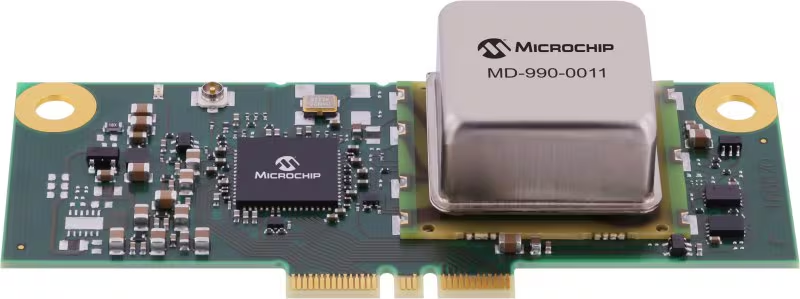
Microchip Technology has released its MD-990-0011-B family of plug-in timing modules, delivering turnkey, high-precision synchronization for data center servers and 5G virtualized radio access networks (vRAN).
Developed in collaboration with Intel, the MD-990-0011-B timing module is designed for seamless compatibility with Intel Xeon 6 SoC-powered server platforms, supporting both OEMs and ODMs in building future-ready systems. By leveraging Intel’s foundational vRAN architecture, the module enables robust, low-latency time synchronization, which is essential for distributed AI workloads and real-time applications.
Engineered for the reliability and scalability required by cloud infrastructure, virtualization and high-availability deployments, the MD-990-0011-B supports automatic source selection and locking across GNSS, synchronous Ethernet (SyncE) and precision time protocol (PTP). This flexibility supports continuous, accurate timing even as network demands evolve.
The MD-990-0011-B timing modules are available in two variants. MD-990-0011-BC01 offers eight hours of holdover performance; MD-990-0011-BA01 offers four hours of holdover performance. These timing modules consolidate several of Microchip’s advanced technologies into a single, highly integrated solution. Key components include:
Synchronous Ethernet (SyncE) synthesizer (ZL80132B). Two independent digital phase-locked loop (DPLL) channels for flexible and resilient synchronization
Oven controlled crystal oscillators (OCXOs, OX-22x). Provide up to eight hours of holdover, ensuring stable timing during GNSS outages or network disruptions
MCP9808 temperature sensor. Supports enhanced, environmental monitor 24LC024 EEPROM implementing board configuration and VC-820for low jitter performance
By unifying these critical timing components into a single plug-in module, the MD-990-0011-B streamlines server architecture, reduces design complexity and simplifies the supply chain. Its modular design enables rapid installation and simplified maintenance, minimizing downtime and facilitating effortless upgrades, key advantages for dynamic data center and 5G network environments.
In 2020, OCP-TAP started working on highly precise and hyper-scalable time synchronization services in its data center market, using a GNSS clock source and precision time protocol (PTP) technologies. OCP-TAP technology adds scalability and improves the accuracy of timekeeping within the infrastructure industry.
In 2021, OCP-TAP integrated its technology into the time card and introduced it as an open-source solution to build time servers.
The Protempis Res720 embedded module provides a highly accurate GNSS clock source to further increase the accuracy, resiliency and adoption of the OCP-TAP’s new time card duo, which was announced in an OCP Tech Talk on June 2.
OCP-TAP provides a new collaborative community focused on designing hardware and software to efficiently support critical timing accuracy and resiliency demands on computer network infrastructure.
Protempis Res720
Protempis’s Res720 embedded module adds a dual-band GNSS time reference to the time card to improve resilience, noise rejection and anti-spoofing and anti-jamming capabilities.
The Res720 GNSS embedded timing module is suitable for data centers, 5G Open RAN and XHaul, smart grids, industrial automation and SATCOM networks. It provides 5 ns timing accuracy, dual-band GNSS support and anti-jamming/anti-spoofing capabilities.
The Res720 embedded module provides unparalleled performance as a timing source in embedded systems, including to time servers, network interface cards, radio units and routing/switching devices for 5G, private wireless, Open RAN and data networks.
“Protempis brings its expertise in GNSS and network synchronization to Meta, the OCP-TAP, and the open-sourced time card. Their highly accurate dual-band GNSS product has shown how it can improve operations,” said Ahmad Byagowi. Byagowi is inventor of the Time Card, founder and project lead for OCP-TAP, and a research scientist at Meta.
“We are honored that our Res720 dual-band technology will be used for enabling time-sensitive applications over OCP-compliant and PTP-aware networks,” said Karen Guldan, Protempis president. “We look forward to a continuing partnership with OCP-TAP and global network leaders working to advance solutions to provide ongoing timing accuracy and resilience.”
Precisional, an affiliate of The Jordan Company (“TJC”), announced May 9 that it completed the previously announced transaction to acquire four industrial technology businesses from Trimble, including Protempis (formerly Trimble Time and Frequency).
A roundup of recent products in the GNSS and inertial positioning industry from the July 2021 issue of GPS World magazine.
OEM
GNSS/INS Sensors
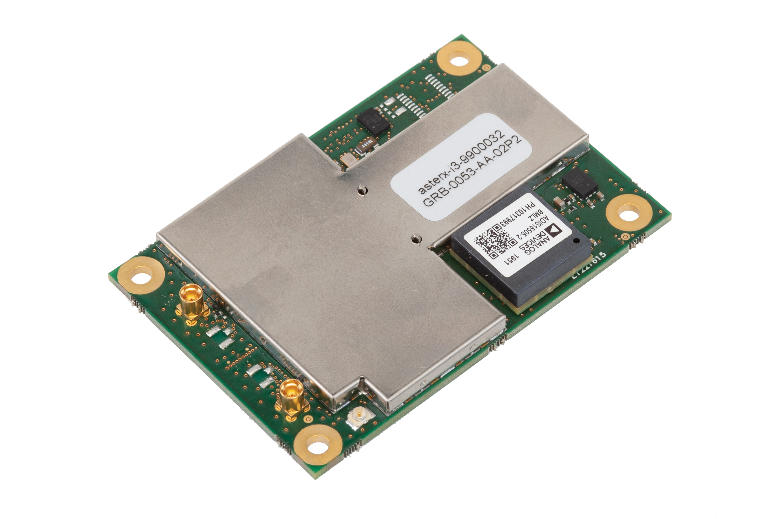
Photo: Septentrio
Five receivers in new product line
The AsteRx-i3 product family provides an array of next-generation receivers, from plug-and-play navigation solutions to feature-rich receivers with raw measurement access. Included are OEM boards and ruggedized receivers enclosed in a waterproof IP68 housing. The Pro receivers offer high accuracy positioning with 3D orientation and dead-reckoning for plug-and-play integrations. Pro+ receivers provide integrated positioning and orientation along with raw measurements, in single- or dual-antenna configurations, suitable for applications with sensor fusion. One of the receivers offers an off-board inertial measurement unit (IMU), which can be mounted exactly at the alignment point of interest.
The RES 720 GNSS dual-frequency embedded timing module provides next-generation networks with 5-nanosecond accuracy. It uses L1 and L5 GNSS signals to provide superior protection to jamming and spoofing, mitigates multipath in harsh environments, and adds security features to make it suitable for resilient networks. At 19 x 19 millimeters, the RES 720 is suitable for 5G Open Radio Access Networks (RAN)/XHaul, smart grids, data centers, industrial automation and satellite communication networks, as well as calibration services and perimeter monitoring applications.
The new HG1125 and HG1126 IMUs are low-cost inertial measurement units that serve both commercial and military applications. They use sensors based on micro-electromechanical systems (MEMS) technology to precisely measure motion. They can survive shocks up to 40,000 G-force. The HG1125 and HG1126 can be used for a variety of defense and commercial applications, such as tactical military needs, drilling, unmanned aerial vehicles or navigation systems for general aviation aircraft.
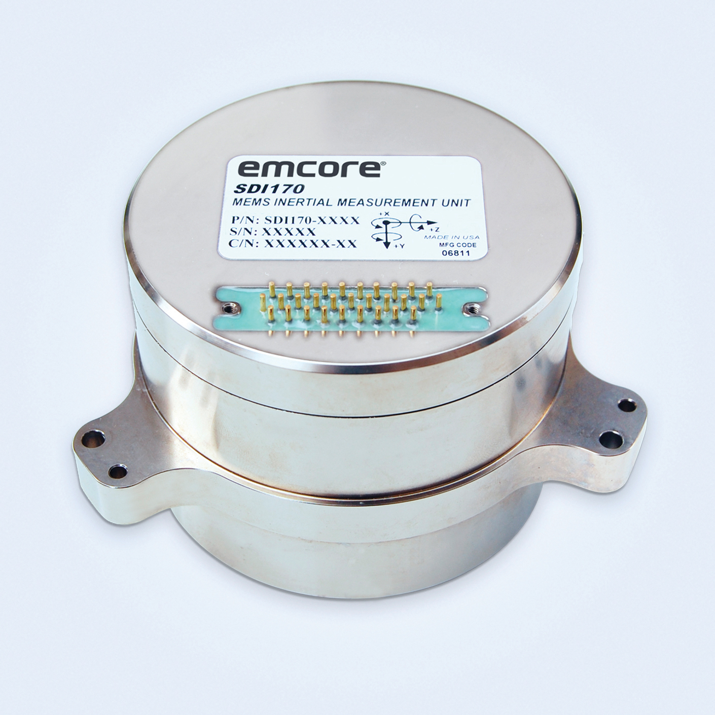
The SDI170 quartz MEMS tactical-grade IMU is designed as a form-, fit- and function-compatible replacement for the HG1700-AG58 ring-laser gyroscope (RLG) IMU, but with superior overall performance, versatility and a significantly higher mean time between failures (MTBF) rating over ruggedized environments. The SDI170 IMU delivers highly linear accelerometer performance and longer life compared to the HG1700 IMU.
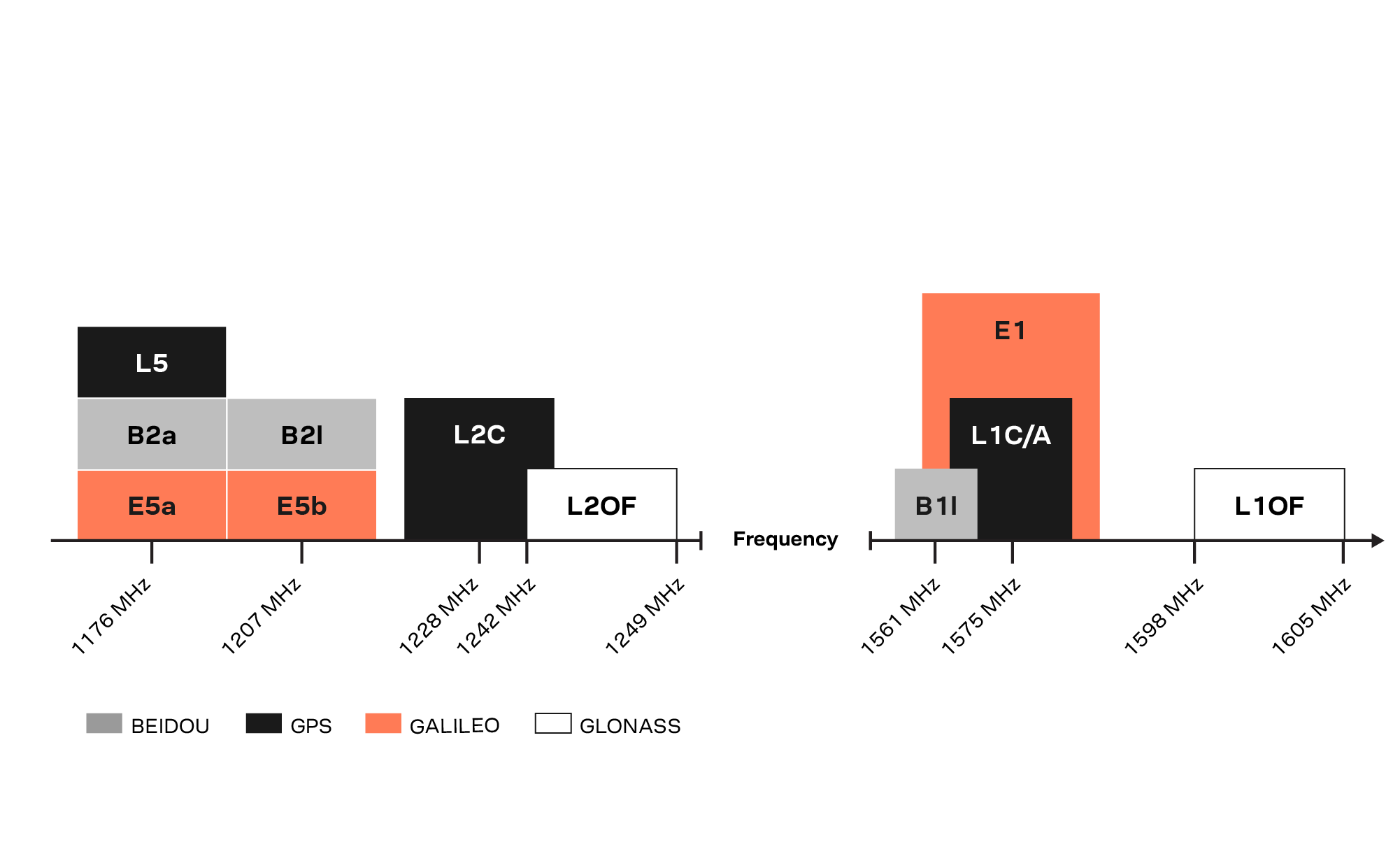
The OSA 5405-MB is a compact outdoor precision time protocol (PTP) grandmaster clock with a multi-band GNSS receiver and an integrated antenna. It ensures timing accuracy by eliminating the impact of ionospheric delay variation, enabling communication service providers and enterprises to deliver the nanosecond precision needed for 5G fronthaul and other time-sensitive applications. A multi-constellation GNSS receiver and antenna enable the OSA 5405-MB to meet PRTC-B accuracy requirements (+/–40 nanoseconds) even in challenging conditions. It receives GNSS signals in two frequency bands, using the differences between them to calculate and compensate for ionospheric delay variation. The OSA 5405-MB is resilient against jamming and spoofing, considered critical for 5G synchronization. It can work with up to four GNSS constellations concurrently (GPS, Galileo, GLONASS and BeiDou).
The Toughbook S1 is a fully rugged 7-inch Android tablet for capturing and accessing critical information in the field. GPS and LTE come optionally. The tablet is supported by Productivity+, a comprehensive Android ecosystem that enables customers to develop, deploy and sustain the Android OS environment in the enterprise. The Toughbook S1 tablet’s compact, rugged and lightweight body is made for portability and reliability for field workers. It has a 14-hour battery life and warm swap battery. Features include a sleek outdoor-readable anti-reflection screen, patented rain mode and multi-touch performance whether using a stylus, finger or glove.
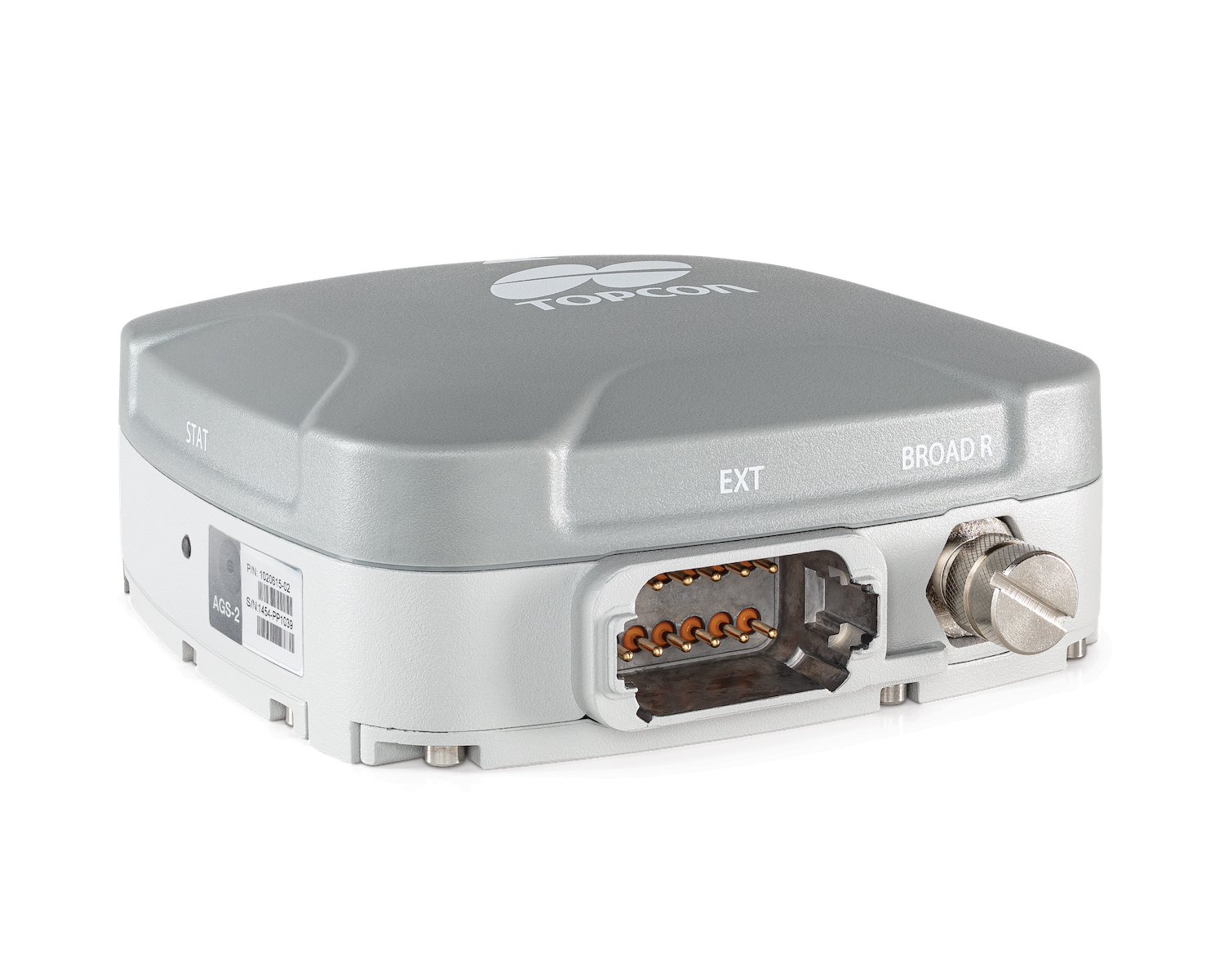
The AGS-2 and AGM-1 are manual guidance and autosteering receivers. Location data enable crop optimization, including soil preparation, seeding, crop care and harvesting. Designed to suit virtually any agricultural machine type, make and model, the AGS-2 receiver and steering controller combines steering with network reception and tracking. It comes standard with DGNSS correction services and is upgradeable using NTRIP and an optional RTK radio in the Topcon CL-55 cloud connectivity device. The AGM-1 is offered as an economical entry-level manual-guidance receiver.
Provides fast data processing for construction and surveying
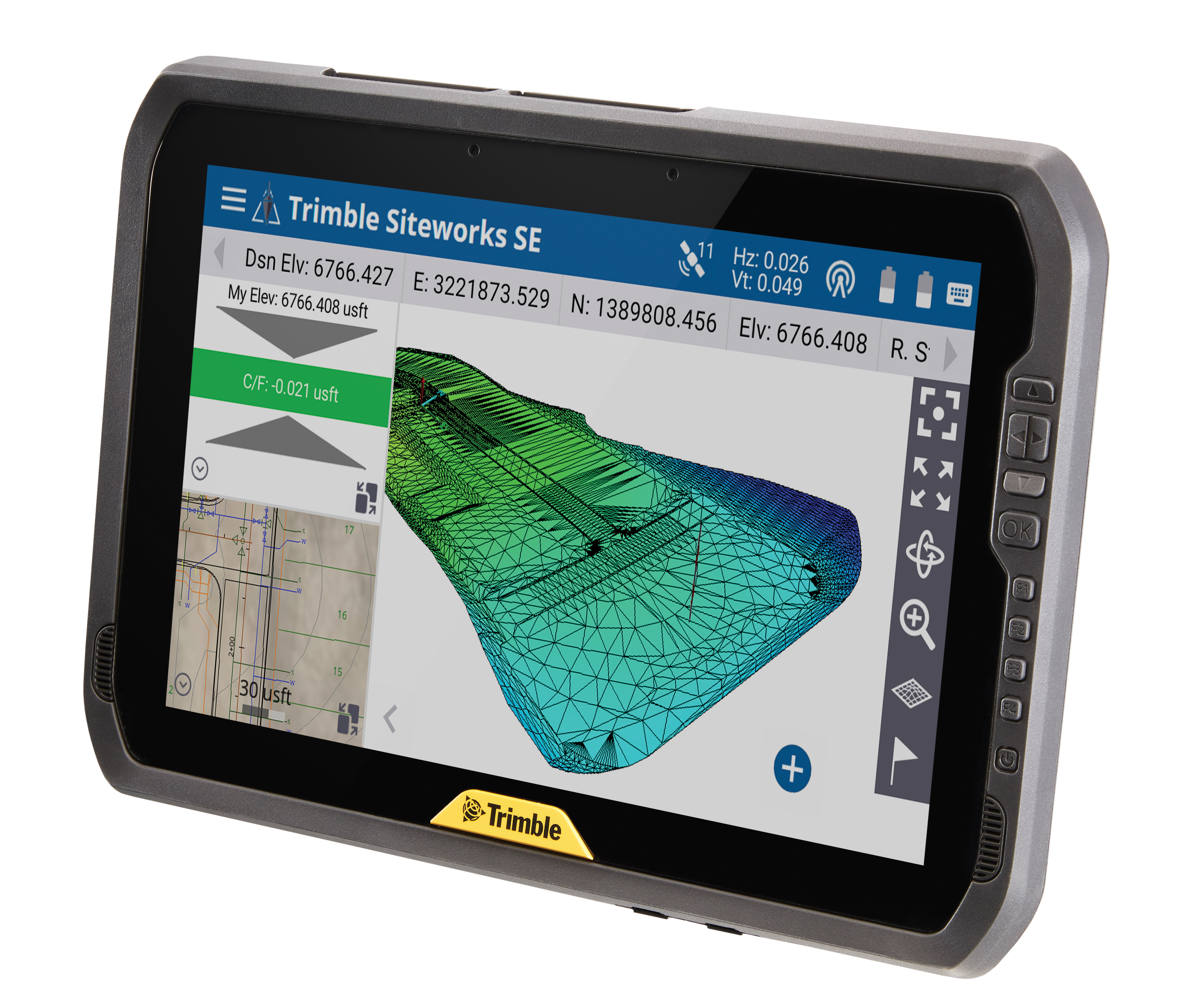
The Trimble T100 high-performance tablet is suitable for both experienced and novice users. It is optimized for Trimble Siteworks Software and supporting office applications such as Trimble Business Center. Its accessories are designed to complement user workflows, enabling users to complete quality assurance and quality control before leaving the field. The tablet is designed to be flexible and usable in a variety of configurations and job sites. It is engineered to be ergonomic and portable on and off the pole. Features include a 10-inch (25.4 cm) sunlight-readable touchscreen display, a directional keypad with programmable function keys and a 92-Wh internal battery.
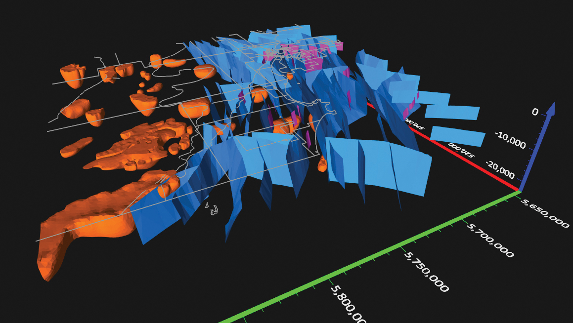
Surfer has new gridding, contouring and surface mapping software to make it easier for users to visualize, display and analyze complex 3D data. Surfer enables users to model data sets, apply an array of advanced analytics tools, and graphically communicate the results. The scientific modeling package is used in oil and gas exploration, environmental consulting, mining, engineering and geospatial projects. Enhancements have been made to 3D Base Maps, Contour Volume/Area Calculation, 3D PDF Exporting Options and automated features for creation of scripts and workflows.
A Catalyst-AWS collaboration delivers actionable geoscience analytics to users, providing satellite-based Earth observation intelligence. The data and analytics are delivered via Amazon Web Services (AWS) Cloud. Catalyst is a PCI Geomatics brand. The initial solution, available through AWS Data Exchange, is an infrastructure risk-assessment service that uses satellite data to continuously monitor millimeter-level ground displacement over a subscriber’s area of interest anywhere on Earth. Catalyst is exploring additional risk mitigation solutions and monitoring services using AWS. Having image processing science and imagery on the cloud reduces latency and costly data transfers.
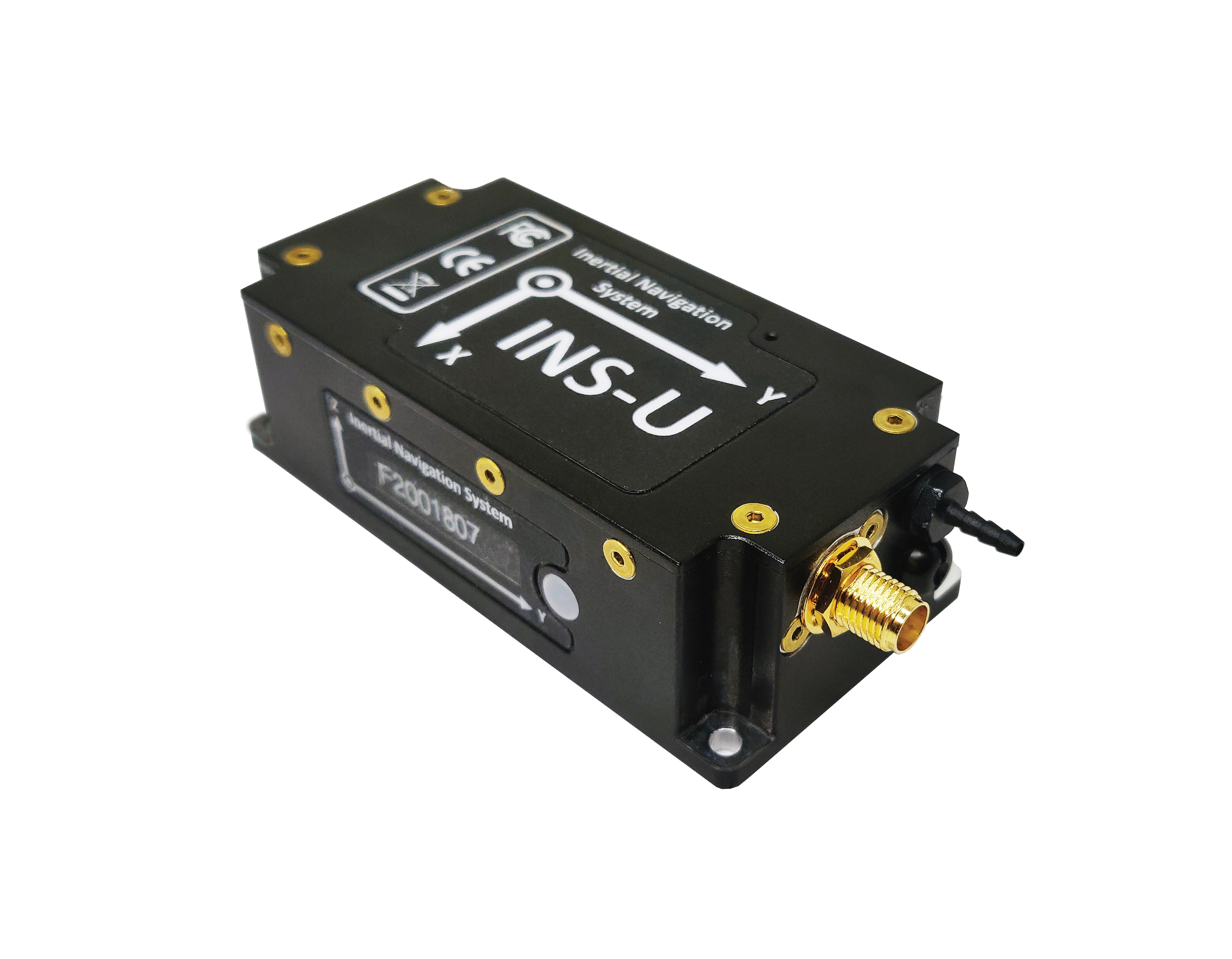
The GPS-aided INS-U is a fully integrated attitude and heading reference system (AHRS), IMU and air-data computer high-performance strapdown system that determines position, navigation and timing information for any device on which it is mounted. The INS-U uses a single antenna, multi-constellation u-blox GNSS receiver. With access to GPS, GLONASS, Galileo, QZSS and BeiDou, the INS-U can be used in a variety of GPS-enabled environments and is protected against spoofing and jamming. The INS-U has two barometers, a miniature gyro-compensated fluxgate compass, and tri-axis temperature-calibrated advanced MEMS accelerometers and gyroscopes. These high-performance sensors, along with Inertial Labs’ new on-board sensor-fusion filter, and state-of-the-art guidance and navigation algorithms, provide accurate position, velocity and orientation of the device under measurement.
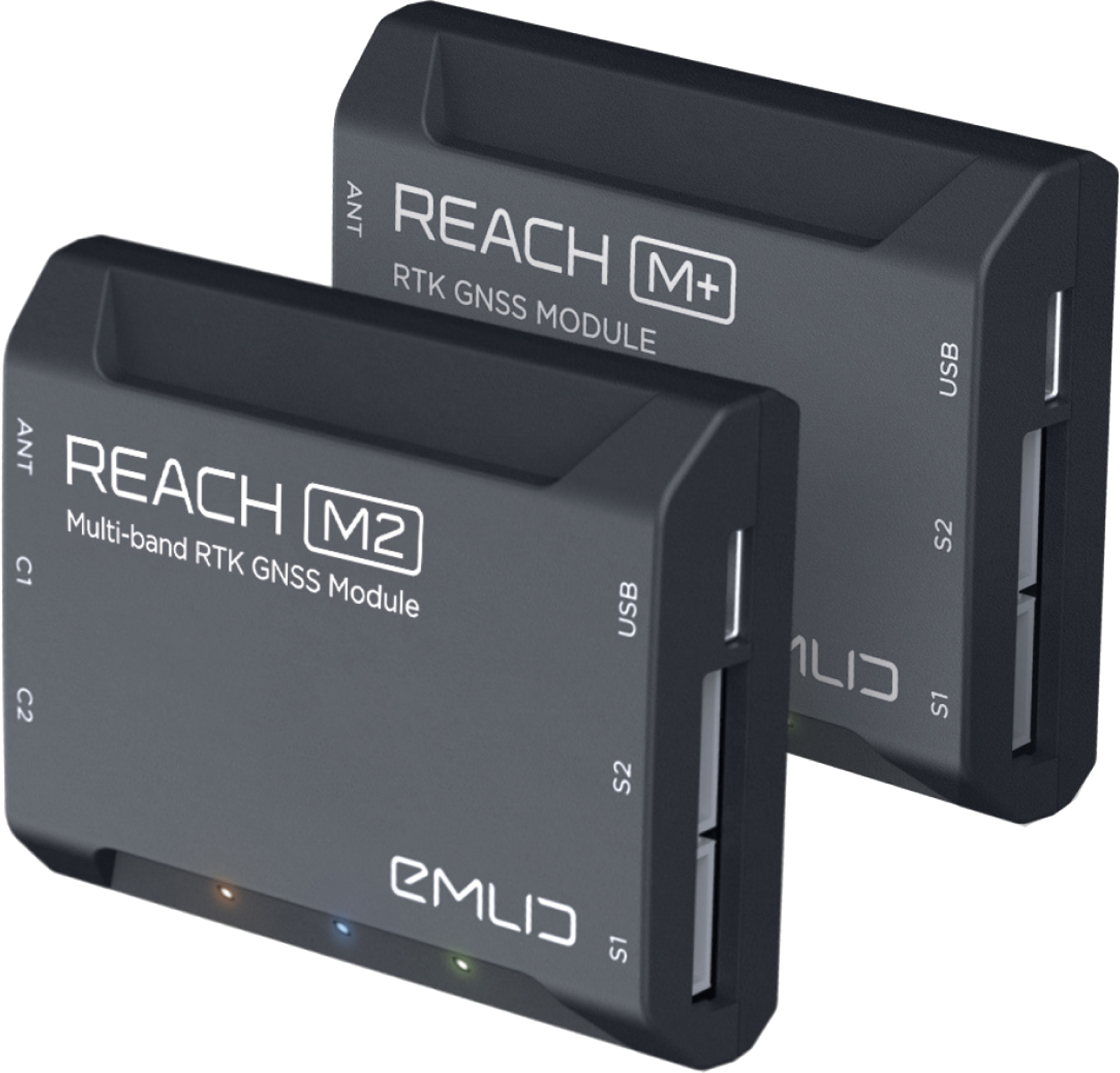
The Reach M+ and Reach M2 positioning modules for UAV mapping provide centimeter-level accuracy in real-time kinematic (RTK) and post-processed kinematic (PPK) modes, enabling precise UAV mapping with fewer ground control points. The Reach M+ single-band receiver has a baseline up to 20 kilometers in PPK. The Reach M2 is a multi-band receiver with a baseline up to 100 kilometers in PPK. Reach connects directly to a camera’s hot-shoe port and is synced with the shutter. Time and coordinates of each photo are logged with a resolution of less than a microsecond. Reach captures flash sync pulses with sub-microsecond resolution and stores them in a raw data RINEX log in the internal memory. This method allows ground control points to be used only to check accuracy.
System simplifies drone inspection missions, deliveries
The Dronehub is an automated solution that can provide undisturbed drone service 24/7 in nearly any weather condition. With the integration of IBM artificial intelligence technology, Dronehub solutions can operate and automatically provide information with little human interaction. The system includes the drone and a docking station with automatic battery replacement. It can fly for 45 minutes in +/–45° C weather, up to 35 km in winds up to 15 m/s. It can carry a payload up to 5 kg as far as 15 km. It can be used for monitoring, inspection and measurement; cargo transport and parcel deliveries; and mobile ground infrastructure; and security.
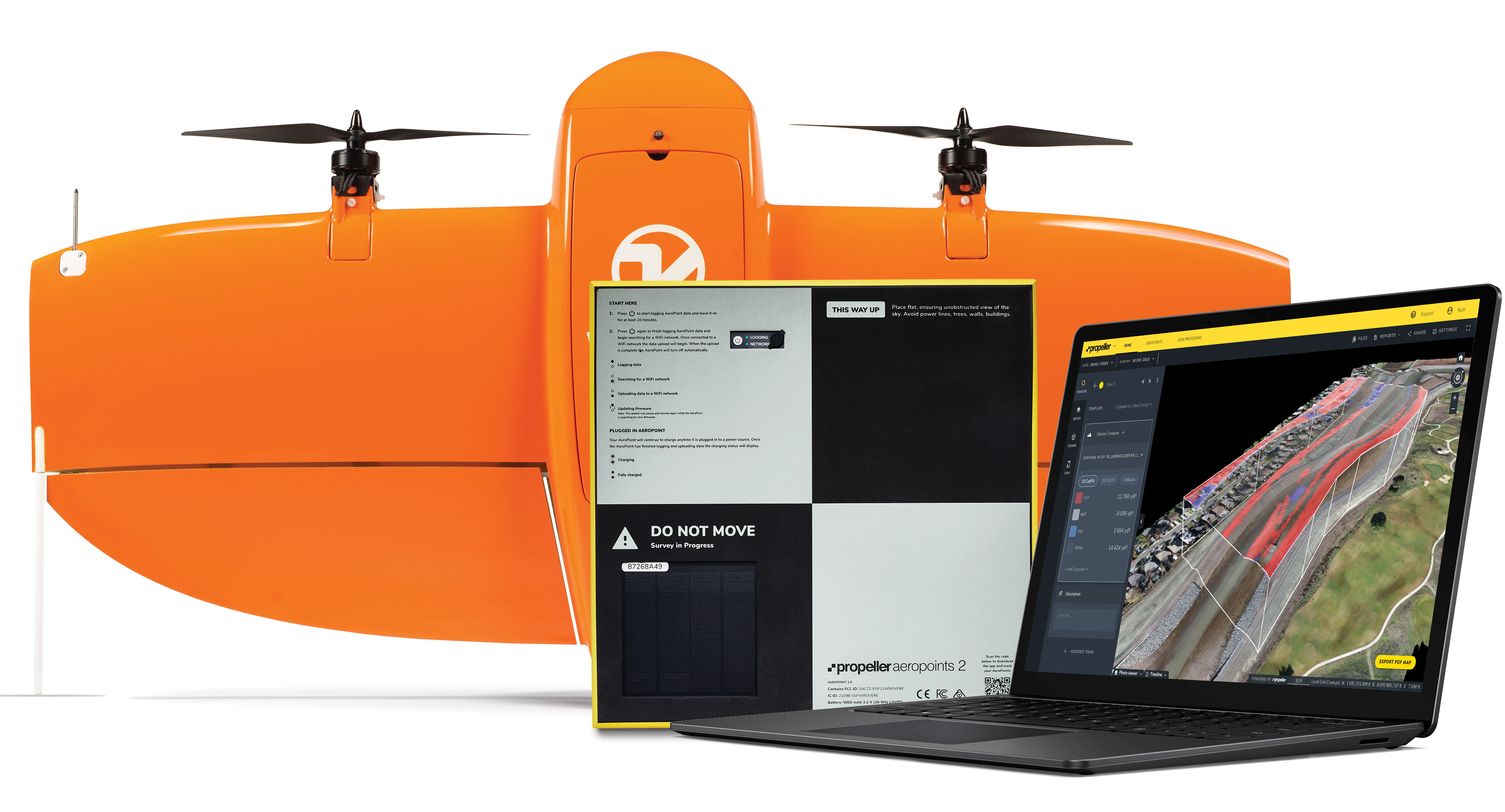
The Propeller Platform and WingtraOne drone package enable construction professionals to collect survey-grade data across the worksite consistently and accurately. To operate, surveyors place Propeller AeroPoints (smart ground-control points) on their worksite, and then fly the WingtraOne drone to collect worksite survey data. Survey images are uploaded to Propeller’s cloud-based platform, where the fully automated geotagging and photogrammetry processing is completed within 24 hours of submission on the platform. Uses include mines, road and railway projects, highways and industrial complexes. Data collection with AeroPoints and Propeller PPK can serve as a reliable, single source for survey data and progress. Teams across the entire worksite can view geographically accurate and realistic 3D site models and track, inspect and report on job progress and productivity safely and accurately.
Stamp-sized module provides RTK positioning and heading
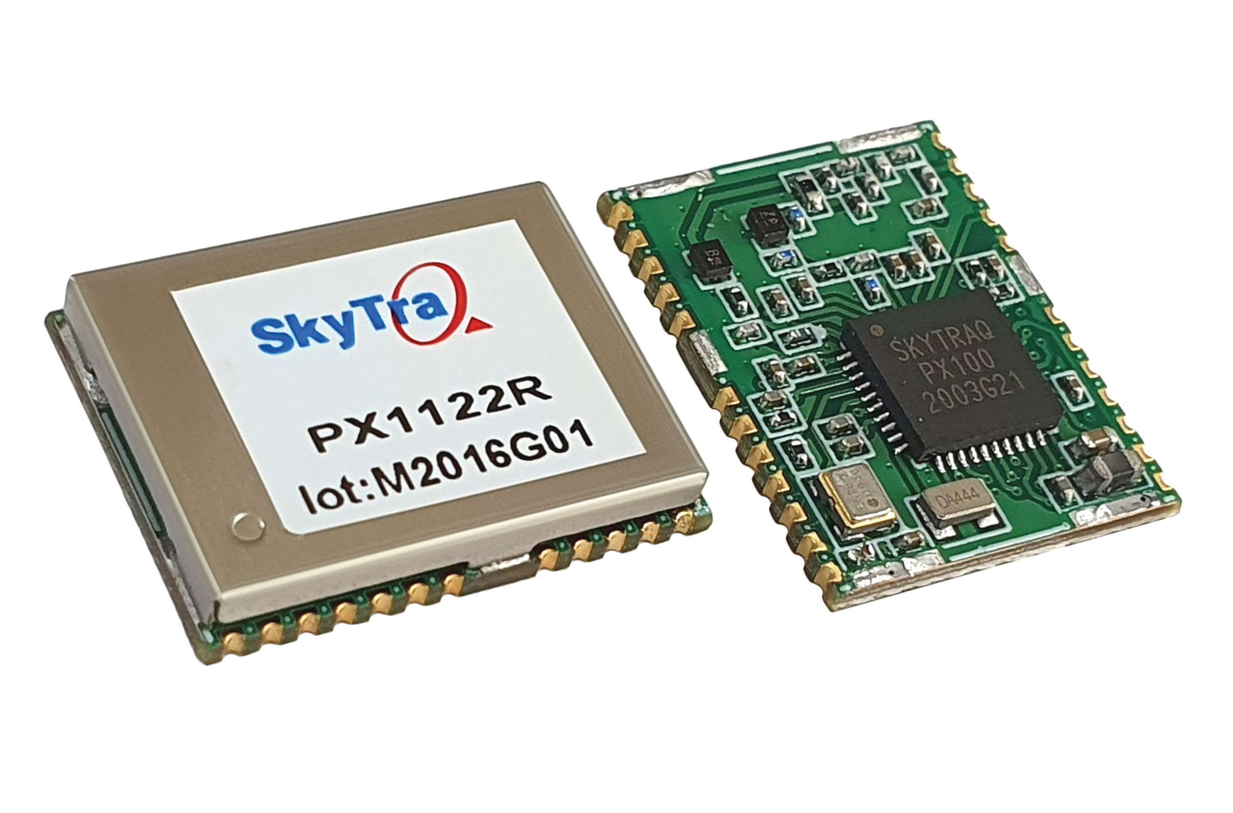
The PX1122R is a high-performance multi-band quad-GNSS real-time kinematic (RTK) receiver featuring 1 cm + 1 ppm position accuracy and under 10-second RTK convergence. It has a 12 x 16 millimeter form factor, about the size of a postage stamp. It can be configured for a base or a rover, and supports a moving base RTK for precision heading applications. The PX1122R has a maximum quad-GNSS RTK update rate of 10 Hz, providing a quick response time and more stable performance for fast-moving precision guidance applications.
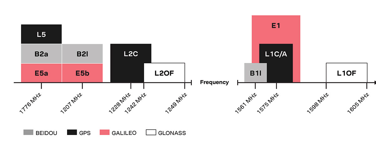
Utilizing both L1 and L5 GPS frequencies, along with multi-constellation support (GPS, Galileo, GLONASS and BeiDou), the MSC 10 marine satellite compass provides precise positioning and heading accuracy within 2 degrees. Its 10-Hz position update rate delivers detailed tracking information. It eliminates magnetic interference, which can degrade heading accuracy. The MSC 10 is easy to install and can be used as the primary position and heading sensor across multiple systems, including autopilots. If the satellite signal is lost, it will transition from GPS-based to a backup magnetometer-based heading.
New modules enable users to develop high-precision solutions for heavy machinery, ground robotics, and unmanned aerial vehicles (UAVs).
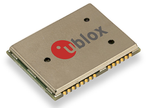
U-blox’s latest multi-band high-accuracy timing modules concurrently support L1 and L5 GNSS signals. The ZED-F9T-10B and LEA-F9T-10B timing modules, and the RCB-F9T-1 timing card, deliver nanosecond-level timing accuracies required to synchronize cellular network base stations and smart power grids. The ANN MB1 L1/L5 multi-band antenna completes the offering.
The multiband capability compensates for ionosphere error from all GNSS satellite constellations and reduces the timing error under clear skies to less than 5 ns without the need for an external GNSS correction service. To achieve maximum performance, the modules track signals from as many satellites as possible.
Image: u-blox
With satellite constellations transmitting signals on the L5 band nearing completion, the L1/L5 signal combination is becoming a viable option to complement products based on L1 and L2 signals. Modernized L5 signals are expected to deliver improved performance, especially in difficult urban conditions. Because L5 signals fall within the protected aeronautical radionavigation service (ARNS ) frequency band, they are also less subject to RF interference.
The LEA-F9T-10B provides a temperature range extended to –40 to +105° C. Both timing modules include a suite of advanced security features, including:
Improved anti-jamming and anti-spoofing technologies detect and flag malicious RF interference.
Secure boot ensures that the modules can only boot with authentic firmware.
Secure interfaces prevent intruders from tampering with the messages between the receiver and the host system.t
The ANN-MB1 L1/L5 multi-band antenna supports the GPS, GLONASS, Galileo and BeiDou, and addresses the scarcity of options in the nascent L1/L5 high-precision antenna mass-market, simplifying testing and deployment of L1/L5 multi-band GNSS solutions. Magnetic and fixed mounting options help meet diverse installation needs.
The new products targets developers in industrial navigation and robotics interested in high-precision positioning technology to locate UAVs, ground robots and agricultural equipment accurately and in real time.
Engineering samples of the u-blox ZED-F9T-10B, RCB-F9T-1 and ANN-MB1 will be available in May, followed by the LEA-F9T.
Dual-frequency timing module provides anti-jamming and anti-spoofing capabilities
Photo: Trimble
Trimble has introduced its first dual-frequency embedded timing module that provides next-generation networks with 5-nanosecond accuracy.
Surface mountable, the Trimble RES 720 GNSS timing module can be integrated into network equipment. It uses L1 and L5 GNSS signals to provide superior protection to jamming and spoofing, mitigates multipath in harsh environments, and adds security features to make it suitable for resilient networks.
Precise timing and synchronization optimizes and improves wireless network performance. At 19 x 19 millimeters, the RES 720 module provides a low-cost, easy-to-use, highly accurate and reliable GPS timing source for critical infrastructure in a broad range of industries. The RES 720 is suitable for 5G Open RAN/XHaul, smart grids, data centers, industrial automation and satellite communication networks, as well as calibration services and perimeter monitoring applications.
The RES 720 meets the resilient timing requirement mandated by the U.S. 2020 Executive Order (EO13095) for timing services and critical infrastructure operators. Using dual-frequency (L1 and L5), RES 720 provides better multipath detection capabilities than single frequency, and provides protection against signal jamming and spoofing. Multi-band capability helps compensate for the ionospheric error from multi-GNSS satellite constellations, while reducing the timing error under clear skies to less than 5 nanoseconds. To further improve its accuracy locally, the RES 720 module features differential timing modes for highly accurate local timing.
Powered by Trimble’s Smart GNSS Assurance technology, the RES 720 offers protection against jamming and hacking of signals with automatic fallback to available GNSS signals. Infrastructure equipment suppliers, system integrators and network operators can benefit by integrating highly accurate synchronization capabilities into their network and synchro-phasor devices, while enabling resilient timing for critical infrastructure.
The RES 720 is expected to be available in the second quarter of 2021.
u‑blox has announced the NEO-M8T and LEA-M8T precision timing modules, which are able to generate a precise reference clock with <20 ns accuracy. The receivers offer high sensitivity (-157 dBm signal acquisition with assisted GNSS) that allows quick start-up inside structures with limited sky view. The precise reference clock is derived from multi-GNSS including GPS, GLONASS, and BeiDou.
The LEA-M8T module is footprint compatible with existing LEA-5T/6T designs, facilitating easy upgrade. The NEO-M8T is optimized for timing applications requiring low power consumption and long battery life such as geophones used for seismic field measurements. Both compact, surface-mount modules meet stringent requirements for reliability, accuracy and low power consumption.
“These new modules are the industry’s highest performance GNSS timing modules in terms of accuracy, reliability and power consumption,” said Thomas Nigg, Vice President of Product Marketing at u-blox, “The new modules are perfect solutions for mission-critical infrastructure systems including mobile communication networks, power generation and distribution systems and seismic measurements.”
The NEO and LEA-M8T modules are multi-GNSS, pin-compatible successors to u-blox’ existing PPS timing modules and complements the previously announced GNSS disciplined frequency reference module, LEA‑M8F.
Measuring 12.2 x 16.0 mm (NEO-M8T) and 17.0 x 22.4 mm (LEA-M8T), the modules deliver high integrity and reliability with RAIM (Receiver Autonomous Integrity Monitoring) and alarms, which are crucial features for extremely reliable operation. Two time-pulse outputs are available, configurable from once per minute up to 10 MHz. The modules also output multi-GNSS RAW data including carrier phase, code phase and pseudo-ranges.
The modules can deliver time according to any international standard including calibration of inter-constellation offsets. Survey-in and single satellite timing features increase timing accuracy and timing availability with as few as one single satellite in view. Support for low duty cycle operation reduces power consumption for battery-powered applications which results in cost savings as smaller batteries can be used.
The M8T timing modules are delivered in u-blox’ established LEA and NEO form-factors with standardized pin-out, allowing ready migration from previous product generations. u-blox timing products can make optional use of u-blox AssistNow or industry standard aiding data. This reduces the time to first fix and delivers exceptional acquisition sensitivity, even on first installation before precise location or time is known.
Swiss-based u‑blox has unveiled the LEA-M8F precision timing GNSS module. The compact, surface-mount module generates a precise 30.72 MHz reference clock crucial for synchronizing industrial data and communication systems such as small, femto and macro-cell mobile networks. High accuracy is achieved by disciplining a local oscillator or other clock source with timing signals received from satellite-hosted atomic clocks.
To ensure satellite availability, LEA-M8F is able to acquire and track all 50+ GPS, GLONASS and BeiDou satellites. High sensitivity enables quick autonomous start-up even inside structures with limited sky-view.
“A reliable, compact and cost-effective precision reference clock is a crucial component used in many systems in the Critical Infrastructure and Key Resource sectors (CIKR),” said Thomas Nigg, vice president of product marketing at u-blox. “Our LEA-M8F GPS/GNSS satellite-disciplined timing module enables the proper operation of many mission-critical infrastructure systems including mobile and fixed-line communication networks, power generation and distribution systems, gas and chemical processing plants, banking, postal and goods distribution processes.”
Measuring 17 x 22 mm, the LEA-M8F module includes a low-noise 30.72 MHz VCTCXO (voltage and temperature controlled oscillator), meeting the master reference requirements for LTE Small Cells while providing 100 parts-per-billion autonomous hold-over accuracy. The module is also suitable for TD-LTE, LTE-Advanced and other applications requiring extended hold-over times when integrated with small cell platforms.
External sources of synchronization are supported through time-pulse and frequency inputs and a message interface. This allows measurements from macro-sniff, Sync-E or packet timing to be combined with measurements from GNSS to extend the availability of accurate synchronization and in doing so maximize cellular service availability.
LEA-M8F can track signals from satellites from any two constellations simultaneously (e.g. GPS and GLONASS, GPS and BeiDou, GLONASS and BeiDou). Compatibility with multiple GNSS systems gives the LEA-M8F access to a large number of satellites, allowing synchronization even in urban or indoor areas with limited sky view. For stationary applications, once a location is known, accurate timing can be maintained based on the signal from just a single satellite.
For more information, download the u-blox whitepaper “GNSS Timing and the Rise of Small Cells”. Detailed information about the LEA-M8F and evaluation kit EVK-M8F can be found on the u-blox website. Samples of the LEA-M8F will be available in Q1 2014.
Also, the LEA-M8F will be demonstrated at the Small Cells Americas exhibition in Dallas, Dec. 3-4, at u-blox stand number 3.