Tag: topographic survey

  • ComNav Technology and Dominican Republic forge advanced CORS network

    ComNav Technology and Dominican Republic forge advanced CORS network

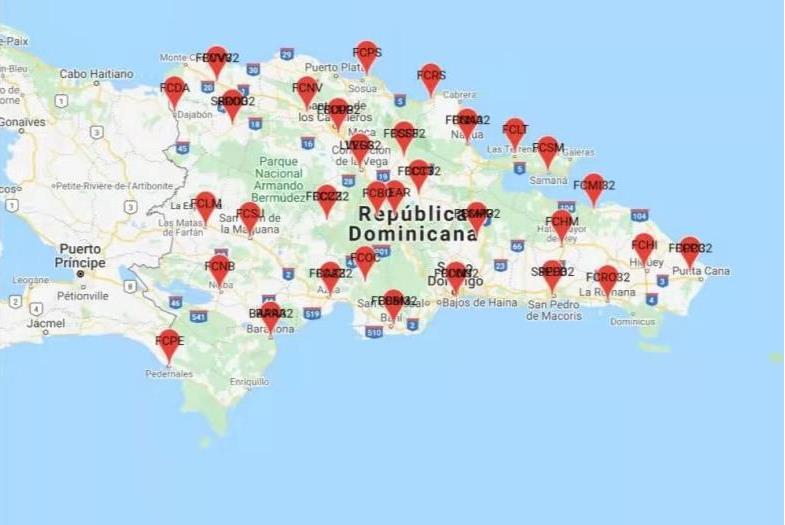
    ComNav Technology has collaborated with FUNDCORSRD, a non-profit institution, to establish a comprehensive network of continuous reference stations (CORS) across the Dominican Republic for conducting topographic surveys.

    As a result of this collaborative effort, there are now 32 CORS stations spread throughout the Dominican Republic that are fully implemented with the SinoGNSS CORS solution from ComNav.

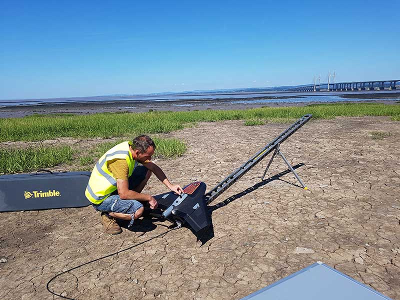
    ComNav Technology’s choice of equipment for this project included the M300 Pro GNSS receivers and AT600 choke ring antennas for the CORS reference stations.

    The M300 Pro features robust satellite tracking capabilities, supporting multiple satellite constellations such as GPS, GLONASS, BeiDou, Galileo, SBAS, L-band, and QZSS. It also comes equipped with a built-in web server, interfaces for external devices, a user-friendly front panel display, optical fiber interface, and a secure TF-card with password protection.

    The AT600 high-performance choke ring antenna features high gain, accuracy, and reliability, along with full-constellation compatibility.

  • U.K. UAV surveying company creates specialized solution for rail clients

    U.K. UAV surveying company creates specialized solution for rail clients

    Image: Plowman Craven
    Image: Plowman Craven

    Plowman Craven, a United Kingdom-based aerial surveying company, has launched the Vogel Freedom UAV data collection solution designed for owners and operators of rail networks.

    The Vogel Freedom UAV solution aims to solve issues rail operators face in carrying out network surveys, including traffic disruptions and dangers created for workers needing access to infrastructure for ground point sensors.

    The platform requires fewer ground points to deliver topographical surveys. It can also produce sub-5 mm accurate rail system models using off-track sensor placement.

    Operating from offices in London and Hertfordshire, Plowman and Craven is one of the largest infrastructure surveying and inspection businesses in the U.K.

    “We developed Vogel Freedom in response to ever-increasing industry challenges and needs,” Steve Jones, head of new business at Plowman Craven, said. “It removes previous limitations to surveying and can add substantial value… all while improving workers’ safety and ensuring a safe and efficient rail service for customers.”

  • Pilot project analyzes climate change for Caribbean nations 

    Pilot project analyzes climate change for Caribbean nations 


    Image: TommL/E+/Getty Images
    Image: TommL/E+/Getty Images

    NV5 Geospatial has forged a contract with the Caribbean Community Climate Change Center (CCCCC) to conduct aerial lidar and orthoimagery surveys across the Caribbean. The pilot project will provide advanced geospatial data to help the island nations understand natural and man-induced climate changes, develop programs to support resilience and sustainable development, and establish a foundation for future work.

    NV5 Geospatial will conduct topographic and topobathymetric lidar surveys, as well as orthoimagery, via a fixed-wing aircraft. Data collected will help CCCCC address the impact of climate variability and identify potentially hazardous impacts.

    The project will cover 10 sites spread across more than 3,000 km. The sites include areas in Suriname, Guyana, Tobago, Barbados, St. Vincent and the Grenadines, Saint Lucia, Antigua and Barbuda, St. Kitts and Nevis, Turks & Caicos and Belize.

    Other logistical considerations include the combination of microclimates inherent around tropical islands, highly variable weather conditions, cloud formations and jungles, some of which are in high relief areas or covering the entire area.

  • ComNav Technology: Surveying in urban conditions

    ComNav Technology: Surveying in urban conditions

    A surveyor in Burkina-Faso surveys the site of a new hospital for infectious diseases. (Photo: ComNav)
    Surveyors used ComNav equipment to construct a hospital in Burkina Faso. (Photo: ComNav)

    Line of sight to GNSS satellites is sometimes obscured by buildings and trees, which also cause multipath, as does nearby water. These conditions require an RTK receiver with multipath mitigation. Often, surveying must occur on property corners or on uneven ground, where it is hard to place surveying equipment. For these reasons, reliability and accuracy are essential, especially in harsh environments. Ground control points require 1-2mm accuracy and topo surveys 1-2cm accuracy. Surveying for AEC also requires software that processes digital files.

    ComNav has focused on GNSS core technology innovation and applications for 10 years. The Quantum III technology includes algorithms to suppress multipath and supports all GNSS constellations, allowing the users to acquire and keep RTK centimeter accuracy even in harsh environments. The built-in tilt IMU will help where the exact location to be surveyed is hard to reach. For example, the T300 Plus and N Series GNSS receivers support a maximum pole tilt of 60° and keep the compensation accuracy within 2.5cm, making the field work more efficient, convenient and reliable.

    With the Survey Master software’s stake-out points, users can import DXF or DWG files directly and the software can stake out the point, line and surface in CAD.

    In April 2021, the government of Burkina Faso used ComNav GNSS T300Plus to provide ground control points survey for the construction of a hospital.

    The land security and topographic surveying were completed within only six days, less than half the time that had been scheduled for those tasks. This greatly expedited the construction of the hospital and helped with the fight against infectious diseases, including COVID-19.  

  • AG Surveys collects topographic beach surveys throughout England

    AG Surveys collects topographic beach surveys throughout England

    Prepping for flight: Andreas Garbe, AgSurvey, sets up the UX5 HP for a topographic survey at Severn Beach, a village in South Gloucestershire. (Photo: Trimble)
    Prepping for flight: Andreas Garbe, AgSurvey, sets up the UX5 HP for a topographic survey at Severn Beach, a village in South Gloucestershire. (Photo: Trimble)

    Based in Bristol, AG Surveys has been collecting topographic beach surveys around the country as part of England’s Environment Agency’s coastal monitoring campaign.

    In the first integrated approach of its kind in the program, AG Surveys uses the Trimble UX5 unmanned aerial system (UAS) equipped with a Trimble/Applanix GNSS receiver along with photogrammetry software. The UAS-based system has not only confirmed its viability for coastal monitoring, it has been bringing new business opportunities ashore since 2017.

    For each beach, AG Surveys must provide one baseline survey based on a 5-meter grid with a height accuracy of 3 centimeters. Also required is a series of profile line surveys. Profile surveys follow pre-defined lines set every 50 meters from the back of the beach to the low tide line, with GNSS measurements taken within 10 centimeters of each side of the line.

    Crews typically cover 3 square kilometers a day, flying four to five Delair drone flights at an altitude between 100–120 meters, at speeds of 80 kph and a lateral overlap of 80%. To ensure the reliability and accuracy of the UAS data, they use a minimum of 10 ground control points (GCPs) for each flight block and measure each target’s position with a GNSS receiver.

    Once flights are complete, the team imports into Trimble Business Center (TBC) the flight and GNSS data and the base station survey data. Using both on-board GNSS positioning data and the ground control data, they process precise, short baselines between the base station and each photo point. All images are then integrated into Trimble’s Inpho UASMaster software to create a dense point cloud and a seamless orthophoto of the entire area of interest. (UASMaster is now integrated into the TBC Aerial Photogrammetry Module). If needed, they can also use UASMaster to produce a seamless, georeferenced orthophoto directly from the point cloud.

  • USGS Selects Woolpert to Evaluate Lidar for 3DEP

    The U.S. Geological Survey (USGS) has contracted with Woolpert to evaluate new lidar (light detection and ranging) technologies to assess the suitability to support the 3D Elevation Program (3DEP).

    This use of the single photon and Geiger mode lidar for this evaluation is new to the commercial market, according to Woolpert Project Director John Gerhard.

    “This technology provides the ability to fly at higher altitudes while acquiring data at an increased point density,” Gerhard said. “The USGS has asked us to provide an evaluation of this sensor technology in support of 3DEP.”

    The USGS is developing the 3DEP initiative to respond to the growing need for high-quality topographic data nationwide, to address issues that include flood-risk management, precision agriculture, natural resource management, infrastructure management and hazard mitigation.

    Woolpert — a national architecture, engineering and geospatial firm — will then evaluate the data, conduct an accuracy analysis, develop final data products and provide a comprehensive report to the USGS by the end of the year.

  • Fugro Adds Bathymetry Capability before Pacific Campaign

    Fugro has commissioned an additional airborne laser bathymetry system to underpin its position in the development and application of bathymetric LiDAR technology. The combined Fugro LADS Mk 3 and Riegl VQ-820-G systems provide seamless measurements and mapping of nearshore and shallow water environments. The increased capability will enable Fugro to deliver simultaneous topographic and bathymetric surveys in multiple geographical areas.

    With high power and frequency, the combined systems achieve superior coverage that minimizes gaps and outperforms lower energy alternatives and single-sensor systems in all conditions, particularly in difficult environments, Fugro said. They are highly adaptable and small enough to be installed in a variety of light aircraft.

    With continued operations across the Middle East during 2015, Fugro will also begin a South West Pacific ALB survey campaign following the award of projects in multiple locations to support nautical charting, coastal engineering, scientific assessments, coastal management, benthic habitat mapping and climate change initiatives.

    Since 2012, Fugro has operated simultaneous topographic and bathymetric LiDAR systems in France, Japan, New Zealand and the Middle East. Successful results from Japanese coastal areas include returns from the Fugro LADS Mk3 sensor to 50 meters while recent surveys in Saudi Arabia had even more impressive results, with 65-meter depth returns. The deep water returns combined with high-density shallow water and near coastal returns result in a seamless dataset from ridge to deep reef.