Tag: total station

  • Leica AP20 AutoPole provides tilt-compensation for surveyors

    Leica AP20 AutoPole provides tilt-compensation for surveyors

    Photo: Leica Geosystems
    Photo: Leica Geosystems

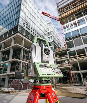
    Leica Geosystems, part of Hexagon, has introduced the Leica AP20 AutoPole — a solution for automated total stations that boosts productivity with tilt compensation, automatic pole-height readings and unique target identification.

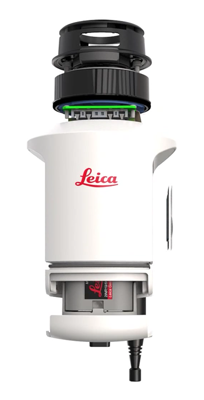
    The AP20 AutoPole combines an intelligent sensor module with the new AP Reflector Pole and operates with Leica Geosystems’ existing automated total stations to create a solution for autonomous workflows.

    It is designed to solve three workflow challenges:

    • holding the pole vertical and stable
    • entering the pole height manually into the field software
    • locking to a foreign target on a site with multiple reflectors.

    The tilt compensation of the AP20 AutoPole increases efficiency when working with total stations. It is no longer necessary to level the pole for measurements and stakeout. Tilt compensation decreases measurement time and increases flexibility and safety on site by enabling the measuring of points in locations that are inaccessible or put the user at risk. By updating the pole height automatically in the field software, the system ensures that the height on record is always correct, which avoids errors, time-consuming postprocessing and returning to the field to remeasure.

    Additionally, the AP20 AutoPole’s target identification ensures the user’s instrument will always lock to the correct target.

    “At Leica Geosystems, we understand that tight time schedules, growing expectations for accurate on-demand data and budget constraints put a lot of pressure on surveyors and construction professionals,” said Hans-Martin Zogg, business director, Total Stations, Leica Geosystems. “The AP20 AutoPole is a game changer because it solves several challenges simultaneously. Its tilt compensation and automatic pole height readings are absolutely unique in the industry and will transform how professionals measure with total stations.“

    “As a surveying company, the only way we can stay competitive and profitable is to acquire spatial data simply, quickly and efficiently,” said Clifton Webb, director of Warner Surveys. “The Leica AP20 helps us stay ahead of the curve by increasing our productivity and flexibility. It allows us to measure points that were impractical or unsafe to measure before.”

  • New Leica Nova MS60 enables surveying with one instrument

    New Leica Nova MS60 enables surveying with one instrument

    The new version of all-in-one MultiStation addresses a wide range of needs. (Phoeo: Leica Geosystems)
    The new version of all-in-one MultiStation addresses a wide range of needs. (Photo: Leica Geosystems)

    The new Nova MS60 MultiStation combines upgraded, faster 3D laser-scanning capabilities, GNSS connectivity and digital imaging with a high-end total station. According to Leica Geosystems, part of Hexagon, the multi-station brings sensor fusion to the “next level.”

    The MS60 features several laser scanning updates, including an fast scanning speed of up to 30,000 points per second, optimized scan area definitions, adapted scan managements, and an improved scanning path for zenith scans.

    It is also equipped with the unique AutoHeight feature, enabling users to save time by automatically measuring the instrument’s height with a simple button press. Measurement professionals can make decisions directly in the field, performing point-cloud analysis such as flatness analysis and as-built checks in the Inspect Surface app of the MS60.

    “Scan data combined with traditionally measured points, whether it’s from the total stations or the GPS receivers, is one of those immediate deliverables that help our clients see what we’re doing. With the scan data of the Leica Nova MS60 MultiStation, we can graphically show — the same day it is collecting — the locations in the field to any person,” said Donald Smith, senior land surveyor and principal at BL Companies. “When you deliver on time and provide customers with a deliverable they can see, you’ve just got yourself a recurring client.”

    The MS60 speeds up workflows by combining technologies in this all-in-one instrument. The MultiStation  total station offers advanced imaging, scanning capabilities and GNSS connectivity. With Leica Captivate field software, all measurement and scanning data can be visualized in 3D for quality and completeness checks.

    MS60 users can seamlessly transfer all data into Leica Infinity software to manage, process, analyze and perform a quality check. The MultiStation helps users deliver projects on time, save money and have high flexibility in the field.

    “The MS60 merges data in a multi-level process — total station measurements are complemented by 3D point clouds, which are automatically registered and coloured by the image information. All data perfectly fits within the same coordinate system, globally referenced by GNSS measurements or by measuring known points,” said Falko Henning, senior product manager at Leica Geosystems.

    “Unlike other measurement devices, the MS60 offers familiar total station capabilities and scanning functionality to fulfil job requirements on site.” Henning said. “The operator can use the red laser pointer to perform reflectorless measurements for direct remedial work on-site or stakeout points and use the field controller even while a scan is performed.”

  • Laser Technology offers TruPoint 300 total station

    Laser Technology offers TruPoint 300 total station

    The TruPoint 300 total station by Laser Technology.
    The TruPoint 300 total station by Laser Technology.

    Laser Technology Inc. (LTI) has released its TruPoint 300 for field data collection and mapping, as well as producing +/–1 millimeter range accuracy. It is a fully integrated laser with vertical and horizontal angle encoders capable of producing 3D, survey-grade measurements.

    The TruPoint 300 is LTI’s first phase-technology product with a laser diode that emits light pulses with a distinct wavelength and pulse repetition frequency that obtains millimeter accuracy.

    The fully integrated MapStar Angle Technology make the Trupoint 300 suitable for GIS, incident mapping, crush analysis, surveying, electric utilities, architecture and construction.

    It will measure the distance between two remote points and has onboard solutions for volume, height, and 2D and 3D area, the company said. Professionals can navigate through measured data, routines, and menus with a full-color touchscreen.

    In addition, the laser features an integrated red-dot visual indicator and crosshair with four-power zoom camera, which makes taking measurements easier, especially indoors, LTI said. The unit will also capture a photo of every shot taken that includes raw measurement values and onboard calculations.

    Both photos and data can be stored in a CAD-friendly format for professional documentation. With Bluetooth and WLAN, professionals can communicate with apps and transfer X-, Y-, Z-point data files with images.

    Several measurement and mapping apps designed by LTI are expected to be released in the coming months. Besides professional-grade lasers for mapping, LTI also provides a line of recreational rangefinders by Bushnell for golfing and hunting.

  • Sokkia releases CX series total station

    Sokkia-cx60-gallery04Sokkia announces the release of the CX-60 total station in the Americas with upgraded data transfer and storage options for the series. Featuring RED-tech reflectorless capabilities, the new CX-60 is designed to provide an entry-level solution with a fast and powerful EDM.

    “The CX-60’s RED-tech technology reflectorless EDM offers a fast distance measurement of 0.9 seconds,” said Ray Kerwin, director of global surveying products. “The instrument also offers a new USB option for quick and easy data transfer, along with 2- and 5-arc second accuracies ideal for land surveying, topography, construction layout, foundations and exterior job sites as well as as-built projects.”

    RED-tech technology allows the total stations to operate reflectorlessly with an EDM of up to 350 m or 4000 m with a prism.

    The CX-60 instruments offer optional Bluetooth functionality, providing connectivity of up to 10 meters (32 ft.) with controllers.

    Additional features include 10,000 points of memory, a battery life of up to 15 hours, dual axis compensation, a waterproof design, and a laser pointer.

  • Topcon's new ES series total station has advanced data-transfer functionality

    Topcon_ES-60_Field-WTopcon Positioning Group announces the release of the latest addition to its ES total station series in the Americas, the ES-60. Featuring advanced reflectorless capabilities and an upgraded data-transfer functionality — the new ES-60 is designed to provide an entry-level total station option with a fast and powerful EDM.

    “The ES-60 is an excellent solution for customers looking for the dependability and accuracy of the ES series in an entry-level package,” said Ray Kerwin, director of global surveying products. “Incorporating all the time-honored expectations of the ES series along with a reflectorless EDM of up to 350 m, and 4000 m with a prism — the instrument also offers a USB option for quick and easy data transfer.”

    The ES-60 offers 2- and 5-arc second accuracies. “It’s ideal for land surveying, topography, construction layout, foundations and exterior job sites as well as as-built projects,” said Kerwin.

    Additional features include 10,000 points of memory, a battery life of up to 15 hours, dual axis compensation, a waterproof design and a laser pointer.

  • Robotic riverbed survey reveals unseen depths

    The Ribble River flowing through Preston in Lancashire, United Kingdom, has hidden depths.

    “The challenge with rivers is that much of the beauty and interest is hidden from view beneath the surface,” said Jack Spees, CEO of the Ribble Rivers Trust. “To reveal this beauty, we undertook a bathymetric survey of a section with particularly interesting features that is adjacent to a heavily used public footpath.”

    The trust is using survey results to reveal these hidden depths on interpretation boards, including digitally augmented reality and video media enabling visitors to explore the underwater world.

    For the survey, a robotically controlled 1.2-meter twin-hull shallow draft vessel powered by a twin-jet system surveyed a hectare of the riverbed. It carried depth-recording sonar and a tracking prism that enabled a Spectra Precision Focus 35 total station to lock onto and robotically follow and record the vesssel’s location.

    Echo soundings were transmitted to a tablet PC ashore via long-range Bluetooth and time stamped, while the boat’s position was continuously recorded by the total station and sent back to a tablet PC, also using long-range Bluetooth and time stamped.

    The tablet PC ran 4Site, a program that formatted and processed the data from the sonar and the total station into a DWG drawing. Each point was positioned in real time, so the vessel operator could ensure complete coverage. A mesh of a 200-meter section of the river with depths to 3.5 meters was combined with aerial lidar data to produce the survey.

  • Dam repair monitored by robotic total station

    The project raised the dam height by 60 centimeters, reinforcing existing abutments and adding two piano key spillways.
    The project raised the dam height by 60 centimeters, reinforcing existing abutments and adding two piano key spillways.

    At the Razisse dam in southwest France, a Spectra Precision Focus 35 robotic total station was used to monitor structural movements during major repairs.

    The Focus 35 total station on the job.
    The Focus 35 total station on the job.

    The Focus 35 monitored to a half-millimeter accuracy movement of the arch dam abutments during a critical six-week period in the project. Raising the height of the dam was expected to cause the abutments to settle, so the Focus 35 was positioned to measure XY movement to ensure they were settling properly and within expectations.

    Measurements were taken at each step, with results communicated in real time to the contractor through an Excel file. The results enabled engineers to make critical decisions on whether to move further into the project. The final movement was less than a tenth of a millimeter, well within the acceptable value.

  • Laser Technology shares new time-saving mapping tools at Esri UC

    Laser Technology shares new time-saving mapping tools at Esri UC

    Laser Technology Inc. (LTI) is offering a close-up look at its new geospatial information systems (GIS) technology at the 2016 Esri User Conference, which is being held June 27 to July 1 in San Diego, California.

    Attendees are invited to stop by booth #2525 to discover how LTI can help professionals stay connected and map smarter by using its lasers and a personal smart device. The company will be handing out vouchers for a complete mapping solution, which could save GIS professionals hundreds of dollars.

    The New TruPoint 300 with MapSmart on Android, by LTI.
    The New TruPoint 300 with MapSmart on Android, by LTI.

    The company’s MapSmart on Android software combines all of the sophisticated technology that is typically required to collect field data and puts it into a straightforward app for smart devices. The software simplifies the mapping process by allowing users to establish an origin quickly and begin mapping in minutes, LTI said.

    With MapSmart now available on Android, users gain an improved workflow that includes wireless data transfer, a larger display and built-in help support. Users also have the ability to integrate location data by utilizing the GPS from a smart device or improve accuracy with an external antenna.

    LTI is redefining the traditional total station with its brand-new TruPoint 300. A lightweight, compact, simple point-and-shoot laser with survey-grade accuracy, the TruPoint 300 costs a fraction of alternative technology. The unit measures the distance between two remote points and has onboard solutions for volume, heights and 2D and 3D areas.

    Users can collect 3D measurements from a single location using a personal smart device and capture a photo of every shot taken. With the ability to collect on-site, extremely precise data in half the time, the modern total station is a go-to tool for collecting measurements quickly, easily and safely, LTI said.

    “Achieving survey-grade accuracy with a compact and affordable unit is very exciting,” says Derrick Reish, senior product manager for Laser Technology’s Professional Measurement division. “Having the TruPoint 300 and our flagship TruPulse laser products communicate with MapSmart on Android allows us to offer a complete solution for field measurement and mapping.”

    Imagine if you didn’t have to occupy the location you needed to map. LTI has made this possible with LaserGIS for Esri’s ArcPad data-collection software. This software allows users to fully maximize field work productivity. Working seamlessly with the current ArcPad platform, LaserGIS improves the data-collection process by making laser integration faster and easier. Users can now cover more ground in less time and measure the slope distance, inclination, azimuth and position remote features with one, simple shot.

    Laser Technology Inc. is a Colorado-based designer and manufacturer of reflectorless laser measurement devices for GIS, forestry, natural resource management, general construction, utilities, mining and telecommunication applications.

  • Topcon offers ES-50, an entry-level total station plus EDM

    The Topcon ES-50 total station.
    The Topcon ES-50 total station.

    Topcon Positioning Group has released the latest addition to its ES total station series, the ES-50. Featuring advanced reflectorless capabilities, the new ES-50 is designed to provide an entry-level total station option with a fast and powerful electronic distance meter (EDM).

    “With the functionality of many high-end robotic total stations, our ES series is known to be full-featured and ready to tackle modern job sites,” said Ray Kerwin, director of global surveying products. “The ES-50 incorporates all those time-honored expectations, along with a reflectorless EDM of up to 350 meters, and 4,000 meters with the use of a prism.”

    The ES-50 offers 2- and 5-arc second accuracies for distance measurements in projects such as land surveying, topography and as-built, construction and layout, or foundation and exterior job sites.

    Additional features include a battery life of up to 15 hours, dual-axis compensation, a waterproof design and a laser pointer.

  • Topcon DS-200i connects with Autodesk iPad layout app

    ts_ds_cutout_2Topcon Positioning Group’s DS-200i direct-aiming motorized imaging station is now compatible with the new Autodesk BIM 360 Layout app for the Apple iPad.

    The DS-200i is the second total station solution that Autodesk and Topcon have collaborated on for contractors, following the Topcon LN-100 Layout Navigator.

    The DS-200i has an electronic distance measurement (EDM) range of up to 1,000 meters (3,280 feet) without the need of a prism, and 5,000 meters (26,240 feet) with one. The built-in wireless WLAN connects the iPad with the BIM (building information modeling) 360 Layout app.

    The collaboration provides contractors the ability to connect a coordinated model to the field layout process, helping to increase job-site productivity while improving the accuracy of staked or installed building components, according to a Topcon news release.

    Additionally, the DS-200i offers an excellent reflectorless solution for quality assurance and quality control workflows — verifying items in the field are installed correctly as compared to models.

    The DS-200i features real-time video imaging with a 5 MP camera. The controller’s touchscreen video and arrow keys are designed to let remote operators view what is being measured, Topcon said, similar to looking through the telescope.

    The Autodesk BIM 360 Layout app is available through the Apple App Store.

  • Nikon-Trimble Introduces Updated Nikon Total Stations

    Nikon-Trimble Co., Ltd. introduced today updated mechanical total stations to expand its portfolio of solutions for mainstream surveying and construction applications.

    The announcement was made at INTERGEO 2015, the world’s largest conference on geodesy, geoinformatics and land management.

    The updated products include:

    Nikon NPL-322+ Series – an updated series of reflectorless 2” and 5” total stations providing powerful solutions and an excellent choice for value in terms of price and performance. The NPL-322+ Series feature a distance measurement accuracy of up to ±(2 + 2 ppm x D) mm and provide a long-distance reflectorless measurement range of 400 meters (1,312 feet.). The Nikon NPL-322+ Series also include a coaxial laser pointer, Bluetooth connection to external data collectors, onboard storage for 25,000 points and dual-axis compensation for significantly faster measurement times.

    Nikon DTM-322+ Series – an enhanced series of economic, prism-based 2” and 5” total stations offering full featured functionality in an entry-level package. The DTM-322+ Series offer a distance measurement accuracy of up to ±(3 + 2 ppm x D) mm and a measurement range of 2,300 meters (7,540 feet.) to a prism. In addition, the Nikon DTM-322+ Series include a Bluetooth connection to external data collectors, onboard storage for 25,000 points, dual-axis compensation and new, long-lasting Li-Ion batteries.

    “The Nikon optical portfolio continues to evolve to meet the ever changing needs of our customers who truly appreciate the reliability and dependability represented by the Nikon name,” said Olivier Casabianca, Spectra Precision Business Area Director. “Our customers enjoy the benefits of a mature, robust portfolio of survey and construction products from a single supplier they can trust.”

  • Trimble Expands Geospatial Portfolio to Increase Productivity


    Trimble-S9-Total-Station-Application-W

    Trimble has expanded its portfolio of geospatial solutions for surveyors, engineers and mapping professionals. Highlights include new total stations, a new GNSS receiver and new field and office software features. The solutions save time, reduce costs, streamline workflows and produce high-quality geospatial deliverables across a wide range of industries, Trimble said.

    “Trimble’s portfolio expansion will enable our customers to work in a more efficient, seamless and collaborative manner,” said Chris Gibson, vice president of Trimble. “Trimble’s solutions are best known for quality, dependability and performance. Our vision is to equip customers with the most innovative tools, which includes a focus on offering new software applications that streamline and elevate the value of geospatial data to guide smart decision-making and transform the way organizations work.”

    The expanded portfolio of productivity solutions include:

    Total Station Solutions

    Trimble-totalstations-W

    A range of new and enhanced robotic total stations — the Trimble S5, S7 and S9 — improve project efficiencies, productivity and deliverables. Times saving enhancements include improved Trimble VISION technology, SureScan technology included in the S7 and optional in the S9 total station, and the DR Plus electronic distance measurement technology as a standard feature.

    Theft and loss risks are also minimized now with Locate2Protect technology embedded in each instrument, allowing users to remotely track the location of their equipment in real-time using Trimble InSphere Equipment Manager.

    In the office, Trimble Business Center software can be used to create high-dynamic-range (HDR) images using data captured with total stations. A new total station data editor enables fieldwork to be rapidly reviewed and allows surveyors to create deliverables with confidence, Trimble said.

    Scanning Solutions

    Trimble continues to blend powerful 3D laser scanning and imaging hardware with workflow-based software to drive new efficiencies for survey applications and construction planning and design.

    The Trimble TX8 3D laser scanner now offers greater accuracy (down to 1 mm) and streamlined onboard operation when measuring to longer ranges, decreasing the field time required for capturing reliable high-accuracy data.

    Enhanced tools in Trimble RealWorks software version 9.1 further reduce the time to produce high-quality deliverables from Trimble TX8 data. The new version of Trimble RealWorks software includes improved workflows for creating floor settlement plans and 3D pipeline models as well as complete storage tank inspection and reporting capabilities.

    GNSS Solutions

    The new Trimble R8s Integrated GNSS receiver and updated version of Trimble Access field software combine to offer configurable and scalable settings. Surveyors have the flexibility across their workflows by being able to tailor the Trimble R8s receiver with the updated field software for their specific application. The ability to customize provides flexibility for future business requirements and allows customers to maximize efficiencies across their workflows.

    cameraSightImage_S6-W

    Imaging Solutions

    Trimble enhancements to Trimble VISION workflows increase the value of highly accurate image data. Survey, engineering and civil infrastructure professionals can now generate dense point cloud deliverables in Trimble Business Center from images captured using the Trimble V10 Imaging Rover. Users can also quickly generate 2D CAD and 3D real-world models from images captured with Trimble total stations using the streamlined workflows created within Trimble Business Center and SketchUp software.

    Availability

    Trimble Access field software, Trimble Business Center version 3.50 office software, the Trimble R8s GNSS receiver, Trimble S5, S7 and S9 Total Stations and TX8 3D Scanner are available now through Trimble’s Geospatial Distribution Channel.