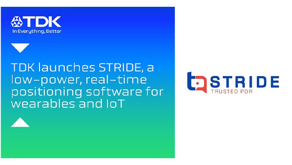
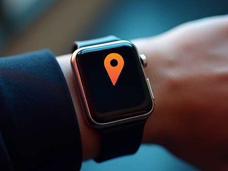
TDK Corporation has announced Trusted Positioning STRIDE, an embedded pedestrian dead reckoning (PDR) software solution engineered specifically for wearables such as smart watches, head-mounted devices, glasses and compact sensors.
As OEMs push for more intelligent, context-aware wearable experiences, STRIDE provides reliable positioning without the power and hardware demands traditionally required for GNSS-based tracking.
Wearables today face a critical challenge: adding high-quality positioning typically requires bulky antennas, high-drain GNSS or costly custom hardware — barriers that limit form factor, battery life, and user experience.
STRIDE overcomes these constraints with a low-power, sensor-agnostic software engine that fuses inertial data with GNSS and opportunistic wireless signals, delivering continuous location tracking indoors, outdoors and everywhere in between.
STRIDE runs as embedded software, giving OEMs freedom to deploy positioning without redesigning hardware or relying on cloud connectivity. STRIDE processes sensor data in real time, ensures low latency, and can be configured for on-device, companion-device, or cloud-assisted architectures. This flexibility helps manufacturers balance performance, power, and form-factor constraints based on their device strategy.
For integration questions or technical documentation, contact TDK.
TDK Corporation has announced Trusted Positioning STRIDE, an embedded pedestrian dead-reckoning (PDR) software solution engineered specifically for wearables — smart watches, head-mounted devices, glasses and compact sensors. STRIDE provides reliable positioning without the power and hardware demands traditionally required for GNSS-based tracking.
STRIDE’s low-power, sensor-agnostic software engine fuses inertial data with GNSS and opportunistic wireless signals, delivering continuous location tracking both indoors and outdoors.
STRIDE runs as embedded software, giving OEMs freedom to deploy positioning without redesigning hardware or relying on cloud connectivity, according to the company. STRIDE processes sensor data in real time, ensures low latency, and can be configured for on-device, companion-device, or cloud-assisted architectures. This flexibility helps manufacturers balance performance, power and form-factor constraints based on their device strategies.
Main features and benefits
Low-power on-device mode: Enables continuous PDR in platforms constrained by power, memory or thermal limits.
Geofencing mode: Allows location-based alerts and boundaries for children’s wearables, personnel safety, or activity zones.
Tethering of sensors: Seamlessly uses GNSS and sensors from a companion phone, reducing hardware demand on the wearable.
Off-device processing: Supports computation on a smartphone or in the cloud for advanced analytics or battery saving.
GNSS duty-cycling: Dramatically extends battery life by activating GNSS only when necessary.
Flexible mounting support: Works across watches, smart glasses, helmets, chest-mounted devices and more.
Embedded and real-time: Runs directly on the device with low latency — no dedicated infrastructure, no specialized hardware
Hardware-independent and sensor-agnostic: Integrates easily with a broad range of IMUs and GNSS receivers.
STRIDE is available immediately for trial evaluation, OEM integration, or companion-device implementations.
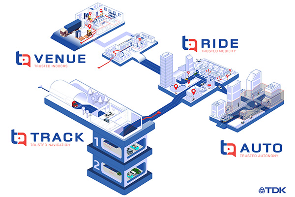
TDK Corp. has announced that Trusted Positioning Inc. (TPI), a TDK Group Company focused on creating and selling positioning software, has joined the New Business Promotion Center of TDK Corporation as an independent business unit.
With the expanding positioning and location tracking market, this move signals TDK’s commitment to developing TPI as an independent software solutions business, according to a TDK press release.
TPI has been developing integrated positioning solutions for decades, with software deployments in more than 50 million systems worldwide. The company’s innovation team is comprised of experts in inertial navigation, dynamic motion mechanics, geomagnetic positioning, GNSS, Bluetooth low energy, Wi-Fi and other wireless positioning techniques.
TPI’s inertial navigation solutions provide highly accurate positioning for the autonomous vehicle, automotive infotainment/telematics, robotics, two wheeled micro-mobility and indoor positioning markets.
VENUE (previously Coursa Venue) is TPI’s flagship indoor positioning solution based on inertial, geomagnetic and other wireless technology. The indoor positioning market is exploding with the now-ubiquitous GPS everywhere, except indoors. TPI’s indoor positioning requires minimal infrastructure investment, which reduces costs, and is well suited to scale for large venues.
RIDE is TPI’s two wheeled micro-mobility solution (previously called MML) for the burgeoning rental bike and electric scooter industry. This software solution enables the return and location identification of vehicles in urban areas where GPS is less accurate, and facilitates correct orientation of parked bikes to ensure city standards are met.
TPI’s TRACK product (previously named IPL), fuses GNSS and an IMU to provide accurate dead reckoning for automobile infotainment and telematics systems during GNSS outages in tunnels, underground parking and other sheltered areas.
TPI’s AUTO solution (previously known as Coursa Drive) improves reliability in autonomous vehicles and robots utilizing onboard radar and inertial sensors. AUTO provides all weather decimeter level positioning accuracy in urban areas with limited GPS signal availability.
With the introduction of TPI’s new structure and product names, today TPI also launches a new dedicated website: www.trustedpositioning.com.
“Relaunching our business and brand while leveraging a SaaS business model, partnering with major companies around the world and keeping them competitive, marks a strategic move for TPI”, says Chris Goodall, managing director and founder of TPI.
To prevent the further spread of COVID-19, the world is shifting to a “new normal” in which social distancing is practiced and contact between people is avoided. Due to early evidence suggesting the spread of COVID-19 is much more aggressive indoors than outdoors, many companies have begun efforts to monitor workers’ movements and trace contacts to keep offices and factories from becoming new epicenters of infection.
The Need to Monitor
Keeping a safe distance from others and avoiding contact is essential to prevent getting infected with COVID-19. However, there are many situations where avoiding contact with others at indoor locations such as offices and factories is difficult. Hence, there is a growing need for technologies that monitor contact between workers and their movement histories in real time.
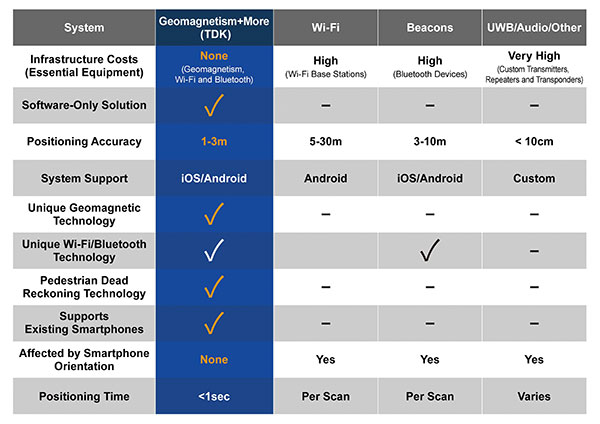
Indoor location information can be obtained using various wireless communication technologies including Wi-Fi, Bluetooth and ultra-wideband (UWB). For example, Bluetooth beacons have been deployed at commercial facilities to enable services that provide location-relevant information to customers with smartphones. The positioning accuracy of Bluetooth, however, is only around 3 to 10 meters and is dependent on infrastructure installation.
To be useful for contact tracing of infectious diseases, the number of beacons must be increased to achieve an adequate level of accuracy. UWB technology features high positioning accuracy, but deployment in a wide area would require installation of a large number of radio transceivers and repeaters, putting it at a cost disadvantage.
Solution Based on Geomagnetism
Given this background, a solution using geomagnetism is attracting attention. TDK has developed VENUE, which displays the real-time locations of people by utilizing geomagnetic sensors found in today’s smartphones. Each indoor location has a geomagnetic signature that can be used to ascertain the position of the phone.
There are several approaches to indoor positioning, but geomagnetism, tightly coupled with inertial navigation, optimally balances accuracy, reliability and cost of deployment and maintenance.
“The beauty of geomagnetic positioning is that it works in all large venues whose structures interfere with Earth’s magnetic field, making this an infrastructure-free approach to indoor positioning that is accurate to better than 2 meters,” said Chris Goodall, founder and managing director of Trusted Positioning Inc., a TDK Group Company based in Calgary, Alberta, Canada.
VENUE provides a position display with even higher accuracy by combining geomagnetic information with information from accelerometers and gyroscopic sensors inside smartphones.
VENUE requires only the creation of a geomagnetic map that combines an indoor layout map with the geomagnetic data of that particular location acquired through a survey, with no need to install new devices and terminals. This leads to low installation cost. The accuracy of positioning using geomagnetism is better than two meters (6 feet) — sufficient for tracing contact with infected persons. In addition, VENUE provides a position display with even higher accuracy by combining geomagnetic information with information from accelerometers and gyroscopic sensors inside smartphones.
“People may hold their smartphones while walking or put them in their pockets or bags,” Goodall said. “Since the orientation to the user changes constantly, the movements and pedestrian use cases need to be corrected using inertial sensors. Solving these issues was the greatest challenge for practical applications such as tracking, and took our team many years to create, perfect and protect.”
Comparison of indoor location information technologies. (Chart: Trusted Positioning)
Real-World Trial Under Way
Beginning in August, a contact tracing trial among workers is being conducted at TDK’s headquarters in Nihonbashi, Tokyo, using VENUE. Employees carry smartphones with a special app installed, and their positions and movement histories on the floor are combined with anonymous identification information. If an employee is found to be infected, the data will be analyzed to identify people who had contact with that employee within the preceding two weeks, and measures such as stay-at-home instruction will be taken.
This solution not only can identify those who were in close contact with the infected person as primary contacts, but also trace those who stayed in areas where the infected person had been shortly before as potential “area contacts.” Analysis that combines location and elapsed time enables more effective contact tracing by improving primary contact tracing indoors and enabling area-based contact tracing over time.
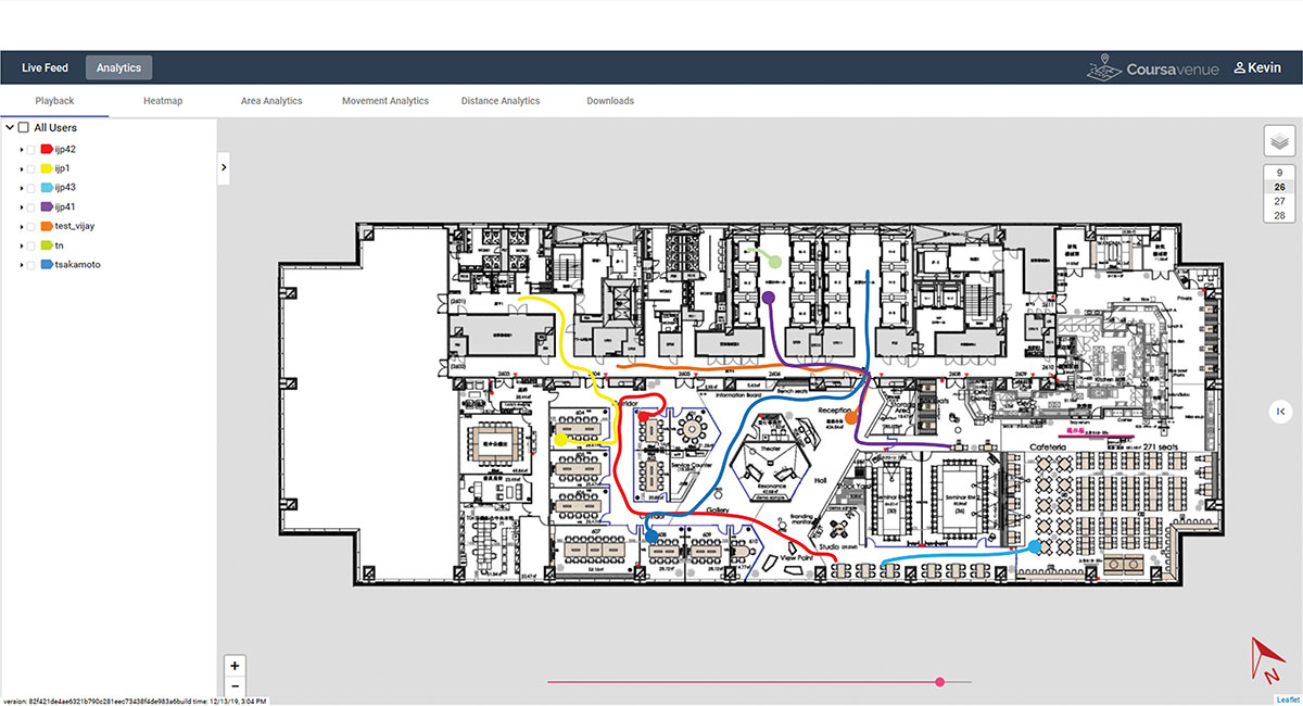
Ongoing Trial at TDK Headquarters: VENUE displays an individual worker’s tracking data on the dashboard. (Conceptual illustration: Trusted Positioning)
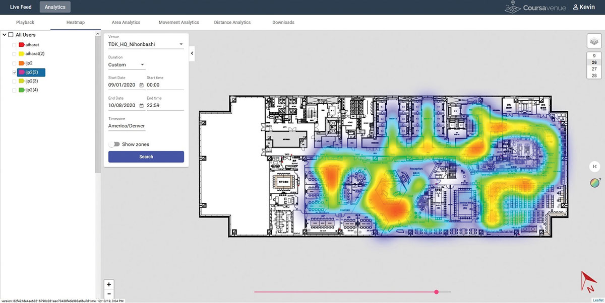
Ongoing Trial at TDK Headquarters: A worker’s durations of stay and positions can be visualized in the form of a heat map. (Conceptual illustration: Trusted Positioning)
New Possibilities Opened
Because VENUE can display the positions and histories of people and objects using not only workers’ smartphones but special tags containing geomagnetic and inertial sensors (under development), it can be deployed for a wide range of applications beyond contact-tracing of infectious diseases. Possible uses include monitoring the flow of employees to improve operational efficiency or tracking positions of equipment to manage their operational statuses. TDK is working with a number of companies on solutions to improve business efficiencies using location information.
Many offices have introduced open seating, so maintaining a “real-time seating chart” using VENUE is a real advantage so staff can more easily find one another in large office settings, encouraging more collaboration between staff and departments.
Companies have been using Bluetooth low-energy (BLE) beacons to manage the movement of workers, materials and equipment indoors in warehouses, factories and construction sites. VENUE can reduce the installation and maintenance costs of such systems, especially in large-scale facilities.
VENUE is also useful for other contact-tracing applications that do not focus on viral transmission, such as human-to-machine, human-to-vehicle and human-to-robot contacts. The future work environment will undoubtedly change with more automation, and the interaction of humans and machines poses safety concerns. VENUE’s designers hope it can improve safety in many types of contact-tracing applications.
Similar to the expansion of GPS for outdoor positioning applications, indoor positioning technologies will likely grow in our everyday lives. VENUE is one indoor location information solution that enables highly accurate location information to be obtained while keeping infrastructure costs down.
InvenSense Inc. is making available its InvenSense Positioning Library (IPL) software, designed to provide sensor-assisted positioning in places where GNSS alone cannot provide desired accuracy. Invensense is a provider of intelligent sensor system on chip for motion and sound in consumer electronic devices.
InvenSense made the announcement at Mobile World Congress, taking place in Barcelona, Spain March 2-5.
The IPL incorporates advancements in sensor-assisted positioning algorithms that allow use of inertial sensors to improve GNSS positioning in urban areas where satellite signals are either blocked or distorted by multipath, enabling continuous location availability while driving in underground parking lots, tunnels, or walking in urban canyons. The IPL enables continuous and accurate position, velocity and orientation in challenging operating environments.
These sensor-assisted positioning algorithms have been designed to operate under normal pedestrian and driving use without restrictions on the device orientation. Supported pedestrian use includes handheld, hand swinging, in pocket, call mode and belt holster. The algorithms also allow any use within the vehicle, such as in cradle, cup holder or simply left on a seat. The software was designed in a way to maximize accuracy and minimize constraints on the user.
The IPL is designed to operate with an IMU and GNSS receiver as minimum hardware. Integration with a magnetometer, barometer, and vehicle speed sensor is also available, which provides additional heading integrity as well as height and velocity accuracy for sensor-assisted positioning.
IPL is designed for smartphones using Android, iOS, Windows and general Linux operating systems and has already started shipping commercially. The underlying navigation technology comes from years of development at Trusted Positioning Inc., which was acquired by InvenSense this past summer.
“With more consumers using their smartphones for turn-by-turn navigation on foot or in vehicle, one of the most frustrating user experience issues is losing your GPS (GNSS) signal in an unfamiliar location or being re-routed erroneously due to multipath errors,” said Ali Foughi, vice president of Marketing and Business Development at InvenSense. “With IPL technology, high-accuracy location guidance is always available and provides smartphone OEMs with a differentiated user experience and consumers with a more reliable navigation solution.”
The InvenSense Positioning Library is available immediately.
InvenSense is exhibiting in booth #D61 in Hall 7 at Mobile World Congress.
A number of factors are holding the proximity marketing/indoor positioning markets back: standardization issues, consumer acceptance/privacy, retailer awareness and the technology itself. However, as one location executive put it, it may be the one way that retailers with brick and mortar stores can compete with Amazon and other online giants.
Indoor location and proximity marketing may be the way large and small brick and mortar stores can compete with online retailers in the future, said panelists at the New York Place conference, held July 22. But all of this indoor location market talk doesn’t mean much if consumers don’t find a need for it.
“I am in an aisle at a grocery store and you sent me a coupon for cat food, and I don’t have a cat, I am not going to be interested. The retailer gets to own the data by providing a great experience to the consumer, not the spontaneous ‘you are in a store — here’s some information,’” said John Dempsey, Datalogix head of mobile and video.
While having a broad picture of a consumer’s “mobile moment” is important, there is something to be said about bombarding a consumer with too many location-based applications, said Doug Kilponen, Wanderful Media chief operating officer. “There are a limited number of apps consumers are willing to have, but not 200 different ones. It’s one thing to have an app for say, Target, but trying to find out what is broadly available during shopping makes shopping too much work,” he said. “Trying to find out what’s available becomes too much work as there are too many options [for the consumer].”
From a retailer’s perspective, they want consumer’s data, and will share it with partners, but they also want control, said Catherine Lindner, Shelfbucks chief marketing and merchant officer, who was an executive at Walgreens. “If you think about your own shopping behavior, there is only a few places you actually go to and spend money — a grocer, drug store. That retailer wants your data, and it makes sense,” she said. “How do we spend the money to grow the business? The idea that there is one bucket of money to transfer is not going to happen.”
One company says that consumers don’t want to be “advertazed” by retailers. “Their job is to show you Calvin Klein, but sometimes there is not enough information or context. They hijack moments, rather than create them,” said Scott Townsend, Urban Airstrip director of agency programs.
Still, retailers are increasingly using indoor location as part of their mobile strategies. Jewelry chain Alex and Ani has three beacons in their Boston and New York stores, said Ryan Bonifacino, Alex and Ani vice president, digital strategy. “We really want to prove that this [indoor location] can really work. We really want to get in front of people who wouldn’t have discovered us,” he said.
Indoor Location Standardization? What Standardization?
Like any new technology and market, industry standardization will have growing pains, and a lot of the problem may be with the retailers, said panel members. “There are issues with standardization. If Walmart puts a [indoor positioning] in to its store — they don’t care if it works anywhere else,” said Don Dodge, Google developer advocate.
Indoor location is the classic chicken-before-the-egg situation, said Chris Goodall, Trusted Positioning founder and CEO. “There currently are no standards for indoor [positioning], maybe we need it. Databases are not standardized,” he said.
A lot of the reason that standardization has not be resolved is that no big application, the old killer app, has appeared. “Indoor is something that has not emerged yet, it’s a long tail story,” said Dan Ryan, ByteLight co-founder and CEO. “Every location company is trying to build a network — and naturally attract developers.”
Making Proximity and Indoor Location Relevant to Retailers
Some retail chains like Walgreens have used indoor positioning technology for years and are considered some of the major early adopters. However, making consumer-purchasing behavior data relevant to retailers is the only way for indoor marketing to take off.
The concept of geofencing each store has been tested in several locations. One company envisions an image of a celebrity greeting consumers in a store with an offer. “Walgreens focused on not invading people’s privacy. But they basically asked users, what’s important to them when they walk into a store,” said aisle411 founder and CEO Nathan Pettyjohn. “[Bluetooth Low Energy] beacons can do this very elegantly. When a consumer walks through a store, perhaps they see a celebrity popping out to greet them.”
In many successful mobile marketing campaigns, all have a common theme — proximity components always enhance sales, said James Smith, Verve chief revenue officer. “Every one of our studies says it drives sales. Sometimes we hear that geofences don’t work — my answer to that is they are in the wrong places,” he said. “A person can go into a place 15 days later and a beacon locks on them — the retailer is happy because it works. Consumers are more empowered because they have a research device in their hand to go where they want to go.”
Case Study: Walkbase
A Finland-based company is delivering market research to retailers that examines consumers’ in-store shopping behavior and loyalty patterns. Walkbase, which signed a deal with Helsinki airport operator Finavia, started in 2007 when it spun off from an indoor location company.
“It’s a retail tool that analyzes indoor performance of marketing campaigns and [sales] conversion. It measures when consumers come into a store — do they bounce out or are they engaged?” said Juha Mattsson, Walkbase vice president, sales and marketing. “A retailer can launch a campaign that is affected by a consumer’s indoor journey. Whether that is through coupons, or not, as some retailers don’t want that.”
Mattsson says that the company is operating primarily in Europe — and is waiting for what indoor technologies will win. “It is just a matter of time before the market takes off. Retailers are very interested in these types of consumer spending analytics,” he said. “We will be launching a U.S. white paper on in-store optimization as it’s all about education. We also are rolling out a version 2.0 of our product in the third quarter.”
In other LBS news:
According to published reports, Michael Halbherr, CEO of Nokia’s HERE mapping unit, will be stepping down. Halbherr, who is based in Berlin, steps down after eight years at the company. As recently as 2012, HERE, then called Navteq, had been losing money but had stabilized recently. Cliff Fox, HERE senior vice president, will be acting CEO until a replacement is found.
I will be covering CTIA’s Super Mobility Week in Las Vegas, Sept. 8-11. To arrange an interview with me for Wireless LBS Insider, or to submit press releases, contact me at [email protected].
InvenSense, Inc., a provider of intelligent sensor solutions, has signed a definitive agreement to acquire Trusted Positioning, Inc. (TPI), a privately held indoor/outdoor tracking company with the vision to provide “Positioning Everywhere.” InvenSense is also acquiring context analysis software company Movea.
TPI’s location tracking technology improves accuracy both indoors and outside by augmenting GNSS and Wi-Fi based location infrastructure. Using inertial sensors such as accelerometers, gyroscopes, magnetometers, and pressure sensors in mobile and wearable devices, TPI’s software platform provides continuous and accurate positioning and also solves the difficult problem of alignment between the user and the mobile device. The TPI platform provides complete inertial navigation software solutions for a variety of industries including smartphones, tablets, wearables, in-vehicle navigation, personnel tracking, and machine guidance and control.
“InvenSense shares our passion for ‘positioning everywhere,’ and they have been a strong supporter of the Trusted Positioning team, technology and vision,” said Chris Goodall, Trusted Positioning’s chief executive officer. “We are pleased to be joining the InvenSense family with the goal of making indoor/outdoor positioning ubiquitous. Together with InvenSense we will now have the required resources and investment to mainstream this technology.”
InvenSense has also signed a definitive agreement to acquire Movea, a privately held company that provides software for ultra-low power location, activity tracking, and context sensing. Movea’s products, technology, and IP cover a broad range of signal-processing and data-fusion technology applied to consumer mobile (smartphones and tablets), TV interaction, and wearable sports and fitness applications.
Movea is dedicated to context analysis using both motion and audio sensors to determine, for example, a person’s state/activity, their energy expenditure, their location, and an athlete’s speed and cadence. Movea’s algorithm and software framework expertise is expected to further scale InvenSense’s leadership in motion software and accelerate InvenSense’s “AlwaysOn” low-power solutions for mobile and the Internet of Things.
“With the addition of Movea and TPI, InvenSense achieves a significant milestone as it transitions to a leading provider of intelligent sensor System on Chips (SoC) for the fast growing mobile market. ‘AlwaysOn’ location and activity tracking are essential to enabling contextually aware products and services,” said Behrooz Abdi, president and chief executive officer, InvenSense. “The tight integration of our low-power, high performance, motion and sound sensors, along with TPI’s advanced location tracking software and Movea’s data fusion algorithms, will position us to deliver on this ‘AlwaysOn’ promise.”
In connection with the acquisition of both companies, InvenSense expects to pay approximately $81 million, net of cash assumed, to acquire all of the outstanding shares of capital stock and other equity rights of Movea and Trusted Positioning, Inc. The purchase price will be paid with $6M of InvenSense common stock and the remainder in cash, except that portion attributable to unvested employee stock options will be paid in stock options exercisable for shares of InvenSense’s common stock.
A portion of the cash consideration payable to the stockholders will be placed into escrow pursuant to the terms of the acquisition agreement. The estimated financial impact of the acquisitions upon the future operating results of InvenSense, which is not expected to be significant, will be discussed during the next regularly scheduled quarterly investors analyst conference call planned for July 29.
The boards of directors of InvenSense and the two companies have approved the mergers. The transactions are expected to close by the end of InvenSense’s second quarter, September 30, and remains subject to the satisfaction of regulatory requirements and other customary closing conditions.
At the turn of the century, the premise was that GPS was revolutionary, would work everywhere we needed it, and everything else was old hat. Turns out that we need something that works indoors and in critical outdoor applications without a clear view of the sky, like downtown cores, dense forests, and in-and-out of coverage places like mountain valleys. A Canadian team out of Calgary obtained a couple of key patents and founded a business around navigating with sensors when GPS/GNSS was obscured or just plain not available. Just coincidentally, around the same time, cell-phone and tablet manufacturers were adding these same sensors to their devices so users could readily re-orient screens and play motion video games.
I spend winters in Florida, and in the summer I’m in Calgary, Alberta — of late, “summer” can be a somewhat misunderstood term when talking about weather in that part of Canada; many may recall the devastating floods in that region this year, but nevertheless it’s my home for several months of the year. This year while I was there, I visited Calgary-based Trusted Positioning, Inc., in its offices across from the University of Calgary (UofC), and again at the ION convention in Nashville. I recently had the opportunity to catch up with the staff again and to get a progress update on their unique business and positioning technology.
To bring us all up to scratch on who or what is Trusted Positioning, Inc., (TPI) and where they came from, here’s a brief refresher.
TPI has been around since 2009 as a spin-off of geomatics engineering research by its four founders at UofC. Naser El-Sheimy was the prof, and Chris Goodall (now TPI’s CEO) and Zainab Syed were his grad students when MEMS started to become of interest to the group — their focus had previously been largely on tactical grade IMUs and integration with GPS. They put together a report in 2000 on the opportunity that MEMS offered for navigation, and this started them thinking of potential commercial prospects.
So the following year, two proposals were submitted and ultimately accepted by Canadian government support agencies. This eventually provided start-up funding for what was to become TPI. Chris and Zainab earned their Ph.D.s in 2008, and Jacques Gregory joined them from Queens University in 2009. The first two or three years were tough, and El-Sheimy advises if you are not prepared to give up your existing lifestyle throughout the launch period — family, fun, vacations, finances, even sleep — don’t take on starting such a business. In this case, things ultimately worked out for the founders, and TPI is now launched and doing well.
In those days, the premise was that GPS was still revolutionary, would work everywhere we needed it, and everything else was old hat. Turns out as time passed we wanted something that worked indoors and also in a number of critical outdoor applications where there wasn’t exactly a clear view of the sky — like downtown cores, in dense forests, or in-and-out of coverage places like mountain valleys.
The pre-TPI research at UofC led to a couple of key patents that went with the team into the new business, and as the business grew, new in-house patents began to be developed — all around navigating with sensors when GPS/GNSS was obscured or just plain not around. Coincidentally, cell-phone and tablet manufacturers were then adding MEMS inertial components so users could readily reorient screens and play motion video games, so TPI began to use these sensors for inertial aiding or even inertial navigation for handheld personal navigation.
Nowadays, TPI has around 20 employees, has developed more than 20 distinct patents with more in the works, and has been licensing software since 2011. The initial Canadian government (NSERC and NRC) support funding has been replaced by equity investment of more than $2 million and key strategic partners who have signed on as investors. Plus, a strong technology/business-oriented board has been put together. Well-known industry players John Ladd (ex-CEO of NovAtel) and Werner Gartner (ex-CFO of NovAtel) have joined TPI’s board, and several past NovAtel executive team members have also invested a significant portion of the equity raised to date. It has to be a good sign when industry leaders like those invest and believe in the direction TPI is taking.
Don Dodge.
The latest advisor to lend support is Google’s “Developer Advocate” Don Dodge — a guy who specializes in picking out key technology companies at the right time, invests in them personally, and then helps guide them to greatness.
Before becoming a “Developer Advocate” at Google, Dodge was the director of Business Development for Microsoft’s Emerging Business Team. He was also part of the leadership for technology start-ups Forte Software, AltaVista, Napster, Bowstreet, and Groove Networks. “Indoor location and positioning technology is the next big thing,” says Don Dodge, “and sensors are the foundation of this technology. I’m excited to work with Trusted Positioning, the market leader in using sensors for indoor location.”
TPI doesn’t only use MEMS inertial sensors (accelerometers and gyroscopes) in phones; it also uses magnetometers, barometers, and available Wi-Fi networks and their associated location databases, GNSS, vehicle speed sensors, user updates, and camera inputs.
As its brochure says, “Sensor solution is always on when moving and provides a consistent accuracy output to seamlessly integrate with all available updates.”
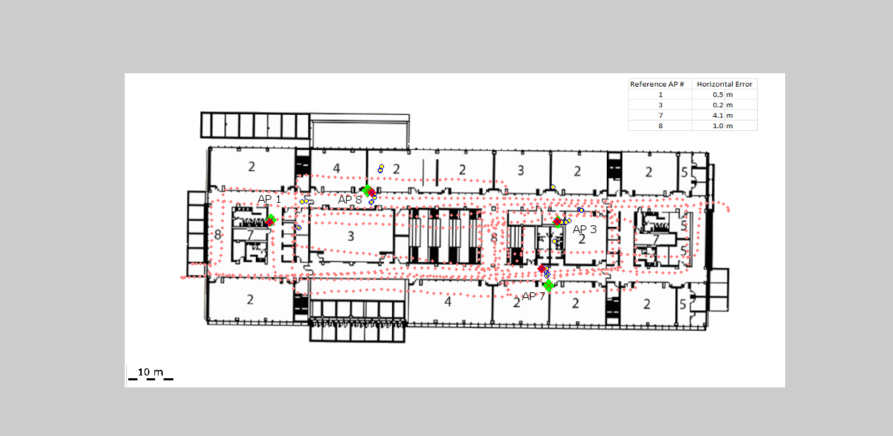
The problem with Wi-Fi is that the databases don’t stay totally reliable — so TPI solves this problem by also collecting data using other integrated sensors for positioning, which can then be used to update the very same Wi-Fi location data. This is one of the market areas that TPI believes it can access, since Wi-Fi positioning is becoming a more common navigation source. TPI would say Wi-Fi should be considered as only part of the solution, as it needs help from other sensors to work well.
Estimated Wi-Fi access point locations using sensors.
The Trusted Portable Navigator (T-PN) navigates while people walk or drive and use their cell phones in any orientation, anywhere and everywhere — including malls, airports or subways. T-PN combines the use of existing smartphone motion sensors with wireless updates (such as Wi-Fi and GNSS) for a complete solution with no extra hardware or infrastructure.
Over the last three years, TPI has developed an entire library of typical profiles for how people move and carry their cell phones. Algorithms detect particular movement profiles and then use appropriate filter adjustments to maintain or improve accuracy when in locations such as urban centers.
T-PN software has been released by TPI this year for integration in any mobile phone, tablet, or PC operating systems, with a view to capturing expanding mobile market applications, such as mobile advertising, indoor E-911, augmented reality, and fitness/recreation. Pedestrian navigation, navigation in parking garages, monitoring the location of devices in store displays, and assisting store visitors to find what they are looking for — all these potential applications are opportunities for TPI solutions. Therefore, TPI has so far chosen to market to mobile OEMs, MEMS and semiconductor manufacturers who can embed TPI software solutions in phones or in MEMS devices or components that go into these phones.
New technology areas that TPI is working on include wearables and using cameras as navigation sensors.
Now that a number of devices such as phones, watches, tablets, and (Google-like) glasses come with Bluetooth tethering, their movement can all be integrated to improve the navigation solution for people on the move.
TPI estimates that its sensor drift is approximately 4-8 percent of distance traveled when operating without any wireless updates. Chris Goodall calculates that adding multiple devices could improve overall accuracy of the navigation solution by up to threefold.
And how the heck do you use a camera as a navigation sensor without a massive visual database? Simple — just focus on a stationary object and calculate the turn rate of the camera/user. Not so easy, really, as continuously detecting stationary objects as the user moves sounds quite complex. How do you differentiate between objects moving and the camera/user moving? “Feature flow” over multiple images is apparently the answer in deriving velocity and turning rate. We’ll have to see when and how TPI will solve this problem and field a solution — but I suspect it may be very soon as TPI is apparently providing sneak-peak, hands-on demos at a number of upcoming trade shows this year.
Lots of companies are working on solutions to the indoor navigation problem, but as Goodall indicated, after first discussing things with TPI and then going off to try to do it themselves, people tend to come back to TPI. Its not as easy as it sounds, and it takes time and lots of trial and error to get anything that works, then making something that works reliably under all conditions is even harder. So TPI is now at the stage, with solutions that work well and work very reliably, that the company is are launching on consumer mobile phones and anticipate larger, mainstream deployments in 2014-2015. Look out for phones with TPI software in 2014 — and there is a rumor that the company may also make its software available to applications developers.
We’ll keep in touch with TPI and let you know from time to time as the company makes further inroads into this new market segment.