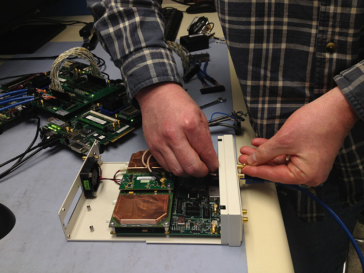
How Navsys Leverages Military Expertise for Business
The financial landscape is changing in a number of ways for a lot of GNSS businesses due to the U.S. government sequester and to a larger extent due to the U.S. reduction in military spending. The larger multinationals and prime contractors may have achieved pretty well diversified scope for their operations, and most have existing commercial products or operations where they can pump up resources and investment to improve their commercial market and product positioning. But a number of small businesses have discovered that their military and government clients of the past no longer have the same level of funding available for key projects. So their search is on for commercial opportunities, and the transition to a commercial business model may present a significant change in the way they operate.
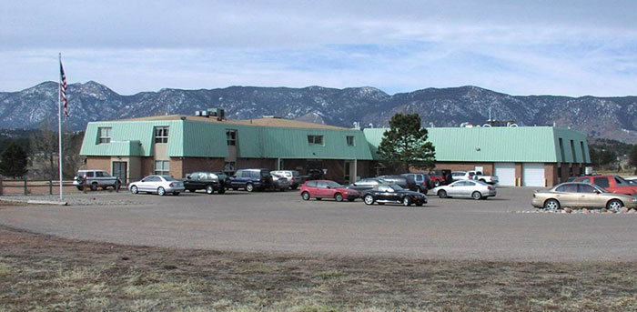
Navsys Corporation in Colorado Springs is located just outside the gates of the U.S. Air Force Academy, so it’s not unusual that its customer base reflects a close association with the U.S. military and its prime contractors.
When someone in the military had a challenging GNSS or related technology problem in the past, it was often Navsys who was able to offer an innovative solution, through a Small Business Innovation Research (SBIR) proposal — and the company was actually awarded nine SBIR Phase II contracts over the last five years. Phase II SBIR contracts are designed to transition mil technology into commercial products either via government organizations or commercial outfits. Often in the past, prime contractors responding to a larger mil-spec requirement would also roll Navsys into their response when part of the requirement involved a GNSS navigation or related solution. So since 1989, the development of GNSS technology and products, and the publication of papers describing those technologies and products, have been pretty continuous at NAVSYS:
Extended wide area differential GPS
WAAS bent-pipe signal generator (SIGGEN)
GPS/inertial video registration
Digital beam-steering GPS receiver
JLOC Jammer Detection and Location system
Indoor location
GPS phased sensor array
Software-defined receiver
JLOC has been a long-term active government project for more than 10 years. SIGGEN technology has been part of Japan’s MSAS system for more than 10 years, and is an example of a successful product that has transitioned from government research into the commercial sector. And, of course, the first GPS-enabled cell phone, developed by Navsys Corporation, is now on display at the Smithsonian National Air and Space Museum’s Time and Navigation exhibition in Washington, D.C. Developed for the Colorado Department of Transportation’s Emergency Vehicle Location System Mayday platform in 1995, this important step in GPS history paved the way for positioning to become an integral component of today’s communications technology.
The complement of professionals on staff at Navsys has changed throughout the years, driven largely by how many projects were contracted at any one time, but the group has always had a very high standard of qualifications and experience and has inevitably exhibited a large degree of flexibility and creativity. Nowadays, moving to better align with commercial opportunities, Navsys helps companies solve challenging problems relating to GNSS, inertial, and simulation/testing. Cultivating business-to-business partnerships allows the company’s technical expertise to compliment and strengthen end-user products or applications. So companies are able to use Navsys as a technical resource for product development at a lower cost than developing their own in-house navigation solutions. And many of the technologies and core capabilities that they turn to stem from prior research and development into government and military applications. As projects mature, they transition into industry-leading products and services. Navsys’ industry partners and customers then go on to customize these capabilities into commercial applications in the marketplace.
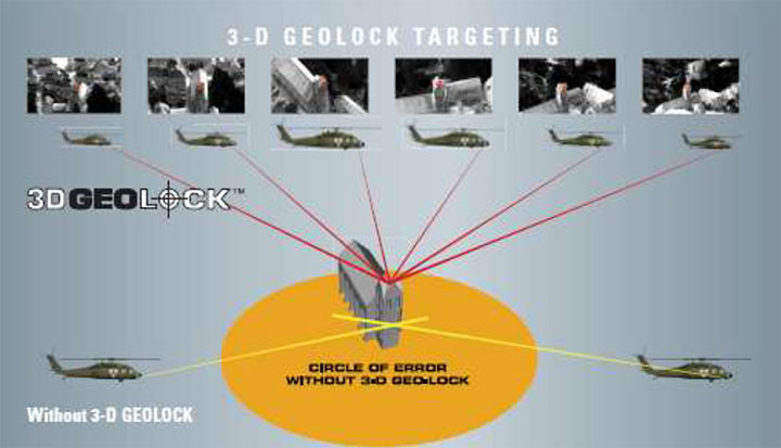
One of the key technology/products that Navsys is pursuing includes InterNav modular GPS/inertial embedded software. It provides a real-time tightly coupled GPS/inertial solution that can be precisely aligned with additional sensors, including digital video products and laser rangefinders.
InterNav software provides geo-registration for SAFIRE. Photo: NAVSYS
InterNav software may be embedded into OEM applications including commercial-off-the-shelf GPS/INS systems, unmanned platform navigation and stabilization systems, and remote sensing geo-registration. The above graphic shows how InterNav provides highly accurate geo-registration for FLIR’s Star SAFIRE electro-optic imaging system.
With other key customers such as KVH also using InterNav in some of its integrated inertial products, Navsys appears to be well on its way to penetrating a market segment that has previously been a space occupied by companies such as Applanix, Teledyne, and iMAR.
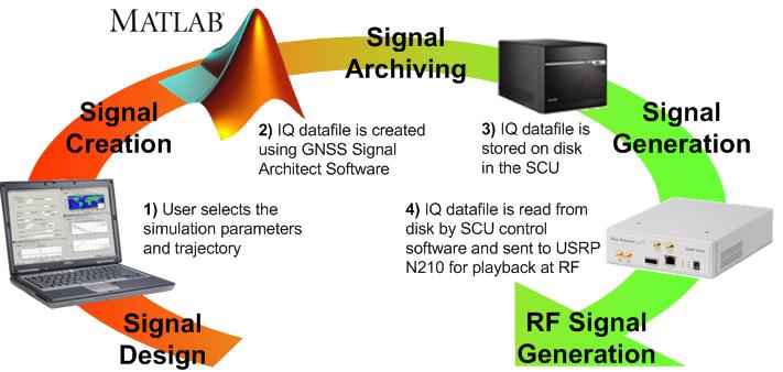
Another area where Navsys has had some success is GNSS simulation and test. The GNSS Signal Architect product suite includes Simulation and Toolbox software and test-set hardware.
Photo: NAVSYS
Simulations of GPS or GLONASS are created based on static or dynamic scenarios. Users specify a complete set of simulation parameters, including receiver/satellite profiles and delay/noise error modeling. Playing back the simulation as an RF signal provides accurate and repeatable signals for GNSS receiver testing.
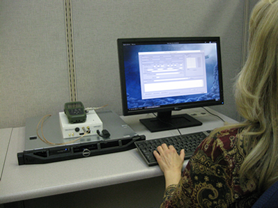
Signal architect user. Photo: NAVSYS
Toolbox includes a number of GNSS MATLAB utilities, including geographical, satellite geometry and receiver design/analysis tools. Test set is made up of a signal control unit computer and a software-defined radio and includes a wideband transceiver daughterboard.
Navsys has in the past provided extremely accurate GPS scenario generation software for end-user GPS simulator products, and the SatGen GNSS signal generator has also been released by Racelogic using Navsys Signal Architect Signal Simulation software.
Other technology/products currently in the works include Precision Geo-Registration and Remote Sensing, Geo-Referenced Imagery, Video-Aided Inertial Navigation and GNSS/Inertial Simulation.
GPS/inertial InterNav technology has been used to develop Precision Geo-Registration and Remote Sensing,which extracts precise coordinates from video imagery without requiring any known data points. The key technology advantage is a precision GPS/inertial alignment technique that enables accurate camera alignment and aiming (<1 mrad attitude) using only low‐grade inertial sensors.
Video-Aided Inertial Navigation uses an algorithm update technique that leverages image aiding from tracking ground points to further refine alignment accuracy. When combined with the GPS/inertial alignment algorithm, significantly improved alignment accuracy can be achieved over current GPS/inertial integration approaches.
Photo: NAVSYS
So, as defense spending continues to contract, Navsys and other similar companies with an existing “treasure chest” of technology created for previous military programs are successfully adapting. Not only are skillfully modified, repackaged or even further advanced technologies and products being brought to the commercial marketplace, but their approach to business development, marketing and sales is beginning to take on the face of commercial operations. Business plans, carefully chosen projects and internal investment are beginning to replace responses to Commerce Business Daily (CBD) and Federal Business Opportunities (FedBizOpps) as a way to conduct business. It’s a brave new commercial world out there and Navsys amongst others is ready, prepared and able to adapt and succeed.
A major exhibition opening April 12, “Time and Navigation: the untold story of getting from here to there,” explores how revolutions in timekeeping over three centuries have influenced how people find their way. This project is a unique collaboration between two of the Smithsonian’s largest and most popular museums: the National Air and Space Museum and the National Museum of American History.
“Time and Navigation is an ambitious exhibit because it traces the development of very complicated technologies and makes us think about a subject we now take for granted,” said Gen. J.R. “Jack” Dailey, director of the museum. “Today, the technology needed to accurately navigate is integrated into mobile computers and phones: hundreds of years of technological heritage tell your handheld device where you are in a seamless manner. This opens up new possibilities and challenging questions for the next generation of scientists and explorers who visit this exhibit to start thinking about.”
The gallery is organized into five sections and spans three centuries of efforts to travel on Earth and through the solar system. In each section the visitor will learn about pioneer navigators facing myriad issues, but one challenge always stands out: the need to know accurate time.
Sections
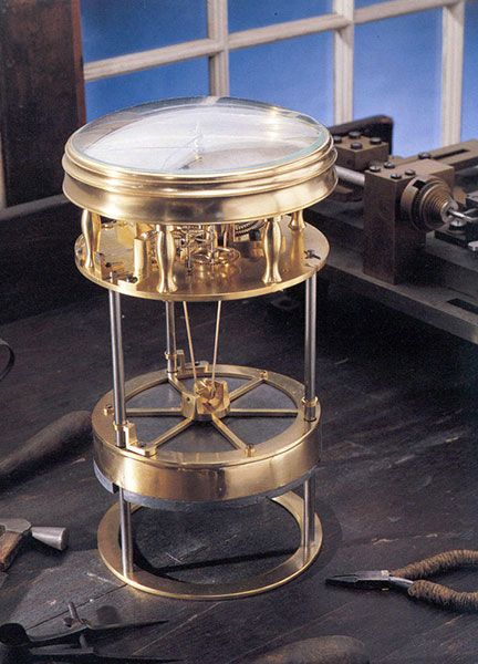
This timekeeper was the first American-made marine timekeeper taken to sea. William Cranch Bond, a 23-year-old Boston clockmaker, crafted it during the War of 1812.
Navigating at Sea is an immersive environment that suggests a walk through a 19th-century sailing vessel. Visitors will learn how centuries ago navigators at sea relied on chronometers and measurements of celestial objects to determine location. This section includes a mariner’s astrolabe, dating from 1602; a Ramsden sextant and dividing engine; several chronometers; a model of Galileo’s pendulum clock; and the earliest sea-going marine chronometer made in the United States, produced by Bostonian William Cranch Bond during the War of 1812. It also features an interactive display that allows visitors to use a sextant to navigate with the stars.
Navigating in the Air relates how air navigators struggled with greater speeds, worse weather and more cramped conditions than their sea-going predecessors. It tells the story of the innovations that overcame these challenges, as represented the gallery’s largest artifact, the Lockheed Vega “Winnie Mae,” flown by Wiley Post and Harold Gatty, shattering the around-the-world record in 1931. Visitors will learn that Charles Lindbergh required navigational tutoring after he flew to Paris and how he paved the way for a new system of navigation in the process. A personal account by a WWII navigator highlights wartime innovations. This section ends with an explanation of how clocks with tiny quartz crystals opened an entirely new era of navigation in the form of LORAN (LOng RAnge Navigation).
Wiley Post’s Winnie Mae circled the globe two times, shattering previous records. The first time was in 1931 with Weems associate Harold Gatty as lead navigator. The second was a solo flight in 1933 assisted by “Mechanical Mike,” one of the world’s first practical autopilots.
Navigating in Space traces how teams of talented engineers invented the new science of space navigation using star sightings, precise timing and radio communications. This section includes an Apollo sextant, a space shuttle star tracker, timing equipment used at a ground tracking station and a flight spare (duplicate spacecraft) of Mariner 10, the first spacecraft to reach Mercury.
Inventing Satellite Navigation describes how traveling in space inspired plans to navigate from space. Innovators found that time from precise clocks on satellites, transmitted by radio signals, could be used to determine location. The U.S. military combined several breakthroughs to create the Global Positioning System. Some of the artifacts in this section are the NIST-7 atomic clock that served as the U.S. time standard in the 1990s, the navigation system from the nuclear submarine U.S.S.Alabama, a satellite from the Transit system used for global navigation before GPS and a test satellite global navigation built at the Naval Research Laboratory.
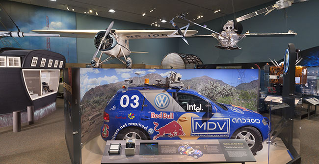
An official DARPA photograph of Stanley at the 2005 DARPA Grand Challenge. Stanley, created by the Stanford University Racing Team, won the race.
Navigation for Everyone tells the stories of real people — a fireman, a farmer and a student — who use modern navigation technology in their everyday lives. It also addresses what might come next: the story is not over yet and many new technologies are being developed. This section includes a disassembled mobile phone with a diagram showing all its parts and depicts how hundreds of years of navigation technology are now in the palm of a user’s hand. It also features “Stanley,” the robot car that won the 2005 Grand Challenge, a robot race sponsored by the Defense Advanced Research Projects Agency.
The exhibition is made possible through the support of Northrop Grumman Corporation; Exelis Inc.; Honeywell; National Geospatial-Intelligence Agency; U.S. Department of Transportation; Magellan GPS; National Coordination Office for Space-Based Positioning, Navigation and Timing; Rockwell Collins; and the Institute of Navigation.
The National Air and Space Museum building on the National Mall in Washington, D.C., is located at Sixth Street and Independence Avenue S.W. The museum’s Steven F. Udvar-Hazy Center is located in Chantilly, Va., near Washington Dulles International Airport. The National Museum of American History collects, preserves and displays American heritage in the areas of social, political, cultural, scientific and military history.
Bradford W. Parkinson, professor of Aeronautics and Astronautics Emeritus at Stanford University, discussed “GPS for Humanity — The Stealth Utility” at a special Smithsonian event Thursday, March 21. If you missed his talk, you can view it now on UStream.
According to the Smithsonian, for centuries, nations have invested enormous resources to determine time and place for geopolitical reasons, and their research has changed people’s view of the world. Advanced technology that was once available only to the military has become commonplace in car dashboards, cell phones and a growing number of other portable devices of daily life. The Time and Navigation exhibit explores how revolutions in timekeeping over three centuries have influenced how people find their way. It is organized into five sections: Navigating at Sea; Navigating in the Air; Navigating in Space; Inventing Satellite Navigation; and Navigation for Everyone.
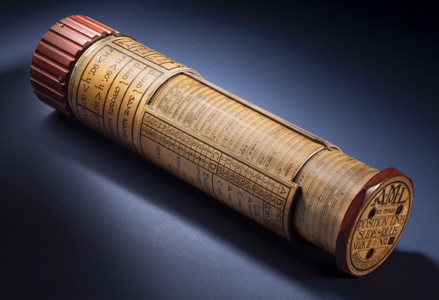
Bygrave Position-Line Slide Rule.
Andrew Johnston (geographer, Center for Earth and Planetary Studies, National Air and Space Museum) gave a presentation about the exhibit at ION GNSS in Nashville, Tennessee.
In the 1970s, Parkinson was the chief architect and original program director for GPS. In his lecture, he will present the history, applications, and future of GPS and the GNSS. Central to operation of GPS is the relationship between time and navigation, and GPS will be explored in the Time and Navigation exhibit.
U.S. Air Force Space Command has issued a notice that CNAV capabilities on the GPS L2C and L5 signals will be tested in June. No GPS satellite outages are planned. Below is the official notice.
Notice of Test
A Notice by the Air Force Department on 03/20/2013
Action: GPS Test Notice.
Summary: The purpose of this notification is to inform users of an upcoming event related to the GPS satellite constellation. U.S. Air Force Space Command will be testing CNAV capabilities on the GPS L2C and L5 signals on 15-29 June 2013. There are no planned GPS satellite outages for this activity. The broadcast navigation messages will be in compliance with IS-GPS-200 and IS-GPS-705. L2C/L5 CNAV testing will be transparent to GPS receivers that do not process L2C or L5 CNAV. U.S. Air Force Space Command expects to conduct one to two CNAV tests per year over the next few years. These test events will provide an opportunity for civil users and manufacturers to participate in L2C/L5 evaluation and will result in enhanced provider and user readiness for L2C/L5 operations once the Next Generation GPS Operational Control System comes online in 2016.
The draft test plan is available. The draft test plan communicates details of the broadcast, data collection, and results reporting plans.
U.S. Air Force Space Command and the National Space-Based Positioning, Navigation, and Timing Systems Engineering Forum (NPEF) encourage L2C and L5 users and receiver manufacturers to review the test plan, provide comments, and participate in the evaluation process.
Any military or civil users who encounter user equipment problems during or after testing should contact the GPS Operations Center (GPSOC) (military), NAVCEN (civil, non-aviation) as soon as possible. Aviation users should file reports consistent with FAA-approved procedures.
FOR FURTHER INFORMATION CONTACT:
Send all questions or concerns regarding the CNAV Test Plan to [email protected].
Henry Williams Jr.
Acting Air Force Federal Register Liaison Officer
ITT Exelis has been awarded a $2.15 million contract by the Air Force Research Laboratory (AFRL) to research the development of a small satellite navigation payload to augment the current GPS program. The GPS NAVSAT (Navigation Satellite) program seeks to provide affordable capabilities to aid end-users located in tough-to-reach environments.
“The development of smaller satellites — in terms of size, weight, power and cost — will yield greater affordability for our customers,” said Mark Pisani, vice president and general manager, Precision Instruments and Positioning, Navigation and Timing Systems, ITT Exelis Geospatial Systems. “A smaller satellite size will allow for improved launch vehicle selection flexibility.”
The goal of the 18-month initial study is to identify innovative ways to increase affordability and sustainment of the GPS program through payload weight reduction, size and power. The GPS NAVSAT will maintain similar performance capability to the existing GPS system, but will aid GPS end-users in signal-constrained environments, located in urban or mountainous terrain.
Work on GPS NAVSAT is performed in Clifton and Bloomfield, New Jersey.
For nearly 40 years, Exelis payloads and payload components have been on board every GPS satellite with more than 500 years of on-orbit life without a single mission-related failure due to Exelis equipment.
GPS IIF pulse line Boeing is building 12 Air Force GPS IIF satellites on its innovative pulse line at the Satellite Development Center in El Segundo, CA. The pulse line enables simultaneous construction of multiple satellites, increasing savings, quality and efficiency. Photo credit: The Boeing Company
The Boeing Company has completed the fifth of 12 Global Positioning System (GPS) IIF satellites the company is building for the U.S. Air Force. The spacecraft was built at the Satellite Development Center in El Segundo using the GPS IIF pulse-line manufacturing approach, which draws on commercial production line practices to build satellites faster and more efficiently.
Of the five completed GPS IIF satellites, two are on orbit as part of the current 31-satellite constellation; both satellites are meeting mission requirements. Three satellites are in storage on standby for launch by the Air Force. The remaining seven are in various stages of pulse-line production and will likely be added to the constellation over the next three to five years as determined by the Air Force to ensure robust constellation availability.
"Boeing, in close partnership with the U.S. Air Force, is focused on execution and mission assurance — we are committed to sustaining the GPS constellation with GPS IIF," said Craig Cooning, Boeing vice president and general manager of Space & Intelligence Systems. "The GPS IIF spacecraft feature more capability and improved mission performance for the warfighters and civilians who depend on this critical system."
The next GPS IIF launch is scheduled for the fourth quarter of 2012. The satellite will be launched aboard a United Launch Alliance Delta IV vehicle from Cape Canaveral Air Force Station, Florida.
GPS is a space-based, worldwide navigation system providing users with highly accurate, three-dimensional position, velocity and timing information 24 hours a day in all weather conditions. GPS IIF satellites provide enhanced capabilities, including a jam-resistant military signal, greater accuracy through improved atomic clock technology, and a protected, civilian L5 signal to aid commercial aviation and safety-of-life applications. Boeing also is the prime contractor for the GPS Operational Control Segment, which has supported an expanding set of GPS services and capabilities since 2007.
The U.S. Air Force says defense contractor Lockheed Martin will lose its entire fee of about $70 million to defray an 18 percent cost overrun on the first of its newly designed GPS III satellites, theWashington Post reported.
Lockheed had estimated that it would cost $1.5 billion to develop, test and build the first two GPS III satellites, but Air Force spokeswoman Vicki Stein said the cost had risen to $1.62 billion.
The new GPS III satellites are designed to deliver more accuracy, an anti-jamming capability and a civilian signal that can operate with Europe’s Galileo system.
Sensor Modeling and Sensitivity Analysis for a Next-Generation Time-Space Position Information System
By Mark Smearcheck and Michael Veth, Air Force Institute of Technology
Increasing availability and performance of state-of-the-art navigation sensors motivates the need for a highly accurate reference system commonly referred to as a time-space position information (TSPI) device. The Advanced Navigation Center at the Air Force Institute of Technology is working with the Air Force Flight Test Center to develop a next generation time-space position information (TSPI) system to be used for test and evaluation of modern navigation devices.
TSPI systems such as the GPS Aided Inertial Navigation Reference (GAINR) or Advanced Range Data System (ARDS) accompany navigation sensors during flight testing to collect the precise position, velocity, and attitude. Current GAINR TSPI performance levels include 1.0 m of position uncertainty, 0.1 m/s of velocity uncertainty, and 1.75 mrad of attitude uncertainty. Goal performance levels for next-generation TSPI call for an order of magnitude improvement over current systems.
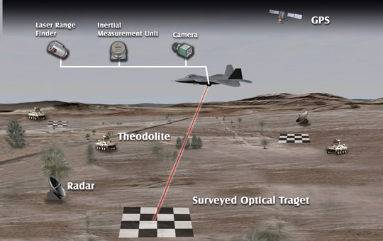
A more accurate test and evaluation device will likely require fusion of multiple sensors of varying modalities such as GPS, inertial, electro-optical and infrared cameras, laser range sensors, barometric altimeters, ground-based theodolites, and ground-based tracking radar. This research aims to identify an integrated sensing package and the sensing techniques required to achieve the next generation TSPI accuracy.
In order to accomplish this task, a sensitivity analysis is performed that predicts the quality of the navigation solution attainable using various external sensor combinations. The sensitivity analysis requires sensor characterization and modeling in addition to development of a software simulated world (the flight test range) that the sensors are able to observe. Issues also investigated in this research include vision-aiding techniques, optical feature deployment, and testing in GPS-denied scenarios.
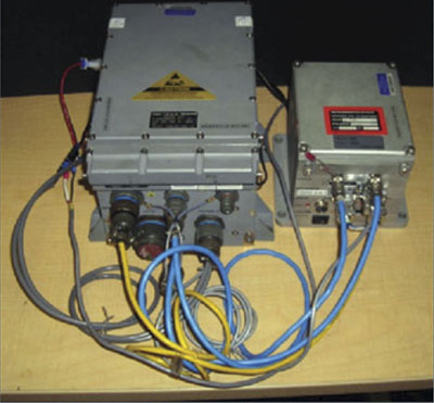
The GPS Aided Inertial Navigation Reference (GAINR) system consists of a Honeywell 764-G embedded GPS/INS with a custom control and recording unit. The data are post-processed using an optimal smoother and differential GPS measurements.
Sensors and Simulated World
The Air Force Flight Test Center currently obtains TSPI using the GAINR, which includes a navigation grade inertial measurement unit (IMU) and dual-frequency code-based differential GPS (DGPS). Carrier-phase GPS, if available, could be implemented to increase position accuracy.
When integrated into a highly dynamic platform, such as tactical fighter, a kinematic solution may not always be obtainable due to difficulty resolving integer ambiguities and cycle slips experienced in the receiver’s tracking loops. The sensitivity of both code and carrier-phase differential GPS is included in this research due to the uncertain availability of a kinematic solution.
Scenarios of GPS denial are always an area of concern for the warfighter, and thus GPS-independent test-platforms must be examined. Other positioning sensors, useful in GPS-denied testing, include ground-based theodolites and radars. These devices are installed at surveyed locations on the test range and are used to track the test aircraft. Theodolites are pivoting platforms that may contain various sensors and provide range, azimuth angle, and elevation angle measurements. Radars are also used to provide the same type of measurements, along with an additional velocity measurement (Figure 1).
Figure 1. Overview of possible TSPI sensors. The sensors consist of both aircraft-based and ground-based devices.
Onboard optical sensors including high-resolution digital cameras and laser range finders have also been investigated for TSPI use. This research proposes to install surveyed targets on the test range that are easily identifiable through feature extraction and tracking methods such as the scale-invariant feature transform (SIFT).
Cameras are able to observe position and attitude through homogenous pixel location measurements of image features (FIGURE 2).
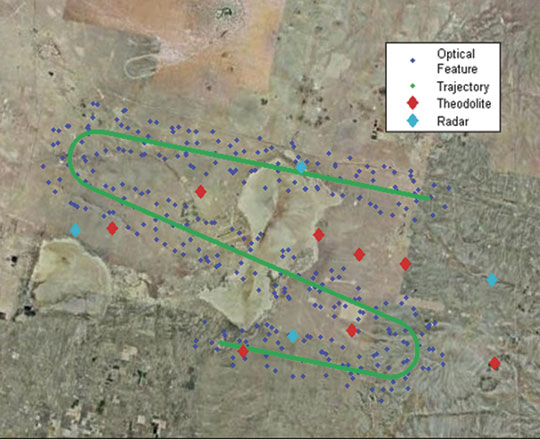
Figure 2. Simulated test range at Edwards AFB that includes optical targets, ground sensors, and a flight test profile. Optical landmarks are randomly spread within the field of view of the optical sensor over the trajectory.
An objective of this sensitivity analysis is to show the attitude performance achievable through feature tracking of surveyed targets. When image-aiding of an IMU is implemented in a navigation filter, such as the extended Kalman filter (EKF), next generation TSPI level attitude accuracy should be reached.
The other optical sensor investigated, the laser range finder, is used to augment the navigation solution by measuring distance to the surveyed targets detected by the camera.
For the sensitivity analysis a simulated world is generated for the sensors to make observations. The world simulation includes GPS ephemeris, a digital terrain elevation database (DTED), gravity models, natural terrain landmarks/targets, manmade targets, a ground sensor deployment map, simulated flight test profile, and vehicle sensor installation lever-arms.
Sensitivity Analysis
The goal of the sensitivity analysis is to determine the minimal set of sensors that will meet next generation TSPI performance requirements. Sensor models and world characteristics are used to calculate expected position, velocity, and attitude uncertainty given a particular trajectory, sensor package, and feature set. The aircraft’s state vector, , as a function of the measurement, z, and uncertainty matrix, R, is represented as
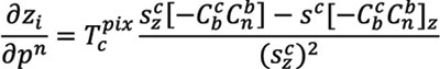
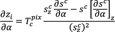
where H is the observation matrix. The observation matrix is a Jacobian made up of partial derivates of each sensor’s measurements with respect to position, velocity, and attitude. Example H matrix elements include the partial derivates describing the camera measurements with respect to position and attitude. The partial deviate of the pixel coordinate, zi, of an image feature with respect to position, pn, is
where Tcpix is the camera frame to pixel frame transformation matrix made up of calibration parameters, sc is the line of sight vector from the camera to the target expressed in the camera frame, Cnb and Cbc are direction cosine matrices, and the subscript z denotes the z dimension of the indicated navigation frame. The partial derivative of the pixel coordinate of an image feature with respect to attitude, α, is calculated as
The H matrix’s partial derivatives describing observations from other navigation sensors are derived in our previous
work, “Sensor Modeling and Sensitivity Analysis for a Next Generation Time-Space Position Information (TSPI) System,” Proceedings of the ION International Technical Meeting, 2010. The a posteriori uncertainty of the state or sensitivity, P, at time k is calculated as
where P0 is the initial uncertainty.
Results
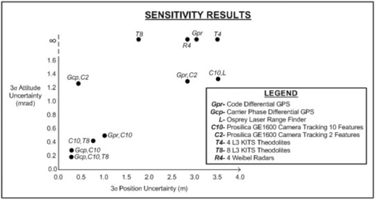
Results show the three sigma median uncertainty of position and attitude for various sensor combinations over a common flight profile through the test range (Figure 3).
Figure 3. Sensitivity analysis results of position and attitude with various sensor combinations. Scenarios of unobservable attitude are designed by the infinity symbol.
Conclusions
The sensitivity analysis indicates that the most practical sensor package that meets next-generation TSPI performance is the combination of carrier-phase GPS and a high-resolution camera tracking ten SIFT features per image.
In this example, tracking only two SIFT features per image does not provide the necessary level attitude accuracy, although incorporating inertial measurements is expected to reduce the overall number of features required per image.
In the absence of GPS, theodolites when coupled with a camera can function as a reasonable alternative. It should be noted that since the sensitivity analysis relies on a simulated world the feature tracking performance and target surveying accuracy may change during operational testing.
The next phase of this research is to integrate the sensors with an IMU using an extended Kalman filter. Fusion with a navigation-grade INS is expected to improve position, velocity, and attitude accuracy.
If simulated results are promising, the next phase of the effort will focus on collecting flight test data to validate the simulation and further increase the fidelity of the simulation.
Acknowledgment
The authors would like to thank the Air Force Flight Test Center for supporting this research.
MARK SMEARCHECK is a research engineer with the Advanced Navigation Technology Center at the Air Force Institute of Technology (AFIT) at Wright Patterson Air Force Base in Dayton, Ohio. He received his B.S. in electrical engineering in 2006 and his M.S. in electrical engineering in 2008, both from Ohio University. His research topics include micro-air vehicles, indoor navigation, image-aided navigation, pseudolites, and test range instrumentation.
LT. COl. MICHAEL VETH is an assistant professor of electrical engineering at AFIT and deputy director of the Advanced Navigation Technology Center. He received his Ph.D. and M.S. in electrical engineering from AFIT and his B.S. in electrical engineering from Purdue University. He is a graduate of Air Force Test Pilot School.
The first time I ever heard of the Magnavox Research Laboratory in Torrance, California, was in 1966, as a young engineer working at Hughes Aircraft. We were building large (46-foot diameter) ground stations for the Defense Satellite Communications System (DSCS). Magnavox was supplying the secret anti-jam modems used in the terminals.
Because of this, I also learned a little about spread-spectrum pseudo-noise (PN), something quite esoteric at the time and not taught in engineering school. I noticed a widespread respect for Magnavox from my colleagues who referred to the company and its equipment as “Magicbox.”
Within a year I had transferred to the Hughes division responsible for developing satellites. We were working on a study known as 621B, for using satellites for positioning. Our teammate for the study was Magnavox. That team was responsible for the payload signal design, for which the team chose PN as the modulation to provide for multiple access, ranging, data transmission, and anti-jam.
Before long, my boss decided to leave Hughes and go work for Magnavox. He took two of his systems engineers with him. I was one of them.
In1968, the U.S. Air Force could not yet sell the 621B concept as an Advanced Development Program, so instead opted to experiment and prove that PN modulation could be used to accurately measure a half-mile of cable. Hughes bowed out since there wasn’t any satellite procurement in the offing. Magnavox and the other 621B contractor, TRW, each took on the challenge of measuring the cable.
Where Hughes had been 10-deep in Ph.D.s in every discipline, Magnavox was 10-deep in PN experts, which I believe at that time was the world’s majority. Thus it was natural for the Air Force to ask them to continue, and develop a receiver to be used in the next phase of 621B. An inverted range was set up with four PN transmitters, and an aircraft with the receiver and a bottom antenna flew over them. The aircraft’s position was determined using the PN range measurements and the known locations of the transmitters. The data from that receiver, called the MX450, was used to help justify the Department of Defense (DoD) decision to proceed into the Advanced Development Phase of GPS. Some of the people who contributed to this were named in Dr. Brad Parkinson’s recent articles on the origins of GPS. During that time I was working on the next generation of spread-spectrum modems for the DSCS.
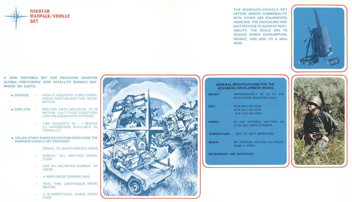
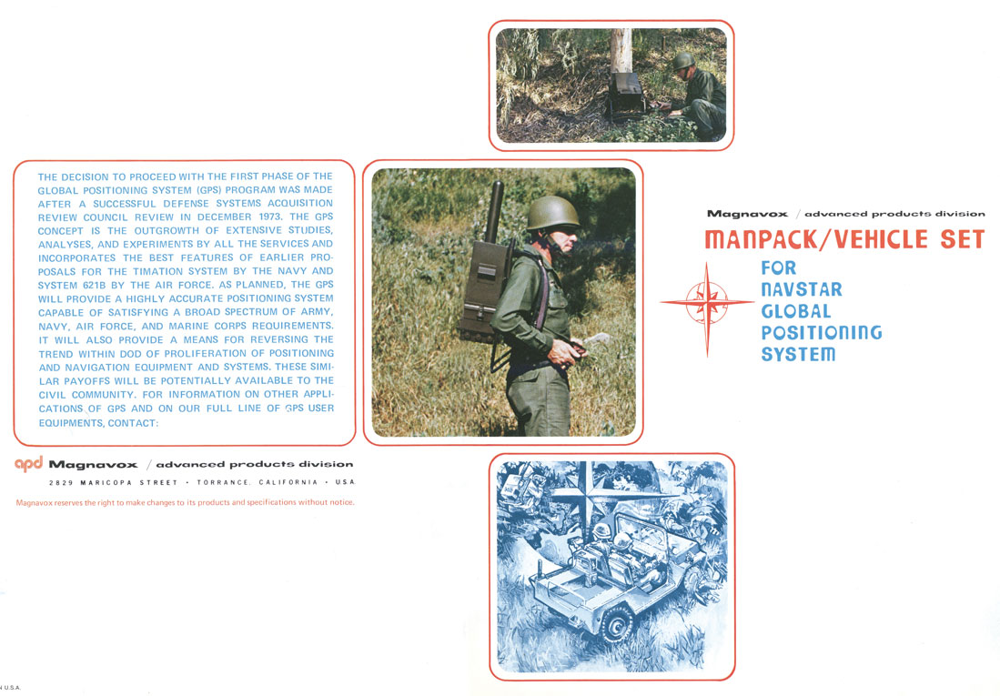
Magnavox went on to develop these PN satcom modems for all three services, and thus was a natural choice to develop the first military GPS receivers (known as X and Y sets and the first Manpack), as well as the first C/A receiver, the Z set, and the very first spaceborne receiver called GPSPAC.
As soon as we completed the first Manpack, I approached Col. Paul Weber, the Joint Program Office Army Deputy Program Manger, and asked if he would pose with the Manpack on his back for a brochure we wanted to produce to show to potential Army and Marine Corps users. He agreed, dressed in his combat uniform, and went with our photographer into the wild woods of San Pedro (near the Port of Los Angeles) for the picture shown in the brochure.
Magnavox also developed the military GPS Engineering Models in competition with Rockwell Collins. Magnavox lost the production contract to Rockwell Collins a year after I left to join IEC, now known as L-3 Communications.
Magnavox also pioneered commercial GPS sets for use in the marine and survey markets. Today, you will still find many of the original GPS user equipment developers still at it as consultants and engineers at Raytheon, Navcom, Trimble, IEC, and others. Perhaps our most famous alumni is Dr. Min Kao, the “min” of Garmin.
Len Jaconbson
LEN JACOBSON is a consultant to the GPS industry and has served as an expert witness in many legal proceedings involving GPS. He is the author of the book GNSS Markets and Applications, published in 2007, and is a longstanding member of this magazine’s Editorial Advisory Board.
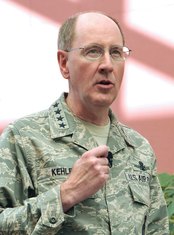
General C. Robert Kehler, Commander of the U.S. Air Force Space Command
Editor Don Jewell Talks with the Air Force General Heading Space Command: His Views, Use, and Plans for GPS
Defense editor Don Jewell is a retired Air Force officer who served for 30 years; many of his former peers and contemporaries are currently senior officers in today’s U.S. Air Force. Don sat down recently with General C. Robert Kehler, Commander of the U.S. Air Force Space Command, whom he has known and worked with for more than 20 years, to discuss GPS from the four-star point of view.
Don Jewell (DJ): General Kehler, thanks for taking the time to have this discussion today. I would like to keep this very informal, more of a conversation, like the days when you and I and Willie Shelton [now Lt. Gen. Shelton, USAF] sat around on your lanai, sharing a brew, telling war stories, and solving the world’s problems.
General Kehler (GK): Believe me, Don, there are days when I wish we were still doing that. I appreciate the opportunity to have a conversation with you.
DJ:Great. Sir, to get to the crux of the matter, as the senior warfighter for space, how do you see GPS in the future, and how does it contribute to the joint fight?
GK: Don, you know this, as may many of your readers at GPS World, but I don’t believe we can say it often enough: GPS is the primary source of position, navigation, and timing (PNT) information for the Department of Defense, and it will remain that way at least until the year 2030. This has been a remarkably successful program, supporting the joint warfighter in nearly every aspect of joint operations. How GPS supports joint operations, whether it’s the individual soldier, sailor, airman, Marine, or Coast Guardsman, who is on the ground or inflight or who happens to be in the dark in a mountainous region somewhere or in the flat expanse of the desert — it doesn’t much matter. GPS has been their constant companion now for many years. They have come to rely on GPS in ways that help them do their job better, and it allows them to perform missions that in the past they would not have been able to perform in this kind of a manner, with this kind of perfectness.
GPS is going to remain the foundation of the PNT strategy. And with the modernization effort that we have underway in GPS, we are going to make sure that it remains the world’s premier source of position, navigation, and timing information, and in particular that it remains woven through the fabric of the joint warfighting network.
DJ:This portends an excellent future for GPS, despite comments by the Air Force Chief of Staff and Gen. “Hoss” Cartwright, vice chairman of the Joint Chiefs of Staff, that we should move away from GPS. Do the Chief’s comments cause you any concern?
GK:They do not cause me any concern. We are committed to keeping GPS the gold standard. We have a commitment in that regard. I understand exactly what the Chief of Staff said and why. I will be happy to discuss that more.
DJ: We’ll table that for now, and get to it later if we have the time. I have often heard you say in your GPS update and status briefings that GPS is one of your good systems. Indeed, you have described it as one of the systems you don’t have to worry about too much, because it works. It would be interesting to ascertain how you know when you are doing a good job with GPS. How do you know it works? For example, do you receive comments, e-mails, or letters from warfighters?
GK: I think there are really two big ways that we know we are doing a good job with GPS. First of all, we measure our performance against the standard. What the users see, of course, is accuracy and satellite availability. Those have become our two primary standards. We make sure we are performing up to those standards. And in fact, as you know, we continually outperform those documented standards and the requirements that we have.
We also look, not only at the satellites, but at the ground command and control (C2) system and the ground support network. We make sure those elements are always up and running as well. From a numbers standpoint, from a “how well are we meeting the standards we have set for ourselves” standpoint, we exceed those standards. We exceed in terms of accuracy and availability, both the satellite system and the ground-supporting infrastructure as well.
But these days, I will tell you, I think the numbers are interesting, but what I think we look at just as hard is how the public talks about GPS.
And if you look today, GPS, at least in my opinion, is everywhere in the public conscience. I was saying earlier today, you really don’t have to go much farther than your television set. Almost any evening you turn the TV on you’ll hear something about GPS. You’ll either hear people who are equating their product to GPS, or you’ll hear in a television show someone mention GPS or their GPS device. And that is without it being a program about the satellites themselves, or the U.S. Air Force, or the things we do at Schriever Air Force Base to make it all work.
My view is that the fact that we get this informal public feedback constantly, and that it’s positive, says a lot about how good a job we are doing as well. When your program becomes a new word in the English language, I think that says something about success. Any more, if you say GPS to people they might not point to a satellite, they might point to the little device they are holding in their hand, but they understand somebody is providing that for them and that it is working well.
The final piece to that is also our civil partners. You know we have a GPS Executive Committee (PNT ExCom) inside the government that meets periodically to have conversations about the way ahead on GPS for the entire government, and by extension for the United States. The feedback that we get at those meetings, and unfortunately I can’t get to every one of them, but in those that I have attended, the feedback has been universally positive.
We just had a Civil Focus Day recently, and the feedback we got was universally positive. Are there things we can do better? Yes, of course there are, there are always things you can do better, but I can tell that we are doing a good job with GPS, not only because of the numbers that we look at but because of the feedback that we get, and the way GPS has been accepted and adopted, if you will, as part of the lexicon.
DJ: You’re absolutely right about the positive feedback. I attended Civil Focus Day, wearing a different hat, as you know, and I agree, everybody was onboard and positive about GPS.
The next topic revolves around how your scorecard is graded by the joint community, and do you have a way of actually getting feedback from the warfighter?
GK: Yes, as I said, we are graded or we grade ourselves primarily on accuracy and availability as they are documented for us in the performance standards. In watching those numbers, we know that we are exceeding the performance standards that we set for ourselves. But we also receive feedback directly from the warfighters. We receive feedback from the military users through the GPS Operations Center (GPSOC). You know, and I think most of your readers know, that there is a way that you can directly contact what we call the GPSOC 24 hours a day, seven days a week, and we find that both our military and civilian users do that.
Another way that we receive feedback is through the Coa
st Guard Navigation Center (NAVCEN), where they are specifically watching and helping us watch the performance of GPS. We get feedback directly from them as well. But much like the prior topic, there are also other ways that we get feedback.
For example, in each of our theaters of operations, for each of our combatant commanders, the joint or combined force air component commander is also designated as the space coordinating authority. And working for that space coordinating authority in the AOC (Air Operations Center) is someone called the director of space forces, an Air Force officer who is responsible for making sure that the space support is there when it needs to be and in the fashion that it needs to be. Those directors of space forces also have a small staff working with the combined force air component commanders.
They are getting direct feedback from the warfighters as well. They are either getting it as a normal course of business, on a day-in day-out basis, or they are asking for it specifically as well. We are also getting direct feedback from the units themselves. We have made contact through a number of our forward space people. We work with Army Space and Missile Defense Command and as a matter of fact we have talked with the Marines and others directly. We don’t wait for their feedback, we go out and solicit it also, and we actually help them solve some very difficult problems that we had early on in the conflict with some of our weapons systems that we have now fixed.
We are mindful, we know when certain operations are underway, we deconflict that with activities in the [GPS] constellation, making sure that we are providing the very best service all the time. We are embedded through the planning process in the theaters with military operations and with space professionals who are in the planning cells and Air Operations Centers. We are very comfortable. We are getting constant feedback from the warfighters in addition to the scoring we do ourselves and against the performance standards.
DJ: As you know, in many of my articles I frequently comment that where GPS is concerned, geometry and numbers matter. In that regard you recently approved a 24+3 GPS constellation change. Now we get a good many letters from warfighters at GPS World, and some letters are all about GPS accuracy as you spoke of earlier, but actually more letters mention GPS availability as being critical. Where do you stand on the debate of what is more critical, accuracy or availability, as far as the warfighters are concerned?
GK: We don’t separate the two children here, availability and accuracy. Obviously, it doesn’t mean a lot to us if you have high availability and not high accuracy, or if you have high accuracy and not high availability. They go together, and we work both of those issues. We try to make sure that we have the highest availability and accuracy. The accuracy numbers have been very good, as you know. We have been trying to improve availability, particularly for users in impeded environments. We are doing that by taking advantage of the largest constellation of operational GPS satellites we have ever had on orbit. We have begun to adjust the way we have configured the on-orbit constellation.
You called it 24+3, and we were all calling it 24+3 for a while. Now we are calling it Expandable 24, because those are the words that are actually in the Standard Positioning Service Performance Standard. We are expanding the available operational useful slots from 24 in the constellation to 27, and that movement is underway. This should result in improved availability for users in challenged areas like mountainous terrain, deep canyons, and in some cases urban terrain. It improves those kinds of availability numbers worldwide for everyone, for all users. This is not just for warfighters, it’s for all users.
We have begun the movement of the satellites (SVs), and because we are trying to balance on-orbit longevity with movement, it will take us a period of months to move the satellites to the new locations. That movement is underway, and the availability numbers should begin to improve as the movement begins; you don’t have to wait until they are all in their final locations.
By the way, as an aside, just last night, I was driving in Washington [D.C.] and I was using the navigation feature in my cell phone. One of the things it tells you is how many satellites are in view as you are driving along. Now, just to be clear, I was not driving, I was a passenger in the car, so I was not distracted by trying to drive. But I sat there with the thing in my lap, watching it while we were driving through the streets of Washington, D.C., and there were never less than nine satellites in view. At best I noticed that there were 12.
So I thought about that for a minute. Half of the constellation was occasionally in view as we were driving around the streets of Washington. This is pretty powerful, and we are talking about availability. I sat there thinking to myself, yo, if we can help somebody out there — turn that availability when they need it into the right number of satellites — this is a pretty powerful movement that we’ve got going.
DJ: It is, and what you just said about being in the back of the car reminds me about what General Chuck Horner (USAF, ret.) said after he retired as commander in chief, Space Command. He said you know you are truly retired as a four-star general when you go out and get in the back of the car in the morning, and nothing happens.
GK: You’re exactly right. I have a new officer aide who had never been stationed in Washington, and can’t survive in Washington without some kind of a GPS navigation device. He had one going in the front seat, and I had mine going in the backseat, and we were comparing notes as we drove along. It really is pretty remarkable.
DJ: Our readers will he happy to hear that you also have dueling GPSs. I have readers write and say they have up to three or four going at one time on long trips, comparing different GPS device accuracies and interfaces.
GPS has truly been a life-changing event for many of our users, especially the warfighters. I receive hundreds of letters and e-mails from warfighters and this move to Expandable 24 is meeting with unanimous approval.
GK: That’s good to know, and I must say that originated here. Actually, that originated with the IRT [GPS Independent Review Team], as you well know. We then took that to Strategic Command, and Strategic Command embraced it. General Chilton embraced it immediately, and I think that we have done the right thing here. The downside risk here did not outweigh the positive impact that we think we can have on people who need expanded availability.
DJ: Sir, as I said before, wearing a different hat, I attended your Civil Focus Day and I thought it was outstanding. Do you have any comments you would like to make concerning that event, and do you think you achieved your goals?
GK: We did achieve our goals, because our primary goal is improving communication and cooperation, as well as making sure we’ve got a stronger working relationship between the civil and military GPS communities. In that regard I think our goal was achieved. We addressed a lot of crucial concerns that impact both communities. We emphasized that the ongoing GPS modernization and enhancement efforts are going to be transparent to the civil users, and in fact will result in pretty dramatic improvements for civil users:more signals and other enhancements that I think are going to be useful as time goes by. In that regard I was very pleased.
We had a number of very senior people throughout the government who expressed their interest in GPS with their attendance. We had seen, as you know, additional commitment from some of the other [U.S.] government agencies to be supportive in helping to invest in GPS, which I think is very positive. I just think that in general terms we want to make ourselves more transparent in terms of how we are dealing with the constellation and the future of the constellation.
We recognize in Air Force Space Command the unique role that we have for this global utility that the United States of America provides free of charge for everyone else on planet Earth. We recognize that with the use of this and the increasing impact it has on all our lives, comes a unique responsibility for stewardship. We have embraced that responsibility, and that means we have to be transparent and we have to have a collaborative team that we work with, and that was a large part of the Civil Focus Day.
DJ: Many of the proposed systems that may or will one day compete with or complement the GPS are on hold, delayed, or still not at full operational capability. What is your viewpoint on where we stand in relationship to these systems, such as GLONASS, Galileo, and Beidou, for example?
GK: Our objective from an Air Force standpoint has been to support the U.S. government’s goal of wanting to engage in cooperative activities related to space-based PNT, and I think the focus of that cooperation has been to try and ensure that we have compatibility between GPS and other space-based PNT systems. There is a goal on our part to make sure we can be compatible and interoperable. There is a goal on our part to make sure we are protecting our national security interests and that we are maintaining a level playing field in the global market for space-based PNT goods and services.
Those are our objectives, those are the national objectives of the U.S., and the Air Force is supporting those objectives through our management and operation of the GPS constellation. That will continue to be our posture: to make sure, as best we can, to have fostered successful relationships on space-based PNT.
DJ: You certainly can’t ask for more than that. The objectives are laudable, but on the surface they don’t necessarily fit well with the recent comments by the chief of staff of the USAF, and I guess that brings us to the topic we briefly discussed earlier. Do you fully understand where the chief was going with his comments concerning GPS at Tufts University last month, and do you have any comments that might help our readers put the chief’s remarks in the proper perspective?
GK: I do. I was present when General Schwartz made his comments, and honestly I understood what he was saying and why. I think that he was misunderstood in implication. I think what he said was misapplied by some. In my view, General Schwartz fully supports GPS. What he was doing, though, is he was talking about GPS and its value for military operations.
What we know is that, like any other military capability that we rely on for important pieces of our warfighting force, GPS will be challenged by a determined enemy that is interested in trying to defeat U.S. forces on the field of battle somewhere. He was reminding us that we need to be mindful of that:adversaries could potentially exploit GPS as a vulnerability because of the way we have come to rely on our GPS for our own American way of warfare. And because it is such a critical system to the warfighter, it will be an attractive target to any would-be enemy.
Having said that, his point was, with which I fully agree, we have to be diligent in finding ways to operate with the same accuracy and precision in the event that GPS is degraded. That’s exactly what the GPS Modernization Program is designed to do. But this goes beyond GPS as well, it goes into other things, for example, missiles are guided to targets or munitions are guided to targets in some cases by GPS, in some cases by inertial systems, and in some cases by a combination of both. It would be foolish for us to not have provided for the eventuality where GPS will be jammed. But again he was talking about a military environment here; he was not talking about the global environment, he was talking about the military environment.
I recommend to people sometimes that they should go look at, well, pick your search engine of choice on your home computer, and type in “GPS jammers” and see what you get. There is a proliferation of GPS jammers around the world, everything from the sizes that will plug into the cigarette lighter in your car to large devices that are sold internationally for military purposes. We know that GPS will be contested when or if we are involved in any military conflict. The chief was warning us that we need to take that into account, and I believe he was exactly right to do it.
DJ: Thank you, sir, that helps clarify the Chief’s remarks considerably. I just wish he had said what you said versus what he said. Sometimes senior leaders are just too close to the problem and they erroneously assume their audience has information, knowledge, or insights that they in fact just do not possess, and it skews their perception of the senior leader’s remarks.
The last topic I would like to discuss concerns the infamous AEP 5.5C update that did not go quite as well as planned. Again in this instance, the public perception may be skewed by a lack of information and a lack of communication. I know you are fully up to speed on this issue; what are your thoughts?
GK: I would make a couple of points about upgrading the ground software. First, with this latest version of the ground software, AEP 5.5 and all of its iterations, we learned a lot about the complexity of the GPS system, how complex it has become. We learned a lot about standards, and what happens if you make receivers and you don’t follow the standards, because there was nothing wrong with the [AEP] 5.5 software in this case. The issue was in the receivers — a very small percentage of our military receivers — where the manufacturers did not comply with the standards. We hold ourselves to a set of standards, we publish those standards, as you well know, and it is important for people who are making GPS devices to follow those standards.
Now here’s what we learned, though. We learned that not only is it important to follow the standards, but we learned that we can do better in how extensively we test prior to installing software. By that I mean — not that we didn’t test extensively before — increase the population of receivers that we test against and the rigor with which we test them, would be a better way to say this.
The other thing we learned is that collaboration and cooperation needs to be more robust, such that we are doing these upgrades on an active basis, not a passive basis. What we had been doing before is we would publish a NANU and say that we were about to do an upgrade to the ground software. We would then do the upgrade. We would wait to find out what was happening. What we learned this time was, that is probably too passive as we go to the future. Not only will we test more extensively across a broader range of GPS devices, but we will also put [receivers] in place, in a series of predetermined locations, if you will, where we will contact them actively to find out as we are progressing whether they are encountering any difficulties. We did learn a lot here.
We also learned that these upgrades need to be done in a fashion that is repeatable, so that every time we do this we will have a process in place that allows us to treat them roughly the same, depending on the magnitude and risk associated with the change, if you will, in terms of how we intend to go forward. I think we learned a lot about vetting and we learned a lot about execution. We
reminded ourselves again why standards are so important, and we reminded ourselves why partnerships are so important and why rapid feedback is important: so that we can deal with problems as they emerge.
We also learned something for the longer term, Don. We learned that we probably need better simulation tools as we look to the future, because you know there is only one active system, and it is the active system. It has become so complicated that there are hundreds of millions of receivers out there, as you well know, and the likelihood that we can characterize all of them in advance of a software drop is pretty low. We are going to have to get better at following a simulation as we go forward.
The most significant piece of data, though, from all this was there was nothing wrong with AEP 5.5. It performed exactly the way it was designed. The issues that were encountered were anomalies in user equipment, and that user equipment was identified because it did not follow the standards.
DJ: General Kehler, do you have any closing remarks for our readers, a message you want to make sure gets heard?
GK: Don, we understand the unique position that we are in as stewards of GPS. This is unusual, I believe, throughout the U.S. military, that a military service would have this type of responsibility for a system that has this kind of global impact. And it has that global impact 24 hours a day, seven days a week, 365 days a year. We recognize that unique responsibility that we have.
We know that means we have to be transparent about the way we conduct our business. We think that we are doing much better at that, and we will get better at that even more as we look to the future.
Our bottom line is that we believe that GPS is the gold standard today for the world. We intend to keep it that way as we look to the future, and we will allow the performance of the GPS system to speak for itself. We are very, very proud of the job that we do regarding GPS.
The young — many very young — men and women who operate and fly that constellation everyday, the outstanding technical people we have who design and build the satellites, the phenomenal launch team that we have that gets them to the Cape and gets them successfully on orbit — all of these pieces that are taken together along with, by the way, a civil group of participants from across the government who work very hard at all of this, along with independent folks who are on our review teams and elsewhere as well as the industry, the broader industry —this is a remarkable success story that has now influenced virtually everything we do, everywhere on the face of the planet. I think we ought to be very proud of that, and I can tell you that this Command is extraordinarily proud of it and recognizes that this puts a unique burden on us to deliver. We are going to continue to do just that.
DJ: That’s a great message and a very important one. In closing, might I ask you about your future? Rumor has it that there are plans afoot for you to move onward and upward.
GK: Don, my wife keeps saying that we go to Myrna — she is the dry cleaner and tailor down the street here — to find out where we are going.
I don’t know. I have been here two and a half years, Don, and typically this assignment will last about three years. That will take us into late summer, early fall, and I honestly, honestly do not know what happens with us next. We are going to have to wait and see what the pleasure is of my superiors and how all the pieces sort of fit together.
I think you know, when you get to be a four-star, there are a lot of factors that come to bear. At this point we will just have to wait and see. The only thing that I am worried about right now is the job that I’ve got, and I will be very, very pleased to stay here. We could stay here for 10 more years, and I would be delighted to stay here because this is a magnificent command.
We are doing phenomenally important work, and I am very proud of the people in Air Force Space Command. This is a wonderful, wonderful group of people.
DJ: You should be proud of them, sir. We get a lot of mail about what a great job the Air Force is doing as the steward of GPS. Our mail is always very positive concerning Air Force Space Command. I want you to know, sir, in closing, that working with Colonel Ford and Colonel Buckman has been a real pleasure. Your folks have been just super.
GK: I think so, too, and I don’t tell them that enough, really. We’ve got a great team here at headquarters, and we’ve got a great team across this command. We are delighted to have cyber responsibilities now, and there is clearly a relationship between space and cyberspace, and we see it. Every time I get a chance to commend the people in the Command, I like to take the opportunity to do so.
DJ: Thank you for your time today, sir. I know how busy you are, and I think we should find the time soon to sit down and have another discussion, possibly on cyberspace.
LizardTech is partnering with Smartronix to enable the U.S. Air Force to access to imagery in support of U.S. troops in Iraq and Afghanistan, reducing turnaround time from months to weeks.
Smartronix, a consultant to the U.S. Air Force Special Operations Command (AFSOC), was tasked to provide the Air Force a faster means to serve out imagery to support war efforts in the Iraqi and Afghan theaters. Previously, AFSOC employed a process for storing and serving imagery, however the delay time was typically in excess of three months from image acquisition to deployment, according to the companies. After implementing LizardTech’s Express Suite, AFSOC was able to compress their imagery to Multiresolution Seamless Image Database (MrSID), a wavelet-based image encoder, viewer, and file format, reproject it, load it into Oracle, and have it ready to serve to the field in less than three weeks, reportedly four and a half times faster than before.
“Using the LizardTech Express Suite family of products we were able to save the Air Force time and money,” said David Streed, spokesman for Smartronix, Inc. “Our requirements for storage dropped from terabytes to gigabytes, which kept equipment costs down, allowed a significantly smaller footprint, and saved our client in excess of 1,700 man hours – all while providing the imagery they needed in a timely manner.”
The Air Force Space and Missiles Systems Center’s GPS Wing has announced a new contract to the Science Applications International Corporation (SAIC) team for systems engineering and integration (SE&I). Contract value is $217 million if all options and maximum award fee are exercised over the five-year contract period of performance.
“This is an important shift in how the Air Force manages space acquisition programs,” said Lt. Gen. Michael Hamel, SMC commander. The announcement cited increased modernization activity in virtually every element of the GPS enterprise as a driving force for the change.
The Air Force continues to serve as the responsible program authority “systems integrator,” with full responsibility, authority and accountability for the system-wide engineering and integration of the entire GPS enterprise — space, ground, and user equipment. The new SE&I contract will have specific deliverable products using documented work plans and product-oriented focus which will ensure engineering process discipline, interface, and configuration control as well as rigor and consistency across the entire GPS organization, according to the announcement.
The SAIC team for SE&I includes: LinQuest, Booz Allen Hamilton, Harris, General Dynamics, Raytheon, Loral Space Systems, Ducom Inc, Epsilon Systems Solutions, Inc, Integrity Applications Inc, MacAulay Brown Inc, MCR Federal Inc, Munoz Engineering Inc (MEI) Technologies, Overlook Systems Technologies Inc, Saalex Solutions Inc, and Teledyne Brown Engineering.