Multiple leaders and technology experts from U.S. Army Futures Command are scheduled to speak at Fed Supernova 2021, an innovative defense technology conference that will take place online and at Austin’s Capital Factory Sept. 28-29.
Representatives from the command’s Army Applications Laboratory, Army Research Laboratory, Army Software Factory, Futures and Concepts Center, 75th Innovation Command and Austin-based headquarters will share insights on topics ranging from Joint Force software development initiatives to Army efforts to foster strategic industry partnerships that help bring promising new solutions to scale.
“Army Futures Command is dedicated to continuous innovation and broad collaboration. Events like Fed Supernova offer a unique opportunity for us to highlight recent wins while preparing for what’s next in the tech innovation space,” said Lt. Gen. Thomas Todd III, AFC deputy commanding general for Acquisitions and Systems and Chief Innovation Officer, who is scheduled to speak at the event.
L3Harris Technologies will help the U.S. Department of Defense (DOD) develop artificial intelligence and machine learning (AI/ML) systems to help reduce the amount of time it takes to decipher usable intelligence from increasing amounts of data collected from space and airborne assets.
L3Harris will research, develop and demonstrate an AI/ML interface using data science techniques under a new multimillion-dollar contract to support DOD applications.
“L3Harris’ work will allow the DOD to turn massive volumes of data into actionable intelligence,” said Ed Zoiss, president, Space and Airborne Systems, L3Harris. “The abundance of data collected by space and airborne assets is only increasing. The findings of this research will directly address the data processing challenges within the DOD and intelligence community.”
Awarded by the U.S. Army Research Laboratory, the contract supports the DOD’s initiative to accelerate the integration of big data and AI/ML within the agency.
L3Harris will perform the work in Rochester, New York; Melbourne, Florida; and Herndon, Virginia.
RedTail Lidar System’s RTL-400 delivers the trifecta
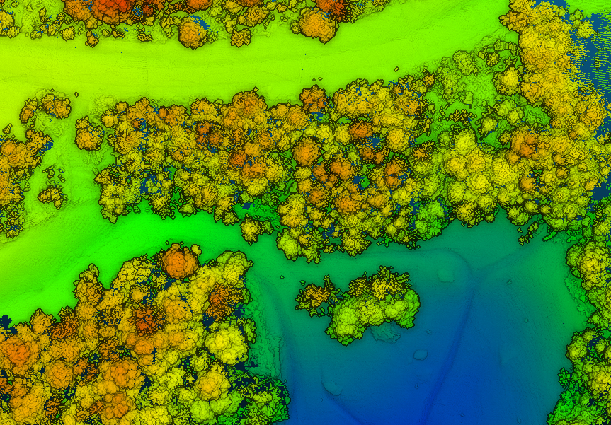
Summer is here, and with it comes the challenge of creating accurate topographic maps under tree canopies. The adoption of drone-based, 3D light detection and ranging — or lidar — is emerging as the go-to sensing technique to meet this challenge consistently, safely and cost effectively.
Designed specifically for use on small drones, the RTL-400 from RedTail Lidar Systems was developed with technology licensed from the U.S. Army Research Laboratory (ARL). The RTL-400 is designed to provide high-resolution 3D images of objects on the ground, flying at an altitude of up to 400 feet.
The RedTail team recently partnered with the West Virginia Department of Environmental Protection (WVDEP) Division of Mining and Reclamation to demonstrate the RTL-400’s ability to generate an accurate digital terrain model (DTM) under “leaf on” conditions. This can be challenging, because pulsed laser light needs to reach the ground to generate laser light ground returns.
One mission of the WVDEP Division of Mining and Reclamation is to assure compliance with the West Virginia Surface Mining and Reclamation Act and other applicable state laws. This task requires ongoing monitoring, mapping and assessment of sites across the state that are actively being reclaimed.
Originally utilizing photogrammetry to generate point clouds, the WVDEP was unable to create the accurate, under-canopy DTMs that they desired. Looking for an alternate method, they began to consider lidar.
The RedTail lidar team met with WVDEP representatives at a mine reclamation site in a remote area of south-central West Virginia. The terrain was a mixture of rolling hillside covered with grasses, brush and tree stands.
The RTL-400 demonstration flight mapped approximately 20 acres of the reclamation site in 12 minutes, flying at an altitude of 196 feet and a speed of 18 mph.
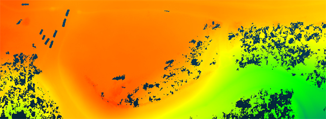
Once the data was collected, a digital terrain model (DTM) was created, revealing the RTL-400’s ability to generate the high-resolution, high-density point cloud needed to accurately map the terrain beneath the tree. 
Digital terrain model (DTM) generated from RTL-400 point cloud. (Image: RedTail)
The RTL-400 delivered all three key elements needed to provide DTMs in foliated areas:
a small beam divergence of 0.5 milliradians (.03 degrees) with a spot size of just 2 inches diameter at the canopy cover
the ability to analyze up to five returns from every transmitted pulse so that returns from the ground can be received and processed
a pulse density of 800 pulses in every square meter of the canopy (for the WVDEP flight). 
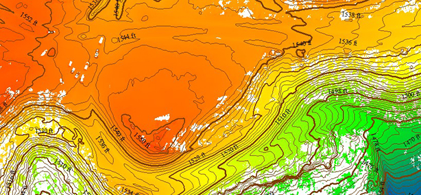
RTL-400 generated digital terrain model (DTM) overlaid with contour map. (Image: RedTail)
RedTail Lidar Systems is a division of 4D Tech Solutions Inc., a company focused on providing innovative technology-based solutions to address government and commercial customer needs. RedTail’s in-house technical expertise — coupled with a full suite of software and hardware design and manufacturing tools — allows the company to develop custom lidar solutions for manned and unmanned vehicle applications.