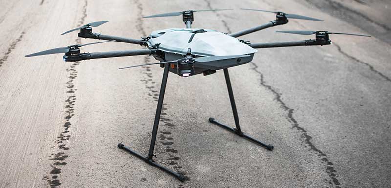
Fortem Technologies has completed the first phase of the U.S. Department of Transportation’s Unmanned Aircraft Systems Integration Pilot Program (UAS IPP) in North Carolina.
As part of the program, Fortem is conducting tests to monitor the airspace around WakeMed Hospital in Raleigh, tracking manned flights alongside the UPS Delivery Corridor, and delivering medical test samples via unmanned drones. Fortem has been using its TrueView radar and SkyDome software system to ensure UAS operations and drone deliveries do not interfere with medical helicopters flying in and out of the area, as well as alert drone operators of any potential non-cooperative aircraft in the vicinity.
According to the company, it was able to accurately and consistently track incoming medical helicopter traffic, providing real-time alerts to Airmap, an unmanned service supplier.
“By monitoring the airspace and creating a service that ensures the safe use of unmanned air vehicles, we will expand from these initial drone deliveries to greater geographical reach and more sophisticated roles for unmanned drones,” said Adam Robertson, CTO of Fortem Technologies. “With Fortem’s ability to offer real time data and analysis of airborne threats, we can start to see additional support for things like search and rescue operations, first responders, and increased shipments of critical supplies to remote locations. None of this can happen without the trust that our systems are effective and safe.”
The North Carolina Department of Transportation (NCDOT) Division of Aviation partners, including WakeMed Hospital, are testing drone operations that will soon go beyond a pilot’s visual line of sight to provide efficient and safe drone operations with the ultimate goal of helping to improve healthcare access for all North Carolinians.
“Ensuring the safety of manned aviation is paramount for unmanned flight operations, yet successful coordination of the two is not an easy task,” said Basil Yap, UAS program manager at NCDOT. “The phase one testing has shown promising results and we are hopeful the phase two operations will provide the information we need to receive a beyond-visual-line-of-sight waiver from the Federal Aviation Administration.”
Fortem will continue to provide situational awareness and secure the airspace into the next phase of the program, the company said. NCDOT, as part of the USDOT UAS IPP, will continue to support its partners’ operations at WakeMed throughout the year until the program’s conclusion in October.
Through the Notice of Funding Opportunity, DOT intends to fund one UTC in each of the following specific topic areas:
Highly automated transportation systems research
Communications technology and e-commerce effects on travel demand
Implications of accessible automated vehicles and mobility services for people with disabilities
Strategic implications of changing public transportation travel trends.
Only U.S. non-profit institutions of higher education are eligible to apply or to be members of a proposed UTC consortium. Non-profit institutions of higher education may include qualifying two-year institutions.
“Our University Transportation Centers are not only the seeds of our future transportation system, they serve as living labs, bringing research to reality. Four new UTCs will address a variety of important 21st century transportation topics,” said Deputy Assistant Secretary Diana Furchtgott-Roth.
Thee Tier 1 UTCs will support research needs that DOT has identified under two of the FAST Act research priorities (49 U.S.C. § 6503(c)(1)): “Promoting Safety” and “Improving Mobility of People and Goods.”
The Notice of Funding Opportunity (NOFO) is available now. For more information on the UTC program, contact Nancy Wilochka, (202) 366-5128.
The U.S. Department of Transportation on Wednesday released updated guidelines for autonomous vehicles.
“Ensuring American Leadership in Automated Vehicle Technologies: Automated Vehicles 4.0” (AV 4.0) was announced by U.S. Transportation Secretary Elaine L. Chao in a keynote speech at CES 2020 in Las Vegas.
AV 4.0 unifies efforts in automated vehicles across 38 federal departments, independent agencies, commissions and executive offices, providing high-level guidance to state and local governments, innovators and stakeholders on the U.S. government’s approach toward autonomous vehicles.
“AV 4.0 will ensure American leadership in AV technology development and integration by providing unified guidance for the first time across the federal government for innovators and stakeholders,” Chao said.
AV 4.0 establishes federal principles for the development and integration of automated vehicles, consisting of three core focus areas: prioritize safety and security, promote innovation, and ensure a consistent regulatory approach.
It also outlines ongoing administration efforts supporting autonomous vehicle technology growth and leadership, as well as opportunities for collaboration including federal investments in the sector and resources for innovators, researchers and the public.
“AV 4.0 brings all of the important work happening on automated vehicle technologies across the federal government under one unified approach. The federal principles released today help foster an environment for innovators to advance safe AV technologies, and put the U.S. in a position of continued leadership in the future of transportation,” said U.S. Chief Technology Officer Michael Kratsios.
The USDOT is preparing for emerging technologies by engaging with new technologies to address legitimate public concerns about safety, security and privacy without hampering innovation, the department said in a press release.
With the release of “Automated Driving Systems 2.0: A Vision for Safety” (ADS 2.0) in September 2017, the USDOT provided voluntary guidance to industry, as well as technical assistance and best practices to states, offering a path forward for the safe testing and integration of Automated Driving Systems.
In October 2018, “Preparing for the Future of Transportation: Automated Vehicles 3.0” (AV 3.0) introduced guiding principles for autonomous vehicle innovation for all surface transportation modes, and described the USDOT’s strategy to address existing barriers to potential safety benefits and progress.
“AV 4.0 builds on these efforts by presenting a unifying posture to inform collaborative efforts in automated vehicles for all stakeholders and outlines past and current federal government efforts to ensure the United States leads the world in AV technology development and integration while prioritizing safety, security, and privacy and safeguarding the freedoms enjoyed by Americans,” the press release stated.
AV 4.0 will be published in the Federal Register for public review and comment. More information on the USDOT’s work on automated vehicles can be found at https://www.transportation.gov/av/4.
The U.S. Department of Transportation “…is seeking the best solutions to ensure that America has a combination of PNT [positioning, navigation and timing] systems which, when used together, will be difficult to disrupt” according to remarks made at a recently concluded conference.
Diana Furchtgott-Roth
Diana Furchtgott-Roth is the department’s Deputy Assistant Secretary for Research and Technology. She made the comments during a keynote address at the Royal Institute of Navigation’s annual conference in Edinburgh mid-November.
Trained as an economist, Furchtgott-Roth noted that Edinburgh was the home of Adam Smith who in the 1700s referred to the efficiency of free markets as an “invisible hand” guiding economies. She regularly referred to GPS as “the invisible hand” guiding individuals, transportation, and technologies across the globe.
Citing GPS as a “one of the great and heroic systems of our times,” she also acknowledged wide and generally unconscious reliance on GPS signals, and its vulnerabilities. “A lot of the work in research and technology at the Transportation Department…assumes the existence of GPS. It assumes that GPS will continue to work, sight unseen, without interference.”
A dedicated GPS-only receiver “sounds as outdated as a pager.”
While PNT is essential now, she said, it will be even more important in the future as it becomes essential for even more safety applications.
“Public confidence in these will be critical. People will not be comfortable getting into an automated vehicle or with platooning driverless trucks heading down the highway if they think that their invisible hand is not reliable and that their GPS might be spoofed.”
As part of this, development and adoption of a wide variety of space-based, terrestrial, and self-contained navigation sensors must be deployed and widely adopted. A dedicated GPS-only receiver, she said, “sounds as outdated as a pager.”
She also echoed the theme of protecting frequencies, toughening receivers, and augmenting GPS signals as a way of achieving greater PNT resilience.
The department let a contract in November for demonstration of 11 technologies that could serve as a GPS augmentation/backup system. Furchtgott-Roth said, “This effort will inform implementation of a system that by law is required to be terrestrial, wireless, have wide area coverage, be difficult to disrupt, and be capable of expansion to provide positioning and navigation services.”
Departing from her prepared script, she added, “The Department of Transportation hopes to come to a decision by next May. Then we will get together with the Defense Department and the Department of Homeland Security and chose a technology or combination of technologies… And then we hope that our Congress will allocate funds to purchase this equipment. Our top priorities are national and economic security. We cannot have GPS be a single point of failure for transport and other critical infrastructure.”
The United States published its National PNT Architecture Study in 2008 citing the need for an integrated and resilient approach. Despite its call for use of multiple phenomenologies and an implementation plan signed several years later little has been done as of yet now.
Furchtgott-Roth’s comments came roughly a month after a Chinese representative to a Stanford symposium that here nation was developing a national “comprehensive PNT” after the fashion of what was called for in the U.S.’s 2008 study.
The U.S. Department of Transportation is preparing for a GPS backup and complementary positioning, navigation and timing demonstration for the Department of Defense at the Joint Base Cape Cod, Massachusetts.
Demonstration for testing is expected to begin in the spring of 2020, and DOT is seeking contractors to make Building #2410 at the base functional so that the demonstrations can be held there.
Diana Furchtgott-Roth, deputy assistant secretary of Transportation for Research and Technology, is leading the project. Working through the Volpe National Transportation Systems Center, Furchtgott-Roth’s goal is to demonstrate as many of the technologies as possible and conclude the effort by March of next year.
The GPS Directorate has released updates to the below Interface Control Documents (ICD). ICDs are the formal means of establishing, defining, and controlling interfaces and for documenting detailed interface design definitions for the GPS program.
Updated Documents
IS-GPS-200: Navstar GPS Space Segment/Navigation User Interfaces
IS-GPS-705: Navstar GPS Space Segment/User Segment L5 Interface
IS-GPS-800: Navstar GPS Space Segment/User Segment L1C Interface
ICD-GPS-240: Navstar GPS Control Segment to User Support Community Interface
ICD-GPS-870: Navstar Next Generation GPS Control Segment (OCX) to User Support Community Interface
Download or view the updated ICDs at GPS.gov or NAVCEN.
59th CGSIC Meeting Set for September
The U.S. Department of Transportation (DOT) and the Coast Guard Navigation Center (NAVCEN) have announced plans for the 59th meeting of the Civil GPS Service Interface Committee (CGSIC).
The meeting will take place Sept. 16-17 at the Hyatt Regency Miami in Miami, Florida, in conjunction with the Institute of Navigation’s ION GNSS+ 2019 conference.
CGSIC meetings are free and open to the public. Subcommittees of the CGSIC for Timing, International Information, and Survey, Mapping, and Geosciences will hold meetings Sept. 16, and a summary of these meetings will be presented to the CGSIC plenary session Sept. 17.
The meeting will include important briefings on the status of ongoing GPS programs and a keynote address by Diana Furchtgott-Roth, deputy assistant secretary, Office of the Assistant Secretary for Research and Technology, U.S. Department of Transportation.
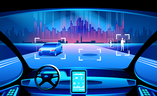
The U.S. Department of Transportation (USDOT) convened leaders from state departments of transportation, stakeholders in academia, and representatives from the auto industry in Washington, D.C., to discuss the importance of preserving the 5.9 GHz spectrum for transportation safety.
The 5.9 GHz band supports vehicle-to-everything (V2X), a wireless technology that enables data exchanges between a vehicle and its surroundings. Starting with advanced technology development and demonstrations about 20 years ago, America has deployed 54 operational V2X projects, improving safety today, with more in the pipeline.
Vehicle manufacturers are planning to equip new cars with the technology. This next generation of intelligent transportation communications promises to improve safety for drivers and for vulnerable roadway users, such as pedestrians, bicyclists, disabled persons and transit users.
The National Highway Traffic Safety Administration (NHTSA) estimates that full adoption of just two V2X safety applications would prevent about half a million crashes and save approximately 1,000 lives a year. As more safety applications are developed for vehicles, more lives could be saved.
V2X will also support an efficient, safe, and smooth transportation system, with vehicles communicating with traffic lights to improve the flow of traffic. V2X applications such as dynamic traffic signal control and prioritization have the potential to reduce travel times by up to 27% and reduce fuel emissions.
Link to video of CV2X demonstration in Hawaii in June. (Photo: USDOT)
The U.S. Department of Transportation’s most recent document preparing for the future of self-driving cars almost entirely ignores positioning, navigation and timing (PNT) needs, according to the Resilient Navigation and Timing (RNT) Foundation. And when it does address GPS, it gets things wrong. A Dec. 3 deadline looms for interested parties to file their comments with DOT.
The comment period is open until December 3. Interested parties can make their own comments and read those already submitted at the website for Docket DOT-OST-2018-0149.
The cited comment from the RNT Foundation states that, while most self-driving cars are being designed to navigate without external inputs, GPS/GNSS will still be required to initialize location information for vehicle cold startups. Also, most vehicles will reference GPS/GNSS when communicating their positions to other vehicles and traffic control systems.
Much of the benefit of automated vehicles will come from their participation in Intelligent Transportations Systems. This means wireless networks. The RNT Foundation also urges the department to consider these networks’ critical dependence on GPS timing synchronization in their plans going forward.
(Image: Pavel Vinnik/Shutterstock.com)
The Secretary of Transportation has had a mandate to provide a backup capability for GPS since 2004 that has not been acted upon. The RNT Foundation comments observe that doing so could greatly mitigate all of the concerns mentioned.
Dana Goward is president of the Resilient Navigation and Timing Foundation, based in Washington D.C.
Brig. Gen. John E. Shaw is Director of Strategic Plans, Programs, Requirements and Analysis, Headquarters Air Force Space Command, Peterson Air Force Base, Colorado. (Photo: USAF)
The U.S. Department of Transportation and the Coast Guard Navigation Center are preparing for the 58th annual Civil GPS Service Interface Committee (CGSIC) meeting.
The meeting will be conducted Sept. 24-25 at the Hyatt Regency Miami in Miami, Florida, in conjunction with the Institute of Navigation’s ION GNSS+ 2018 conference.
CGSIC meetings are free and open to the public.
Subcommittees of the CGSIC for Timing, International Information, and Survey, Mapping, and Geosciences will hold meetings Sept. 24, and a summary of these meetings will be presented to the CGSIC plenary session Sept. 25.
The meeting includes important briefings on the status of ongoing GPS programs and a keynote address by Brig. Gen. John Shaw, director of strategic plans, programs, requirements and analysis for the Air Force Space Command.
The CGSIC agenda in development can be found at gps.gov.
NXP Semiconductors N.V. has announced the next phase in its Smart City collaboration with Columbus, Ohio, the winner of the 2016 U.S. Department of Transportation’s $40 million Smart City Challenge.
NXP will contribute key technologies for smart and safe mobility to the Smart Columbus Experience Center.
Smart Center. On June 30, the City of Columbus celebrated the opening of its Smart Columbus Experience Center. The center allows visitors to see how new mobility options, such as connected, autonomous, shared and electric vehicles, will help make Columbus a more connected community.
Hands-on educational experiences and technology demonstrations aim to show visitors how technology and innovation in transportation can grow the local economy and create ladders of opportunity for central Ohio residents.
Visitors to the Smart Columbus Experience Center will learn how Vehicle to Everything (V2X) Technology allows cars to communicate with each other as well as with intelligent traffic infrastructure to keep mobility safe and efficient. (Image: NXP USA)
Cohda Wireless. As part of the Smart Columbus Experience Center initiative, NXP and Cohda Wireless will deploy a connected vehicle environment through the center’s electric vehicle test drive area so drivers can experience this future technology in person.
NXP has also donated an electric motorcycle with an accompanying drone that alerts the driver to dangers or delays ahead.
Key smart city technologies
As part of its commitment to Columbus, NXP will continue to contribute key mobility technologies to the Smart Columbus Experience Center, including:
NXP’s RoadLINK V2X technology allows cars to communicate with each other as well as with intelligent traffic infrastructures. The IEEE802.11p Dedicated Short Range Communications (DSRC) standard allows cars to securely connect to each other as well as to infrastructure. DSRC technology is the only ADAS sensor that can look around the corner and offers lowest latency in the communication.
Smart Card IC technology that enhances transportation for all citizens by supporting secure and convenient public transportation ticketing and payment systems, including contactless transit fare solutions.
Highly secure NXP Radio Frequency Identification (RFID) solutions designed to promote public safety and convenience. Smart City applications for this NXP technology include vehicle window stickers that enhance driver convenience and reduce municipal costs by eliminating the need for stop-and-pay stations in public parking spaces.
NXP eBike and Drone demo at the new Smart Columbus Experience Center shows how drones could send real-time video of a traffic incident to a city emergency vehicle. (Image: NXP USA)
Concept of Operations released
Smart Columbus, the smart city initiative from the City of Columbus, in July released the Concept of Operations for its Connected Vehicle Environment (CVE) pilot.
The Concept of Operations outlines in detail how the CVE pilot will be implemented over the next two years. The pilot will involve:
113 road side units (RSUs) that will be installed at intersections with stoplights
up to 1,800 on-board units (OBUs) that will be installed on participating private, emergency transit and freight vehicles, and
12 vehicle-to-vehicle or vehicle-to-infrastructure applications that will be deployed, according to the document.
Goals of the CVE pilot include improvements of:
vehicle operator safety
intersection safety
school zone safety
reliability of transit vehicle schedule adherence
emergency vehicle response times
traffic management capabilities.
Smart city demonstrations. Visitors to the Smart Columbus Experience Center can try out electric automobiles. A fleet of six electric vehicles will be on display and is available for test drives through a connected vehicle environment provided by NXP and Cohda Wireless.
Vehicles on display or available for test drives include:
a BMW i3 provided by BMW
a Chevrolet Bolt provided by Dave Gill Chevrolet
a Honda Clarity provided by Honda
a Mercedes-Benz GLE 55e provided by Daimler
a Nissan LEAF provided by Nissan North America
a Toyota Prius Prime provided by Toyota.
An electric motorcycle provided by NXP and a Ford Ojo electric scooter are also on display.
Eight years on, and the money generated by a hedge fund still seeks to destabilize the Global Positioning System and the billions of people who benefit from it, whether they create it, administer it, sell it or use it.
That accounts for just about everybody touched by telecommunications and the industrial network, including the brave individuals serving in the military.
For rewards to the few, the U.S. government is lobbied to levy hardship on the many. In the service of that lobbying, the truth is manipulated to suit the ends. Sound familiar?
See this article for facts and findings of years of detailed study of this matter, recounted in the recently released Department of Transportation’s Adjacent Band Compatibility (ABC) Assessment Final Report. That it appears almost a year after all the research and nearly all the analysis was completed suggests that powerful forces are at work, perhaps warring with each other, within the government. Let us hope that the guys and gals with the good hats on can prevail.
The matter now rests with the Federal Communications Commission, an appointed panel not subject to the electorate nor to Congress, whose decisions sometimes carry a scent of influence from hidden quarters. Note particularly the recent ruling against net neutrality, which most agree runs counter to public interest and correlative with private corporate interests.
As our news story states, the ability to use the mobile satellite services (MSS) band for terrestrial services is “limited.” The DOT ABC Assessment, using the 1-dB Interference Protection Criterion of a 1-dB drop in carrier-to-noise density ratio that’s accepted by everybody — specifically, every engineer — on Earth except Ligado Networks, demonstrates conclusively there is no chance the company could actually deploy a viable commercial terrestrial service in the MSS spectrum without disrupting or degrading vital GPS and GNSS services.
The U.S. government and the GPS industry have both expended far too much money and time trying to accommodate a force-fit of a non-compatible use into the bands adjacent to the radionavigation satellite service band, to the benefit of one commercial company’s bottom line.
It’s high time for this nonsense to stop. Nobody, least of all the government and the GNSS industry, owes Ligado anything.
The culmination of several years of test and analysis conducted by the U.S. Department of Transportation, the assessment will play a key role in the Federal Communications Commission’s upcoming decision on a proposal from Ligado Networks.
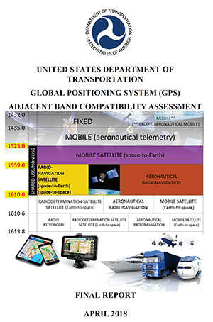
The long-awaited Final Report for the U.S. Department of Transportation’s Adjacent Band Compatibility (ABC) Assessment was released on April 26.
The report is the culmination of several years of test and analysis conducted by the DOT, with input and assistance from the public and federal agency stakeholders. Though not explicitly motivated by it, the assessment appears to be responsive to the Positioning, Navigation, and Timing (PNT) Executive Committee’s (EXCOM’s) Jan. 13, 2012, memorandum to the National Telecommunications and Information Administration (NTIA) that sought to develop metrics to inform commercial non-space proposals for use of frequency bands adjacent to those used by GPS, so that existing and evolving space-based PNT services “vital to economic, public safety, scientific and national security needs” were not affected by implementing such proposals.
The assessment will likely play a key role in the Federal Communications Commission’s upcoming decision on a proposal from Ligado Networks to add an extensive complex of powerful ground transmitters to its system, broadcasting on frequencies allocated for satellites.
Open and Transparent. Two key attributes of the ABC assessment were that it was conducted openly and transparently, with numerous public workshops announced via the Federal Register, and it was agnostic to any particular proposal for use of bands adjacent to GPS/GNSS services. The approach chosen by DOT in performing its assessment was to develop maximum tolerable effective isotropic radiated power (EIRP) levels that could be transmitted at differing frequency offsets from the GPS L1 center frequency.
The term “adjacent” in this regard is a bit of a misnomer in that the assessment range extended to 100 MHz on either side of the GPS L1 center frequency of 1575.42 MHz. This approach was recently validated by the National PNT Systems Engineering Forum (NPEF), which found the ABC assessment was the only one of five test and analysis efforts conducted since 2011 on adjacent-band terrestrial operations that met all six of the test criteria recommended by the experts serving on the National PNT Advisory Board. The NPEF analysis is available here.
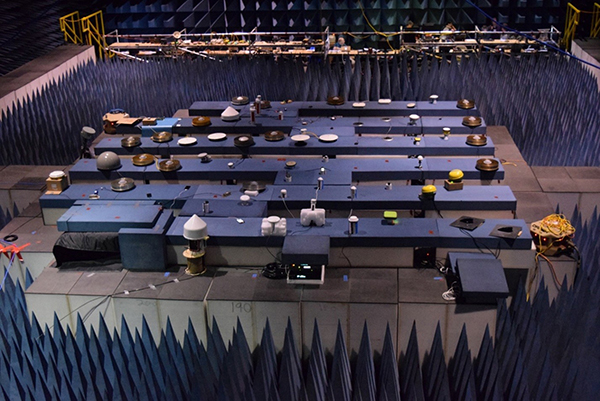
Measurements on 80 civil GNSS and GPS receivers were performed at White Sands Missile Range (WSMR) in New Mexico. The Air Force conducted a prior week of testing on military GPS receivers at WSMR, and while the results of that testing are classified, an Air Force briefing at the November 2017 PNT Advisory Board meeting indicated the military receiver test results supported the conclusions drawn by the DOT ABC assessment. Certified aviation GPS/GNSS receivers were analyzed by RTCA Inc. and are being analyzed by the FAA in terms of determining power levels in adjacent bands that don’t exceed FAA Technical Standard Orders. However, the overall ABC assessment indicates that certified aviation receivers are not the limiting case for tolerable interference from adjacent-band services to GPS and GNSS receivers.
Test Procedures
Compatibility assessment for the civil receivers consisted of conducting the initial measurements at WSMR for six categories of receivers: aviation (non-certified), cellular, general location/navigation, high-precision, timing, and space-based receivers. These were evaluated to determine what DOT called Interference Tolerance Masks (ITMs) for each category of receiver and each receiver tested. The ITMs define the maximum aggregate interfering power that can be tolerated by a given GPS or GNSS receiver. The ITMs are based on the internationally accepted Interference Protection Criterion (IPC) of a 1-dB drop-in carrier-to-noise density ratio (C/NO) for the receiver, or, equivalently, an interference density-to-noise ratio (IO/NO) of –6 dB. This 1 dB IPC standard, which NTIA directed to be used in the NPEF evaluation of the original LightSquared (now Ligado) adjacent-band proposal in late 2011, is explained in great detail in a white paper the Air Force made publicly available in 2017.
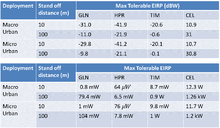
The assessment then developed, with input from the public at several workshops convened by the DOT, use cases to determine how close a receiver for a particular GPS or GNSS application might be to a base station or handset of a commercial terrestrial service in an adjacent band. Proximity distances of 10 and 100 meters were selected from these use cases, and maximum tolerable transmit EIRP levels for a given frequency offset were determined; see Figure 1. The high-precision receivers (HPRs) were the most susceptible to interference from terrestrial operations in the adjacent bands.
Figure 1. Maximum tolerable power level for GPS/GNSS receivers at 1530 MHz. (Table: DOT)
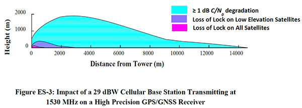
One thing that seems clear is that, with tolerable transmit power levels in the milliwatt and microwatt range, the potential to use the bands near GPS frequencies for commercial terrestrial wireless services may be limited. Illustrating that point further, the assessment shows that, based on the assumptions in the study, HPRs can be affected at distances beyond 14 kilometers (see Figure 2), and that loss of lock for low-elevation satellites can occur at distances of up to 3 kilometers from a base station providing terrestrial services using characteristics adopted internationally in the International Telecommunication Union (ITU) study groups.
Figure 2. Impact of a 29-dBW cellular base station transmitting at 1530 MHz on a high-precision GPS/GNSS receiver. (Chart: DOT)
Moreover, the assessment determined that the potential interference to other GNSS systems may be more problematic, noting that “the levels that protect all GNSS signals can be as much as 15 dB lower than those needed to protect L1 C/A signals from base station emissions with an average difference of 3.5 dB across all frequencies and five categories considered.”
Galileo’s Role. Since 2013, according to a Public Notice from the FCC, the European Commission has sought a waiver of FCC rules that require licensing of receivers operating with foreign satellites so that Galileo service can be provided in the United States. The FCC has yet to act on this waiver request, which was issued in a January 2017 Public Notice, despite overwhelming public support and a positive recommendation from the Executive Branch in 2015.
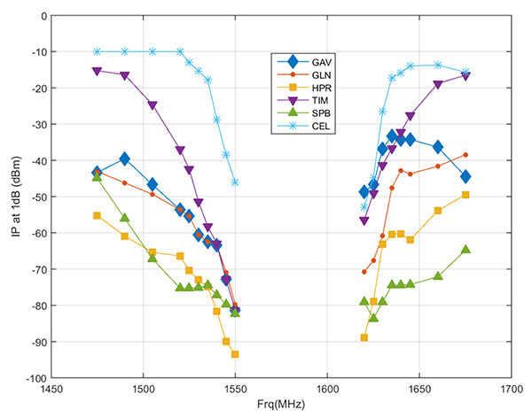
Figure 3. Bounding masks for each category corresponding to the 10 MHz LTE interference signal and L1 C/A GPS signal: general aviation, general location and navigation, high precision, timing, space-based, cellular. (Graph: DOT)
Conclusions
It is well known that all receivers take in some power from signals transmitted in nearby frequency bands. Considering this fact, the ABC assessment is relatively unique in that it examines the overall spectral environment in which GPS/GNSS operations can be affected rather than just the band allocated to the Radionavigation-Satellite Service (RNSS, the broad radiocommunication service defined in the ITU and in domestic rules under which GPS and other GNSS systems operate) between 1559–1610 MHz. That the overall environment should be considered is an important aspect of any discussion of protecting GPS and other GNSS services given the U.S. National Space Policy that was signed into effect June 28, 2010, that directs the U.S. government to “take necessary measures to sustain the radiofrequency environment in which critical U.S. space systems operate.” This policy is still in effect, and it would be difficult to argue that GPS is not a critical U.S. space system.
Recently, the reconstituted National Space Council adopted four recommendations, one of which related to spectrum used for satellite services and said that NTIA should coordinate with the FCC to ensure “the protection and stewardship of radio frequency spectrum necessary for commercial space activities.” Stewardship that is consistent with National Space Policy would include sustaining the RF environment for GPS.
As the PNT EXCOM has made clear, GPS is “vital to economic, public safety, scientific, and national security needs” of the U.S. Moreover, economic analysis presented to the PNT Advisory Board in 2015 estimated the economic benefit to the nation of GPS services at over 68 billion dollars annually. With the release of the ABC assessment, definitive information is now available to inform decisions on use of frequencies near those used to provide space-based PNT services so these critical services are not disrupted or degraded.