SeapPort-e, the U.S. Navy’s electronic platform for acquiring support services, has awarded Esri a defense contract for its geographic information system (GIS) technology services. SeaPort-e provides a standardized, efficient means of soliciting services and support from businesses small and large.
This indefinite delivery/indefinite quantity (IDIQ) contract simplifies the acquisition process for the federal government by facilitating multiple task orders for customers without forcing companies to recompete. The SeaPort-e platform acquires support services in 22 functional areas and conducts rolling admissions to encourage small business participation. Nearly 85 percent of SeaPort-e’s contract holders include small businesses.
Esri collaborated with nine small business team members — Aerial Information Systems; APEX Expert Solutions LLC; Geographic Information Services, Inc.; Lynker Technologies, LLC; Metron Incorporated; Orca Maritime, Inc.; Punctuate Systems, Inc.; T3W Business Solutions; and VSolvit LLC — to participate in the contract. Each team member offers expertise that is complementary to Esri’s support program.
Esri is committed to supporting small businesses in their objectives to grow their federal footprint and, earlier this year, launched Federal Small Business Specialty, a partner program to enable that mission.
Partnering with Esri offers many opportunities for small businesses to provide consulting, implementation, and solutions to meet geospatial requirements and provide ArcGIS software related services, Esri said. SeaPort-e will allow Esri to leverage small business partners’ capabilities and also support their growth.
“Our business model is to team up with Esri partners to serve U.S. Navy customers,” said Curt Hammill, Esri navy account executive. “Our goal is to make them both successful. SeaPort-e gives us a new vehicle to do that.”
Esri joins other awardees in providing support to the U.S. Navy across areas such as research and development, systems engineering, modeling and simulation, software engineering, and quality assurance.
Insitu has been awarded a US$71 million follow-on contract to produce six RQ-21A Blackjack unmanned aerial systems (UAS), with options for two more, from U.S. Navy Naval Air Systems Command (NAVAIR).
The RQ-21A is recovered with the flight recovery apparatus cable aboard the San Antonio-class amphibious transport dock USS Mesa Verde after its first flight at sea. The tests were held in the Gulf of Mexico on Feb. 10, 2013.
The RQ-21A Blackjack has significantly larger payload mass, volume and power than other small UAS currently being used in theater, according to Insitu, a subsidiary of The Boeing Company. The system includes electro-optic and mid-wave infrared sensors with a laser rangefinder and infrared marker.
The Low Rate Initial Production (LRIP) Lot V contract also includes an option year for nine Full Rate Production (FRP) systems. The FRP decision review is expected this fall.
“This contract award paves the road for Blackjack’s continued and future fleet integration,” said Col. Eldon Metzger, program manager for the Navy and Marine Corps Small Tactical Unmanned Aircraft Systems Program Office. “It is at the tactical edge for Marine and Navy units and the foundation to support future system enhancements.”
“Blackjack delivers an organic intelligence, surveillance and reconnaissance UAS that is runway-independent and founded on an open architecture that allows for implementation of innovative payloads to meet critical operational demands,” said Ryan M. Hartman, Insitu’s president and CEO. “We are proud to provide the sailors and marines with reliable, capable systems that support their warfighting needs.”
NAVAIR awarded the STUAS Engineering Manufacturing Development contract to Insitu in 2010 to begin the development of RQ-21A Blackjack, a variant of the company’s Integrator unmanned system. The program achieved Milestone C in 2013, delivered the first LRIP system in 2014, and achieved initial operational capability in January.
Virtually all unmanned systems, from drones to autonomous vehicles, use GPS location technology and advanced mapping. As systems evolve, and enemy threats become more sophisticated, new requirements are emerging. The U.S. military is out in front of this trend, developing unmanned autonomous systems at an even faster pace, with more ambitious goals, than the civilian market. This is borne out by several recent tests and announcements, all profiled individually at env-gpsworld-integration.kinsta.cloud. This month’s column rounds up their essential details for a skyview of the burgeoning field.
Publisher’s note: Defense PNT columnist Don Jewell will return next month.
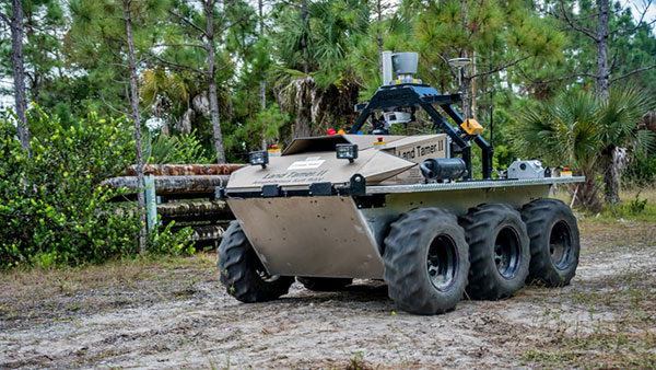
An unmanned Black Hawk delivers an autonomous ground vehicle to a remote site in a demonstration for the U.S. Army of a joint robotic air-ground mission.
Carnegie Mellon University and Sikorsky Aircraft used an autonomous helicopter and an autonomous ground vehicle to demonstrate that ground and air robots can perform complex, cooperative missions. In an October 2015 demo, an unmanned Black Hawk helicopter picked up an unmanned ground vehicle (UGV), flew a 12-mile route, delivered the UGV to a ground location and released it.
The drop-zone collaboration promises to keep warfighters out of harm’s way. For example, this type of robotic mission could avoid warfighters’ exposure to hazardous conditions, such as chemically or radiologically contaminated areas.
The Black Hawk was equipped for autonomous operation by Sikorsky, a Lockheed Martin Co. It delivered a Land Tamer autonomous unmanned ground vehicle from Carnegie Mellon’s National Robotics Engineering Center to a remote site, where the vehicle performed environmental monitoring for potential contamination.
“We were able to demonstrate a new technological capability that combines the strengths of air and ground vehicles,” said Jeremy Searock, NREC technical project manager. “The helicopter provides long-range capability and access to remote areas, while the ground vehicle has long endurance and high-precision sensing.”
Once the helicopter lowered the vehicle to the ground, the Land Tamer drove itself off its transport platform to commence its leg of the mission. The vehicle, equipped with sensors for detecting chemical, biological, radiological or nuclear contamination, then found and surveyed several potentially contaminated sites, autonomously traversing six miles in the process. When the vehicle sensors detected potential contamination, operators were able to switch the vehicle from autonomous operation into a tele-operated mode for a more detailed exploration of the site.
A JPADs pallet lands on target, followed by several others still in the air, during recent testing. (Photo: US Army)
The U.S. Army’s Joint Precision Airdrop System (JPADS) has developed a new capability with a navigation alternative to GPS. In recent tests, JPADS were dropped from planes, and immediately determined their location using optical sensors to compare local terrain with commercial satellite imagery. The new system demonstrated navigation to its intended point, using nothing but imagery to guide it.
JPADS, largely guided by GPS, has already proven its importance in supplying troops with necessary materials and equipment, relying less on vulnerable convoys. However, the new JPADS also works with little knowledge of the aircraft’s location at the drop point.
Dropping critical supplies from the air has allowed the U.S. military to rely less on easily-ambushed truck convoys and helicopter resupply. Exposure to improvised explosive devices (IEDs) and ambushed convoys resulted in more than 3,000 causalities in Afghanistan and Iraq through 2007.
JPADS has proven to be an important tool in the Army’s logistics chain in many scenarios to supply troops with material and equipment in adverse terrain and remote locations when ground lines of communication are not possible or deemed too high a risk.
“This is a huge step forward for aerial resupply,” said Chris Bessette, Draper’s JPADS program manager. “By enabling the system to operate using imagery alone when dropped as high as 25,000 feet above Mean Sea Level and upwards of 20 miles away from the target depending on winds, we can ensure that JPADS is even more versatile so troops receive supplies like fuel, ammunition, food, and water in the safest manner possible.”
In August, U.S. Army Gray Eagle unmanned aircraft took part in manned-unmanned teaming exercises in South Korea, including streaming video and metadata to an AH-64 Apache helicopter while in flight. The MQ-1C Gray Eagle proved its ability to conduct operations in diverse weather condition, according to manufacturer General Atomics Aeronautical Systems (GA-ASI). The Gray Eagle is used by the Army for reconnaissance, surveillance, communications, convoy protection, IED detection and precision weapons delivery.
During the exercise, the Gray Eagle UAS streamed video and metadata via a line-of-sight data link directly to the helicopter from extended distances. The Apache then retransmitted the imagery to a One System Remote Video Terminal (OSRVT), allowing field commanders within the Tactical Operations Center (TOC) to receive both live Gray Eagle streaming video and retransmitted video sent by the Apache. Once the Gray Eagle was airborne, U.S. ground forces passed contact reports and target coordinates to operators in the aircraft’s ground control station. The operators were then able to direct the Gray Eagle’s sensors to positively identify and track the targets.
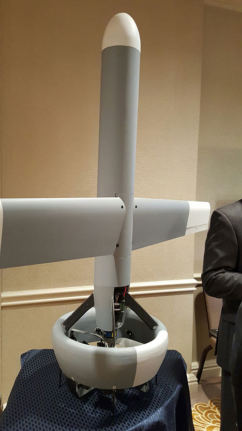
A V-Bat UAV from Martin UAV. Applications include aerial mapping, border patrol, shipboard operations and others.
Worldwide threats will make robotic and autonomous systems’ development important for decades, according to officials speaking at the Unmanned Systems Defense conference late last year.
GPS World’s contributing editor Kevin Dennehy wrote, “Because America has been at war for more than 14 years, unmanned technology has been developing at a rapid rate, perhaps even faster than emerging autonomous commercial systems. The replacement of even manned aircraft has some in the military establishment wary, but others know it’s only a matter of time before most vehicles, surface ships and aircraft are unmanned.”
The Secretary of the Navy said its current manned fighter plane, scheduled to see activity from now until 2037, may be its last to carry an actual human pilot.
The Navy’s Kraken drone munitions delivery system begins its mission underwater,then explodes past the surface to operate in the air. The Air Force also is developing small drones that can be launched and recovered by a larger aircraft after a mission is complete.
An Army initiative called Leader Follower includes rudimentary autonomous convoy operations capability with GPS and base mapping systems, autonomous steering and braking. Army program managers say the program is in staffing, but should be approved in a few months. A full-blown Automated Convoy Operations capability would allow any manned system, including tanks and mobile artillery, to operate autonomously. Last year, the Army and Lockheed Martin successfully demonstrated a driverless line-haul convoy with seven military trucks at speeds up to 40 mph.
Talking about a new generation
Lt. Gen. Michael Williamson, U.S. Army deputy to the assistant secretary of defense for acquisition, said the service is divesting its aging robotics and drone systems, which means future contracts for defense companies. “In 14 years of war, we have rode this equipment pretty hard,” he said. “We believe in modernization, but also looking to buy new systems, which is a new shift in order to gain a competitive advantage over our enemies, who are leveraging unmanned systems.”
The Defense Department recently established the Defense Innovation Unit, based in the San Francisco Bay area, to take advantage of rapid autonomous developments in the Silicon Valley.
Virtually all unmanned systems, from drones to autonomous vehicles, use GPS location technology and advanced mapping. As systems evolve, and enemy threats become more sophisticated, new requirements are emerging.
A surrogate LDUUV is submerged in preparation for a test to demonstrate the capability of the Navy’s Common Control System at the Naval Undersea Warfare Center Keyport in Puget Sound, Washington. (U.S. Navy photo)
In December 2015, the U.S. Navy tested its newly developed Common Control System (CCS) with a submersible unmanned vehicle in underwater missions in Puget Sound, Washington. The CCS successfully demonstrated its capability to provide command and control to a surrogate Large Displacement Unmanned Undersea Vehicle (LDUUV) — an underwater UAV destined for reconnaissance and surveillance missions.
CCS is a software architecture with a common framework, user interface and components that can be integrated on a variety of unmanned systems. It will provide common vehicle management, mission planning and mission management capabilities for the Naval unmanned systems portfolio. Operators used the CCS to transmit pre-planned missions via radio link to the LDUUV’s autonomous controller. In turn, CCS displayed actual vehicle status information to the operators. The vehicle was able to maneuver to the target areas and collect imagery.
“These tests proved that operators could use CCS from a single global operations center to plan, command and monitor UUVs on missions located anywhere in the world,” said Capt. Ralph Lee, who oversees the Navy’s CCS program at Patuxent River, Maryland. “This event also showed us that CCS is adaptable from the UAV (unmanned aerial vehicle) to UUV missions.”
CCS is intended to be compatible across all domains — air, surface, undersea and ground. The Navy initially plans to deploy the CCS on unmanned air vehicles. It will provide common vehicle management, mission planning and mission management capabilities for the Naval unmanned systems portfolio.
A surrogate LDUUV is submerged in preparation for a test to demonstrate the capability of the Navy’s Common Control System at the Naval Undersea Warfare Center Keyport in Puget Sound, Washington. (U.S. Navy photo)
The U.S. Navy tested its newly developed Common Control System (CCS) with a submersible unmanned vehicle during a series of underwater missions at the Naval Undersea Warfare Center Keyport in Puget Sound, Washington.
The CCS successfully demonstrated its capability to provide command and control to a surrogate Large Displacement Unmanned Undersea Vehicle (LDUUV).
CCS is a software architecture with a common framework, user interface and components that can be integrated on a variety of unmanned systems. It will provide common vehicle management, mission planning and mission management capabilities for the Naval unmanned systems portfolio.
During the test events in Dec. 7-11, operators from Submarine Development Squadron 5 Detachment UUV used CCS to plan and execute several surveillance and intelligence preparation missions. The CCS sent pre-planned missions — via radio link — to the LDUUV’s autonomous controller and displayed actual vehicle status information to operators during the test. The vehicle was able to maneuver to the target areas and collect imagery.
“These tests proved that operators could use CCS from a single global operations center to plan, command and monitor UUVs on missions located anywhere in the world,” said Capt. Ralph Lee, who oversees the Navy’s CCS program at Patuxent River, Maryland. “This event also showed us that CCS is adaptable from the UAV (unmanned aerial vehicle) to UUV missions.”
Teams from the Navy’s Strike Planning and Execution and Unmanned Maritime Systems program office (PMA-281), Naval Air Warfare Center Weapons Division, Space and Naval Warfare Systems Command Pacific, John Hopkins and Penn State universities worked together to design, develop and test the software before executing the live demonstration in December.
“We had a really talented group of people working on this project,” said Vern Brown, who supports the CCS Advanced Development team based in China Lake. “It was exciting taking the CCS concept of controlling an undersea vehicle from inception early in the year to a successful in-water demonstration.”
CCS is intended to be compatible across all domains — air, surface, undersea and ground. The Navy initially plans to deploy the CCS on unmanned air vehicles. It will provide common vehicle management, mission planning and mission management capabilities for the Naval unmanned systems portfolio.
“Ultimately, CCS will eliminate redundant efforts, encourage innovation and improve cost control for unmanned systems,” Lee said.
Personnel supporting the Navy’s CCS program review data during a test event in December 2015 at the Naval Undersea Warfare Center Keyport in Puget Sound, Wash. (U.S. Navy photo)
The Navy and Marine Corps’ RQ-21A Blackjack unmanned aircraft system (UAS) received the official green light for operation Jan. 13, marking a major milestone for the program.
The program has achieved Initial Operational Capability (IOC), announced Marine Corps Deputy Commandant for Aviation Lt. Gen. Jon Davis. IOC confirms that the first Marine Unmanned Aerial Vehicle Squadron (VMU) squadron is sufficiently manned, trained and ready to deploy with the RQ-21A system.
“We are ‘go for launch’,” said Col. Eldon Metzger, program manager for the Navy and Marine Corps Small Tactical Unmanned Aircraft Systems Program Office (PMA-263), whose team oversees the Blackjack program. “Achieving IOC designation means the fleet can now deploy using this critical piece of intelligence, surveillance, and reconnaissance architecture to enhance mission success.”
An RQ-21A Blackjack in flight during testing aboard USS Mesa Verde (LPD-19) in 2015. The Marines will deploy for the first time with the unmanned air system this summer. (U.S. Navy photo)
In December 2015, builder Insitu delivered the first system from low-rate initial production (LRIP) lot 3 to VMU-2. The Blackjack system will support of the 22nd Marine Expeditionary Unit (MEU), based in Camp Legeune, North Carolina. The Marines will make their first shipboard deployment with the system this summer.
“The Blackjack team has endured many long hours seeing this program to fruition and I am very proud to lead such a dedicated team of professionals,” Metzger said.
A Blackjack system is comprised of five air vehicles, two ground control systems, and launch and recovery support equipment. At eight feet long and with a wingspan of 16 feet, the air vehicle’s open-architecture configuration is designed to seamlessly integrate sensor payloads, with an endurance of 10-12 hours.
The expeditionary nature of the Blackjack, which does not require a runway for launch and recovery, makes it possible to deploy a multi-intelligence-capable UAS with minimal footprint from ships.
At Unmanned Systems Defense, warfighters had the opportunity to learn about new technologies from government contractors and see demos in the exhibition hall. (PRNewsFoto/AUVSI)
ARLINGTON, Va. — Despite shrinking defense budgets, existing and emerging worldwide threats will make robotic and autonomous systems’ development important for decades, said officials at the Unmanned Systems Defense 2015 conference held here Oct. 27-29.
Because America has been at war for more than 14 years, unmanned technology has been developing at a rapid rate, perhaps even faster than emerging autonomous commercial systems. The replacement of even manned aircraft has some in the military establishment wary, but others know it’s only a matter of time before most vehicles, surface ships and aircraft are unmanned.
Navy Secretary Ray Mabus said that the F-35, which has been controversial because of its cost and capabilities, may be the last manned fighter aircraft.
Mabus acknowledged the rise in autonomous vehicles not only in the military, but in the civilian world. “Our grandchildren may never have to drive a car. I can’t wait for driverless cars,” he said.
The Navy is so high on unmanned systems that it recently named retired Marine Brig. Gen. Frank Kelley as deputy assistant secretary of the Navy for unmanned systems.
Like the other services, the Navy is experimenting with aviation systems that are inexpensive and small. It is developing swarming drones that are designed to overwhelm a target. Mabus said one of the cool drones that the Navy is developing is called Kraken, which operates underwater, then explodes past the surface to operate in the air.
A V-Bat UAV from Martin UAV. Applications include aerial mapping, border patrol, shipboard operations and others.
The Air Force also is developing small drones that can be launched and recovered by a larger aircraft after a mission is complete.
While the meeting was filled with government bureaucrats with the requisite PowerPoint slides detailing how long programs will take, they did say that the services are plowing ahead with autonomous technology that many of their civilian counterparts say are decades away.
Convoy Operations
An Army initiative called Leader Follower includes rudimentary autonomous convoy operations capability with GPS and base mapping systems, autonomous steering and braking. Army program managers say the program is in staffing, but should be approved in a few months.
The follow on to Leader Follower is a full-blown Automated Convoy Operations capability that would allow any manned system, including tanks and mobile artillery, to operate autonomously. Automated Convoy Operations are at least two-to-three years behind the Leader Follower program, Army officials said.
Other Army programs include route clearance systems to defeat underground improvised explosive devices and caches and mine rollers.
With all the new autonomous technology, at least one speaker said the first question should be why an unmanned system is needed at all, given its high cost and long lead times for rollout. “Does the technology enable a [service member] to fight better, or does it just get in the way?” said Lt. Col. Hank Lutz, U.S. Marine Corps joint staff.
Plans to Replace Aging Unmanned Systems
Lt. Gen. Michael Williamson, U.S. Army deputy to the assistant secretary of defense for acquisition, said the service is divesting its aging robotics and drone systems, which means future contracts for defense companies. “In 14 years of war, we have rode this equipment pretty hard,” he said. “We believe in modernization, but also looking to buy new systems, which is a new shift in order to gain a competitive advantage over our enemies, who are leveraging unmanned systems.”
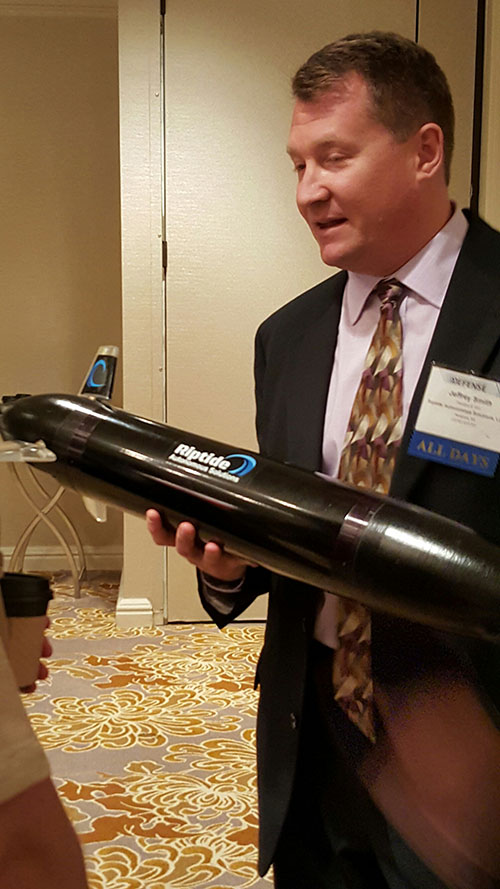
Jeff Smith, president and CEO of Riptide Autonomous Solutions, holds an unmanned undersea vehicle that has GPS sensors and antenna.
The big mantra from the military program managers and senior officials is having an “open architecture” that includes a control segment that works with both manned and unmanned systems. Williamson also echoed the need for standardization, but went further by saying the services should have a list of standards and one place, a facility, to ensure components actually work together.
While the “we want an open architecture” theme was in virtually every speaker’s presentation, one said that there needs to be a balance between the time a product is ready and its interoperability. “The Taliban’s [Program Objective Memorandum] cycle is a lot shorter. Don’t tell me that [your product] is plug and play,” said John Coglianese, U.S. Special Operations Command director, unmanned aerial systems.
DoD Reaches Out to Smaller Businesses, Silicon Valley
Realizing a need to assess new technologies and partner with innovative companies, the Defense Department recently established the Defense Innovation Unit, which is based in the San Francisco Bay area. The office is small with only a few personnel, said George Duchak, who was recently named director.
Duchak acknowledged that some companies suffer from government fatigue in that they see the same presentations over and over. By being out in the Silicon Valley, Duchak’s personnel can be more receptive and listen, rather than talk at companies. His office is made up of people who seek out new technology and vendors, serve as a conduit to local labs and assess companies who want work with the government, among other activities.
“We are kind of in a honeymoon period [with private companies]. It has been interesting finding companies where their patriotism aligns with whether or not they are going to make money,” Duchak said. “Google has been pretty receptive, not so much with Apple.”
Another group, the National Advanced Mobility Consortium, looks to match technology to defense needs for smaller companies looking to do business with the government. “We are trying to show how to engage nontraditional companies,” said Bill Thomasmeyer, National Advanced Mobility Consortium consultant. Thomasmeyer said it’s tough for a small company or individual entrepreneur to go through the complex government procurement cycle. “They are used to Silicon Valley, which has a 90-day cycle. The Federal Acquisition Regulation is 4,000 pages,” he said.
Currently, NAMC has 274 members, a third of which are not defense companies, Thomasmeyer said.
Future of GPS and Location Technology for Unmanned Systems
Virtually all unmanned systems, from drones to autonomous vehicles, use GPS location technology and advanced mapping. As systems evolve, and enemy threats become more sophisticated, new requirements are emerging.
“All of our systems use GPS, but we need to operate in a GPS-denied environment,” said Capt. Aaron Peters, U.S. Navy program manager for expeditionary missions.
Other program managers said what’s also needed is GPS units that feature 3-D navigation for autonomous systems.
In addition to basic positioning and navigation of drones and autonomous vehicles, the Air Force is using location technology to geo-locate damage from shell holes at airfields they use in war zones.
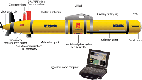
The Remus 600 Unmanned Underwater Vehicle, made by Kongsberg Maritime, a Norwegian company.
The U.S. Navy plans to deploy its first underwater drones from submarines later this year, according to a report by Military.com.
The website quoted Rear Adm. Joseph Tofalo, the Navy’s director of undersea warfare, who said the deployment will include the use of the Remus 600 Unmanned Underwater Vehicles (UUVs) to perform undersea missions around the globe.
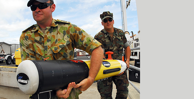
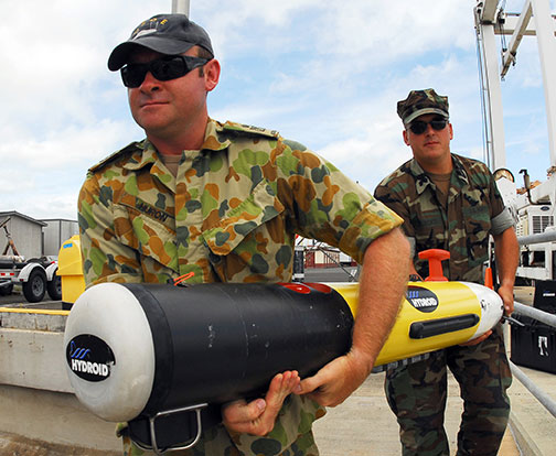
Sailors carry a Remote Environmental Measuring Unit (REMUS) 100. (Credit: U.S. Navy)
“Now you are talking about a submarine CO who can essentially be in two places at the same time — with a UUV out deployed which can do dull, dirty and dangerous type missions. This allows the submarine to be doing something else at the same time,” Tofalo said. “UUVs can help us better meet our combatant command demand signal. Right now, we only meet about two-thirds of our combatant commanders’ demand signals, and having unmanned systems is a huge force multiplier.”
The Remus 600 is a 500-pound, 3.25-meter-long UUV equipped with GPS, as well as dual-frequency side-scanning sonar technology, synthetic aperture sonar, acoustic imaging, and video cameras manufactured by Hyrdoid, a subsidiary of Kongsberg Maritime. The Remus 600 is similar to Bluefin Robotics UUVs, which were used to search for wreckage of missing Malaysia Airlines flight MH370. Other applications include hydrographic surveys, harbor security, and environmental monitoring.
In this video, Explosive Ordnance Disposal Mobile Unit One (EODMU-1) tests the Remus 600 to locate mines using autonomous guidance and advanced sonar.
Lockheed Martin’s paveway II Dual Mode Laser Guided Bomb (DMLGB) was successfully employed in recent U.S. Navy Tactics Development exercises at the Naval Strike and Air Warfare Center in Fallon, Nevada.
During four missions over a two-day period, F/A-18C/D Hornets and F/A-18E/F Super Hornets released 36 GBU-12F/B bombs fitted with recently upgraded paveway II DMLGB guidance kits. The weapons were used in tactically representative engagements against fixed targets and met all mission success criteria, demonstrating the increased operational utility of the enhancements.
By adding the GPS/Inertial Navigation System (INS) guidance to standard laser-guided paveway II weapons, the U.S. Navy and Marine Corps can execute precision-strike missions against stationary and relocatable targets in all weather conditions. The kits can operate in laser mode only, INS/GPS mode only or dual mode to provide pilots with the flexibility to engage various types of targets in a single mission. The most recent paveway II DMLGB upgrade to Block II Operational Flight Program software improves overall weapon performance and effectiveness in all three release modes.
“We worked closely with our U.S. Navy and Marine Corps customers to develop the Block II Operational Flight Program software upgrade to the paveway II DMLGB guidance kits,” said Joe Serra, precision guided systems manager at Lockheed Martin Missiles and Fire Control. “Delivered to the fleet earlier this year, the enhanced fire-and-forget technology of our DMLGB kits provides naval warfighters with a mature and highly maneuverable all-weather direct-attack capability.”
Aircrews from the Naval Strike and Air Warfare Center, along with Air Test and Evaluation Squadron Nine (VX-9) “Vampires” from Naval Air Weapons Station in China Lake, California, participated in the exercises.
“The same company-wide discipline that provides customers with affordable single-mode LGB targeting capability is applied to our current and future dual-mode weapons to provide U.S. and international customers with the most affordable and reliable precision capability,” said Serra.
Lockheed Martin has upgraded more than 7,000 paveway II LGB guidance kits with dual-mode, all-weather capability for the U.S. Navy. Additionally, the company has delivered more than 65,000 LGB kits and over 125,000 Enhanced Laser Guided Training Rounds to the U.S. Navy, Marine Corps, Air Force and international customers. Lockheed Martin is the sole-source developer and provider of the paveway II DMLGB kits to the U.S. Navy and U.S. Marine Corps.
Lockheed Martin Missiles and Fire Control is a 2012 recipient of the U.S. Department of Commerce’s Malcolm Baldrige National Quality Award for performance excellence. The Malcolm Baldrige Award represents the highest honor that can be awarded to American companies for achievement in leadership, strategic planning, customer relations, measurement, analysis, workforce excellence, operations and business results.
Headquartered in Bethesda, Maryland, Lockheed Martin is a global security and aerospace company that employs about 116,000 people worldwide and is principally engaged in the research, design, development, manufacture, integration and sustainment of advanced technology systems, products and services. The Corporation’s net sales for 2012 were $47.2 billion.
In July, the Communications and GPS Navigation Program Office mounted a Small Antenna System on an Aerostar unmanned aircraft, then placed the small UAV in a room lined with signal-absorbent material, where it was subjected to GPS jamming signals. Read more about the tests here.