Esri and the United Nations Statistics Division (UNSD) are working with a number of member states to utilize a data hub that will allow countries to measure, monitor and report on sustainable development goals (SDGs) in a geographic context.
This new hub, called the Federated System for the SDGs, is based on Esri’s ArcGIS platform and will use location intelligence to make it easier for countries to collect, analyze, and share the data required to monitor progress toward the SDGs.
The SDGs are a set of global goals that include such objectives as poverty eradication, access to safe water, clean oceans, eliminating hunger, gender equality, climate action, peace and justice, education and other important areas on the U.N. agenda.
The Federated System explores new pathways for facilitating dataflows and action through data hubs. It then supports and informs data-driven decision-making by making the data open, usable, interoperable and visual.
Based on the early success, UNSD and Esri are working to advance the initial research exercise to support broader adoption by other member states and organizations in 2018.
“The Federated System for the SDGs leverages enabling technologies and capabilities to strengthen the ability of the national and global statistical systems to manage and share data and good practices for the SDGs,” said Gregg Scott, inter-regional advisor, UNSD Global Geospatial Information Management. “This has already provided the opportunity for National Statistical Offices to condition and structure data so that it can be portrayed in a geographic context and provide more insights and enable us to look at dependencies and interdependencies across SDG indicators.”
First introduced as a research project, participation was by invitation only and consisted of six countries: Ireland, Mexico, the Philippines, Qatar, South Africa and Senegal. These countries helped define the requirements and deployment of a web mapping and data management platform that would eventually become the hub.
The Federated System was announced in Mexico City, Mexico, by Esri founder and president Jack Dangermond.
“The key challenge to collaboration between nations is a common digital context,” said Dangermond. “Data hubs provide this context with location intelligence and use organizations’ core data to engage stakeholders, communicate policy, inform the public, and measure progress.”
Participants of the UN forum in Mexico City issued a declaration on the importance of geospatial technology’s role in implementing the SDGs. Using Esri’s capabilities to enable access, collaboration, analyticsand powerful maps provides visualization and awareness that supplies the critical information needed to ensure each country meets its commitment to these goals.
Most importantly, the Federated System allows collaboration across countries and makes it possible to measure the success of global SDG initiatives for the first time.
For more information on how Esri supports the UN and SDG requirements, visit go.esri.com/Sustain_Dev.
The Conrad Blucher Institute for Surveying and Science (CBI) at Texas A&M University-Corpus Christi has officially joined the United Nations-Global Geospatial Information Management (UN-GGIM) Academic Network. Texas A&M-Corpus Christi is one of three Universities in the nation, including Harvard University and the University of Maine, who are part of this network.
The primary goal of the UN-GGIM Academic Network is to make accurate, reliable geospatial information readily available in support of national, regional and global development. As a member of the UN-GGIM Academic Network, CBI will work alongside the United Nations to provide research and education expertise to international governments.
“Blucher’s inclusion in this prestigious academic network is a direct reflection of the quality of our researchers at A&M-Corpus Christi,” said Dr. Kelly Quintanilla, Interim President and CEO of A&M-Corpus Christi.
To be accepted to the UN-GGIM Academic Network, applicants must meet certain criteria. Requirements included an established track record in Geographic Information Science (GIS), a description of current programs and future GIS education and research plans. Most notably, the CBI was chosen based on their ability to positively impact the UN-GGIM Academic Network.
“Dr. Richard Smith, CBI Research Scientist, has already assisted the United Nations by providing online geospatial education to UN staff. We are now formally linked in with a worldwide network of academics and scientists to assist the UN take advantage of recent advances in geospatial technologies we are developing here in Corpus Christi,” said Gary Jeffress, R.P.L.S., CBI director and professor of geographic information science.
According to the Department of Labor, GIS, Geospatial Surveying and Engineering are the fastest growing fields in the United States. Researchers in this scientific discipline study data and computational techniques that are used to capture and analyze geographic information. For example, it’s with this information Google Earth and Bing Maps can function the way they do. Those who can use this system properly and find relationships within the data are in high demand.
With this in mind, experienced professors at A&M-Corpus Christi help Island University students get hands-on experience with the latest GIS technology. The CBI has been recognized for their Free Online Curriculum for GIS and Geospatial Surveying and has worked together with United Nations staff to expand UN operations involving GIS technology. The CBI offers a Bachelor of Science in Geographic Information Science, a Master of Science in Geospatial Surveying Engineering and a Doctoral Program in Geospatial Computing Sciences.
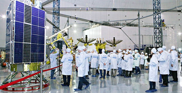
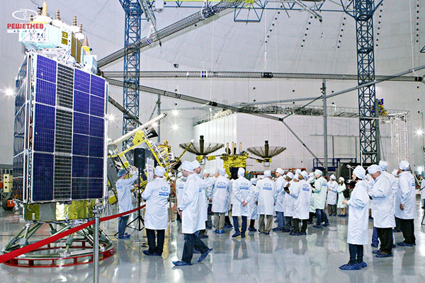
Seminar participants visit the GLONASS production facility. (Photo: Reshetnev)
A United Nations workshop held in Krasnoyarsk, Russia, May 18-22 focused on sharing GNSS in various countries, as well as training in GNSS technologies.
The five-day workshop, organized jointly by the United Nations Office for Outer Space Affairs and the Russian Federal Space Agency (Roscosmos), sought to address the use of GNSS for various applications that can provide sustainable social and economic benefits, in particular for developing countries.
Titled “The use of global navigation satellite systems, GNSS/GLONASS,” the meeting was hosted by the Reshetnev Information Satellite Systems Joint Stock Company. This is the first time the workshop was held in Russia.
A key topic of discussion was the sharing of GNSS in different countries, according to the Reshetnev website. Particular attention was paid to training in the use of satellite navigation, with the most important outcome a proposal to create, under the auspices of the Reshetnev company, an international education center in the use of satellite navigation. The center will cooperate with the UN office in Vienna, as well as regional centers in Morocco, Nigeria, India, Brazil and China.
The seminar was held in nine sections. The sections considered topics such as the formation and development of GNSS, GNSS infrastructure, and national projects on the use of satellite navigation. Representatives from more than 20 countries in Asia, Africa, Europe, North and Latin America shared their experiences implementing GNSS services and spoke about the real and projected benefits of using these technologies for social and economic development.
During the seminar, participants visited the MFReshetnev satellite production company responsible for the space segment of GLONASS in Russia. Guests were shown current and future GLONASS-M and GLONASS-K satellites, as well as learned about the latest developments for GLONASS.
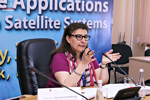
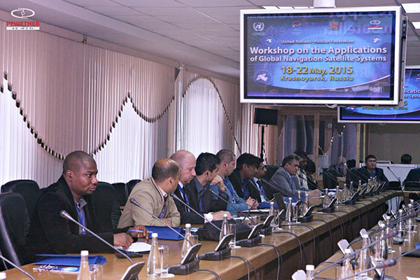
UN representative Sharafat Gadimova summarizes the workshop. (Photo: Reshetnev)Participants discuss the uses of satellite navigation. (Photo: Reshetnev)
A new report by Beecham Research examines how the agricultural sector is embracing precision farming to face challenges raised by an increasing worldwide population and the impact of climate change.
The United Nations predicts the global population will reach 8 billion by 2025, and 9.6 billion by 2050, meaning food production must increase by 70 percent by 2050.
The report explores how agricultural operations are changing through the Internet of Things (IoT) and related smart and connected farms concepts, including precision agriculture guided by GPS. It provides a geographic analysis discussing public policies, adoption drivers and barriers, and opportunities for the M2M/IoT community.
The Executive Summary of the report, “Towards Smart Farming: Agriculture Embracing the IoT Vision,” is available here.
The United Nations and Russia’s space agency ROSCOSMOS are holding a workshop on ways to use GNSS for sustainable social and economic benefits. The workshop will be held May 18-22 in Krasnoyarsk, Russian Federation.
Current and planned projects that use GNSS technology, including the GLObalnaya NAvigatsionnaya Sputnikovaya Sistema (GLONASS) of the Russian Federation, for both practical applications and scientific explorations will be presented. Cooperative efforts and international partnerships for capacity-building, training and research, including the activities of the GLONASS learning center will also be presented.
The workshop program will include plenary sessions described below and also sufficient time for discussions among participants to identify the priority areas where pilot projects should be launched and examine possible partnerships that could be established. In addition, a half-day technical tour will be arranged by the Local Organizing Committee during the workshop.
The workshop is co-organized and co-sponsored by the International Committee on Global Navigation Satellite Systems, and hosted by the Reshetnev Information Satellite Systems Joint Stock Company.
Sessions include:
Session 1: Current and Planned GNSS and Satellite-Based Augmentation Systems
Session 2: GNSS-based Applications
Session 3: GNSS and Space/Atomospheric Weather Monitoring
Session 4: GNSS Reference Frames/Systems and Reference Station Networks
Session 5: Capacity building, training and education in the field of GNSS
In May 2011, Dinesh Manandhar and Hideyuki Torimoto of GNSS Technologies, Inc., Japan, penned a very interesting article in GPS World titled – Opening Up Indoors: Japan’s Indoor Messaging System, IMES. The opening paragraph of their lengthy article seemingly describes the Holy Grail for the indoor positioning lobby:
“An indoor messaging system (IMES) has been developed to meet the challenges of indoor and deep indoor positioning, as a system that can be implemented in any device that has a GPS/GNSS receiver without hardware modification. IMES can provide reliable 3D position data with a single transmitter device without performing range calculation[s].”
They go on to describe the IMES concept thusly:
“The main concept of IMES is to transmit position and floor ID of the transmitter with the same RF signal as GPS. IMES transmits latitude, longitude, height, and floor ID by replacing the ephemeris and clock data in the navigation message of GPS. A single unit of IMES is enough to get the position data, since the position itself is directly transmitted.”
Now, you don’t have to be a rocket scientist to start thinking about interference and spoofing issues or risks, especially when you read that the navigation message ephemeris and clock data are being replaced by data broadcast by IMES. To be fair, the authors address these issues briefly:
“Since IMES shares the same frequency as [the] GPS L1 band (1575.42 MHz), there is an interference level that IMES may have on GPS signals. This interference has been studied in detail by conducting experiments and simulations. Based on these studies and analysis, various methods have been considered to avoid harmful interference to GPS signal. To avoid such interference, IMES center frequency is shifted by +/– 8.2 KHz from GPS L1 band. This will have the least impact on the GPS L1 band signal. For example, if the IMES signal is –110 dBm (very strong) and the GPS signal is –142 dBm (very weak), the loss of GPS signal (C/N0) due to IMES is less than 2 db. If the IMES signal is –120 dBm and the GPS signal is –142 dBm, there is no loss of GPS signal (C/N0). Based on this analysis, the IMES transmitter power must be controlled such that the maximum power to the receiver does not exceed –110 dBm at a distance of 3 meters from the transmitter. [There are] guideline[s] specified in the QZSS IS document for setting the transmitter effective isotropic radiated power (EIRP) based on location.”
Let’s put these concerns in perspective. I thoroughly enjoyed the article and firmly believe that we desperately need to solve the indoor positioning and navigation problems, especially for our warfighters and first responders. While many of today’s excellent commercial receivers work well indoors near windows and doors, they are absolutely abysmal underground and deep inside large buildings with lots of metal, or in the middle of dense urban canyons such as Tokyo, Japan. Without a doubt, there is a dire need for a system like IMES — or maybe exactly like IMES — but there must be some caveats and stipulations as to how the IMES system is implemented.
Not Alone
Fortunately, I am far from being a lone wolf in voicing my concerns and my position, for once again the conspiracy theorists as well as renowned scientist and policy makers are concerned about IMES and the operating systems they supposedly desire to replace or augment. Chief among them is the Father of GPS, Dr. Bradford Parkinson, who has frequently described improperly operated in-band pseudolites as “…just another name for a legal jammer or spoofer.” Having known Brad for almost 40 years, I am convinced few GPS experts in the world today have as much experience with pseudolites as Dr. Parkinson. Consequently, the very reason that an indoor navigation system such as IMES is needed may well be a portent for why it may well fail, unless it is implemented properly.
It would be easy but extremely tedious to write about the numerous issues facing IMES in a complicated and technical manner. Certainly previous articles have become bogged down in minutia, and I want to avoid that. It is actually very simple. The issues are fairly straightforward and should be faced head on and not hidden in the midst of tech-speak lingo, legal jargon, policy minutia or politics. So lets dive straight in, shall w,e and make sure these issues see the light of day?
Interference
There can be no doubt that IMES has the potential to significantly interfere with GPS and QZSS signals. The authors of the IMES article are quite clear concerning the potential for interference, and in their own way attempt to mitigate it with signal power restrictions. Their example of a small three- to four-story building with IMES transmitters may indeed be adequate for signal power mitigations, but what happens in Tokyo where tall buildings — skyscrapers if you will — abound? When the Tokyo Skytree skyscraper opened to the public in 2012, it was then listed as the world’s tallest tower and Japan’s biggest new landmark. At over 2,080 feet tall, this is definitely the type of building where one would need an IMES system. With an average of 20 IMES transmitters per floor and weighing in with over 200 floors, we can quickly see that there would be over 4,000 IMES transmitters in this one building alone, all broadcasting simultaneously on or near the center frequency for GPS. Absent stringent regulations and infinite care (the IMES article authors propose that the pseudolite network operator will have the responsibility to continuously monitor each pseudolite and the pseudolite network to prevent interference), and perhaps even with those caveats in place, the GPS L-band noise floor would be such that GPS signals would be incapable of being received.
Now, put 20 such buildings in a ten-block area and the noise floor would be almost incalculable and certainly not predictable. Dr. Parkinson’s fears are realized; your legalized IMES system becomes a distributed network of jammers and/or spoofers. However, technically IMES is currently far from being a legal jammer or spoofer as currently IMES transmitters are not legal to operate in the GPS band at 1559-1610 MHz under the International Telecommunications Union (ITU) Treaty per the International Table of Frequency Allocations of the ITU Radio Regulations. The ITU further states that IMES currently operates on an interfering basis with the co-primary allocations (ARNS/RNSS) in this band, and therefore are in violation of the ITU Treaty. However, Japan’s frequency regulatory agency can develop and implement regulations that allow IMES operations. When this occurs, if not operated within stringent guidelines, IMES could then be considered a legalized jammer or spoofer.
Even the Joint Research Centre of the European Commission, the JRC, states in its Executive Summary on pseudolites that in-band pseudolites pose a significant jamming risk to GNSS receivers. Specifically they state:
Pseudolites or pseudo-satellites are an emerging technology with the potential of enabling satellite navigation indoors. This technology found several applications that are not limited to indoor navigation. Precise landing, emergency services in difficult environments and precise positioning and machine control are few examples where pseudolite technology can be employed.
Despite the great potential of this technology, severe interference problems with existing GNSS services can arise. The problem can be particularly severe when considering non-participating receivers — legacy devices not designed for pseudolite signals. The design of pseudolite signals is thus a complex problem that has to account for market requirements (modifications of existing receivers for enabling the use of pseudolite signals, measurement accuracy, target application), regulatory aspects (frequency bands to be allocated for pseudolite services) and interference problems.
JRC investigates the main aspects to be considered for the design of a pseudolite signal standard minimizing the interference problem without compromising the location capabilities of the system. The focus is on the signal characteristics and topics relevant for the signal design.
Pseudolite or Communications System
The second technical portion of the interference issue revolves around how exactly you define IMES, for when you are dealing with radio regulation agencies semantics matter. Think back to the first paragraph of this article where the IMES authors defined IMES as a messaging system. That certainly sounds like a communications system to me, and others agree. Consequently, the question has been raised and rightfully so: Is IMES a navigation and positioning system, a pseudolite or a communications system? Honestly, to me it sounds like a bit of all three, but if you define it as a communications system, then Japan is seeking to authorize the integration of a communications system with known significant interference issues with GPS signals right in the middle — indeed, potentially on the center frequency of the protected navigation band using terrestrial PRN codes assigned by the U.S. government. If IMES is deemed an indoor pseudolite, then the interference issues are still there. But it is defined as a bonafide PNT system using authorized terrestrial PRN codes. Talk about a bucket of worms!
The issues here are numerous, and they need to be fully addressed to ensure that all those who are potentially affected clearly understand what is being proposed and the risk for the public at large, including who owns responsibility if something goes wrong. I could go on for several pages on this issue alone, but suffice it to say, we do not want to authorize a communications system that is a known and acknowledged GPS interferer right in the middle of the band — or anywhere in the band for that matter. Remember all the issues GPS had in the past several years with a communications system in adjacent bands. So, do we really want a known communications system — or communications system masquerading as a pseudolite, for that matter — with known GPS signal interference issues in the restricted GPS frequency spectrum? The blaringly obvious answer is absolutely not! Yet this is exactly what the IMES authors are proposing not only for Japan, but eventually, if they receive authorization, for other countries around the globe as well. Japan has twice petitioned the U.S. government to make the assigned IMES terrestrial PRN code allocations global in nature. Fortunately, to date those request have been denied.
Dichotomy
Certainly, other countries and companies have noticed this apparent frequency authorization dichotomy and are following suit. For instance the Conference of European Postal and Telecommunications agencies, or CEPT, which is Europe’s regional representative to the World Radiocommunication Conference (WRC), has proposed adding several troubling IMES-related agenda items for the quadrennial WRCs coming up in 2015 and 2019. Even more importantly, these critical issues could be aired in the next three weeks, as the agenda for the 2015 WRC will be largely set at a plenipotentiary conference happening October 20 through November 8 in Busan, South Korea.
There are what I consider to be dangerous proposals under consideration by the ITU (International Telecommunication Union), which should concern GNSS users worldwide. The ITU is the United Nations’ specialized agency for information and communication technologies — ICTs. This is the ITU, where every member state (currently 193) gets one vote, whether they fully understand the technical issues or not and regardless of whether they are a space-faring nation or have a dog in the fight, so to speak. This means that the vote of tiny Saint Lucia counts the same as the United States or Canada or Australia. The ITU charter is to “…allocate global radio spectrum and satellite orbits, develop the technical standards that ensure networks and technologies seamlessly interconnect, and strive to improve access to ICTs to underserved communities worldwide.” Fortunately, the ITU regulations, unlike the CEPT or IMES proposals, wisely require new transmitters proposing to operate in the radio navigation spectrum to operate without causing interference to primary users. Meanwhile, there are member states, countries and companies that want to capitalize on this seeming dichotomy within the global safety-of-life, historically protected, radio bands. Those nefarious efforts, for the future of GPS and GNSS worldwide, need to be stopped in their tracks.
Spectrum is a limited and valuable resource, to say the least, and here fortunately the ITU regulations have it right and do not risk human life, by intruding and potentially interfering with the frequencies used globally by airliners to control, route and land aircraft. I am convinced there are solutions available to us through cooperative efforts with the ITU and other national organizations that will produce pseudolites without causing interference in the protected safety-of-life frequency bands.
When Is a PRN Code Not a PRN Code?
Some of you who are a bit more savvy or have been following this fiasco for some time may now be thinking, what’s the problem, the IMES authors are merely using and proposing further use of U.S. government-authorized terrestrial PRN codes for IMES. This indeed touches on the third thorny issue, which is not only technical but political as well — the use of and authorization to use PRN codes for what is ostensibly a communications system, if you believe the authors of the IMES article, who go to great lengths to differentiate IMES from pseudolites. They continually make the argument that IMES is not a pseudolite, but as we shall soon see, when the U.S. government authorized these specific PRN codes (173-182) for Japan, they were to be used solely for a low-power terrestrial pseudolite program, not an in-band communications system.
Technically, these specific PRN codes assigned to the Japanese for IMES expire in 2017. The authorization of these PRN codes come with numerous restrictions that legally make the codes useful only for the Japanese landmass. This is where the technical, political and operational issues come to a head. We are in for some tough sledding here. However, I will endeavor to make it as simple as possible.
History
In 2007, ten PRN codes were specifically assigned to the Japan Aerospace Exploration Agency or JAXA “for the Indoor Messaging System (IMES) terrestrial pseudolites of the Quasi-Zenith Satellite System (QZSS).” The Memorandum of Agreement from the GPS Wing at SMC (Space and Missile Systems Center) in Los Angeles at Los Angeles Air Force Base (LAAFB) clearly states that the codes are valid for ten years and expire on 19 November 2017, unless a renewal application is filed and approved. Hence, PRN codes 173-182 for IMES were assigned with several crucial caveats and restrictions by the U.S. government that are definitely pertinent to our discussion:
The codes are designated for low-power terrestrial regional applications limited to Japan only.
Although the GPS Wing conducts an initial check on PRN number requests with respect to potential interference issues, the issuance of a PRN number does not convey authority to radiate in the [GPS] band. In order to radiate in the GPS L1 band, the applicant [Japan] shall obtain a frequency assignment from the [Japanese] national authority.
The GPS Wing assumes no responsibility for ensuring systems using these spreading codes follow domestic radio frequency regulations or other applicable laws or regulations, or for ensuring that systems using GPS PRN codes do not cause radio frequency interference.
GPS PRN codes were developed for signals transmitted from satellites, and are not necessarily optimized for use by terrestrial transmitters.
The maximum effective isotropic power for each terrestrial transmitter will be less than -94 dBW.
The QZSS [organization] is responsible for the redistribution of these spreading codes throughout Japan and will limit their use to Japan only.
With all these restrictions, it is difficult to see how the IMES authors could legally use, distribute or promote authorization of IMES and the use of the PRN codes outside of Japan and at the power levels related in the GPS World IMES article. Regardless of the IMES author’s interpretation of the PRN code assignment, the GPS Wing 2007 Memorandum restrictions and caveats are clear, and it cannot be disputed that the codes expire in 2017 unless renewed by the USAF. The PRN codes are restricted to the landmass of Japan even if they are renewed, and if IMES wishes to broadcast anywhere in the GPS band, they need to have permission from their national frequency allocation authority (the Ministry of Internal Affairs and Communications, which is equivalent to the U.S. FCC –Federal Communications Commission) to do so.
The Way Ahead
This is the easy part from my perspective. See if you don’t agree. If the U.S. government is concerned about IMES and what Japan is planning to do with the assigned PRN codes for terrestrial use, the U.S. government through the USAF has the options to:
Rescind the PRN codes immediately.
Insure the Japanese adhere to the caveats and restrictions in the original Memorandum.
Simply refuse to renew or recertify the codes for future use and/or recommend for IMES frequencies that are outside the protected GPS band.
Update and clarify the footnote on the GPS Wing PRN Codes website pertaining to the Japanese IMES PRN Codes with all the restrictions listed in the GPS Wing Memorandum so other countries will realize this is not a global IMES PRN assignment.
Japan is a valuable ally and we need to work together cooperatively, but frankly, the plans laid out for IMES by the authors in the GPS World article must be troubling to those whose job it is protect the GPS spectrum and enforce mutual agreements with our allies. If we were just concerned about a Japanese IMES system, this whole discussion might be moot. However, other countries and commercial companies around the world are watching closely and laying the groundwork for similar IMES and pseudolite incursions into the GPS L-band spectrum — if the Japanese are allowed to proceed and the limited use of PRN codes for IMES is not clarified for all. No one, and I include the Japanese, wants to see this happen if it means interference with GPS, and QZSS for that matter.
Fortunately, where European countries are concerned, there are the ITU regulations. Specifically for GPS and pseudolites, the CEPT regulation has a license condition that requires the pseudolite network operator to submit to the European country regulator confirmation of the terrestrial PRN codes from the GNSS operator before operating pseudolites in the GPS band. So again, the U.S. government wields the hammer here.
Therefore, the U.S. government must act immediately and decisively to put an end to the threats against the protected GPS spectrum caused by the proposed in-band IMES system. At the same time, the Japanese government has an obligation and responsibility to adhere to the letter of the law where the original GPS Wing 2007 IMES Memorandum is concerned.
Finally, the U.S. government must urgently engage cooperatively with the European Union administration and Japan to prevent the authorization and proliferation of interfering devices in the GNSS frequency bands, and to work together to ensure the positive benefits to GNSS from commercializing pseudolite uses outside the GNSS radio frequency bands. GNSS manufacturers worldwide are successfully marketing commercial pseudolites that do not cause interference. In my opinion, this is the way to go both in terms of regulations and governance.
Until next time, happy navigating, and remember GPS is brought to you free of charge by the United States Air Force.
The United Nations is spotlighting the benefits of satellite navigation and its contribution to the betterment of humankind as part of the observance of World Space Week — an annual global celebration of the contributions of space science and technology to humanity.
The theme of this year’s World Space Week is Space: Guiding Your Way. It highlights the benefits of satellite navigation to society, which Simonetta Di Pippo, director of the UN Office for Outer Space Affairs (UNOOSA), said are of “great importance” to her office. UNOOSA also functions as the Executive Secretariat to the International Committee on Global Navigation Satellite Systems (ICG), which promotes voluntary cooperation on civil satellite-based positioning navigation, timing and value-added services.
Proclaimed by the UN General Assembly in 1999, World Space Week, observed each year during the week of October 4-10, aims to provide unique leverage in space outreach and education; educate people around the world about the benefits that they receive from space; encourage greater use of space for sustainable economic development; demonstrate public support for space programs; excite young people about science, technology, engineering, and math; and foster international cooperation in space outreach and education.
The dates recall the launch on October 4, 1957, of the first artificial satellite, Sputnik I, and the entry into force, on October 10, 1967, of the Treaty on Principles Governing the Activities of States in the Exploration and Use of Outer Space including the Moon and Other Celestial Bodies.
Ideas for educators and youth groups to focus on satellite navigation include geocaching, building model satellites, and using Google Earth. “Imagine a world without navigation satellites to guide planes, ships and cars and not to forget: us with our location-based mobile phone applications!” the guide states. “And navigation satellites not just accurately pinpoint our position on the planet, it also provides time signals to keep clocks in sync, which is critically important for global trading and many other time critical sectors. In times of disaster navigation satellites help rescuers quickly find spots where people need help. Using Geographic Information Systems (GIS) we can compare maps before and after things changed. And GNSS satellites are important to help you planning your trips and tell you where it will rain and where it will shine!”
Can GPS be used to detect underground nuclear explosions?
A research team is developing a software program that uses GPS to analyze the ionospheric effect of nuclear explosions. Results would show when and where a country has conducted a secret underground nuclear test. Team members are Jihye Park, Ralph. R. B. von Frese, and Dorota A. Grejner-Brzezinska from The Ohio State University and Jade Yu Morton from Miami University.
The Comprehensive Nuclear-Test-Ban Treaty was adopted by the United Nations General Assembly in 1996, but not all nuclear countries have ratified it, including the United States, China, Egypt, Indonesia, Iran, and Israel. Also, India, North Korea, and Pakistan have not signed the treaty.
Park, a doctoral student in geodetic science at Ohio State, created the computer program to detect changes in the ionosphere from nuclear weapons testing.
A previous study showed that the ionosphere was disturbed by underground nuclear testing conducted by Russia in 1990. GPS is capable of precisely measuring the total electron content (TEC) of the ionosphere along the path between satellite and receiver at a GPS station, so Park and her team decided to begin researching the use of GPS in detecting nuclear explosions.
“Many studies have been done to monitor and model the atmosphere using GPS technology,” Park said. “Research has proven that GPS can detect natural disasters such as earthquakes or tsunamis. This study broadens those areas of study with its capability to detect underground explosions.”
Detonation of a nuclear weapon results in a shockwave that travels through the atmosphere, changing the density of charged particles in the ionosphere. “The explosions can’t hide from the ionosphere,” said von Frese, geophysicist and project leader. “Our technology would be another nail in the structure to detect explosions.”
“One of the arguments is ‘Well, how do you prove that a clandestine explosion occurred?’” said Grejner-Brzezinska, Park’s adviser and GPS World’s Tech Talk blog editor. “Now we can say, ‘Here, we have the data from GPS to show when and where.’”
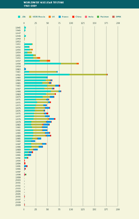
According to the Comprehensive Nuclear-Test-Ban Treaty Organization (CTBTO) nuclear testing has been carried out in the past by the United States, Russia, the United Kingdom, France, China, India, Pakistan, and North Korea (see Figure 1).
Researchers, and those monitoring treaty violations, are able to target specific geographic areas that are equipped for tests, since development of a nuclear test site requires a lot of technical effort and budget. For example, the North Korean tests carried out in 2006 and 2009 were very close geographically.
“They tend to stick to the same site and reuse their facilities for nuclear testing,” von Frese said. “So a country that has previously conducted underground nuclear testing probably will reuse the site if new testing is needed.”
“They could be monitored using GPS as long as there are GPS stations nearby,” Park said.
The new GPS nuclear-detection technology was presented at the Comprehensive Nuclear-Test-Ban Treaty Organization meeting held June 8–10 in Vienna, Austria, and received press coverage that drew additional interest.
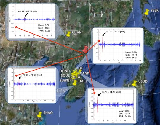
GPS Detection. The team zeroed in on a specific event to test the software, selecting a nuclear test conducted by North Korea in 2009 and using data pulled from nearby South Korean GPS stations.
Traditional detection methods for underground nuclear tests include seismic and other sensors. The CTBTO operates an international monitoring system to detect explosions with a yield of at least one kiloton. Besides seismic sensors, monitoring includes hydroacoustic sensors to monitor for shockwaves on land and in water, infrasound to detect pressure waves, and radionuclide detectors for any gas that may have been generated, though the levels aren’t always detectable.
“Even though there are four different systems available, they sometimes are unable to detect the underground nuclear explosions,” Park said. “GPS technology will make the detection validation stronger since each of them is based on a different theory. In the case of the nuclear test conducted by North Korea in 2009, only seismic and a few infrasound sensors detected the event because of their improved containment technique. Our study tracked down the 2009 event using GPS, and found it coincided with the seismic results.”
Park was able to take advantage of the well-established worldwide infrastructure already in place for GPS for her software test. The team used GPS data recorded by South Korean GPS receivers of the 2009 North Korea test. “There are a few IGS (International GNSS Service) stations in South Korea, China, and Japan. Since South Korea runs their own GPS network, I requested the data so that we could obtain data from more stations located in South Korea,” Park said.
“Since the stations we chose were permanent reference stations controlled by an international organization (IGS) and a specific country (Republic of Korea or South Korea) respectively, most of them have been running continuously except for unexpected data gaps from time to time,” Park said. Figure 2 shows the GPS stations processed for the project.
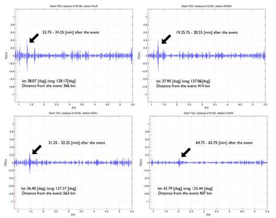
With data in hand, Park was able to test her software. The results showed definite peaks from different stations at different times after the 2009 explosion. “We realized that the time of the detected peak was dependent on the distance between underground nuclear explosion and each GPS station,” Park said. Figure 3 shows four different stations’ TIDs (traveling ionospheric disturbances) that the team initially recognized.
Figure 3. Traveling ionospheric disturbances (TIDs) detected at stations INJE (top left), DOND (top right), DAEJ (bottom left), and CHAN (bottom right). Click to enlarge.
Ruling Out Quakes. One big challenge using GPS for ionospheric monitoring is determining the origin of an event. “Since earthquakes also disturb the ionosphere, distinguishing earthquakes from underground nuclear explosions are problematic even with GPS,” Park said. “Indeed, we only focused on examining and isolating TIDs from the nuclear explosions. We are now working to analyze the TIDs from earthquakes and compare them with nuclear TIDs.”
Besides helping to distinguish between earthquakes and nuclear-test explosions, the software may eventually distinguish between nuclear plant fallout and nuclear test fallout.
With this goal in mind, the team is analyzing the ionospheric data gathered from recent nuclear plant accidents such as the one in Japan following the earthquake and tsunami in March. “Since there were data gaps and other data issues, we have as yet nothing more to report. Hopefully, we find the earthquakes’ signature soon.”