Tag: United States Geological Survey

  • Seen & heard: Mapping the melting arctic and India’s war on drugs

    Seen & heard: Mapping the melting arctic and India’s war on drugs

    “Seen & Heard” is a monthly feature of GPS World magazine, traveling the world to capture interesting and unusual news stories involving the GNSS/PNT industry.


    Mapping the melting Arctic

    Image: TT / iStock / Getty Images Plus / Getty Images
    Image: TT / iStock / Getty Images Plus / Getty Images

    According to the 2023 Arctic Report Card by the National Oceanic and Atmospheric Administration (NOAA), new records have been documented showing that human-induced warming of the atmosphere, ocean and land is creating adverse impacts on people, ecosystems and communities across the Arctic region. The report states the Arctic is experiencing a faster rate of warming than any other part of the world. Overall, it was the Arctic’s sixth-warmest year on record. Sea ice extent continued to decline, with the past 17 Septembers now registering as the lowest on record.


    GNSS enhances landslide monitoring in China

    Image: pananba / iStock / Getty Images Plus / Getty Images
    Image: pananba / iStock / Getty Images Plus / Getty Images

    Researchers from Chang’an University in China have developed a new method of tracking landslides. The team combined GNSS precise point positioning (PPP) techniques with a cumulative sum control chart (CUSUM) method. Conducted at the Tengqing landslide in Liupanshui, Guizhou Province, Southwest China, the study aims to enhance the precision in tracking the movements of the landslides and improve the overall reliability of the monitoring results.


    Crabs on the move

    Image: United States Geological Survey (USGS)
    Image: United States Geological Survey (USGS)

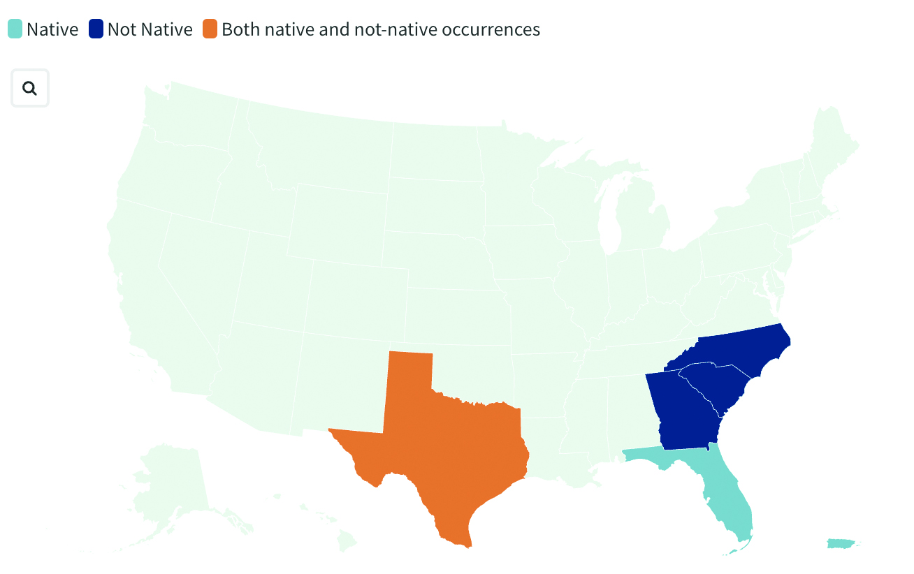
    Georgia officials are asking the public for help in spotting non-native blue land crabs as they appear to be moving north in recent years, according to data collected by the United States Geological Survey (USGS). According to USGS, it is unclear whether this movement is driven by humans or by the crabs themselves, or if the crabs are breeding in their non-native homes. Officials worry about the damage caused by the crabs’ burrowing behavior. While scientists learn about how the species interacts with its new environment, several states are asking residents to report sightings.


    India’s war on drugs

    Image: evandrorigon / E+ / Getty Images
    Image: evandrorigon / E+ / Getty Images

    India’s border security force (BSF) has said it is battling an unprecedented UAV “menace” infiltrating the border with Pakistan, fueling the drug crisis in the state of Punjab and raising serious security issues, reported The Guardian. UAVs have dropped weapons such as pistols and Chinese-made assault rifles, as well as consignments of opium and heroin believed to be from Afghanistan.

  • Aftermath of the Türkiye Earthquakes

    Aftermath of the Türkiye Earthquakes

    Image: Judy Dillon/iStock/Getty Images Plus/Getty Images
    Image: Judy Dillon/iStock/Getty Images Plus/Getty Images

    The Mw 7.8 and Mw 7.5 Kahramanmaraş Earthquake Sequence struck near Nurdağı, Türkiye, on Feb. 6. It collapsed several buildings and has claimed more than 50,000 lives. The impact of the initial earthquakes was very severe, but to make matters worse, later in February, a Mw 6.4 tremor struck near Antakya, a city near Türkiye’s border with Syria. This created further damage to infrastructure and claimed more victims.

    Image: Screenshot of video from NBC News
    Image: Screenshot of video from NBC News

    The Specifics

    The United States Geological Survey reports that the earthquake resulted from strike-slip faulting at shallow depths. The earthquake sequence displaced numerous fault segments within the East Anatolian Fault zone. Early estimates indicate about 185 miles of fault length ruptured. Parts of the North Anatolian Fault shifted 10 feet, while segments of the East Anatolian Fault slid more than 30 feet.

    Historic Site Suffers

    Gaziantep Castle dates back to the second millennium B.C. It has been used in many capacities throughout history, and more recently, stood as a museum for visitors to learn about its rich history. The castle was reduced to rubble in the earthquake. Other historical sites that sustained damage include the Yeni Mosque and the ancient city of Aleppo in Syria.

    Image: Screenshot of CNN video
    Image: Screenshot of CNN video

    Earth Opens Up

    The earthquake destroyed cities all over Türkiye and northern Syria, but they are not the only areas that suffered dramatic effects. A verdant olive grove in Tepehan, Hatay Province, Türkiye, was completely divided when the ground split, creating a 984-foot-long valley in the middle of the grove. The valley is more than 130 feet deep and has created issues for the 7,000 people that inhabit the area.

  • Esri book highlights analyzing, mapping surface water features

    Esri has published its latest book, “GIS for Surface Water: Using the National Hydrography Dataset,” by Jeff Simley, which details how to use geographic information system (GIS) technology to visualize and analyze data sets. Simley is an award-winning cartographer and the former lead of the Hydrography Program at the United States Geological Survey (USGS).

    The book examines the complexities of surface water systems and shows readers how to use the Esri ArcGIS software, the USGS’s National Hydrography Dataset (NHD) and the Watershed Boundary Dataset (WBD), and the U.S. Environmental Protection Agency’s NHDPlus dataset to better study and manage the United States’ vast water system.

    According to Esri, the book thoroughly examines the representation of water features and their attributes in a GIS and then turns its attention on how that data is structured in the NHD, WBD and NHDPlus datasets. In addition, after seeing how surface water hydrography can be modeled in a GIS, readers can then learn how to use these tools to solve real-world problems, such as protecting and restoring the fisheries habitat in Washington.

    The book also offers instructions to guide readers to create surface water flow-volume maps that show how much water flows through any given river system.

    “This book is unique in that it is the most comprehensive, authoritative source for the NHD,” said hydrologist David Maidment in the book’s foreword. “But it is more than that: It is a monument to the intellectual craft and dedicated effort of a generation of digital mapmakers who devoted their professional careers to the completion of this enormous task.”

  • Woolpert contracted by USGS to map, survey throughout US

    Woolpert has signed a five-year, multimillion-dollar Geospatial Product and Services Contract 3 (GPSC 3) with the U.S. Geological Survey (USGS) to provide mapping and surveying services.

    The GPSC is a suite of contracts used by federal, state and municipal government entities to partner with USGS for the purpose of fulfilling their geospatial data requirements.

    The contract will be administered through the National Geospatial Technical Operations Center (NGTOC) in an effort to obtain geospatial data services throughout the United States and its territories. The contract also will be used to support the 3D Elevation Program (3DEP) and used by other federal, state and local agencies.

    “This provides Woolpert with the opportunity to continue working with USGS on their 3D Elevation Program (3DEP), an eight-year program to provide highly accurate 3D elevation data of the entire U.S.,” said John Gerhard, Woolpert project director. “This data will be collected via lidar (light detection and ranging) to create the most accurate surface model, and will be used to evaluate flood risk and natural resources, support FEMA, help farmers with precision agriculture, assess and manage infrastructure, and much more.”

    Jeff Lovin, Woolpert senior vice president and director of government solutions, said the Woolpert staff is proud to have had the opportunity to work with the USGS for nearly 25 years. “Over those 25 years, we’ve had the opportunity to collaborate on different layers of the National Spatial Data Infrastructure (NSDI), from the development of nationwide imagery in the 1990s to 3D elevation and hydrography today,” Lovin said.”It’s very gratifying to have the opportunity to play a part in such an important program for our nation.”

  • OGC announces Arctic Spatial Data Infrastructure Project

    The Arctic SDI Pilot is sponsored by the United States Geological Survey (USGS) and Natural Resources Canada. The goal is to demonstrate to Arctic stakeholders the diversity, richness and value of a Spatial Data Infrastructure (SDI) based on web services and standardized exchange formats in helping address critical issues impacting the Arctic.

    Stakeholders include national and pan-Arctic science and monitoring organizations and decision makers engaged in Arctic research, social and economic policy, and environmental management. The organizations participating in the ArcticSDI Pilot will document and publicize best practices that can support a rich network of web-accessible data and service resources for the Arctic.

    The pilot has two phases.

    Phase 1, an OGC Interoperability Program Concept Development study, began in December 2015. In Phase 1, project planners are building an inventory of currently available Arctic geospatial data layers and web services and defining the Arctic SDI architecture. This work will be supported by partners engaged in industry, research, and numerous jurisdictions. A Request for Information will be published in January 2016 to elicit further ideas, experiences, and projects in industry, research institutions and public administration to make maximal use of the ArcticSDI and to develop it further.

    The Arctic SDI Pilot Phase 1 will also provide direct input into OGC’s major Testbed 12 Interoperability Program initiative. USGS has indicated that sponsor funding will be made available for Testbed 12 to test and further develop components identified in the Arctic SDI pilot. Through this collaboration, arctic stakeholders and the Arctic SDI will leverage and benefit from the leading-edge interoperability research, development and outreach that is ongoing in the OGC’s series of major testbeds.

    All findings from Phase 1 will serve as input for Phase 2, which will be an OGC Interoperability Program Pilot Project. OGC pilot projects apply and test OGC Standards in operational applications using Standards Based Commercial Off-the-Shelf (SCOTS) products that implement OGC Standards. Pilot projects provide an operational implementation so that users and technology developers can collaborate and learn how to better address their requirements using standards-based architectures.

    To articulate the value of interoperability via standards, technology provider participants will implement the recommended Arctic SDI architecture in support of Arctic policy scenarios. A video will be produced to engage policymakers on the benefits of integrating diverse data utilizing Arctic SDI standards and information management best practices.

    The OGC is an international consortium of more than 515 companies, government agencies, research organizations, and universities participating in a consensus process to develop publicly available geospatial standards. OGC Standards support interoperable solutions that “geo-enable” the web, wireless and location-based services, and mainstream IT. OGC Standards empower technology developers to make geospatial information and services accessible and useful with any application that needs to be geospatially enabled.

  • Avenza Adds USGS US Topo Maps to PDF Maps App

    Thumbnail image of the 2015 Tupelo, Mississippi 7.5 minute series quadrangle (1:24,000-scale), US Topo map (orthoimage layer off)The United States Geological Survey (USGS) continues to support the delivery of its digital maps through Avenza Systems Inc.‘s PDF Maps app. It has widened the selection to more than 120,000 US Topo topographic maps on its digital mapping platform, which provides digital users access to USGS’ rich map content and extends its reach with a growing base of mobile consumers.

    The app currently aids a growing number of people who reference digital devices for work or recreation. Travelers, scientists and conservation and environmental decision makers already make use of USGS topo maps, but the expanded use of the maps via the PDF Maps app provides current USGS topo map users the ability to digitally access maps in areas with little to no internet reception and input notes and images within the map all while tracking current position.

    The USGS produces US Topo maps on a continuous basis with more than 18,000 revised quadrangles produced every year. Currently, thousands of maps from USGS’s extensive library are now available in Avenza’s PDF Maps database, including the most current variations that reflect the changing landscape of the country.

    Many historical maps can also be accessed, with thousands more dating back 130 years being added in the near future, according to Avenza. The app provides constant access to geographic information and points of interest, with additional interactive features such as measuring, place marking and location tagging. Avenza’s PDF Maps app operates without the risk of lost reception due to cell tower proximity, making it the ultimate traveling tool since it does not rely on an internet connection to use map data and obtain and display location.

    “Distinguished map publishers like the USGS fully recognize the shift to digital and how consumers are accessing and consuming information that was once static and digitally implementing it into their daily lives and making it more interactive,” said Ted Florence, president of Avenza Systems Inc. “Avenza’s PDF Maps app is an example of how a digital tool can expand the utility of a map beyond location guidance; it is also a tool to capture an experience in real-time. As the industry continues to evolve to fit into the world of a mobile consumer, we look forward to strengthening our ties with groups like the USGS.

    PDF Maps app 2.6 is available on the iTunes App Store free of charge for personal and private use. PDF Maps app is also available for use with Android devices in the Google Play Store free of charge for personal non-commercial use. A Windows version is currently in public beta targeted for a release later this year.