The United States has begun investigating the unauthorized release of two highly classified intelligence documents detailing Israel’s preparations for a potential retaliatory strike against Iran. These documents, reportedly prepared by the National Geospatial-Intelligence Agency, are marked as top secret and intended for distribution only among the U.S. and its “Five Eyes” intelligence partners: Australia, Canada, New Zealand and the United Kingdom.
The leaked files, which first surfaced on the messaging app Telegram, were shared by an anonymous user known as “Middle East Spectator.” According to CNN reports, the leaked files include a satellite imagery analysis of Israeli military asset movements from Oct. 15-16, 2024, as well as defense plans made by the Israeli Air Force and Navy.
The first document is titled: “Israel: Air Force Continues Preparations for Strike on Iran and Conducts a Second Large-Force Employment Exercise.” The second is titled: “Israel: Defense Forces Continue Key Munitions Preparations and Covert UAV Activity Almost Certainly for a Strike on Iran.”
When asked about the leak during an interview with CNN, House Speaker Mike Johnson said an “investigation (is) underway, and I’ll get a briefing on that in a couple of hours. We are following it closely.” The New York Times reported that officials privately acknowledged that the documents were authentic but that they likely only represent a portion of the information the U.S. has on its close ally’s planning.
The FBI, Pentagon and U.S. intelligence agencies are collaborating on the investigation, focusing on determining who had access to the documents and assessing whether the leak was intentional or the result of a hack.
U.S. officials have acknowledged the documents’ authenticity but suggest they may represent only a portion of the information the U.S. possesses regarding its ally’s plans.
The incident has raised concerns about the security of classified information within the U.S. government.
Combatting electronic warfare and emerging threats
From swarms of lurking UAVs to breaches of federal privacy, we are witnessing a new era of electronic warfare and security challenges. As evidenced by a series of concerning incidents in recent years, the U.S. is actively seeking ways to defend against and secure its airspace from unauthorized UAV incursions and breaches of privacy.
In 2021, the U.S. experienced a record 1,862 data breaches, a 68% increase from previous years. In 2023, Langley Air Force Base in Virginia reported multiple sightings of unidentified UAVs flying above the facility. These incidents raised significant security concerns among military officials and lawmakers. The situation escalated in October 2024 when U.S. officials confirmed similar drone swarm observations near Edwards Air Force Base in Nevada. The Department of Defense (DOD) has not publicly identified the source behind these surveillance drones.
The DOD has launched Replicator 1 and Replicator 2 programs, allocating significant funding to enhance drone warfare capabilities. Replicator 1 focuses on increasing the production of attack UAVs, while Replicator 2 aims to improve defenses against enemy drone attacks.
Outside of the U.S., c-UAV systems and operations have become a critical component of modern warfare and security. While we typically focus on GPS jamming and spoofing as important aspects, they represent only a portion of this style of warfare.
The ongoing advancements in electronic warfare underscore the need for continued research, development, and policy adaptation to address the complex challenges posed by UAV technology in modern warfare and security operations worldwide.
In one of my previous columns, I described the National Geodetic Survey’s (NGS) plans for replacing the North American Vertical Datum of 1988 (NAVD 88) with the North American-Pacific Geopotential Datum of 2022 (NAPGD2022).
As stated in the NOAA Technical Report NOS NGS 64 Blueprint for the Modernized NSRS, Part 2: Geopotential Coordinates and Geopotential Datum, November 2017, recently revised in February 2021, orthometric heights in NAPGD2022 will be defined through ellipsoid heights and GEOID2022. This means NAPGD2022 orthometric heights will primarily be accessed through GNSS technology.
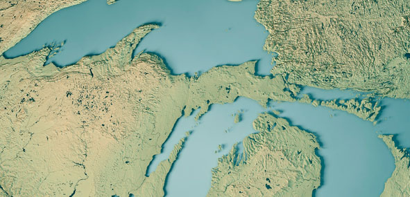
Like NAPGD2022, in the next update of the International Great Lakes Datum, denoted as IGLD (2020), the heights in the Great Lakes Region will be developed from GNSS and a gravity model. Unlike NAPGD2022, where users will be estimating GNSS-derived orthometric heights, IGLD (2020) users will be estimating GNSS-derived dynamic heights using GNSS and a gravity model.
Promote a better understanding of geodesy as a science;
Create a better appreciation of the value of geodetic surveys and thus encourage greater use of such surveys;
Promote geodetic surveys by individuals, government, and private organizations;
Foster the adoption of uniform standards and procedures for completing geodetic surveys;
Promote the processing, publishing, and disseminating of geodetic survey data and information;
Promote programs for testing, calibrating, and evaluating geodetic equipment;
Further the development and implementation of the Global Navigation Satellite System (GNSS) for geodetic, land surveying, and land information system applications;
Inform the membership of new technical developments by meetings of the association and publications in Surveying and Land Information Science (SaLIS);
Promote educational programs in geodesy, geodetic surveying, and related fields;
Cooperate with other similar organizations, both national and international, in support of the science of geodesy;
Encourage the use of geodetic surveys and mathematical coordinate systems in establishing Public Land Survey System (PLSS) corners
As stated above, AAGS cooperates with other similar organizations, both national and international, in support of the science of geodesy. AAGS is a voting member of FIG, which means AAGS has the opportunity to nominate and vote for elected officials, and develop policy that is important to all surveyors and mappers.
The theme of the FIG Working Week 2021 virtual conference was “Smart Surveyors for Land and Water Management: Challenges in a New Reality.” FIG Commission 5 focuses on meeting the highest level of accuracy for positioning and measurement (see box titled FIG Commission 5). Five 90-minute sessions described some of the efforts of FIG Commission 5.
“FIG Commission 5 focuses on meeting the highest level of accuracy for positioning and measurement. It provides the tools, techniques and procedures to educate and train surveying professionals everywhere. Appropriate methodology for data collection and processing are required to be successful in an era of global, integrated geospatial data.”
These sessions raised surveyor awareness of cutting-edge technology, techniques and procedures for using geodetic data and enhanced global cooperation and standardization in conformance with the ideals expressed by the United Nations resolution for a Global Geodetic Reference Frame. There were many good papers on positioning and measurement presented at the virtual meeting. Readers can obtain a list of presentations and papers at this website.
A paper by Jacob Heck, U.S National Geodetic Survey, and Michael Craymer, Canada Geodetic Survey titled “Updating the International Great Lakes Datum: Enabling the Integration of Water and Land Management in the Great Lakes Region” should be of interest to many U.S. and Canadian surveyors. The box below provides a link to the abstract, paper, handouts and video of the presentation.
05.1 – Managing the Land/Water Interface: WGS84 vs. the ITRS
Commission: 4 and 5
Chair: Dr. Mohd Razali Mahmud, FIG Commission 4 Chair, Malaysia
Rapporteur: Dr. Daniel Roman, FIG Commission 5 Chair, United State
Jacob Heck (U.S.) and Michael Craymer (Canada):
Updating the International Great Lakes Datum: Enabling the Integration of Water and Land Management in the Great Lakes Region (11046)
[abstract] [paper] [handouts] [video]
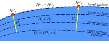
The International Great Lakes Datum uses dynamic heights instead of orthometric heights traditionally used for elevations on land. Figure 4 from Heck and Craymer’s FIG paper, illustrates the difference between orthometric and dynamic heights. See box titled “Figure 4 from FIG Paper by Heck and Craymer.” As described by Heck and Craymer, “The dynamic height represents the difference in potential above the reference surface and is the same at all points on a level surface. Orthometric height represents the actual physical distance above the reference surface which may change due to differences in gravity caused by the convergence of equipotential surfaces toward to the poles. Dynamic heights are therefore required for the proper management of water levels and flows in compliance with international regulations and treaties.”
Figure 4 from FIG paper by Heck and Craymer
Figure 4. Dynamic heights,HD, and orthometric heights, H. (from FIG 2021 paper by Heck and Craymer)
I would like to highlight, as described in the paper and stated in the summary, that access to the future IGLD will be primarily through GNSS techniques.
The International Great Lakes Datum provides a framework for water level management in the world’s foremost resource of surface freshwater. The current datum, IGLD (1985), is being updated and replaced by IGLD (2020). This updated datum will be fundamentally different in terms of definition and access to the datum. The datum will be identical to the new NAPGD2022 North American geopotential datum and will be compatible with the existing CGVD2013 (if not identical as well) at the reference epoch of 2020. IGLD (2020) is expected to be released in 2025 at about the same time as NAPGD2022. Access to both frames will be primarily through GNSS techniques. This will lead to more consistent heights across the entire Great Lakes region. Further information about the IGLD update can be found on the Coordinating Committee website.
This new paradigm is important for anyone who works in the Great Lakes region. Actually, it is important to anyone that surveys in the United States, because this new paradigm will also be used to access the North American-Pacific Geopotential Datum of 2022 (NAPGD2022). Anyone following my columns knows this is the future, and that the National Geodetic Survey (NGS) is leading the way in the United States by modernizing the National Spatial Reference System (NSRS).
Another section that I’d like to highlight is in the box titled “Excerpt from Heck and Craymer Paper on IGLD.”
For IGLD (2020), the geoid height, N, will be provided by GEOID2022 which will be used to define NAPGD2022 and the expected update to CGVD2013. IGLD (2020) dynamic heights will therefore be equivalent to dynamic heights in NAPGD2022 and CGVD2013 at the 2020 reference epoch. For IGLD (2020) heights of water levels, hydraulic correctors may also need to be applied.
An important advancement in the development of the new IGLD and North American datums will be the availability of an accurate crustal velocity model that can propagate ellipsoidal heights between different reference epochs. This will enable heights determined at any epoch to be propagated back to the adopted 2020 reference epoch used for IGLD (2020). This will effectively obviate the need to update the entire IGLD datum for the effects of GIA for a much longer period of time, except for incremental improvements to the velocity model and updates to the reference epoch.
It’s important for users to know that the IGLD (2020) dynamic heights will be equivalent to dynamic heights in NAPGD2022, and an accurate crustal velocity model will be used at any epoch to propagate back to the adopted 2020 reference epoch. The box titled “Determining Heights in IGLD (2020)” is an excerpt from Heck and Craymer’s FIG paper that describes the process that will be implemented for estimating GNSS-derived dynamic heights in the updated IGLD (2020).
In previous realizations of IGLD, spirit leveling was used to determine geopotential numbers which were converted directly to orthometric heights that could then be converted to dynamics heights using equation 4 (𝐻𝐷 =𝐶/𝛾45).
In the geoid-based IGLD (2020), heights will be primarily determined through GNSS techniques which provide a direct measure of ellipsoidal height. Although spirit leveling is more accurate over shorter distances, GNSS methods combined with an accurate geoid model are capable of providing more accurate heights over moderate to longer distances at a small fraction of the cost of leveling.
An orthometric height, H, above the geoid is obtained from a GNSS-derived ellipsoidal height, h, above the reference ellipsoid using the geoid height or undulation, N, of the geoid above the reference ellipsoid. This is represented by the simple equation:
𝐻 = ℎ − 𝑁 (5)
Using equations (2) – (5), the dynamic height can be obtained from the GNSS-derived ellipsoidal height using:
𝐻𝐷 =(𝑔̅ ∗ (ℎ − 𝑁))/𝛾45 (6)
For IGLD (2020), the geoid height, N, will be provided by GEOID2022 which will be used to define NAPGD2022 and the expected update to CGVD2013. IGLD (2020) dynamic heights will therefore be equivalent to dynamic heights in NAPGD2022 and CGVD2013 at the 2020 reference epoch. For IGLD (2020) heights of water levels, hydraulic correctors may also need to be applied.
An important advancement in the development of the new IGLD and North American datums will be the availability of an accurate crustal velocity model that can propagate ellipsoidal heights between different reference epochs. This will enable heights determined at any epoch to be propagated back to the adopted 2020 reference epoch used for IGLD (2020). This will effectively obviate the need to update the entire IGLD datum for the effects of GIA for a much longer period of time, except for incremental improvements to the velocity model and updates to the reference epoch.
As stated by Heck and Craymer, hydraulic correctors may also need to be applied to meet IGLD (2020) International policies, procedures and regulations. Information on IGLD (1985) hydraulic correctors can be found on NGS Geodetic Tool Kit Page.
Another paper presented at FIG Working Week that would be of interest to surveyors is a paper on establishing a geoid-based vertical datum given by Dan Roman, Chief Geodesist at NGS (see the box below). Again, the abstract, paper, handouts and video can be downloaded from the link.
05.1 – Managing the Land/Water Interface: WGS84 vs. the ITRS
Commission: 4 and 5
Chair: Dr. Mohd Razali Mahmud, FIG Commission 4 Chair, Malaysia
Rapporteur: Dr. Daniel Roman, FIG Commission 5 Chair, United State
Roman Daniel (USA): Determining an Optimal Geoid-Based Vertical Datum (10876)
[abstract] [paper] [handouts] [video]
Roman discusses the concept of establishing an International Height Reference System (IHRS) so all countries could provide physical heights across their boundaries and over the oceans (see the boxes titled “Excerpt from FIG Paper by Dan Roman” and “Summary from FIG Paper by Dan Roman “). I’ve highlighted several sections that are important to establishing a IHRS.
The IHRS is relatively recent compared to the ITRS. Ihde et al. (2017) discussed plans for unification of heights globally, which were updated more recently in Sanchez et al (2021). Just as ITRF realizations are made within the ITRS, there will be IHRF realizations made within the IHRS. The key concept here is that positions will first be realized in the ITRS and then expressed in the IHRS. This means that GNSS-accessed geodetic coordinates will determine your position in a realization of the ITRF. Using those ITRF coordinates, geopotential values will be determined from an equivalent IHRF model based above a datum of W0 = 62,636,853.4 m2 s-2. This effectively gives your position in the Earth’s gravity field, which is a physical height. In adopting such a model then, all countries might provide consistent physical heights across their national boundaries and over the oceans.
There is a great deal of activity in modernizing how geospatial data are collected, processed and maintained globally. International agreements are in place to have everyone adopt the Global Geodetic Reference Frame to facilitate geospatial data transfer. The approach will be to realize coordinates in the International Terrestrial Reference Frame and then obtain physical heights from the International Height Reference Frame. Countries may adopt any realization of the ITRF but are restricted to a single geopotential value in the IHRF – W0 = 62,636,853.4 m2 /s2. If comparisons to local tide gauges demonstrate this is not optimum for national definitions of a vertical datum, then an alternate geopotential datum can be determined based on an approach that requires supplemental information.
GNSS-observations on multiple tide gauges will establish local Mean Sea Level and any variations due to Topography of the Sea Surface. A model of the TSS would be required to remove TSS effects at tide gauges to determine the geodetic coordinates of MSL. Use of a geopotential model enhanced by locally obtained gravity data would yield the geopotential number(s) at tide gauge(s). Assuming multiple tide gauges, then an average or some statistical analysis might be made to determine the optimal geopotential value to select as a geoid.
NGS’s new modernized NSRS will be compatible with the concept of an International Height Reference Frame. As stated in Roman’s paper, a recent article by Laura Sanchez, et.al, describes a strategy for the realization of the IHRS (see box below.)
Authors: Laura Sánchez, Jonas Ågren, Jianliang Huang, Yan Ming Wang, Jaakko Mäkinen, Roland Pail, Riccardo Barzaghi, Georgios S. Vergos, Kevin Ahlgren and Qing Liu1
Abstract
In 2015, the International Association of Geodesy defined the International Height Reference System (IHRS) as the conventional gravity field-related global height system. The IHRS is a geopotential reference system co-rotating with the Earth.
Coordinates of points or objects close to or on the Earth’s surface are given by geopotential numbers C(P) referring to an equipotential surface defined by the conventional value W0 = 62,636,853.4 m2 s−2, and geocentric Cartesian coordinates X referring to the International Terrestrial Reference System (ITRS). Current efforts concentrate on an accurate, consistent, and well-defined realisation of the IHRS to provide an international standard for the precise determination of physical coordinates worldwide. Accordingly, this study focuses on the strategy for the realisation of the IHRS; i.e. the establishment of the International Height Reference Frame (IHRF). Four main aspects are considered: (1) methods for the determination of IHRF physical coordinates; (2) standards and conventions needed to ensure consistency between the definition and the realization of the reference system; (3) criteria for the IHRF reference network design and station selection; and (4) operational infrastructure to guarantee a reliable and long-term sustainability of the IHRF. A highlight of this work is the evaluation of different approaches for the determination and accuracy assessment of IHRF coordinates based on the existing resources, namely (1) global gravity models of high resolution, (2) precise regional gravity field modelling, and (3) vertical datum unification of the local height systems into the IHRF. After a detailed discussion of the advantages, current limitations, and possibilities of improvement in the coordinate determination using these options, we define a strategy for the establishment of the IHRF including data requirements, a set of minimum standards/conventions for the determination of potential coordinates, a first IHRF reference network configuration, and a proposal to create a component.
I have highlighted several statements in the box titled “FIG Working Group 5.3.” This working group is focused on issues associated with implementing vertical control based on an International Height Reference Frame (IHRF). NGS is working with these groups to ensure that the United States height system will be compatible with the rest of the world.
I encourage everyone to visit the FIG website and explore the papers given during 2021 FIG Working Week. Here is a list of the FIG Commissions. For more information can be obtained on each commission by clicking on the Commission’s title.
Before the American Congress on Surveying and Mapping (ACSM) disbanded, the four-member organization collaborated to convene annual surveying and mapping conferences in the United States. Topics similar to those presented at FIG Working Week were presented at these conferences. I became a member of ACSM in 1972 and learned a lot from attending and participating in these conferences.
Since these ACSM conferences are no longer being held, I encourage users of geospatial data and GNSS technology to participate in professional societies such as AAGS to enhance their understanding and knowledge of new technical developments in the field of geospatial positioning and measurement. As the current president of AAGS, I am biased, but a benefit of AAGS membership is access to the Surveying and Land Information Science (SaLIS)journal that publishes new technological developments related to geodesy, surveying, and mapping.
Esri is offering two major capabilities in Site Scan for ArcGIS that will enable governments and critical infrastructure organizations to meet hardware and software regulations in the United States and Europe. Site Scan is Esri’s unmanned aerial systems flight planning and processing solution.
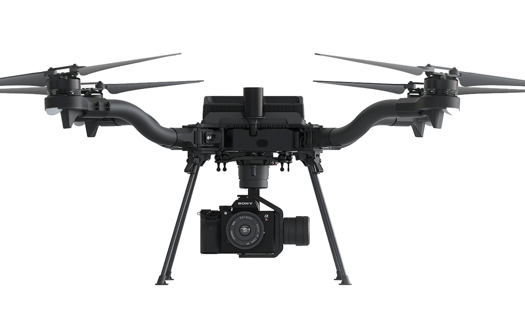
Through an established partnership with Auterion, creator of an open-source drone autopilot operating system, security-conscious U.S. organizations will be able to use Site Scan to plan and execute missions with Auterion’s Freefly Astro drone.
In Europe, data from publicly funded or critical infrastructure projects cannot leave the European Union (EU). For these organizations, a new and fully independent instance of Site Scan for ArcGIS has been deployed to a server cluster in Ireland, ensuring that organizational data resides within the region.
Site Scan for ArcGIS is used by organizations that require drone imagery for visual inspections, site monitoring, asset management and situational awareness. It’s an all-in-one, cloud-based drone mapping solution for managing fleets and collecting, processing, analyzing, and sharing data products. Industries using this solution include architecture, engineering, construction, natural resources, infrastructure and government.
Freefly Astro uses U.S. Department of Defense-approved Blue sUAS software architecture from Auterion, and is fully supported by Site Scan. The first vehicle integrates the software with the Freefly Astro, with more vehicles becoming available.
Auterion’s secure, integrated workflow for mapping uses the Freefly Astro drone, Sony A7R4 camera and Esri Site Scan within a single platform.
The Freefly Astro and Site Scan integration will be available by December. The European deployment of Site Scan is available now.
By David Zilkoski, contributing editor, survey scene
David B. Zilkoski
I attended The Ohio State University (OSU) to obtain my graduate degree in Geodetic Science in 1979. Therefore, I will admit that I am a little biased — once a geodesist, always a geodesist. The basic definition of geodesy is the applied science for determining the size and shape of the Earth, designing and realizing reference frames, and determining where you (and anything else) is on the Earth.
In OSU’s geodesy heyday (1960–1990s), many Americans trained were sent by federal agencies: National Geospatial-Intelligence Agency (NGA), NOAA/National Geodetic Survey (NGS), USGS, Army, Navy and Air Force. During the 1970s, NGS was sending two employees back to school every year. These agencies needed geodesists because they were undertaking major projects such as NGS’ to readjust the U.S. national horizontal (NAD83) and vertical geodetic (NAVD88) networks.
I was one of the employees that NGS sent to OSU to be trained to support the NAD83 and NAVD88.
The advancements in satellites and computers have enabled geodesy to expand into many different disciplines. Geodetic science and technology now underpin many sciences, large areas of engineering (such as driverless vehicles and drones), navigation, precision agriculture, smart cities and location-based services. Geodesy is actually more important than ever.
Today, the environment is different. U.S. federal agencies still need geodesists for developing enhanced and refined geodetic models and tools. However, major U.S. companies, such as Google and FedEx, as well as the automobile industry, precision farming companies and mining companies also need more accurate geodetic models, tools and algorithms. Therefore, these companies also need trained geodesists to perform important research on topics that address their specific geodetic requirements.
Today, OSU’s Geodesy Department is training very few American citizens. As the U.S. moves toward achieving geodetic-grade positioning in real-time in support of new applications such as driverless vehicles and drones, the number of trained geodesists should be increasing, not decreasing [Note: In 1990, there were 92 geodetic science graduate students. In 2019, there were 25; only three were U.S. citizens]. OSU and other universities need to educate and train the next generation of the nation’s scientific workforce of highly skilled research geodetic scientists that will expand industry’s research expertise.
The shortage of American geodesists poses a significant economic risk for the U.S. Europe and China train many more geodesists than the US. There are very few geodetic science programs in the U.S. today, and education in geodetic proficiencies has been fragmented. The OSU graduate program is one of few surviving geodetic science programs.
Users of geodetic products and services need to support geodetic departments in universities so that U.S. geodesy programs can grow to meet the geospatial demands of the future. The geospatial component of the economy is worth about $500 billion/year. So why are we allowing its foundational discipline to shrink in this country?
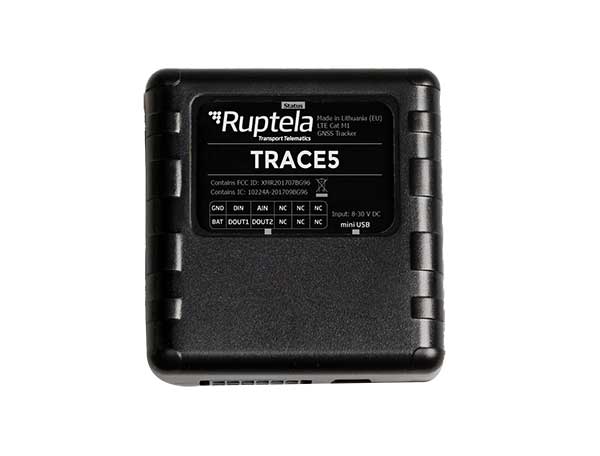
Fast-growing European transport telematics company Ruptela has expanded its global presence to the United States with a tailored ready-to-use telematics solution, the Trace 5 GPS tracker and multifunctional fleet management platform TrustTrack.
The Trace 5 plug-and-play GPS-based automatic vehicle location (AVL) tracker has LTE Cat M1 (4G) connectivity and an integrated battery. It is fully certified according to North American requirements and has a two-year warranty.
TrustTrack is an advanced telematics platform that helps businesses manage their transport resources more efficiently. It connects dispatchers and drivers and enables real-time monitoring and drivers’ management. It also generates trip reports.
To create the North American solutions, Ruptela’s research and development team analyzed the needs of prospective clients and ran product tests on various roads in the United States.
Andrius Rupsys, founder and CEO of Ruptela, calls the release of a telematics solution tailored to the U.S. market a significant milestone in the further expansion of the company. “We are entering the U.S. market confident about our solution for businesses eager to improve their efficiency, whether these are delivery, service fleets, vehicle leasing and financing (BHPH) or car rental companies.
“As a customer-centric company, we always seek to reduce our clients’ efforts by accelerating ease of use, prediction and automation. We believe that with the right measures, less effort can lead to more growth,” Rupsys said.
“Beyond that, our goal is to provide clients with solutions to the issues they are not even aware of yet. To do so, we offer the full solution including hardware and software manufactured and developed in the European Union, which is completed by cellular connectivity and the highest European quality support valued by Ruptela’s clients across the globe,” Rupsys said.
Ruptela also offers individual onboarding (covering software and hardware) and free technical support, which ensures that clients can start using the product instantly. Depending on the expressed need, their manufactured hardware can be bought separately.
For a limited time, first-time users are entitled to a special offer saving them software activation fee and gifting valuable extras.
Around the world, countries are cautiously beginning to reopen businesses and activities they had shut down to limit the spread of the coronavirus.
Countries
Austria will reopen some smaller shops, hardware and garden stores but people will have to wear masks to supermarkets and on public transport. From May 1, all stores, shopping centers and hairdressers will open; restaurants and hotels will open from mid-May at the earliest.
China has largely removed restrictions on mobility while tightening policy to contain the virus transmission of asymptomatic cases.
The Czech Republic on April 6 allowed shops such as hardware and bicycle stores to re-open. Outdoor sports facilities have also reopened. Starting on April 20, students will begin a phased return to colleges and schools, but high schools are not expected to fully open until September 1. From June 8, all retail stores, including those in shopping centers, all restaurants, hotels and other accommodation will be allowed to reopen.
Denmark will reopen daycares, kindergartens and schools (up to 5th grade) on April 22, while other bans, such as on gatherings of more than 10 people, will remain in place until May 10. Churches, cinemas and shopping centers will remain closed. All festivals and large gatherings are banned until August.
Germany will allow stores with a sales area of less than 800m2 to reopen on April 20 if they maintain hygiene and prevent lines from forming. Schools with hygiene plans in place will gradually reopen from May 4, with priority given to primary and secondary pupils in final years, while daycare centers will remain shut. Other social distancing measures, along with bans on large public events, will remain in place.
India has extended what is currently the world’s biggest lockdown through May 3.
Italy allowed bookstores, laundries, stationery stores and children’s clothing stores to reopen on April 14. “Phase 2” of the three-phase reopening plan will start sometime after May 3. Businesses that reopen will be required to make hand sanitizer available, enforce the use of masks in enclosed spaces, and use disposable gloves to handle food and drink.
Japan has tightened its approach, declaring a state of emergency in Tokyo, Yokohama and Osaka, the country’s three biggest cities.
Norway is prioritizing reopening schools and will begin to scale back its lockdown measures from April 20, when kindergartens will start to reopen. A week later, schools will reopen for pupils in grades one to four.
Spain allowed many non-essential employees to return to work after the Easter weekend. Construction and other industries have been allowed to restart, but non-essential stores, bars, and restaurants remain closed. Spanish police are distributing more than 10 million masks to commuters at metro, bus, and train stations.
Switzerland has extended social distancing restrictions to April 26, but might relax other measures later this month, including border controls, school closures and bans on gatherings, if the virus’ spread is kept in check.
United States reopenings vary by state
If you cannot resist the urge to eat at a restaurant or have a drink at a bar during this pandemic without leaving the United States, head for South Dakota, the only state that has not banned these activities except for take-out.
However, unless you live in neighboring Iowa, Nebraska, or North Dakota, you will be most likely breaking the law of one of the 39 states that have banned travel that is not deemed essential or to get to work (five of them with exceptions or limitations). South Dakota and Arkansas have no travel bans and the remaining six states have a variety of advisories and bans targeted at various classes of people, such as those over 70 years old.
As for gatherings, 27 states restrict them to ten people or fewer, four states to nine people or fewer, and five states allow no gatherings at all. Only two states, North Dakota and Minnesota, have not banned any gatherings.
Twenty-five states have limited all nonessential businesses to minimum operations or remote work, three have closed all nonessential businesses, and only two states — again, Nebraska and South Dakota — have not restricted any business activity.
Finally, while 27 states have no state-wide quarantines, the remaining 23 have a bewildering array of quarantine rules for travelers depending on where they have been. However, the duration of the quarantine is always 14 days.
Sapcorda Services GmbH has released its SAPA (Safe And Precise Augmentation) Premium GNSS positioning service.
The SAPA service enables mass-market GNSS devices to operate with increased accuracy and reliability across Europe and the continental United States. The service’s technology unlocks advanced performance with instantaneous sub-decimeter position accuracy for devices used in all market applications.
SAPA is delivered using the open industry-recognized SPARTN format, which allows efficiently delivery of the correction data via internet and satellite broadcast. “When using our service, users across Europe and the United States can experience homogeneous, gap-free, advanced positioning performance with any GNSS hardware designed for high precision positioning,” CTO Rodrigo Leandro said.
The SAPA service is tailored for mass-market applications including innovative mobility solutions, IoT applications, and traditional markets such as maritime.
SAPA was designed from ground up to support safety-critical applications such as autonomous driving.
SPARTN (Safe Position Augmentation for Real-Time Navigation) is a high-accuracy, open- and free-to-use GNSS format tailored for broadcast distribution in mass-market applications.
Sapcorda Services GmbH is a GNSS service provider focusing on the emerging high-precision GNSS mass markets. The company has designed its technology and service offering to serve high volume automotive, industrial and consumer markets.
The funding enables continuation of a national effort by state government geospatial information officers and coordinators to work with other state agencies, local elections officials and state elections offices, national GIS (geographic information system) and elections organizations, and federal partners to identify opportunities to leverage this powerful technology to strengthen elections management and citizen engagement.
“As an organization made up of GIS leaders in state government, NSGIC is uniquely positioned to leverage the innovative work of states to use GIS for elections data,” said Molly Schar, NSGIC executive director. “We have enlisted those innovators to contribute and advise throughout the project. Collaboration has been key to the success of the project. Relationships built in the first phase of the project will be invaluable to the work of the second phase as the project seeks to increase engagement and, ultimately, impact.”
Two more years. The Geo-Enabled Elections project was launched in October 2017 and will now continue for an additional two years. The project aims to help strengthen electoral systems by supporting states in the adoption of GIS.
In practical terms, this means encouraging state governments to replace non-spatial address-file systems with election precinct and voter data in a GIS format, leveraging that format’s inherent visual and analytical advantages.
With its second phase, the project turns to focus on working hands-on with up to 10 more states through the pilot program, developing a curriculum for elections officials on foundations of GIS in elections, increasing awareness of the benefits of geo-enabling elections systems among elections stakeholders, and developing policy guidance and advocacy tools to support integration of GIS in elections.
“Accurate boundary lines and efficient voter placement are the building blocks of our elections and are tantamount to the integrity of the democratic process,” said Tammy Patrick, senior advisor at Democracy Fund Voice. “Democracy Fund Voice is a proud sponsor of efforts such as NSGIC Geo-Enabled Elections as a way to further ensure that the American electorate is well served.”
A report of the work done in the first phase of the project is now available.
Accomplishments in the first two years include:
developing an inventory of state implementations of GIS-based elections systems
giving workshops and presentations at national conferences
publishing detailed reports sharing the state of GIS in elections from the perspective of election officials and state GIS leaders
five pilot and case studies
development of a best-practices guide (both in detail and brief versions) was developed
Also, an inaugural Elections GeoSummit in August convened stakeholders from the national, state, and local levels to discuss best practices for geo-enabling elections in the United States.
These documents and other important resources can be found in a PDF format on the NSGIC website.
Aerial imagery business Nearmap has launched its new 3D product to streamline the way industries such as urban planning, architecture, construction, government and councils view and shape cities across Australia and the U.S.
The company is also previewing its groundbreaking artificial intelligence (AI) technology at its customer event Navig8.
Nearmap 3D allows customers to stream and export 3D imagery on demand at massive scale through its proprietary MapBrowser web application. Because the imagery is updated frequently, businesses can work with the most current information to make more informed decisions.
Nearmap’s new AI technology is turning millions of aerial images — captured over a decade and multiple times a year — into valuable datasets. The datasets can be used to more accurately and efficiently measure change and quantify attributes, such as solar panels, pools, roofs or construction sites.
Organizations ranging from small businesses to large companies and cities will be able to take advantage of AI-driven location intelligence.
“Product innovation is in our DNA. Everything we do has the customer at the core,” said Tony Agresta, executive vice president of product at Nearmap. “Our customers’ worlds are evolving every day. We need to keep innovating to continue to give our customers a competitive advantage through technology breakthroughs like the ones we are sharing today at Navig8.
“Nearmap 3D is the result of a significant investment in R&D, but also listening to our customers and what they need to transform the way they work,” Agresta said. “Accessing 3D imagery up to now has typically been an arduous, time-consuming and expensive process — but not anymore. This represents the single largest, most frequently updated footprint of 3D accessible through a browser. The ability to measure in 3D space, size up an area and then export Nearmap 3D for use in other platforms will transform the aerial imagery market.
“The AI technology that we’re working on will allow organizations to identify locations with specific attributes and in so doing, reduce site visits, generate more leads, and eliminate the time involved to inspect properties manually. Nearmap AI does the heavy lifting so you don’t have to,” Agresta said.
Composite aerial image of Perth, Australia. (Image: Nearmap)
Instant access to 3D through MapBrowser
Nearmap is making 3D imagery accessible to anyone, in the same way it has with 2-D. While Nearmap has offered 3D imagery since 2017, this new iteration of the technology allows users to instantly stream 3D content at massive scale via its MapBrowser web application.
The lightweight platform offers customers an immersive 3D experience, allowing them to visualize cities in 3D from any direction, measure distances, and immediately export a custom area in a variety of 3D formats at unprecedented speed — the download time is a matter of minutes for most requirements and only a few hours for very large footprints.
“It’s like switching from DVDs to streaming services,” said Tom Celinski, executive vice president of technology and engineering at Nearmap. “Our camera technologies have been capturing 3D since 2017, but now our secret sauce is bringing it onto MapBrowser, allowing users to easily and instantly stream this content with many export options. Now users can visualize, measure, define a custom area, export our 3D and use it in their workflows with other commercial platforms and tools. We’re helping 3D experts and novices alike access reality like never before, and this is an important next step in our Reality as a Service journey.”
Nearmap 3D comes with an extensive library, covering more than 400,000 square kilometers. It is updated once a year and covers major urban areas in Australia and the U.S.
“We live in a 3D world, we think in 3D, and so we have to ensure that our products give the closest representation of reality as possible,” Celinski said. “That means businesses that rely on visualizing 3D content, like architects, for example, can now access up-to-date 3D models instantly and export them in just minutes. In a tender process, for example, that can be the difference between winning a new project or not. The opportunities for Nearmap 3D are endless.”
3D image of Manhattan. (Photo: Nearmap)
A living data set
Nearmap AI technology is the result of more than two years’ worth of research and development, and a team of close to 20 data scientists and machine learning engineers. The team, led by Dr. Michael Bewley, is using the petabytes of imagery that the business has captured over the past 10 years and turning it into a living dataset to accurately identify changes or quantify attributes from the Nearmap library of aerial imagery.
Nearmap has built highly accurate machine learning models and deployed them on a massive scale. The automated process, and the constantly learning engine, means that the AI technology can be applied to any new geography. Nearmap also applies the models to new surveys, generating fresh results with current imagery.
To date, Nearmap has performed analysis on over 1 million square kilometers of imagery across Australia and the U.S. (which constitutes about 80 million properties) and is performing more analysis every day. Nearmap is now inviting customers to take part in a beta program to experiment with various use cases.
“We don’t prescribe how our technologies or content can be used by our customers,” said Michael Bewley, director of AI systems at Nearmap. “Our solar customers could use the AI technology to easily identify where and when solar panels have been installed for maintenance jobs, to prospect new clients in an area where solar energy’s popularity is on the rise; or a government entity that previously had the arduous task of tracking swimming pools or construction in their jurisdictions will be able to do it automatically.”
“But this is the tip of the iceberg — we’re just getting started. This technology is going to profoundly change the way that cities are built,” Bewley said. “Our plans include delivering AI results in many forms, much the same way we deliver our imagery today.”
Both technologies will be presented at Nearmap’s flagship event, Navig8, in Perth on June 6, Melbourne on June 11 and Sydney on June 13.
GIS software company Caliper has released new highway exit data for the United States and Canada.
Users of Maptitude 2018 with the Canada or United States country packages can download a free point layer containing all signed and numbered highway exits within their respective country.
The highway exits layer allows users to find the nearest highway interchange to a particular location or determine proximity to a desired interchange. Applications include site location assessment, commercial real estate, franchise development and accessibility studies.
The data can also be used in conjunction with the free U.S. traffic count data to determine traffic volumes around a chosen exit.
The Highway Exits and Interchanges layer can be added to any Maptitude 2018 map.
The report examines the objectives behind Beijing’s decision to develop the system as an alternative to GPS, its efforts to build an industry around the system, and the effects this might have in security, economic and diplomatic terms for the U.S.
“The system’s primary purpose is to end China’s military reliance on GPS, although China’s associated industrial policies will likely affect U.S. firms operating in China’s market. Industry professionals assess there are no inherent risks to products such as smartphones receiving data from BeiDou.”
China’s BeiDou is projected to achieve global coverage by 2020.
The commission was created through a congressional mandate in October 2000, and is responsible for monitoring and investigating national security and trade issues between the United States and People’s Republic of China.
Beidou constellation
Key Findings
China has sought to field its own satellite navigation system in order to (1) address national security requirements by ending military reliance on GPS; (2) build a commercial downstream satellite navigation industry to take advantage of the quickly expanding market; and (3) achieve domestic and international prestige by fielding one of only four such systems yet developed, cementing China’s status as a leading space power and opening the door to international cooperation opportunities.
Industry professionals assess there are no inherent risks to products such as smartphones receiving data from Beidou. While concerns have been raised that malware in devices could allow China’s government to track users, experts (1) are not aware of ways to feasibly transmit malware through a navigation signal and (2) assess that manufacturers will be unlikely to include Beidou’s unique messaging function due to cost factors. Restrictions on technology purchases from China by U.S. government and military users can help guard against malware being physically installed.
Beidou is of foremost importance in allowing China’s military to employ precision-guided conventional strike weapons—a central feature of Beijing’s efforts to counter a U.S. intervention in a potential contingency—if access to GPS is denied.
GPS and Beidou signals are both provided for free and are not in “competition” for market share. Also, the satellite navigation industry is trending toward “multi-constellation” receivers that work with all systems. This means that the U.S. firms that currently dominate the downstream satellite navigation industry will likely be able to incorporate Beidou functionality and continue to compete, although prospects in the China market may narrow.
China plans to expand Beidou coverage to most of the countries covered in its “One Belt, One Road” initiative by 2018, indicating it sees the system as playing a role in its economic diplomacy efforts. China has also sought to incentivize countries in Southeast Asia and the Middle East to begin using Beidou, and seeks to build a network of ground stations throughout Asia to improve the system’s accuracy.
In response to these developments, the United States can consider allowing government and military users to take advantage of multi-constellation devices, while continuing to monitor the industry to assure that security threats do not materialize; promote interoperability to ensure its firms remain competitive; and continue to invest in maintaining its leadership in space.
Current coverage of BeiDou constellation (from report).