Tag: University of Nevada

  • Research Roundup: GPS reveals volcanic activity under Europe

    Research Roundup: GPS reveals volcanic activity under Europe

    Scientists have discovered new evidence for active volcanism next door to some of the most densely populated areas of Europe. The study crowdsourced GPS monitoring data from antennae across western Europe to track subtle movements in the Earth’s surface, thought to be caused by a rising subsurface mantle plume.

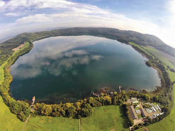
    The Eifel region lies roughly between the cities of Aachen, Trier and Koblenz, in west-central Germany. It is home to many ancient volcanic features, including the circular lakes known as maars. Maars are the remnants of violent volcanic eruptions, such as the one that created Laacher See, the largest lake in the area. The explosion that created the lake is thought to have occurred around 13,000 years ago.

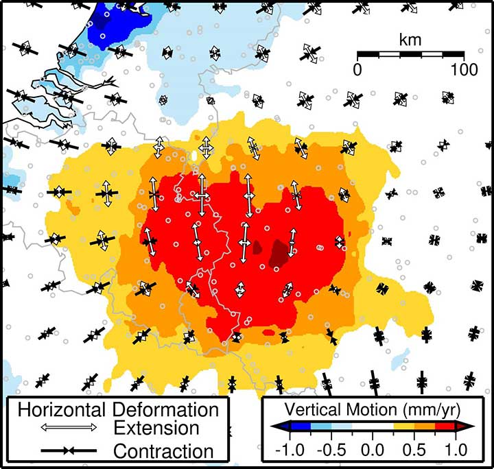
    The mantle plume that fed this ancient activity is thought to still be present, extending up to 400 kilometers (km) into the earth. However, whether or not it is still active is unknown. “Most scientists had assumed that volcanic activity in the Eifel was a thing of the past,” said Corné Kreemer, lead author of the new study. “But connecting the dots, it seems clear that something is brewing underneath the heart of northwest Europe.”

    An aerial view of Laacher See, a volcanic caldera lake with a diameter of 2 km in Rhineland-Palatinate, Germany. Created by volcanic activity, maars like this are also found in other parts of Europe and on other continents, but Eifel-Maars are the classic example worldwide. (Photo: bbsferrari/iStock / Getty Images Plus/Getty Images)
    An aerial view of Laacher See, a volcanic caldera lake with a diameter of 2 km in Rhineland-Palatinate, Germany. Created by volcanic activity, maars like this are also found in other parts of Europe and on other continents, but Eifel-Maars are the classic example worldwide. (Photo: bbsferrari/iStock / Getty Images Plus/Getty Images)

    In the new study, the team — based at the University of Nevada, Reno and the University of California, Los Angeles — used data from thousands of commercial and state-owned GPS stations all over western Europe. The research revealed that the region’s land surface is moving upward and outward over a large area centered on the Eifel, and including Luxembourg, eastern Belgium and the southernmost province of the Netherlands, Limburg.

    “The Eifel area is the only region in the study where the ground motion appeared significantly greater than expected,” said Kreemer. “The results indicate that a rising plume could explain the observed patterns and rate of ground movement.”

    The new results complement those of a previous study in Geophysical Journal International that found seismic evidence of magma moving underneath the Laacher See. Both studies point towards the Eifel being an active volcanic system.

    The implication of this study is that there may not only be an increased volcanic risk, but also a long-term seismic risk in this part of Europe. The researchers urge caution, however. “This does not mean that an explosion or earthquake is imminent, or even possible again in this area. We and other scientists plan to continue monitoring the area using a variety of geophysical and geochemical techniques, to better understand and quantify any potential risks.”

    GPS observations of ground movement under the Eifel area. Colors represent contoured vertical motion inferred from GPS station data, and white and black arrows indicate the direction in which the crust is horizontally stretching or compressing, respectively. The highest upward motion of ~1 mm per year is found near the Eifel volcanic field. (Image: Study authors)
    GPS observations of ground movement under the Eifel area. Colors represent contoured vertical motion inferred from GPS station data, and white and black arrows indicate the direction in which the crust is horizontally stretching or compressing, respectively. The highest upward motion of ~1 mm per year is found near the Eifel volcanic field. (Image: Study authors)

    Citation: “Geodetic evidence for a buoyant mantle plume beneath the Eifel volcanic area, NW Europe” by Corné Kreemer, Geoffrey Blewitt, Paul M. Davis. Geophysical Journal International, Volume 222, Issue 2, Aug. 1, 2020, pp. 1316–1332, https://doi.org/10.1093/gji/ggaa227

  • Seen & Heard: Speed traps and rescuing koalas

    Seen & Heard: Speed traps and rescuing koalas

    “Seen & Heard” is a monthly feature of GPS World magazine, traveling the world to capture interesting and unusual news stories involving the GNSS/PNT industry. 


    Photo: Drazen Zigic/iStock/Getty Images/Getty Images Plus
    Photo: Drazen Zigic/iStock/Getty Images/Getty Images Plus

    Where’s the Beef?

    A new mapping app is helping Los Angeles County residents find more than 2,000 food resources, during and after the COVID-19 pandemic. Sponsored by the non-profit 211 LA County, the LA FoodFinder is powered by Slingshot Earth, which aggregates food resources and service data from multiple public and private sources. The app enables residents to find resources for child nutrition, meal services, groceries/food pantries, senior food needs and government food benefits programs. Since the COVID-19 outbreak, 211 LA County has experienced a 10-fold increase in website traffic for food needs.


    Photo: Symbiont/iStock/Getty Images Plus
    Photo: Symbiont/iStock/Getty Images Plus

    Use that app in Germany? No Waze!

    The German government has amended its road traffic regulations to outlaw apps that alert drivers to speed cameras. The law makes it clear that any app used for traffic-monitoring alerts is forbidden, whether it runs on a phone, tablet or a GPS navigation system. Violating the traffic laws and using speed camera apps inside a car could result in a fine of up to €75 (about $83). Both Garmin and TomTom have emailed registered users alerting them to the news.


    Photo: Geoffrey Blewitt/Debra Vigil
    Photo: Geoffrey Blewitt/Debra Vigil

    Making the most of GPS data

    University of Nevada 2020 Outstanding Researcher Geoffrey Blewitt has made the most of GPS data to study changes in Earth’s crust, from the Ice Age to today. Nevada Today outlines his significant discoveries, including that GPS data may hold a key to detecting dark matter. Other discoveries: Nevada is the fastest growing state, geologically speaking, as it spreads apart. Drought in the western U.S. is causing the Sierra Nevada to lift, and the melting of ice sheets in Greenland is changing the shape of Earth.


    Photo: iStock/Getty Images Plus/Getty Images
    Photo: iStock/Getty Images Plus/Getty Images

    Koala care

    Drones equipped with FLIR thermal-imaging cameras helped save koalas injured in this summer’s Australia bushfires. In a search-and-rescue operation, Victoria wildlife experts and police used DJI Mavic 2 Enterprise Dual drones to scan the forest for injured koalas, many found clinging to scorched eucalyptus trees. The images were relayed to a ground station in a nearby van for closer inspection. When a koala was located, the experts stepped in to assess the animal, and if needed, provide healthcare and relocate it. The team used cherry pickers to retrieve the little animals.