Lockheed Martin Corporation demonstrates its Indago UAS at Unmanned Systems 2015, held May 4-7 in Atlanta. The Indago payload system features a quick disconnect adapter which allows the operator to choose the appropriate payload for the mission, according to Lockheed Martin. The payloads are available for a variety of different applications, including agricultural, mapping, inspection and ISR.
Tag: Unmanned Systems 2015
-
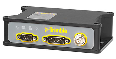
Trimble’s New OEM Module Combines GNSS with MEMS Inertial
Trimble BD935-INS module. Trimble has introduced the Trimble BD935-INS module that features precision GNSS with an integrated 3-D Micro-Electro-Mechanical Systems (MEMS) inertial sensor package. As part of Trimble’s GNSS OEM portfolio, the new compact module augments real-time precise positioning with 3-D orientation.
The BD935-INS module’s simple connectivity and configuration capabilities allow system integrators and OEMs to easily add GNSS and attitude to specialized or custom hardware solutions, Trimble said in a news release.
Trimble made the announcement at AUVSI’s Unmanned Systems 2015 Conference and Exhibition.
“The OEM and system integrator communities demand high performance, reliability and support for their positioning solutions,” said Dale Hermann, general manager of Trimble’s Integrated Technologies Division. “The Trimble BD935-INS delivers the latest GNSS and inertial technology in an easy-to-integrate form factor for demanding conditions and applications such as lightweight robotic or unmanned vehicles. With the BD935-INS module, customers are purchasing a robust navigation solution, extending performance beyond that of a GNSS receiver only.”
Taking advantage of Trimble’s expertise in both GNSS and inertial technologies, the Trimble BD935-INS module has been designed for applications requiring both RTK and orientation in a compact package. By integrating inertial sensors onto the GNSS module, users can experience more robust performance in a variety of challenging environments, Trimble said.
The BD935-INS features triple frequency for both GPS and GLONASS constellations, as well as dual frequency for BeiDou and Galileo. The module delivers fast and reliable RTK initialization for 1–2 centimeter positioning. For applications that do not require centimeter accuracy, the BD935-INS integrated GNSS-inertial engine delivers high-accuracy GNSS and DGNSS positions in challenging environments such as urban canyons, tunnels, heavy canopy or other GNSS-denied environments, the company said.
Trimble also announced the new BX935-INS, which is an environmentally rugged enclosure for OEM or system-level integration. The BX935-INS houses the Trimble BD935-INS module for easy installation and immediate access to high-rate position and attitude data for a variety of applications.
The Trimble BD935-INS and BX935-INS is expected to be available in the third quarter of 2015 through Trimble’s Integrated Technologies Precision GNSS sales channel.
-

AUVSI Announces Rebrand of Annual Trade Show
Annual Conference Renamed Xponential to Reflect Innovative and Expanding Industry
The Association for Unmanned Vehicle Systems International (AUVSI) today announced the rebranding and evolution of its premier global industry event for unmanned systems, drones and robotics, the AUVSI Unmanned Systems show, taking place this week in Atlanta, Ga. With nearly 600 exhibitors and 8,000 attendees, AUVSI’s event attracts leaders in all aspects of the industry, from manufacturers to end users.
GPS World is covering the AUVSI Unmanned Systems show this week from Atlanta. See our coverage here.
“Xponential encapsulates the tremendous growth and innovation in the unmanned systems industry, as well as the broad societal benefits of the technology,” said Brian Wynne, president and CEO of AUVSI. “Xponential will help the world understand the potential of this industry by providing a single gathering place where people can see and interact with the technology and systems that will soon become part of our everyday lives.”
Xponential will continue to serve as the experience hub for business and investment for this $48 billion industry, AUVSI said. This technology is already being used by farmers, first responders and firefighters to help save time, save money and save lives.
Over the next few weeks and months, AUVSI will be working to expand the event offerings to bring a new level of community to the growing industry it serves. Many of these new programs were launched this year, including advanced educational tracks and innovative experiences that bring together the industry’s leading experts and organizations.
For more information visit www.xponential.org.
-
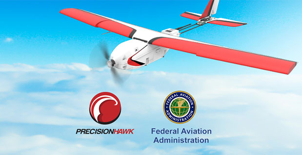
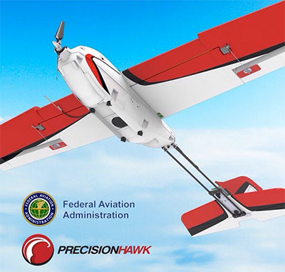
FAA, Industry Partners Launch Pathfinder Program to Define UAV Integration into Airspace
CNN will use Drone Aviation’s tethered drones to gather footage in in urban areas from never-seen-before angles and heights. The company’s WATT-200 was unveiled at the AUVSI this week. Federal Aviation Administration (FAA) Administrator Michael Huerta announced two new initiatives related to unmanned aircraft systems (UAS) today at the Association for Unmanned Vehicle Systems International (AUVSI) Unmanned Systems 2015 conference in Atlanta, Ga.
Pathfinder, the first initiative, announced in the morning, is reported here. The second initiative is an app in development to enable drone hobbyists to fly their craft safety.
Administrator Huerta told the large gathering of national journalists, “The unmanned aircraft industry is changing faster than any segment in the aircraft industry. A new project to harness that energy, the Pathfinder program, is partnering with three leading U.S. companies to expand unmanned aircraft operations in the United States.”
 The FAA is working with industry partners on three focus areas:
- CNN (Cable News Network) will research visual line of sight (LOS) operations for newsgathering in urban areas. CNN will continue working with Georgia Tech University to improve newsgathering for all organizations.
- PrecisionHawk will investigate agricultural operations for rural areas, flying outside LOS.
- BNSF Railway, second-largest freight railroad network in North America, will undertake inspection of rail infrastructure, also beyond visual LOS.
Huerta said that the partners, collectively, “are trying to push the envelope, what can we accommodate, accommodate safely, and what can we learn from that. We’ll test a little, learn a little, then test some more. How do we see a staged implementation? To integrate unmanned aircraft, but to do it safely, as directed by Congress. We’re trying to push the edges of what we can allow, working with partners who have specific uses and resources that they will apply to those.”
When asked for a timeframe to reach new UAV regulations, he replied, “I can’t comment a lot on the rule itself, but it’s fair to say that in the rulemaking comment process [which closed on April 24], we received more than 4,500 comments. It’s too early to say how those comments will shape what the final rulemaking will take. Assessment will be done in the coming months, perhaps by the end of the year, but that’s an aggressive timetable. This effort will go on as long as the partners want us to go on doing it. That’s not accomplished in six months, nor should it take a million years.”
As to LOS restrictions, and beyond LOS, he replied, “The framework of the previously published rule was focused on LOS, and on the use of visual observers in addition to the operator. Now we’re taking the next step, to explore beyond LOS uses. What are reasonable applications for that, and what mitigations for safety should be put in place for that? Everyone wants to get there. It’s important to figure out how we get there safely.”
What mitigations will be put in place for beyond LOS? A vice president of BSNF Railway said that the company is “working with FAA and several vendors around command and control infrastructure. This is yet to be fully defined. The railroad is a very safe an unforgiving environment. This doesn’t replace anything we’re doing today, it’s an addition.” He defined the operating environment as ” a 300 or 400-mile capability, to fly looking for broken rail, etc., beyond the visual, on-the-ground inspections that rail crews already do. ” He anticiated the use of “sense-and-avoid technology [for the UAVs], not using chase planes but perhaps using communications capabilities from cell towers and railway infrastructure along the right of way.”
The CEO of PrecisionHawk commented similarly, “We’re not changing much of our operational flow, just extending the baseline for it. We will implement a traffic-management technology, called Lattice, leveraging to ensure safety and reliability beyond the operator’s LOS.”
Gregory Agvent, CNN’s director of News Operations, said he looked forward to “some camera shots that were previously impossible for us, that now we’re going to be able to do.” Under the terms of the Certificate of Authorization (COA), Agvent said that “We’re capable of doing it [undertaking UAV missions] without asking for (FAA) permission” for specific flights.
The three industry participants concurred that they will work with their [UAV] partners in parallel with the rules to develop a certification process, so that the FAA can determine their vehicles are uniformly safe, the same way the y do with piloted aircraft currently. Both the railroad and PrecisionHawk have one currently operating flight platform each, and are looking at others, as theirs do not fit all applications.
“These are not exclusive [agreements],” emphasized Huerta, “limited to particular platforms or applications. This is a practical research effort to apply, learn, and integrate on the broadest scale.” When asked about possible further participants in the Pathfinder project, Huerta indicated the three companies represented on the briefing platform with him: “They came to us. You can interpret that as an invitation. We’re casting a very wide net. How do we et to a broader integration and implementation? We need multiple ways to gather information.”
Agvent urged, “It’s critical for manufacturers to come to the table, to get certified by make as opposed to individual models, to get free access to the sky.”
Huerta concluded, “We are learning together, as an industry and as a regulator. How can we collectively, as an industry, learn more in order to see a much more robust integration of unmanned aircraft into our aviation industry? We’re all interested in pushing the boundaries, and sharing the information broadly across the industry.”
The surprise preview of the pending announcement drew scores of curious and concerned industry representatives and exhibitors at the massive AUVSI show, who gathered anxiously outside the press briefing room, to which they were not admitted.
“The FAA is moving ahead with safe integration of UAS into the busiest, most complex airspace in the world,” according to an FAA statement issued prior to the briefing.”Even as the agency proceeds with rulemaking for small UAS, it continues to look at new ways to foster safe UAS operations by both hobbyists and businesses.”
-
Welcome to AUVSI’s Unmanned Systems 2015
The Association for Unmanned Vehicle Systems International’s (AUVSI’s) Unmanned Systems 2015 show, held May 4-7 in Atlanta, convenes the global community of commercial and defense leaders in intelligent robotics, drones and unmanned systems.
-
Avyon Offers Precision Mapping for Microdrones md4 Fleet from Applanix
Avyon, a sUAS (Small Unmanned Aircraft Systems) integrator and distributor, is using the Applanix APX UAV for its md4 fleet, to provide users with cost-effective direct georeferencing technology.
The integration of the Applanix APX-15 UAV on the md4-1000 and md4-3000 microdrones will offer solutions for unmanned aircraft while complying with weight and size restrictions for payloads. The APX-15 works seamlessly with all other airborne sensors such as digital cameras, LIDAR and other sensors, Avy0n said.
The APX-15 on the md4-1000 microdrone is on display at booth 1803 at the AUVSI Unmanned Systems 2015 show, being held May 4-7 in Atlanta, Ga.
“The integration of the APX-15 with md4-1000 and md4-3000 will provide users with a precision mapping capability, minimizing or eliminating the requirement for ground control points and making mapping missions more efficient,” said Mike Hogan, Avyon’s business development manager.
The APX-15 UAV on the md4 fleet will improve aerial mapping by eliminating GCPs (ground control points) for triangulation, as well as reduce the amount of overlap in the surveying process. This will increase efficiency and effectiveness for area flown per mission and the post-mission data processing, Avyon said.
“We recognize the need to provide the growing UAS mapping market with the same highly efficient solutions that we pioneered for airborne mapping over 15 years ago,” said Joe Hutton, director of Inertial Technology and Airborne Products at Applanix Corporation (xyHt pg. 14). “We are now offering a cost-effective solution that meets the size, weight, power and cost requirements of small UAS, and maintains the Applanix pedigree for quality and performance. We are pleased Avyon has partnered with us. The md4-1000 DMS-UAV is a powerful new solution.”
-

Kairos Unveils UGV Tech for Heavy Equipment at AUVSI 2015
Kairos Autonomi produces solutions that can be retrofitted or “strapped-on” to any existing optionally unmanned vehicle or vessel. Kairos Autonomi is displaying its latest autonomous technology designed for use with heavy equipment and machinery. Kairos’ robotic applique kits are add-on vehicle autonomy systems that provide unmanned capabilities to current manned vehicles, rendering them optionally unmanned.
Equipped with larger gear faces, stronger actuators than its predecessors and a pathing upgrade, the Pronto4 Heavy delivers the increased torque needed to control the traction, braking, throttle and implements in heavy vehicles and equipment, as well as smarter robotic functions such as GPS path following and supervised autonomous behaviors.

The Pronto4 Heavy Planar Robotic Applique Kit For Heavy Equipment. (PRNewsFoto/Kairos Autonomi) The robotic applique kit is platform independent, meaning it can be installed in any heavy vehicle or machine, rendering that vehicle optionally unmanned, which means the equipment can still operate manually as needed.
Kairos Autonomi is exhibiting at the AUVSI Unmanned Systems 2015 show being held May 4-7 in Atlanta, Ga. (booth #1437).
The Pronto4 Robotic Applique Kit manufactured by Kairos is used throughout the world to convert existing man-operable ground vehicles and surface vessels into unmanned systems. Applications include government or academic research and development; military training and test and evaluation; range clearance; mining; and tactical military applications.
-
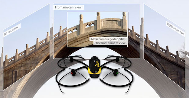
SenseFly Launches Intelligent Mapping and Inspection Drone

Swiss professional drone maker senseFly has launched the eXom, its new quadcopter UAS for mapping and inspection. The eXom is available to pre-order immediately and ships this summer.
SenseFly made the announcement at the AUVSI Unmanned Systems 2015 show being held May 4-7 in Atlanta, Ga. (Hall B2, Booth 519).
The eXom is a sensor-rich system, sensefly said. Developed by experts working across numerous fields of robotics, this lightweight quadcopter offers professionals such as civil engineers and land surveyors the situational awareness, imaging flexibility and durability they need to complete challenging tasks safely, accurately and efficiently.
“We believe the eXom’s level of application-focused technology is unique in the civilian drone market,” said Antoine Beyeler, CTO and co-founder of senseFly. “This platform tightly integrates several one-of-a-kind features, such as TripleView imaging, advanced situational awareness and full flight mode flexibility — to provide inspection and mapping professionals with the functionality they desire from a rotary system.”
eXom is a future-ready platform with a quad-core computer onboard, senseFly said. Like senseFly’s fixed-wing drones, it offers users evolving performance through regular software updates, adding the latest drone tech innovations to keep the eXom at the cutting edge for years to come, the company said.
eXom’s low take-off weight of 1.7 kg (3.7 lb) ensures its users will, in many countries, have less flight authorization paperwork to deal with than those who use heavier systems.
The eXom’s advanced integrated sensors work together to provide the user with full situational awareness and support obstacle avoidance:
- Five navcam vision sensors allow the operator to see in the direction the drone is moving, automatically via its flight control software, without needing to turn the system’s TripleView camera head. This technology is similar to the visual parking sensors in modern cars, but brought into a 3D flight environment.
- Five ultrasonic proximity sensors work in harmony with eXom’s navcams to ensure the operator always knows the drone’s distance from nearby objects. (The drone’s shock-absorbent carbon fibre shrouding is also always on hand to protect its rotors in case of surface contact.)
- Numerous other sensors, including inertial measurement units, barometers, magnetometers, GPS and magnetic encoders, maximize the drone’s stability and safety.
eXom’s autopilot-controlled TripleView camera head enables the user to view and record three different types of imagery during a single flight without needing to land to change cameras:
- HD video
- Ultra high-resolution stills
- Thermal still/video
Because the TripleView head faces forwards, eXom can fly up close to target structures such as building walls and dams to achieve sub-millimeter data resolutions. Plus, with the head’s 270-degree vertical field of view, users can document objects positioned directly above and below the drone — crucial for tasks such as bridge and roof inspections.
eXom offers various flight modes:
- Autonomous mode — for mapping projects. First, create a flight plan using eMotion X’s mission blocks. eXom then launches, flies, acquires geo-referenced imagery and lands itself.
- Interactive ScreenFly mode — this streaming video mode is for live inspection tasks. Use the supplied joypad to navigate and orient the drone via computer screen. This mode includes flight assistance features such as cruise control and distance lock.
- Create a flight plan, launch in autonomous mode, then go live on demand.
- No matter which mode is activated, RC-based manual control always remains available as a backup function and for experienced pilots.
Full technical specifications can be downloaded on this PDF.
Visit senseFly at Unmanned Systems 2015: Hall B2, Booth 519. The eXom will be demonstrated in flight at the senseFly booth at at the show’s Air & Ground Demo Area (demo timings: May 6, 12:15 and 14:15, May 7, 11:45 and 14:15).
-
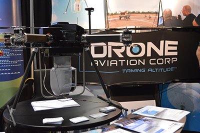
Drone Aviation to Provide Imaging, Surveillance Aerial System for Defense

The Drone Aviation WASP system. Drone Aviation Holding Corp., a developer of specialized lighter-than-air aerostats and tethered drones, today announced that its wholly owned subsidiary, Drone Aviation Corp. (DAC), has received an order from specialized defense contractor Troll Systems for a set of Winch Aerostat Small Platform (WASP) aerostat systems.
Drone Aviation is exhibiting at the AUVSI Unmanned Systems 2015 show, being held May 4-7 in Atlanta (booth #550).
Under terms of the award, DAC and Troll will jointly form a working group to integrate the L-3 Wescam MX-10 advanced optical sensor system into the WASP platform for an international customer. The working group plans on commencing integration in May with initial flight testing expected to take place by Q3 2015.
Drone Aviation also announced that CNN is working with the company to explore how their tethered drone technology might be used in newsgathering operations in urban areas, as part of its FAA partnership, also announced at the AUVSI show. CNN selected Drone Aviation to leverage its WATT-200 tethered drones to gather footage from never-seen-before angles and heights. WATT-200 was unveiled at the AUVSI this week.
DAC develops and manufactures the WATT Electric Tethered Drone, Blimp in a Box (BiB) and WASP aerostat product lines. The WATT Tethered Drone, as well as the BiB and WASP aerostats, utilize a secure, high strength tether line that remains connected to the ground for safe and reliable operations.
DAC’s systems are intended to provide semi-persistent, mobile intelligence, surveillance, and reconnaissance (“ISR”) and extended communications for various applications. Each system can provide low cost, mobile ISR and mobile communications for days, weeks or months. BiB and WASP aerostats are currently in use in a number of U.S. Department of Defense (DoD) applications as well as at State and Local Police and Departments of Transportation where they provide silent, cost effective day and night monitoring and mobile communications.

Drone Aviation is exhibiting this week at AUVSI Unmanned Systems 2015 in Atlanta. DoD-owned WASP systems are currently participating in sponsored exercises and are part of future capability studies as part of the DoD’s evaluation of the WASP as a highly mobile, tactical aerostat for ISR and communications. The DoD-owned WASP systems have successfully completed operations in a series of the United States Army Network Integration Experiments (NIEs) and have been recognized by the Army as a tactical battlefield solution that can support soldiers on the ground.
“Drone Aviation is pleased to partner with Troll Systems to expand the capabilities of our WASP platform and to help them meet the stringent requirements of their overseas customers,” said Felicia Hess, CEO of Drone Aviation Holding Corp. “With the addition of the L-3 Wescam MX-10 optical package, we are greatly expanding the operational capabilities of the WASP tethered aerostat system, further demonstrating the platform’s ability to flexibly deliver simple, secure and cost effective tactical surveillance and communications to customers.”
-
Exelis Showcases CorvusEye 1500 Analytics at Unmanned Systems 2015
Exelis has improved the way its CorvusEye 1500 wide-area airborne system processes and analyzes the vast amount of data it collects, which is crucial in helping customers make critical decisions, the company said.
CorvusEye 1500 is one of the programs Exelis is featuring at Association for Unmanned Vehicle Systems International’s (AUVSI’s) Unmanned Systems 2015 May 4-8 in Atlanta (booth #2449). From an altitude of 15,000 feet, CorvusEye 1500 provides color and infrared imagery of a city-sized area unavailable with comparable airborne systems. At Unmanned Systems 2015, visitors will see how users work with the real-time analytics and processed data to search for vehicle tracks based on location and time.
“It’s all about context,” said Dwight Greenlee, director, regional persistent surveillance, Exelis Geospatial Systems. “Conventional video surveillance systems with their ‘soda straw’ views can miss critical activities, making it hard to understand what’s happening over a wide area. CorvusEye now has real-time analytics that automate certain tasks. For example, users can set ‘watch boxes’ or ‘trip wires’ in as many as 10 areas of interest. Users are then alerted if anything moves in or out of that area, and they can automatically track that moving object. Because of the context provided by CorvusEye, users can be more confident in the data to make decisions.”
Another new capability in CorvusEye is the ability to cue a second sensor, such as a hyperspectral sensor, to scan a location for certain spectral “signatures” indicating the presence of a material or gas. Analysts also can easily integrate full-motion video sensors into the cueing capability.
Processing CorvusEye data post-flight provides analysts with a database of all moving objects in the entire scene, allowing them to gather critical forensic intelligence and enabling a better understanding of behaviors and patterns across the region.
At 15 inches in diameter and weighing less than 95 pounds, the CorvusEye turret and sensor package can fit on most midsize unmanned and manned aircraft and uses standard interfaces to swap into virtually any 15-inch airframe mounting location. CorvusEye is exportable to many military, intelligence and security customers around the world, Exelis said.
-

Live from AUVSI’s Unmanned Systems 2015
The GPS World staff is reporting live from Unmanned Systems 2015, held May 4-7 in Atlanta. The event convenes the global community of commercial and defense leaders in intelligent robotics, drones and unmanned systems, hosted by AUVSI.
 Check back throughout the week for event updates, including news, photos, videos, tweets and more.
NEWS
Trimble Expands UAS Portfolio with Mutlirotor Partnership (5/7)
Geodetics Teams with Velodyne for Real-Time Mobile Mapping Systems (5/7)
Trimble’s New OEM Module Combines GNSS with MEMS Inertial (5/6)
FAA, Industry Partners Launch Pathfinder Program to Define UAV Integration into Airspace (5/6)
Model Plane Fliers to Get Real-Time, Location-Based Flight Safety Info (5/6)
AUVSI Announces Rebrand of Annual Trade Show (5/6)
Avyon Offers Precision Mapping for Microdrones md4 Fleet from Applanix (5/5)
Kairos Unveils UGV Tech for Heavy Equipment at AUVSI 2015 (5/5)
Drone Aviation to Provide Imaging, Surveillance Aerial System for Defense (5/5)
SenseFly Launches Intelligent Mapping and Inspection Drone (5/5)
Exelis Showcases CorvusEye 1500 Analytics at Unmanned Systems 2015 (5/5)
CEA Research: UAS Could Reach 1M U.S. Flights a Day in 20 Years (5/5)
Septentrio Launches UAS Receiver, Software for Drone Market (5/4)
VectorNav Unveils Updates to VN-300 GPS/INS at AUVSI Show (4/30)
AUVSI Unmanned Systems Offers Demonstrations, Exhibits (4/15)
FAA Grants 30 More Commercial UAS Exemptions (4/8)
Xsens Adds Active Heading Stabilization to IMU (4/1)
VIDEO PLAYLIST
PHOTOS

Stampede Presentation Products product line includes DJI, AEE, Walkera and xFold.
Kairos Autonomi produces solutions that can be retrofitted or “strapped-on” to any existing optionally unmanned vehicle or vessel. 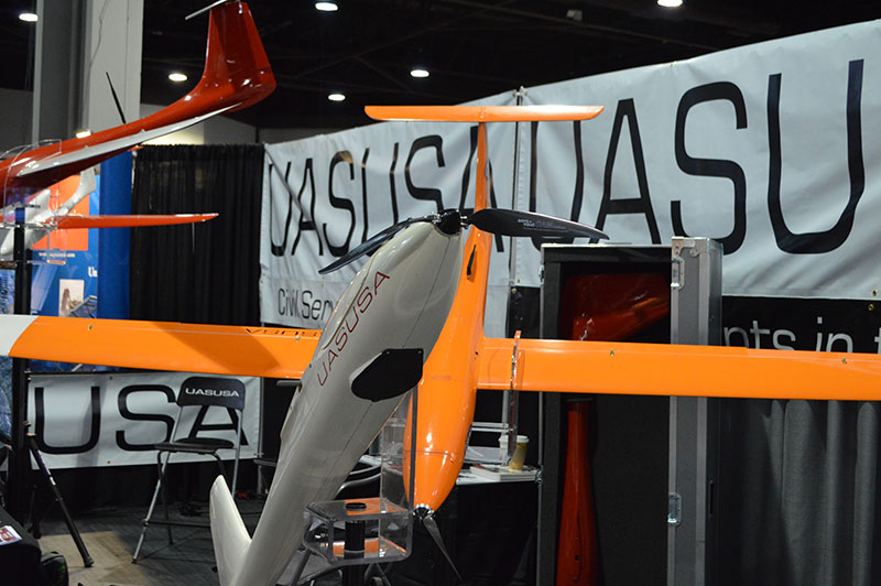
UASUSA develops UAS for the civil market. Other markets include agriculture, surveying, education/research, and emergency response. 
Amimon introduced CONNEX, a high-performance wireless HD video link for multirotor drone platforms. 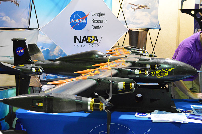
NASA’s Langley Research Center showcased its GL-10 UAS at Unmanned Systems 2015. 
Brian Markwalter, senior vice president, market research and standards, CEA, shared the association’s domestic UAS economic analysis. 
What is the future of unmanned systems? 
Lockheed Martin gave a flight demonstration of its Indago UAS. TWEETS
A quick look at the @LockheedMartin Indago UAS flight demo at #Unmanned15. Full version to be on the website soon! pic.twitter.com/6TCt0gn9gs
— GPS World (@GPSWorld) May 6, 2015
What is the future of unmanned systems? #unmanned15 #XponentialEvents pic.twitter.com/Ia5PP1Q7Ye
— GPS World (@GPSWorld) May 6, 2015
-
Welcome to AUVSI’s Unmanned Systems 2015
The Association for Unmanned Vehicle Systems International’s (AUVSI’s) Unmanned Systems 2015 show, held May 4-7 in Atlanta, convenes the global community of commercial and defense leaders in intelligent robotics, drones and unmanned systems.