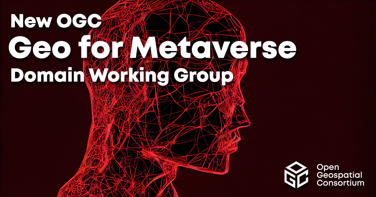
The Open Geospatial Consortium (OGC) has formed the Geo for Metaverse Domain Working Group (DWG), which will serve as a forum for the collective geospatial expertise of the OGC community to gather to help build and expand the open Metaverse. The group is open to both OGC members and non-members.
The group plans to contribute its expertise in 3D, modeling and simulation, artificial intelligence, digital twins, streaming, augmented and virtual realities, routing, mapping and more — all at scale.
The group will work on pieces of the Metaverse that pertain to geospatial applications and standards by identifying standardization activities and best practices based on FAIR (making data Findable, Accessible, Interoperable and Reusable) data principles.
The DWG will be the primary point of contact with the Metaverse Standards Forum, of which OGC is a founding and principal member.
3D geospatially anchored data is powering innovation across a range of industries. This same data — relied upon for construction of the real world — is now driving the creation of virtual/digital worlds that will form parts of the Metaverse.
The surveying profession has experienced a plethora of advancing technology over the past two decades and it does not look like there will be a slowdown any time soon. From robotic total stations to laser scanning to the use of multiple GNSS constellations, the profession is constantly adapting these emerging technologies into a useful tool for daily applications. For most practicing surveyors, it is a challenge to keep up with not just the hardware of these advancements, but also with software, which is being developed in parallel. Have you tried to open and draw a simple figure in any of the industry standard CAD programs lately?
The complexity of these programs, while advancing the capability of many technical professions, forces even the casual user to maintain a regular habit of software education and training. While it may seem primitive to say that a practitioner is a “practicing” surveyor, on-the-job training never stops. Just when the profession thinks there are no more significant advancements, something comes out of left field that truly blindsides us. (See the adoption of UAVS by the surveying profession compared to the public sector…) What do I think will be one of the next “big things” to revolutionize surveying? The technology is already here, and we need to seriously get on board with adoption before we miss another opportunity to highlight the expertise of the profession.
VIRTUAL REALITY and AUGMENTED REALITY (VR & AR)
First, we need to know that virtual reality (VR) and augmented reality (AR) are different, even though many people use these terms interchangeably. The differences are as follows:
Virtual Reality (VR)
VR is a virtual world generated by computers and programming.
VR is a closed environment that is fully immersive.
VR requires a device (specialized glasses and/or a headset).
Users in the VR experience are limited by the programming and their computer’s abilities.
The VR experience may be based upon real-world conditions but is a fictional setting.
Users of VR can travel and experience conditions in real and fictitious places.
VR can allow users to have experiences that are not physically possible in the real world.
VR is 75% virtual + 25% real (industry “rule of thumb”)
Augmented Reality (AR)
AR is typically based on actual physical places.
AR is an open environment that is partly immersive.
In AR, the user controls the environment.
AR combines virtual elements and experiences with real world conditions.
Experiences in AR can be accessed by computer, tablet, and smartphones.
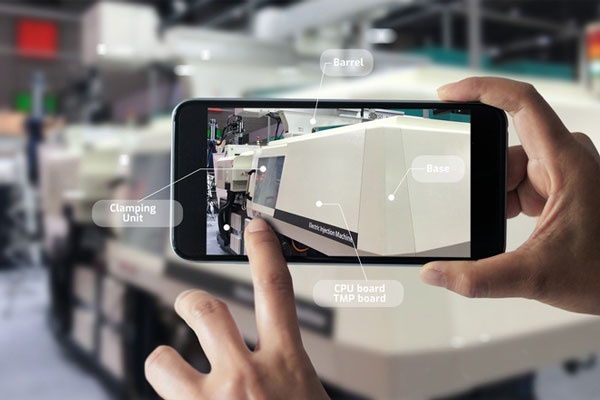
AR is useful for product visualization and evaluation.
AR is 75% real + 25% virtual (industry “rule of thumb”)
It is important to know these difference between the two technologies in order to implement the correct one for the task at hand. However, both will play an important in surveying for generations to come.
One of the surveyor’s biggest responsibilities is to complete an accurate site conditions model by topographic methods. Once the topographic survey is completed, site designers will utilize this information to create a unique project that works with the existing site conditions. Advances in CAD software and technology allow engineers and architects to design in 3D and blend the new site with the existing conditions, drainage, and utilities. These designs can be further refined into virtual reality models to give the project’s stakeholders a better indication of what the final product will be when construction is completed.
The key takeaway here is that the surveyor is responsible for delivering the existing conditions model. A model that accurately represents the subject site but in digital form enables the design of the project to be more efficient and realistic to meet the client’s expectation. Surveyers, however, will not use virtual reality as much as augmented reality, for many good reasons.
USES OF AUGMENTED REALITY TECHNOLOGY FOR SURVEYING
AR is still in its infancy. Because surveyors have an interest in the existing and proposed conditions of sites, the use of AR becomes an important tool for the future. Merging proposed information with existing site conditions can become the norm, but like many emerging technologies, the profession will need to learn how to embrace it.
To get a better idea of how the technology works and why surveyors need to consider using it, let us look at an application that showcases AR: Pokémon Go. Yes, the smartphone game app that took the world by storm in 2016 and captivated many “trainers” to search the streets for Ultra Balls and characters. (There are still more than 100 million active players worldwide.) Players of all ages have continued to search for elusive items and characters in a high-tech scavenger hunt that is constantly changing, and all based upon the real world around us. By merging a real-time view with game entities at random geographic locations, players move about our world using one of the best examples of AR.
How does this apply to the surveying profession? Surveyors could utilize AR in everyday tasks but that would require having a fully developed 3D design model that could merge with the existing conditions in their visual device. There are a variety of devices for utilizing AR, including smartphones and tablets. Many of the new data collectors running Windows and Android operating systems can also be used for incorporating AR into the field operation. Here are some examples of AR how can be utilized for surveying tasks:
While construction staking, AR can be used to assist with structure and improvement location. A quick visual check can help confirm staking calculations are consistent with engineering design.
Use AR to visually check installed improvements, including curbs, utility structures, and paving. Any deviation from the proposed design should be quite evident.
When establishing property corners, AR will help the field crew quickly determine whether the calculated location is accessible. This can be used for staking out pre-calculated boundary points and/or proposed lot corners in a new subdivision.
Here are a few ideas as to how surveyors could utilize AR in everyday tasks in the future:
As public utilities are becoming more available within GIS shape files with geographic locations, they could be utilized with AR to help visually establish locations in the field. Mainline utilities and service lines would become easier to physically verify using AR.
Another GIS shapefile entity, the parcel line layer, could be used to help the surveyor understand where the property owner believes the line(s) to be as opposed to the actual monumented location.
All reference monuments and benchmarks established by public agencies using geographic location information could enhance the “treasure hunt” of confirming local datum points.
SURVEYING USING AR TO PROTECT THE PUBLIC
Geospatial information has revolutionized our world, so using AR to help when trouble strikes can potentially be a lifesaver. Recently, an oceanfront condominium in Florida collapsed due to structural failure. While the age of the structure precluded it from having any digital geographic location data, any new similar development could be measured and recorded to assist with future emergency needs. Almost all new development has digital surveying, engineering, and architecture and must use local horizontal and vertical datums. Using the proposed information and verifying with post-construction record drawings, the digital record can be created.
It doesn’t take a design flaw to create a public hazard. For instance, a gas leak could render any building, such as the Florida condo, susceptible to catastrophic damage. By having a digital model of the underground structure, emergency crews could use AR to help locate potential open spaces in the building. As is the case with installing fire suppression systems and emergency exits, the cost to create a digital model of a completed building will be well worth it to save lives.
Underground utility corridors within cities, campuses, or manufacturing facilities could also utilize geospatial locations to establish a digital map for future use with AR. It will take time and significant cost to map existing facilities, yet it should be required for new sites to provide this information for emergencies and for use when designing expansions within the site. Having this utility information to use with AR during the design phase could lead to identifying potential problems before construction starts.
Haiti after an earthquake. (Photo: 1001nights/E+/Getty Images)
Another reason to plan for future safety is how much uncertainty we face in today’s society. At press time, we are coming up on the 20th anniversary of 9/11. We also just watched Haiti suffer another devastating earthquake. The 2021 hurricane season has also been very active, so that danger looms large, too. Disasters happen all the time with little to no warning. Our world is much more advanced than we were at the turn of the century, so we can use these advancements to map our infrastructure. Let us hope we never need to use the digital information for another disaster akin of 9/11. Instead, let us use it to ensure that we can get to someone in a remote spot if necessary.
THE ROAD TO FUTURE MAPPING AND AUTOMATION
As previously discussed, establishing a digital twin of our world could help provide a better map for establishing parcel ownership, reducing construction conflicts, and offering better planning tools for future expansion. Will it be completed within my lifetime? No, and I doubt it will be done within the next couple of generations after me.
We can, however, get a significant start on capturing the necessary information to begin the process of digitization. Technology has exceeded my expectations just within the past decade, so I can only hope that more advancements will help with building this digital beast. More architects and engineers are utilizing BIM (building information modeling) for 3D design and collaboration. Most municipalities and counties have built some form of GIS that uses one of the standard geographic datums. Surveyors have fully embraced GNSS technology so state plane and national geographic coordinate systems have become the norm. In addition, we are seeing a wide number of consultants use autonomous vehicles (aerial, hydro, and terrestrial) with photogrammetry, LiDAR, and SLAM remote sensing. Another bit of good news is that computing power is higher than ever and that storage space is cheap for all this data. We should also include how 5G has expanded our reach and, with cloud storage, we can work from just about anywhere. We can do so much more than most of us ever dreamed of, so we need to leverage that into creating a digital entity that can be helpful.
Photo: RyanJLane/E+/Getty Images
HOW TO IMPLEMENT THE LATEST TECHNOLOGY
Augmented reality is one of many new technologies surveyors need to introduce into their toolbox. Many of you may be asking where to begin; my answer, depending on your age, may offend you.
Hire a Gen Zer. Really.
As a Gen Xer, I have come to realize my limitations on technology and being able to fully implement it. The Z generation, while lacking the experience of us wily old guys, see things much differently. The smartphone/tablet/computer, and even the latest data collectors, are designed with them in mind. They grew up playing computer games based in virtual reality, developed excellent hand-eye coordination, and find efficient ways of getting things done. Our surveying world is almost completely digital (when is the last time a client only wanted paper copies of a plat?), so now is the time to make the leap and ditch the drafting table. We have as much to learn from them as they do from us. Together, we can get the surveying profession ready for the next generations. It has been a great profession for us, so let us hand it off to the Z generation. They will (eventually) be glad we did.
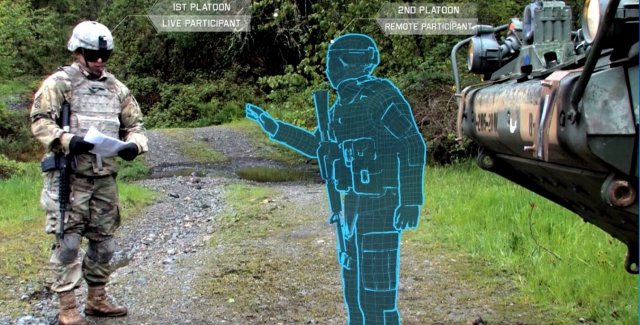
The U.S. Army considers virtual reality training as an important path ahead to prepare warfighters.
The U.S. Army awarded Bohemia Interactive Simulations (BISim) a major extension to demonstrate technologies for a cloud-enabled, virtual world training capability.
BISim is a global developer of advanced military training and simulation software.
The contract award helps meet the requirements of the Army’s Synthetic Training Environment (STE) initiative. STE aims to converge virtual, constructive and gaming training environments into a single unified architecture.
The ambitious STE project will enable simulation systems Army-wide to leverage a persistent virtual world for any imaginable training need, including support for multi-domain operations incorporating cyber and space.
Central to STE is a cloud-enabled One World Terrain (OWT) that will let warfighters conduct virtual training and complex simulations anywhere on a virtual representation of the Earth. OWT will leverage cloud technologies to deliver to the point of need, ensuring a common and high-fidelity whole-Earth terrain representation for a multitude of different simulation systems.
The Synthetic Training Environment will assess Soldiers in enhancing decision-making skills through an immersive environment. (Photo: U.S. Army)
“The U.S. Army’s vision for STE marks a monumental change in how they acquire, develop and deliver new simulation and virtual training technologies to soldiers,” said Pete Morrison, BISim’s co-CEO and chief product officer. “We’re honored to be selected to assist the Army in developing innovative solutions that will shape the future of how virtual training is used to enhance operational readiness.”
BISim has been developing its next generation of simulation technologies since 2014. The new technology suite includes a cutting-edge, military-specific whole-earth game engine, deterministic AI, an efficient geospatial terrain server and component-based development technology.
BISim technology underpins funded research and development for One World Terrain. Additionally, BISim recently demonstrated Reconfigurable Virtual Collective Trainer (RCVT) prototypes for STE. The latest OTA extension is a significant ramp up in the breadth and ambition of the technology being demonstrated.
BISim’s STE offering includes four core technologies uniquely suited to meeting future military simulation requirements (including U.S. Army requirements).
VBS Blue. A high-performance, whole-planet data ingestion and rendering engine with a very high level of procedural detail, designed to ingest any conceivable terrain data format as well as source data directly. VBS Blue will support networked (cloud) terrain paging and geo-specific insets as well as the latest graphics technologies. It provides photorealistic detail, and includes a massive vegetation library representing every region on Earth. The technology is highly applicable across all types of image generation and is optimized for many AR/VR applications.
STEWS. A geospatial data server that provides efficient networked access to the various data sources required for rendering applications. STEWS provides a curated database of terrain data layers that can be streamed into any STE-connected client application at run time (including non-BISim applications). Any application connected to STEWS can stream high fidelity terrain data in a performant manner. Both new and legacy terrain formats are supported through new STEWS plug-ins.
VBS Control. High fidelity, doctrinal and deterministic entity-level artificial intelligence that is uniquely suited to operation on whole-earth terrain. VBS Control runtime offers highly efficient real-time path planning that allows AI to move seamlessly through open, urban and interior spaces. The VBS Control Editor allows powerful new AI behaviors to be developed at both the individual entity level and at higher levels of command for land, sea and air assets.
Gears. A software development framework that defines a standard way for components to communicate through formal interfaces. Gears uses a component-based architecture to promote rapid development by building applications from self-contained systems and having them communicate via formally defined interfaces. This allows functionality to be reused and avoids the complexity of tightly coupled systems. See www.gears.studio for more information.
The Army also selected BISim for a five-year contract to support their Games for Training Program and BISim’s technology is being rolled out on CCTT (the U.S. Army’s largest ground simulator training program).
This e-newsletter marks the sun setting on the career of GeoIntelligence Insider columnist and contributing editor Art Kalinski, long active in geospatial circles. Art is handing the journalistic reins to William Tewelow, a former intelligence specialist with the U.S. Navy. He also served a special assignment at the U.S. Department of Transportation and is currently a manager with the U.S. Federal Aviation Administration (FAA). The following discussion muses about the direction of our geospatial tradecraft in the coming years.
Tewelow’s Geointelligence column will alternate monthly with Mike Jones’ Defense PNT column. Every issue of this newsletter also brings you the latest news on both expanding fronts, hardware and software, in the defense and security realm.
Passing the torch
A conversation between retiring GeoIntelligence editor Art Kalinski, GISP, and his successor, William Tewelow, GISP.
Counter-drone technology research and operation efforts are helping to prepare for the potential threat of drone swarms. This Lockheed Martin concept is explored in “Technology That Counters Drone Swarms.” (Image: Lockheed Martin)
Art: A factor of life is that you just can’t predict with certainty where technology is headed or what the issues will be. Several weeks ago I attended a UAV (unmanned aerial vehicle) users group that seemed like a glimpse of the Wild West. I thought the key discussion topics would be the latest technology which seems to change almost weekly. That was not the case. The key discussions were the same as the early days of GIS: legal liability, jurisdictions, data ownership, administrative issues and so on, as the FAA changes the rules and regulations. I began to see that there will be more employment opportunities for lawyers than techies and pilots.
Although most of the attendees at the conference were geospatial/first responder users, I’ve learned of a growing community of non-traditional users such as power line inspectors and even tower painters. Yes, a tower painting company using tethered UAVs to paint in dangerous locations such as bridges, tanks and towers. At first I thought that would be difficult but by using a tethered system, heavy batteries are eliminated and bigger UAVs will permit heavier hoses, etc. Although the FAA had little interest in tethered balloons and UAVs, that could change as the size, altitude and potential crash radius expands.
This is just one example of how our technology is moving in many unplanned directions, everything from UAVs with new ways of collecting imagery to more exotic topics such as artificial intelligence, machine learning, augmented reality, virtual reality (VR) and gamification. The entire trade craft is evolving in ways I don’t think anybody could have predicted just a few years ago, much less a decade ago. It will be interesting to see where it goes.
William: You mentioned several new technologies mixing things up. Small sats are also making a significant impact. They are game changers. Imagine the traditional 2D satellite imagery base map. With the tech we have now 3D base maps are possible and have been for a long time with DEMS. Now, small sat imagery can be overlaid atop the 3D basemaps providing fresh imagery with periodicities of 24 hours or less, including multi-spectral. I’ve even seen small sat video overlays. That’s game changing.
Art: Not only small sats but the work being done with drone swarms is an exciting new area. If data needs to be collected in a hostile area or if flight clearance in a busy air corridor was limited, a swarm of maybe 100 drones could capture a wide swath of data at high resolutions, with multiple spectrums in very short order.
Virtual reality and augmented reality are two areas which have always intrigued me and they are coming to fruition. When I started out in GIS, I told people working for me to do the best we could building our regional database because at some point we would have construction workers wearing goggles that will augment the reality of what they are seeing with GIS data. That day is here and people are finally starting to do that. So, the entire concept of AR (augmented reality) and VR I find extremely exciting.
William: Yes, absolutely, in fact I believe they used drone swarms in the hostage situation in Algiers in 2014. And you are right. VR and AR use for first responders is especially critical. Say you’re a disaster relief person at night in a smoke-filled building. Night vision and thermal vision reach a practical limit. However, combining the vision devices with AR you may be able to navigate through the environment well enough. AR shows at least what should be there so accurate and timely data is critical. I can see this is where things are headed. Additionally, more mundane tasks such as design and modifications of structures could be enhanced. Work is already being done using AR and VR to facilitate the design process.
Art: VR started as fun and games but to me serious use VR is where the new and exciting action will be for geospatial practitioners. Virtual trainers I saw recently included small arms and artillery trainers for the military to a less exciting but equally impressive virtual trainer to teach arc welding and even spray painting a car. Significantly more critical was a VR surgical trainer where the muscle learning and hand eye coordination required is significant. It’s obviously quicker, easier and cheaper to practice virtually than on a real human or real equipment and the VR environment is just one short step away from surgical robots operating in remote locations.
William: Right, and you are touching on gamification, where VR can be used to train toward certain results. Take the military, for example, gamification can save all manner of resources – bullets, people, buildings the environment. Additionally, users can also scale up or down. The VR environment doesn’t just mean roads, maps or mountains. You can get down to a micro level.
Art: It’s interesting you mention that. One aha! moment I had years ago was at the first Esri User Conference in San Diego. I went through the map gallery. A lot of examples of different uses for GIS were on display and one person had created a map of the human circulatory system using ArcView Network Analyst. Looking at it I thought, of course, whether its blood vessels or interstate highways, it’s a network; so, this individual was using a geospatial tool to map the entire blood vessel network.
William: We are now in the realm of nano technology, where things are small enough to work on blood cells. Imagine steering straight towards a cancer cell by pinpointing a location in relation to the body.
Art: It’s almost like the movie “Fantastic Voyage” except in a virtual environment.
William: Yes. Being able to put the nano technology right where it needs to be means entering an age of focused medicine so that a pill releasing nano particulates doesn’t impact the whole body just the area needed. That’s another discussion in itself. Of course, all of that will have to be controlled, mapped and understood in terms of what it’s doing and where it’s going in relation to the body.
Art: One area that is very concerning to me is cyber. All of this stuff we’ve talked about is very vulnerable whether stealing data or doing damage to a society. Thwarting those threats is getting into machine learning, AI and other topics bordering science fiction.
William: Yes, and you are getting into artificial intelligence. IBM, Google, Amazon, Facebook, Microsoft and our three letter agencies are all investing into the world of Geospatial AI. I am not sure where GeoAI will end up but we can already see some hints. The amount of geospatial data is overwhelming and imagine the explosion happening with IoT. How will all that be managed? GeoAI will do pattern recognition so in effect GeoAI is assisted intelligence.
As an example let’s consider a high profile event. There are 1000’s of parameters that need to be tracked such as surveillance cameras, social media feeds, a suite of sensors, etc. Identifying critical patterns is crucial so Geospatial Assisted Intelligence can monitor the parameters of the event then notify the analyst when a triggering event occurs. That’s where the technology is going where it has to go.
Art: One has to have a truly dizzying intellect to keep track of all aspects of our technology. At the last NGA (National Geospatial-Intelligence Agency) conference, Director Cardillo talked extensively about open systems and open sources which are growing directions for the agency. I believe it’s good to get away from everything being “inside the tent” and taking advantage of the extensive capability in the broad geospatial community. The stated goal is to be able to develop needed geospatial tools, in an unclassified environment, not in months or weeks but literally in minutes to provide those tools to analysts in the field. Things have come so far from the day I was just happy to get a pen plotter to print a simple map.
William: It really is mind boggling. I was there when full motion video began and that was dynamic 2D imagery but then it made the jump to 3D dynamic imagery and my circuits fried. I still have a hard time comprehending all the data crunching that goes into it and it is now almost standard. The future is amazing. That is the direction I want to continue to explore.
Esri has released a virtual reality (VR) solution for CityEngine, the company’s 3D modeling software.
The newest version of CityEngine allows urban planners, architects and GIS professionals to simply and quickly create VR experiences on mobile devices, the company says in a news release. These experiences can be viewed in the free ArcGIS 360 VR app from Esri Labs. Users can immerse themselves into 3D scenes by teleporting to static viewpoints and comparing different urban planning scenarios.
“We are pleased to see Esri add a mobile VR solution to its 3D smart city platform,” says Christian Huerzeler, project manager at the department of urban planning in Zurich. “By using ArcGIS 360 VR, our planning board and jurors can now study the impact of new architectural developments and urban planning scenarios from the perspective of pedestrians and citizens.”
Now, rather than relying on high-performance graphics computers and cumbersome wired VR accessories, having a simple smartphone paired with an affordable wireless headset is all that is required to be immersed in a VR experience.
“We greatly simplified the creation and sharing of the mobile VR experience,” says Dominik Tarolli, head of 3D geodesign at Esri. “In a matter of minutes, a CityEngine user can now create a VR experience out of a 3D scene and share it in ArcGIS Online, Esri’s cloud solution.”
CityEngine comes with many new additional features, including an OpenStreetMap-ready rule set, says Esri, who is offering a 30-day free trial.
Most of you are familiar with hackathons, but this one was focused on geospatial solutions for first responders with NGA’s GeoQ as a foundation. The goal was to hack unclassified geospatial datasets and open-source tools to build effective solutions for disaster response and recovery.
The foundation – NGA’s GeoQ
Ray Bauer, who heads up the NGA GeoQ effort, was the keynote speaker. He explained how GeoQ meets the goals set by former NGA Director Latisha Long and current Director Robert Cardillo to take advantage of open-source data, applications and most important talent. Ray explained how the growing complexity of the GEOINT world forces NGA to take advantage of every geospatial resource available while keeping their classified work secure.
Ray stated NGA’s hackathon goals, specifically:
“We are interested in working with participants to identify and create new, interactive and efficient ways of reading, disseminating and analyzing tons of data from disparate systems. We highly encourage leveraging open-source tools and other software solutions participants bring to the table. This hackathon is not just for those entrenched in the geo world! We’re interested in everything from new mapping interfaces, mobile solutions, lightweight and portable information dashboards, hardware integrations with commercial off-the-shelf tools like sensors and UAVs, and everything in between!
“The intent of this event is to think outside the box and employ new tools and alternative open-source data to more efficiently and accurately send the most relevant data to emergency responders quickly. Currently there are dozens of data sets that make it difficult to quickly search and integrate into a common operational environment, particularly across the sectors: firefighter, police, hospital, dispatcher, HEMSI, air evacuation, utilities, Department of Transportation, etc. How do we share information among these groups during disaster situations such as tornadoes, hurricanes, shootings, flooding, significant traffic events, chemical spills and other potentially catastrophic events?”
For those of you not familiar with GeoQ, there is an excellent overview produced by NGA that is on Youtube.
GeoHuntsville hackathon goals
The pre-event announcements listed the following goal.
Combine commercial and proprietary hardware and software solutions to create unique concepts/solutions. Specifically:
Solve disparate data problems among current open source data sets (i.e. overlaying multiple shape files with real-time data from multiple sources such as emergency responder software, sensors in the field, social media, e.g.).
Recreate more aesthetically appealing user interfaces considering numerous data sets — to include mobile solutions.
Suggest new solutions leveraging a subset of currently available data. (Use the data we give you, use the data you bring, use the data we don’t know about — and create a solution to a problem we don’t know exists.)
Integrate new solutions or disparate data into open source tools, like GeoQ.
Identify ways to more efficiently and accurately receive and analyze updates from the field. (This could be anything from a tool an emergency responder uses or social media resources.)
Come up with a way to disseminate critical information across agencies and geographic locations.
First responder involvement
The aspect of this hackaton that was particularly valuable was the direct involvement of numerous Huntsville first responders. Policemen and firemen were able to explain their difficulties and needs face to face with the programmers and engineers who were participating in the hackathon, so the participants were not operating in a vacuum. See my interview with the Huntsville fire chief.
Fueled with sodas, chips and snacks, the hackers worked overnight to accomplish the goals. At stake were three prizes, including a top prize of $1,000. The prizes were not huge, but they provided some incentive including bragging rights.
Although some results were similar to existing applications, the different approaches were still very impressive for a two-day event. You may find one or two applications worth your further investigation for integration in your systems.
The teams
Mobile Damage Assessment
Micah Cleveland and Larry Wilbourn provided firefighters with a way to directly report the status of damaged structures or casualties and triage via a smartphone.
Situational Awareness
The team of Larry Mason, Tyler Hughes and Michael Carroll built an application displaying real-time locations of all emergency vehicles and the display of preplan floor plans and imagery to show details such as electric and gas cut offs.
Virtual Reality GIS Display
Jason Rade and Jason Nofki demonstrated their system of displaying GIS data and imagery using a virtual reality headset. They indicated that the next step was to display the data as augmented reality.
OpenSensorHub
Steve Jones demonstrated a system to display Internet of Things (IoT) devices as live links on a map to display data, imagery and video from those sources. (Steve participated in the event, but did not enter into the competition.)
WEBEOC data to current devices
Two team members worked a problem proposed by Madison County Emergency Management Agency. They read legacy format WEBEOC data and converted the information into more modern device data structures.
And the winners are…
First Place: Mobile Damage Assessment
Second Place: WEBEOC data to current devices
Third Place: a tie between Situational Awareness and Virtual Reality GIS Display
A few gems developed at the hackathon may be useful with your applications effort. If you need additional information regarding the hackathon and participants, contact Chris Johnson of GeoHuntsville at [email protected].
Virtual reality was huge at MWC, such as this demonstration at the ST Telecom booth. (Photo: Kevin Dennehy)
When more than 50 companies ask for interviews during the Mobile World Congress, which has grown to more than 100,000 attendees, you have to jot down what the product, service or strategy is — and then move on. So, here’s a wrap up of my four days in Barcelona.
BARCELONA, Spain — Location technologies are playing a prominent role in the development of Internet of Things (IoT)-enabled products and services, particularly for connected vehicles, at Mobile World Congress here, held Feb. 28-March 2.
One location company, Glympse, partnered with two major companies, Google and Samsung, for their location sharing products. With Google, Glympse is part of the company’s Project Tango, which provides a mobile device with 3-D motion tracking and depth sensing.
Samsung launched its Galaxy S7 and S7 Edge phones to a packed auditorium of guests and press members. While the phone has an improved camera and battery life, the S7 and S7 Edge also have Glympse’s location-sharing capability for both an installed Car Mode and an app called My Place. “The Google Tango [product] allows a mobile device to know where it is, and our location-aware product allows people to see where their friends are. It’s been a great partnership,” said Bryan Trussell, Glympse founder and CEO.
Indoor location and mobile advertising
The number of mobile advertising and indoor positioning companies at MWC seems to be increasing each year. Most companies involved say the market, which has such big players as Google, Intel and ST Telecom involved, is finally arriving.
Polestar’s Jean Chenebault, COO, said the company has its Bluetooth beacons in hospitals, airports and shopping centers. “We are at Schiphol Airport, Yale Hospital and many others. We have 600 beacons installed at the Mobile World Congress,” he said. “The market for indoor location has really grown.”
At MWC, indoor positioning vendor Indoor Atlas signed a deal with Yahoo! Japan, which is the leading Internet portal in the country with 63 billion page views a month. The company, founded in 2012 with seven employees, uses geomagnetic positions based on the magnetic sensor in a smartphone. The company’s biggest customer, Baidu, is using the magnetic positioning in its maps product, said Indoor Atlas CEO Janne Haverinen.
Another company says its system is complimentary to GPS to deliver latitude, longitude and floor-level altitude in areas the satellite-based system doesn’t work, or works poorly. “We determine positioning, again, where GPS doesn’t work well,” said Christian Gates, NextNav vice president, strategy and development. A bonus point for NextNav is that it doesn’t burn up wireless spectrum, which is expensive, unlike cellular positioning, said Tom Wrappe, NextNav vice president, ecosystem development.
Industry veteran Wrappe was with SnapTrack and went to Qualcomm when that company purchased the assisted-GPS company that helped spur location in cell phones. Gary Parsons, former XM Satellite Radio CEO, heads the company’s board of directors.
A mobile advertising company, xAd, rolled out its MarketPlace Campaign builder that allows companies to control location campaigns. Using real-time location data, MarketPlace shows marketers available visitors and brand location. “Instead of showing an advertiser just impressions and clicks to a website, with the location capability we can show them that a customer went to the store to buy Kentucky Fried Chicken,” said Dipanshu Sharma, xAd co-founder and CEO.
Kevin Dennehy in VR goggles at Samsung press conference.
TCS has new name, showcases products and services at MWC
The acquisition of TeleCommunications Systems by Comtech Telecommunications for an estimated $431 million was completed during MWC. The company will not see personnel reductions, and its operations in Annapolis, Maryland, will continue, said Jay Whitehurst, Comtech president of commercial software group.
The company had several location services at MWC, including its Trusted Location application that provides such organizations as online gaming companies and financial entities a system to identify and prevent fraud using location algorithms. The company, which launched its VirtuMedix product at the 2015 MWC, said it has signed up several doctors for the patient monitoring system.
European fleet market growing
After a slow initial period, the European market for fleet tracking products has seen phenomenal growth, said Edward Kulperger, Geotab vice president, Europe. “We have nearly 500,000 units worldwide, and sell our products through an authorized reseller network,” he said. Geotab, which has a European partnership with Telefonica, offers MyGeotab software for in-vehicle driver coaching, engine diagnostics, real-time GPS vehicle tracing and other functions for the continent’s trucking companies.
Another company, Aeris, has had ups and downs in the past eight years, but has been seeing steady growth recently, said Dan McBride, Aeris senior director of marketing. “We have 7 million connected users through a MVNO-style service provider strategy,” he said. McBride said the company’s IoT products aren’t cookie-cutter in that they are tailored for each project. Currently, the company is pursuing most IoT markets in Europe: fleet, payment, healthcare and network security, to name a few.
Skyhook offers wearables location context
Unlike the Consumer Electronics show (CES), outside of a few new products from Garmin and Mio there wasn’t a big splash at MWC for wearables. However, companies are incorporating location technology on fitness child safety and personal security wearables, said David Bairstow, vice president of product at Skyhook Wireless, which uses GPS, Wi-Fi and cell towers for hybrid positioning.
“Without location you are blind to the user’s surroundings and will be reliant on a paired smartphone to complete your solution,” he said. “The use cases are endless when you pair these devices with location, varying from the ability to save a life, to keeping tabs on your kids, to capturing and adding context to photographic memories in real time. When accuracy is of the utmost importance, precise location can fill the void. The need for location on wearable devices is obvious and opens up a new world of capabilities for the wearable industry that they haven’t had historically.”
Waze finding success in Europe
Another company with a sluggish European start, Waze, is seeing big growth in central Europe, particularly in Italy and France, said Carlos Gomez of Waze. “We are improving the product to tailor it to European driving in city centers,” he said. Part of Google, Waze doesn’t sell any data it collects from users of the crowd-sourced map product. “We don’t sell it and are concerned with companies who sell data to third parties,” Gomez said.
Saying it is the only pure-play navigation company now that HERE is owned by a German automaker consortium, Navmii says its app has been downloaded more than 26 million times in 187 countries. “Many people do not know that Navmii builds its own maps, which it sells to companies around the world,” said Peter Atalla, Navmii founder and CEO. Navmii is also very much in the connected car and autonomous driving space. We are releasing a new version of the app called Navmii AI, which uses computer vision systems to provide ADAS features to drivers.”
Like Waze, Navmii enlists its users, and the data they provide, to contribute to the map to warn the community of upcoming disruptions. “This intelligence enables Navmii to generate high-quality traffic and map data,” Atalla said. “We believe that navigation should be free to users. We make money from the data collected (traffic and mapping) and white-labeling our technologies to power other devices and apps.”
Location critical for connected car payments
Accenture, Intel and Visa collaborated on a product to demonstrate the potential for next-generation connected vehicles. The demonstration showed how it can be securely and temporarily connected to personalized profiles for car sharing services, take advantage of biometric identification technologies and use location-based services (LBS) ecosystems, said Marcello Tamietti, Accenture Mobility Connected Transport lead.
“The proof of concept is integrated with easy-to-use, safe and secure contextual commerce services to transform the car-sharing and driving experience through IoT technologies, whether the vehicle is owned by the driver or not,” he said.
Contextual commerce relies on a payments system being situationally aware, and removing friction from the payments process, Tamietti said. “In this scenario, by applying analytics to data collected from a car on the behavior of a particular driver, services can then be offered through an LBS ecosystem that match a driver’s preference, and then make paying for it [seamless],” he said.
Security issues not going away
As companies roll out products, and differentiation is important, security and data privacy will become a top priority. “Even consumers with little interest or understanding of technology will see news stories about hacked devices and companies, and as a result will look to be reassured about how secure their personal data is, but also how far that data will be ‘legally’ shared with other companies,” Tamietti said. “Recent [Accenture] research found that for nearly half of respondents, security concerns and privacy risks rank among the top three barriers to buying an IoT device or service.”
Creating a secure connected vehicle will involve cooperation among all members of the ecosystem, at every step of the manufacturing process, and throughout the vehicle’s lifecycle, Tamietti said.
Every device connected to a network is a potential source of weakness in a targeted hacking attack, said Kevin Curran, senior member of IEEE and senior lecturer at the University of Ulster. “We might also find, however, that some of the features we are adding to cars, which use a connection such as dialing 911 when a car crashes and an airbag is deployed, with the GPS coordinates leads to lives being saved. We really have to consider the benefits that come from more connected features versus the dangers that may arise to a car vulnerable to remote attacks — which will, of course, happen,” he said.
Timing important for IoT netwoks
LBS and timing information are key enablers for IoT networks and applications. The time, location and velocity accuracy provided by multi-constellation systems provides the fundamental building blocks for numerous IoT applications, said Stephen Douglas, Spirent Communications Solutions and Technical Strategy, IoT. These applications range from simple consumer monitoring devices such as pet trackers through smart-city transportation management solutions to the future of connected cars with autonomous driving controls, he said.
Because of the time-consuming and resource-intensive testing process, sometimes test conditions are unreliable, Douglas said. “With a GNSS signal simulator, you can test your device in any combination of conditions, and repeat the same test conditions over and over again to assess the impact of your modifications,” he said. “Then, when you are confident your device works well in simulated test conditions, you can significantly speed up and lower the cost of field testing by recording the RF signal environment at a test site, and playing it back to the device in the lab.”
In other Mobile World Congress news:
This year’s MWC topped 100,000 attendees for the first time. A show getting that big loses its ability to have people network, which was always the big draw for me over CES. The show had 2,200 exhibits/booths.
The big deal this year at both CES and MWC was virtual reality. Having VR goggles on most of the time at Samsung, and seeing Mark Zuckerberg walk up to announce a partnership with the Korean giant and his giant Facebook social media platform, was surreal. One company, AirPush, is leaning forward to start its own advertising on VR platforms called VirtualSky, said Cameron Peeples, Airpush CMO.
Join Lyft, BMW Group, HERE and 25 other speakers at Driverless, The Business of Autonomous Vehicles, which is March 22-23 at the Crowne Plaza Hotel, San Francisco Airport. Panels feature new technology, executive insights on the future, investments, legal and cyber security and mapping. For more information, go to www.driverlessmarket.com or [email protected].
Topcon Positioning Group has acquired a significant share of holdings a company that assists customers in virtual design and construction (VDC).
Viasys VDC — based in Espoo, Finland — has developed a suite of tools and services to assist customers in building virtual models for infrastructure and site-work projects. Using building information modeling (BIM) technologies, its solutions create VDC models that optimize the construction process throughout the project’s lifecycle, creating enhanced quality, higher efficiencies and reduced costs, Topcon said.
“Viasys VDC solutions allow for the import of virtually any BIM or non-BIM design model, offering seamless interoperability with open design standards currently in the market — which provides the contractor or engineer with full control and visibility of the entire design throughout the entire project,” said Heikki Halttula, CEO and president, Viasys VDC Ltd. “With advanced simulation tools and communication functions, design-build issues can be detected before actual work starts, or at any time during the process.”
Accurate 5D simulation allows for optimal planning and execution, Topcon said in a news release. Other significant features include cloud-based collaboration functions as well as mobile access to models and information on-site.
Topcon currently offers various BIM and remote site management/visibility solutions aimed at many of the markets served by Viasys VDC.
“Now, with our investment in Viasys VDC, we have partnered with the technology leader to allow us to offer an expanded platform for the future generation of advanced Topcon VDC solutions with seamless BIM interoperability for our partners and customers,” said Ewout Korpershoek, Topcon executive vice president for mergers and acquisitions.
“Partnering with Topcon is an exciting step forward to help advance our industry-leading VDC solutions, while also expanding their reach to a global audience,” Halttula said. “With Viasys VDC offices in Finland, California and Vietnam, we are also well positioned geographically to work directly with existing Topcon operations in Europe, North America and Asia.”
In addition to a full suite of BIM-based mobile workforce solutions, Viasys VDC offers an operational asset management solution as a basis for lifetime maintenance of the VDC managed projects.
Bosch Sensortec is unveiling new generations of intelligent accelerometers and high-performance gyroscopes at the 2016 International CES in Las Vegas.
Aimed at smartphones, tablets and wearables, the new devices cover a wide range of requirements, from low-power consumption for always-on applications such as step counting, to high-performance optical image stabilization (OIS).
Intelligent three-axis accelerometers — BMA422 and BMA455
Today’s applications running on modern mobile devices place many demands on motion sensors. These sensors are required to continuously sense motion, such as for step counting operations, while at the same time delivering a high level of performance without compromising battery lifetime.
To meet these challenges, the new sensors from Bosch Sensortec integrate embedded intelligence functionality into standalone accelerometers. Adding intelligent features to an accelerometer enables innovative applications, while minimizing power consumption by eliminating the need to wake up an application processor or an additional discrete sensor hub. Overall system power management and user experience can be improved by the accelerometer detecting and processing motions such as glance, pick-up and tilt.
Current consumption of the new accelerometers is kept very low to extend battery life. The integrated Android 6.0 “Marshmallow” features minimize programming effort for customers. Each device delivers outstanding accelerometer performance for low offset, low temperature coefficient offset (TCO) and low noise levels, the company said.
Two new accelerometers are being launched: the BMA422 “all-rounder” is suitable for standard applications, and the BMA455 provides high performance for gaming and immersive activity tracking. In addition, the high level of performance enables demanding applications covering augmented reality, virtual reality, image stabilization and industrial measurement applications such as spirit leveling and inclination measurement.
High-performance gyroscopes — BMG250 and BMG280
Mobile devices require gyroscopes for many applications, including gaming, augmented reality, virtual reality and OIS. To provide the necessary performance, Bosch Sensortec’s new gyroscopes combine the most important parameters in a single device: low noise, low TCO and high bias stability.
Although delivering high performance, they do both feature the lowest power consumption of any standalone gyroscope in the market, thus helping to extend battery lifetime in mobile devices.
Today’s announcement includes two three-axis gyroscopes: the BMG250 provides low noise, low TCO and high bias stability, while the BMG280 delivers ultra-low noise optimized for OIS and includes a secondary interface for OIS, making it fit for use in camera modules. The BMG280’s secondary interface can be used in parallel with the primary user application interface, for example for simultaneous panorama creation and OIS.
Packages and availability
The new devices are provided in small packages. The BMA422 measures 2.0 x 2.0 x 0.95 mm³, while the BMA455 is 2.0 x 2.0 x 0.65 mm³. The BMG250 and BMG280 gyroscopes both measure 3.0 x 2.5 x 0.83 mm³.
Samples of the all sensors are available now, with mass production of the gyroscopes to commence in Q1 2016 and mass production of the accelerometers starting in mid-2016. For pricing, contact Bosch Sensortec.
zLense, a specialist provider of virtual production platforms to the film, production, broadcast and gaming industries, is offering a depth-mapping camera that captures 3D data and scenery in real-time and adds a 3D layer to the footage. The camera is optimized for broadcasters and film productions.
The technology processes space information, making new and real three-dimensional compositing methods possible, enabling production teams to create 3D effects and use state-of-the-art CGI in live TV or pre-recorded transmissions, with no special studio set up.
With the zLense Virtual Production platform, directors can produce simulated and augmented reality worlds, generating and combining dynamic virtual reality (VR) and augmented (AR) effects in live studio or outside broadcast transmissions. The depth-sensing technology allows for a full 360-degree freedom of camera movement and gives presenters and anchormen greater liberty of performance. Directors can combine dolly, jib arm and handheld shots as presenters move within, interact with and control the virtual environment and, in the near future, using only natural gestures and motions.
“We’re poised to shake up the Virtual Studio world by putting affordable high-quality real-time CGI into the hands of broadcasters,” said Bruno Gyorgy, President of zLense. “This unique world-leading technology changes the face of TV broadcasting as we know it, giving producers and program directors access to CGI tools and techniques that transform the audience viewing experience.”
Doing away with the need for expensive match-moving work, the zLense platform dramatically speeds up the 3D compositing process, making it possible for directors to mix CGI and live action shots in real-time pre-visualization and take the production values of their studio and OB live transmissions to a new level. The solution is quick to install, requires just a single operator, and is operable in almost any studio lighting.
“With minimal expense and no special studio modifications, local and regional TV channels can use this technology to enhance their news and weather graphics programs — unleashing live augmented reality, interactive simulations and visualizations that make the delivery of infographics exciting, enticing and totally immersive for viewers,” he continued.
The zLense Virtual Production platform combines depth-sensing technology and image-processing in a standalone camera rig that captures the 3D scene and camera movement. The matte box sensor unit, which can be mounted on almost any camera rig, removes the need for external tracking devices or markers, while the platform’s built-in rendering engine cuts the cost and complexity of using visual effects in live and pre-recorded TV productions. The zLense Virtual Production platform can be used alongside other, pre-existing, rendering engines, VR systems and tracking technologies.
The VFX real-time capabilities enabled by the platform include:
Volumetric effects
Additional motion and depth blur
Shadows and reflections to create convincing state-of-the-art visual appearances
Dynamic relighting
Realistic 3D distortions
Creation of a fully interactive virtual environment with interactive physical particle simulation
Wide shot and in-depth compositions with full body figures
Facebook has purchased Occulus, a virtual reality gaming startup, for $2 billion. “Today, we’re pleased to announce that we’ve joined forces with Facebook to create the best virtual reality platform in the world,” Occulus announced via a blog post.
“Facebook understands the potential for VR,” the blog said. “Mark [Zuckerberg] and his team share our vision for virtual reality’s potential to transform the way we learn, share, play, and communicate. Facebook is a company that believes that anything is possible with the right group of people, and we couldn’t agree more.”
Occulus demonstrated its most recent version of the Oculus Rift development kit at the Game Developers Conference in San Francisco, March 17-21. Occulus Rift is a virtual reality headset for 3D gaming.
The Oculus Rift DK2 prototype took home the award for Best in Show at January’s Consumer Electronics Show.