South Korea has launched a test operation of a new GPS-based positioning service, reports the Korea Herald. The Gridded Virtual Reference Station (G-VRS) works without an internet connection to provide real-time location data with centimeter-level accuracy.
The G-VRS will complement the current VRS system for users in remote areas with unstable internet connections — islands, mountains or fast-moving vehicles.
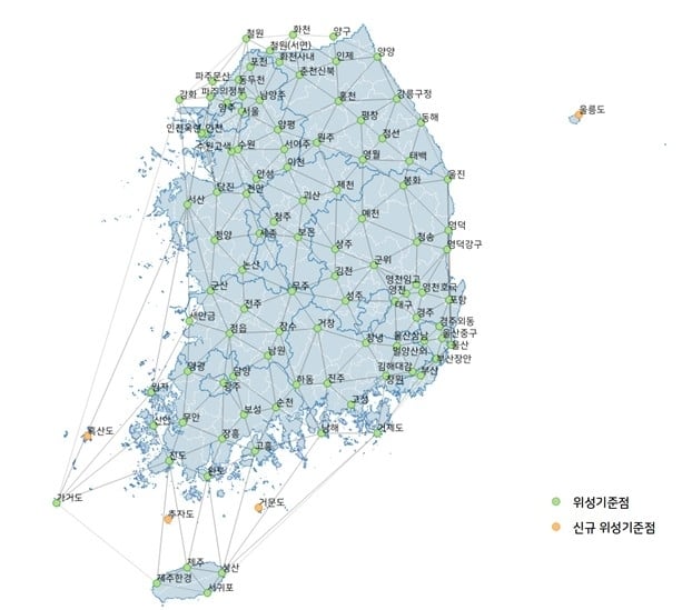
GNSS control points have been installed across the country, including four on Jeju Island and one in Gageodo, an island off the southwestern coast. The state plans to install additional points on four islands, including Ulleungdo, about 120 kilometers off Korea’s eastern coast, to operate 103 control points in total by the end of this year.
BizStation, a database company based in Japan, and u-blox have announced a highly accurate, compact and low-cost high-precision positioning solution for markets in East Asia and Oceania.
Featuring two u-blox modules, the solution delivers centimeter-level positioning accuracy where mobile network service is unavailable, including in maritime offshore surveying, agricultural and industrial vehicle guidance, and UAVs.
BizStation’s precise point positioning (PPP) system covers all territories served by Japan’s Quasi-Zenith Satellite System (QZSS) MADOCA correction service.
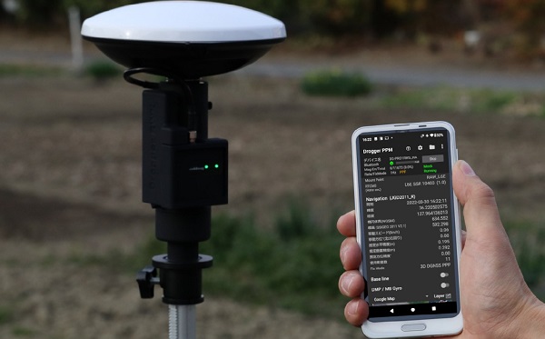
The solution leverages the strengths of two u-blox components. The first, a u-blox ZED-F9P multi-band high precision GNSS receiver module, is at the heart of BizStation’s DG-PRO1RWS GNSS receiver.
The second, a u-blox NEO-D9C correction-data receiver module specific to Japan, enables their virtual reference station to receive data on the QZSS L6E-band used by MADOCA.
The PPM (PPP positioning by MADOCA) Android application developed by BizStation then determines the location of the tracked device using the high-precision positioning data transferred via Wi-Fi from BizStation’s DG-PRO1RWS GNSS receiver as well as GNSS correction data from the virtual reference station. The PPM application performs all required calculations using the MADOCA positioning library developed by NEC Solution Innovators Co., Ltd.
The high-precision GNSS solution can be deployed either using a static or a mobile virtual reference station for a wide range of applications such as agriculture, drones, motor sports or surveying systems.