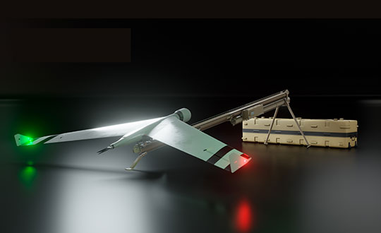
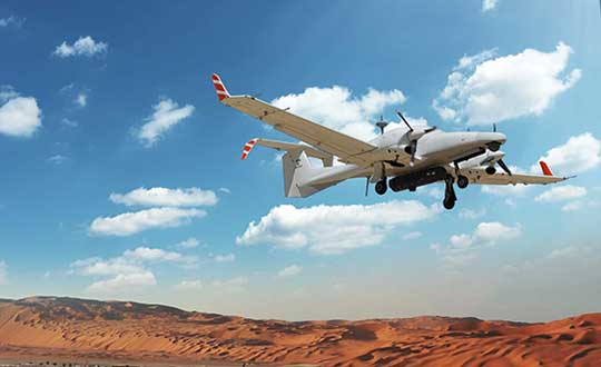
Zala Aero Group unveiled the ZX1, a new hybrid unmanned aerial vehicle (UAV), at the 2021 International Defense Industry Exhibition (IDEX) and Conference, which opened on Feb. 21 in Abu Dhabi.
The new drone has vertical-takeoff-and-landing (VTOL). According to Zala, it combines the best qualities of fixed-wing and multirotor types of UAVs; its configuration can change depending on the conditions of the performed task.
Ease of operation allows the UAV system to reduce the operator’s role, decrease the amount of equipment used when performing a flight mission, and fully automate flight processes of the UAV.
The ZX1’s onboard computer uses artificial intelligence, which makes it possible to process data in full high-definition, and transmit HD video and photos via encrypted communication channels to the GCS, ensuring the effectiveness of monitoring even before the aircraft lands.
The VTOL design makes it compatible with existing ZALA payloads, and also allows the installation of additional surveying equipment. It can be used to perform air monitoring for the fuel and energy sector and search-and-rescue operations from sites in urban environments.
Zala Aero Group, founded in 2004, is a Russian developer and manufacturer of unmanned aerial systems, payloads and mobile systems. It is now part of Concern Kalashnikov. Its main products are reconnaissance unmanned systems and digital solutions. Currently, more than 2,000 of Zala UAS operate within Russia. Areas of application are the protection of state borders, reconnaissance and rescue operations, monitoring of high-risk facilities and emergencies.
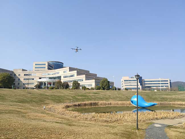
In early February, TopXGun Robotics — based in Shanghai, China — started to use 10L drones for spraying disinfectant to help fight COVID-19. Six volunteers provided free disinfectant spraying service to more than 10 large companies, factories and universities, covering about 800,000 square meters in the Shanghai area.
TopXGun outlined the advantage drones have over manual spraying.
Safety. Using a UAV means no wokers inhale disinfectant. Pilots stay distant, and no one enters a sprayed building until it is safe.
Effectiveness. By spraying from above, drones can reach difficult locations, such as a landfill or a roof. Reportedly, the spray can kill the virus in the air.
Cost-savings. Only one pilot and one assistant are required to operate, reducing labor costs.
The 10L drones are equipped with Septentrio’s high-precision GNSS, which provides robust anti-spoofing and anti-jamming capabilities, important in urban areas.
Before spraying, TopXGun used a XC-05 vertical-takeoff-and-landing (VTOL) drone to survey the area. With reliable real-time kinematic (RTK) technology from the Septentrio receiver, the survey drone accurately generated a map of the operation area, marking the flight route. In this way, the spraying drone could fly and spray automatically in most cases. If the operation area is in an irregular shape or has obstacles in the middle — such as poles or trees — the mapping pilot can use markers to indicate these obstacles so the spraying drone will avoid it.
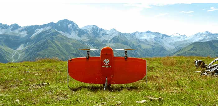
Site-survey preparations for a windfarm of 20 300-foot tall wind turbines might have been quite complex for a location in a 2,500-foot-high valley in the Swiss Alps.
However, the contractor decided to use a drone with vertical take-off and landing (VTOL) capability supplied by Wingtra to speed up the work and produce highly accurate geo-referenced data. Although multirotor drones are normally used for detailed survey work, they can cover much less area than fixed-wing drones during the same flight time. Fixed-wing drones can fly longer, farther and carry more weight.
Multicopters tend to carry more expensive, higher accuracy sensors because the sensors are not subject to potential damage from fixed-wing belly landings. Wingtra solved this problem by developing a drone with vertical take-off, the ability to transition to horizontal flight and to then land upright. When equipped with heavier, more accurate sensors, longer and more complex surveys are possible.
The Septentrio AsteRx-m2 was also chosen for the WingtraOne drone. The AsteRx-m2 is a high-precision, multi-frequency, four-constellation, PPK, low weight and power GNSS module. The low-latency AsteRx-m2 works for both rotorary- and fixed-wing UAV applications.
The WingtraOne VTOL drone is able to cover 400 hectares (an area of around 570 football fields) in one 55-minute flight. The resulting mapping accuracy is as high as 1.27 centimeters (0.5 inches). The drone was equipped with the full-frame 42MP Sony RX1RII camera, with seven ground control points for increased accuracy.
The WingtraOne took off vertically and transitioned to fly horizontally at the planned 1,500-foot altitude. Each flight took about 20 minutes to plan and involved 30 minutes of flying time. The flights covered a total area of 1,100 hectares — each flight was 200–300 hectares.
Aerial data collected from the site was converted to 3D models that allowed visualization of planned roads and wind-turbine locations in the wind farm. The data-collection workflow only took 4 hours rather than the days required with traditional surveying. Use of high-end sensors ensure survey-grade imagery and accuracy — in this case, the engineers obtained an accuracy of 3–4 cm.
Flying in an area as difficult as the Swiss Alps to collect aerial data has been one of Wingtra’s most complicated challenges. By reducing costs and the time to complete the survey and evaluation of the proposed site, the customer was able to maintain the overall wind farm project timelines.
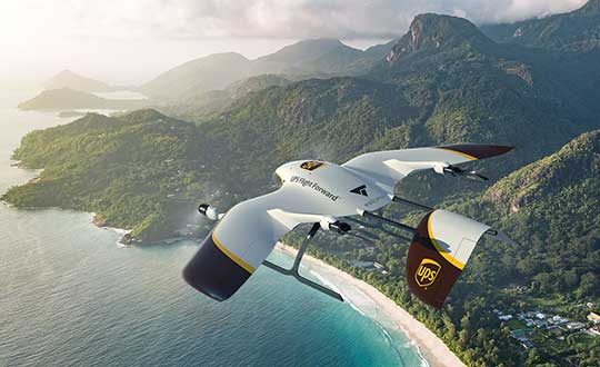
UPS Flight Forward (UPSFF) is collaborating with German drone-maker Wingcopter to develop the next generation of package delivery drones for a variety of use cases in the United States and internationally. UPSFF is a subsidiary of UPS dedicated to drone delivery.
UPS chose Wingcopter for its unmanned aircraft technology and its track record in delivering a variety of goods over long distances in multiple international settings.
“Drone delivery is not a one-size-fits-all operation,” said Bala Ganesh, vice president of the UPS Advanced Technology Group. “Our collaboration with Wingcopter helps pave the way for us to start drone delivery service in new use-cases. UPS Flight Forward is building a network of technology partners to broaden our unique capability to serve customers and extend our leadership in drone delivery.”
Drone fleet. As part of this collaboration — UPSFF’s first new relationship with a drone manufacturer since its formation — both companies will work toward earning regulatory certification for a Wingcopter unmanned aircraft to make commercial delivery flights in the United States. It also is a critical step toward building a diverse fleet of drones with varying capabilities to meet potential customer needs.
The Wingcopter drones feature vertical takeoffs and landings in tight spaces, transitioning to efficient, high-speed horizontal flight, enabling ranges suitable for a variety of uses. These capabilities will allow UPSFF to begin developing solutions that, if approved, will go well beyond the healthcare and retail industries to solve long-standing challenges for high-tech, industrial manufacturing, hospitality, entertainment and other customers.
Wingcopter drones have taken part in numerous beyond-visual-line-of-sight (BVLOS) projects and been used by diverse customers around the world — from commercial, factory-to-factory deliveries to life-saving humanitarian projects and emergency medical supply.
For example, Wingcopter delivered insulin to an Irish island in the North Sea that is frequently cut off from the mainland because of bad weather. On the South Sea island of Vanuatu, the start-up, on behalf of the local Ministry of Health and supported by UNICEF, successfully set up an on-demand vaccines supply, delivering the urgently needed serums within minutes to multiple different health centers.
Core innovation. The company’s electric vertical takeoff and landing drones have a patented tilt-rotor mechanism, which enables a seamless transition between two drone modes: multicopter for hovering and fixed-wing for low-noise forward flight. The aerodynamic Wingcopter aircrafts operate with stability even in harsh weather conditions.
In 2019, UPSFF began operating commercial drone delivery flights in the UPS network, starting with delivery service at WakeMed’s flagship hospital and campus in Raleigh, N.C. Since then, the company has delivered thousands of medical samples via drones, supplementing a ground courier service.
UPSFF later announced plans to establish drone delivery services on several healthcare campuses and has been exploring the use of drones to deliver retail, prescriptions and medical products in residential settings.
In September 2019, UPSFF received the U.S. government’s Standard Part 135 certification to operate a drone airline, and has also completed drone deliveries under the U.S. Federal Aviation Administration’s Part 107 rules within the FAA’s Integration Pilot Program.
“We are proud to partner with UPS, a global giant in delivery and logistics. Together we aspire to extend the speed and reach of package delivery,” said Tom Plümmer, Wingcopter chief executive officer and co-founder. “Our vision has always been to leverage technology to improve the lives of people around the world, and the strategic relationship with UPS will further accelerate our growth and global expansion, strengthening our role as an industry leader in drone technology.”
CP Aeronautics offers American-built combat-proven unmanned aerial systems for defense, homeland security and civil applications
CP Technologies has launched a new division, CP Aeronautics, to provide integrated turn-key solutions based on unmanned aerial systems (UAS) platforms, payloads, data links, ground control stations (GCS) and communications for defense and civil applications.
Designed as leading-edge UAS-based solutions, CP Aeronautics’ systems offer operationally proven solutions for intelligence, surveillance and reconnaissance (ISR) systems requirements. CP Aeronautics’ broad product portfolio has demonstrated excellent performance and operability in demanding environments, the company stated in a press release. Backed by continuous research and development, these systems are built on three decades of technological and operational experience.
“Through our in-house capability as a UAS manufacturer and integrator with specialist subsidiaries and technology partners, we offer a complete range of subsystems including air vehicles, inertial navigation and avionics, electro-optical payloads (EO), communications, propulsion systems, launch and retrieval systems, command and control units,” said Brad Pilsl, vice president of business development at CP Aeronautics. “We also offer high-end training solutions for our partners and customers.”
CP Aeronautics will support government and commercial customers with the entire infrastructure necessary for development, production, integration, flight-testing, certification and operational support of UAS throughout their service.
The combat-proven operational systems include:
Orbiter 2 Small-UAS (SUAS)
Orbiter 3 Small Tactical UAS (STUAS)
Orbiter 4 Small Tactical UAS (STUAS)
Aerostar Tactical UAS (TUAS)
Dominator XP (MALE UAS)
Pegasus 120 high-performance multi-mission vertical takeoff and landing (VTOL) UAS
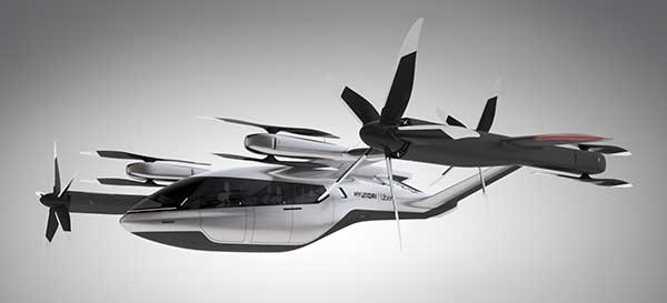
Hyundai is the first Uber Elevate partner with manufacturing capabilities to mass produce Uber Air Taxis
Uber and Hyundai Motor Company announced at CES 2020 a new partnership to develop Uber Air Taxis for a future aerial ride-share network and unveiled a full-scale aircraft concept. Hyundai is the first automotive company to join the Uber Elevate initiative, bringing automotive-scale manufacturing capability and a track record of mass-producing electric vehicles.
CES 2020, the massive annual consumer electronics show, is taking place Jan. 7-10 in Las Vegas. Hyundai Motor’s innovative smart mobility solutions including UAM, PBV, Hub and more are showcased at Booth 5431 in the Las Vegas Convention Center North Hall.
The taxi concept was created in part through Uber’s open design process, a NASA-inspired approach that jump starts innovation by publicly releasing vehicle design concepts so any company can use them to innovate their air taxi models and engineering technologies.
In this partnership, Hyundai will produce and deploy the air vehicles, and Uber will provide airspace support services, connections to ground transportation, and customer interfaces through an aerial ride-share network. Both parties are collaborating on infrastructure concepts to support take-off and landing for this new class of vehicles.
The SA-1 air taxi. (Photo: Uber/Hyundai)
“Our vision of urban air mobility will transform the concept of urban transportation,” said Jaiwon Shin, Executive Vice President and Head of Hyundai’s Urban Air Mobility (UAM) Division. “We expect UAM to vitalize urban communities and provide more quality time to people. We are confident that Uber Elevate is the right partner to make this innovative product readily available to as many customers as possible.”
“Hyundai is our first vehicle partner with experience of manufacturing passenger cars on a global scale. We believe Hyundai has the potential to build Uber Air vehicles at rates unseen in the current aerospace industry, producing high quality, reliable aircraft at high volumes to drive down passenger costs per trip. Combining Hyundai’s manufacturing muscle with Uber’s technology platform represents a giant leap forward for launching a vibrant air taxi network in the coming years,” said Eric Allison, head of Uber Elevate.
In preparation for this announcement, Hyundai worked with Uber Elevate to develop a PAV (personal air vehicle) model, S-A1, that uses innovative design processes to optimize electric vertical take-off and landing (eVTOL) aircraft for aerial ridesharing purposes. S-A1 previous eVTOL designs Uber Elevate has released in the following ways:
It is designed for a cruising speed up to 180 miles/hr (290 km/hr), a cruising altitude of around 1,000-2,000 feet (300 – 600 mt) above ground, and to fly trips up to 60 mile (100 km).
The Hyundai vehicle will be 100% electric, utilizing distributed electric propulsion and during peak hours will require about five to seven minutes for recharging.
Hyundai’s electric aircraft utilizes distributed electric propulsion, powering multiple rotors and propellers around the airframe to increase safety by decreasing any single point of failure. Having several, smaller rotors also reduces noise relative to large rotor helicopters with combustion engines, which is very important to cities.
The model is designed to take off vertically, transition to wing-borne lift in cruise, and then transition back to vertical flight to land.
The Hyundai vehicle will be piloted initially, but over time they will become autonomous.
The cabin is designed with four passenger seats, allowing riders to board and disembark easily and avoid the middle seat with enough space for a personal bag or backpack.
Ushering in the era of seamless mobility, Hyundai’s exploration of future urban transportation incorporates the electric PAV concept with a new ground transportation, the Purpose Built Vehicle (PBV) concept.
Hyundai’s vision for creating communities from future transit systems comes into focus with yet another new infrastructure concept, called the Hub. When many PBVs and PAVs are docked and connected to a Hub, they make a new public space where diverse groups of people can come together.
GE Aviation and Hybrid Project team to provide commercial high-endurance vertical takeoff and landing (VTOL) UAV, with Auterion and GE Aviation providing comprehensive integration of ground, cloud and airborne components
GE Aviation has teamed with Hybrid Project to provide a VTOL UAV designed for high-endurance commercial applications at scale. Flight testing is underway, with commercial availability targeted for the first quarter of 2020.
The agreement enables Hybrid Project’s 35-pound hybrid-powered SuperVolo VTOL UAV with a full stack airborne computing hardware platform, flight and safety management, and integration from GE Aviation and Auterion.
GE Aviation’s computing platform enables flight control and airborne computing power at the edge while maintaining an independent and authoritative safety controller. Auterion’s Enterprise PX4 operating system resides on the vehicle, in the cloud, and the ground station.
The integration is the result of an agreement announced earlier this year between GE Aviation and Auterion to provide all-in-one hardware and software platform for commercial drones.
“The combination of Hybrid Project’s SuperVolo airframe, GE Aviation’s computing platform, and Auterion’s software stack enables an all-in-one solution that readily scales for commercial applications,” said Matt Vacanti, product leader, Avionics Systems for GE Aviation. “A highly integrated system is critical to achieving scalable commercial UAV operations.”
Hybrid Project’s SuperVolo has been designed from the ground up with an emphasis on endurance flight, ease of maintenance, and modularity. The combined system is comprised of technologies and services which have the capability to enable commercial operations in complex environments while meeting regulatory and mission outcomes.
“This collaboration, and the combined solution, will increase commercial operator flexibility, efficiency, and overall performance to a level not previously available in its class,” said Ryan Pope, co-founder of Hybrid Project.
Auterion’s Enterprise PX4 software is built on top of open software standards that are supported by a global developer community. Auterion’s enterprise software also provides the infrastructure enabling online workflows, compliance monitoring, and enterprise fleet management. “With Auterion software, the Hybrid Project SuperVolo flies farther, safer, and more efficiently, unlocking new BVLOS capabilities and missions that were previously not possible before commercial drones of this class were available,” said Kevin Sartori, co-founder of Auterion.
Bell Helicopter unveiled a full-scale vertical-takeoff-and-landing (VTOL) air taxi vehicle during CES 2019, held in Las Vegas.
The air taxi, named Bell Nexus, is powered by a hybrid-electric propulsion system and features Bell’s signature powered lift concept incorporating six tilting ducted fans designed to safely and efficiently carry passengers.
Bell Nexus means the nexus of transport and technology and of comfort and convenience. Nexus captures the long-sought-after vision of quick air travel with a unique in-flight experience, keeping passengers connected to their lives and saving valuable time.
The Nexus team consists of Bell, Safran, EPS, Thales, Moog and Garmin, who are collaborating on Bell’s VTOL aircraft and on-demand mobility solutions. Bell is leading the design, development and production of the VTOL systems; Safran is providing the hybrid propulsion and drive systems; EPS is providing the energy storage systems; Thales is providing the Flight Control Computer (FCC) hardware and software; Moog is developing the flight control actuation systems; and Garmin is integrating the avionics and the vehicle management computer (VMC).
Autonomous Pod Transport (APT). Alongside the debut of Bell Nexus, Bell will feature the Autonomous Pod Transport (APT). The APT family varies in payload capability that can serve many mission sets such as medical, law enforcement, offshore missions and on-demand delivery services. Bell is expanding into a new industry to show the full spectrum of our capabilities and the real-world challenges APT will address, Bell said in a press release.
Future Flight Controls. Bell’s Future Flight Controls simulator was a new experience for CES participants this year. Bell is actively collecting data to help shape the future flight controls of aviation. Data from the simulators will be used to determine what actions and interfaces are intuitive to the average potential operator and what prior experiences and abilities contribute to these opinions.
Urban air travel is coming closer to the masses through recent advancements in technology and software. The critical last step is designing a flight-control ecosystem that allows individuals to safely and efficiently operate urban air vehicles.
In 2018, Bell provided the world a glimpse into the air-taxi passenger experience, and this year, attendees could see the full vision.
As part of ongoing global expansion, Microdrones has merged with Schübeler Technologies. Since its founding in 1997, Schübeler has built a global business by providing advanced fan propulsion jets and lightweight composite materials fabrication.
Offering a full product lineup of robust turbo fans, jets, compressors, pumps, electric motors, carbon fiber and aluminum composites, Schübeler products are designed to withstand extreme conditions and demanding field use. These components provide thrust power and lightweight durability to high-tech applications including UAVs, professional motorsports and heavy-duty outdoor equipment.
Microdrones, founded in 2005, has evolved from a manufacturer of commercial-grade unmanned VTOL aircraft to a provider of fully integrated systems for surveying, mapping, lidar and inspection applications. These systems are being put to use worldwide by professionals in the construction, mining, energy, agriculture and infrastructure trades.
“We make life easier for professionals by offering the full solution; it has proven to be a successful strategy,” said Microdrones President Vivien Heriard-Dubreuil. “Perfectly integrated drones, sensors, software, workflow, training and support is what the market needed. Welcoming the Schübeler team, talent and capabilities to Microdrones delivers new aviation technology and capabilities to our customers in the form of next generation unmanned aircraft.”
As the preferred provider of VTOL solutions to Trimble Dealers worldwide, Microdrones adds a global sales force and distribution network as well as technical centers and production sites spanning seven countries and three continents.
“Merging with Microdrones empowers us to develop and deliver systems where we can best support customers locally,” said Daniel Schübeler, founder and CEO of Schübeler Technologies. “This is a happy homecoming for me and the team that we’ve built over the past 20 years.”
Schübeler was an original founding partner in Microdrones and helped develop the pioneering technology that helped Microdrones gain global recognition for professional VTOL UAVs. He adds, “Both of these companies have enjoyed global growth and impressive technological advancements independently. Merging our talents and teams will yield amazing solutions in the years to come.”
“This is a strategic growth initiative,” explained Francois Gerner, SVP of Corporate Affairs at Microdrones. We are adding technology, IP, talent, strong leadership and investment capabilities that are complementary to both brands. This deal brings us to more than 150 highly skilled employees worldwide, which translates to better products, service and support.”
The merged companies will retain the Schübeler Technologies brand, which commands a niche’ audience of serious aeromodeling enthusiasts. Schübeler Technologies will continue to serve these markets as well as tackle large-scale custom R&D projects related to propulsion and materials.
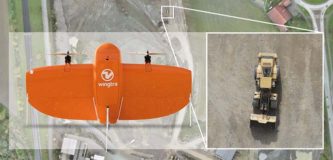
Belgian GNSS receiver manufacturer Septentrio was selected by Swiss drone manufacturer Wingtra to supply GNSS OEM receiver boards and PPK processing software for the recently-launched WingtraOne PPK drone.
The combination of vertical take-off and landing (VTOL) technology and a high-spec post-process kinematics (PPK) brings wide-area coverage at ultra-high precision.
Following a flight, the GNSS data of the WingtraOne is processed offline using Septentrio’s PPK software. This combines the drone data with correction data from a nearby reference receiver to get accurate cm-level geolocations for every photograph.
The on-board high-resolution Sony RX1RII camera, AsteRx-m2 UAS receiver board combined with Septentrio’s PPK library, and Pix4D photogrammetry processing software are together able to produce ground precisions of 1.3 centimeter (cm) horizontal and 2.3 cm vertical.
Image: Wingtra
“With the WingtraOne PPK, we can offer a world first in drone photogrammetry — wide coverage at ultra-high precision,” said Armin Ambühl, CTO of Wingtra. “In a single one-hour flight, the WingtraOne can cover 130 ha (320 acres) delivering mapping with GSDs [ground sample distance] below 1 cm/pixel with absolute accuracy down to 1.27 cm.”
He continued, “WingtraOne’s advantage is twofold: it combines VTOL with the latest PPK technology from Septentrio. With VTOL we can offer the best of both worlds: multirotors and fixed-wings. Vertical take-off and landing means hands-free operation and a smoother ride for the on-board camera payload. Secondly, efficient flying in fixed-wing mode means far greater coverage than any comparable multirotor.”
“We are proud and excited to be part of this innovative project with Wingtra pushing the boundaries of aerial photogrammetry,” said Gustavo Lopez, product manager at Septentrio. “The WingtraOne incorporates our AsteRx-m2 UAS OEM board and, photogrammetry applications requiring high-precision, low-latency positioning are what it does best. The board is specifically designed for quick and easy integration and, with Septentrio’s world-first, multi-frequency PPK, cm-level precision can now reach the parts dual-constellation solutions feared to tread.”
SkyX Systems Corporation has successfully completed an unmanned data-collection flight of 100 kilometers (km), one of the longest journeys in its class.
The firm flew its SkyOne unmanned aerial system (UAS) on an autonomous data mission over more than 100 km of gas pipeline in Mexico. The robotic flight was programmed and monitored remotely from the company’s Greater Toronto Area SkyCenter mission control, with a support crew of engineers on the ground in Mexico.
Using high-resolution imagery, the longest of multiple flights identified more than 200 potentially significant anomalies along the remote pipeline, ranging from unauthorized buildings and cultivation, to a fissure possibly caused by seismic activity.
More than $38 billion is spent annually monitoring oil and gas pipelines using less efficient means. The SkyX System flight gathered data in a little more than an hour that would have taken a person well over a week. It identified more than 200 georeferenced anomalies the customer was unaware existed, pinpointing precise coordinates for rapid investigation and remediation.
The SkyX System consists of a vertical takeoff and landing (VTOL) drone, the SkyCenter control room, which allows for real-time and secure mission monitoring from remote locations, as well as the company’s proprietary SkyBoxes that enable SkyOne to recharge and continue long-range missions without having to return to home, a factor that limits many drones.
Using the system, a client doesn’t need a trained pilot to operate a remote-control unit — the entire mission is programmed and carried out autonomously, from takeoff to landing. Plus, the VTOL drone eliminates the need for runways, launchers or capture devices.
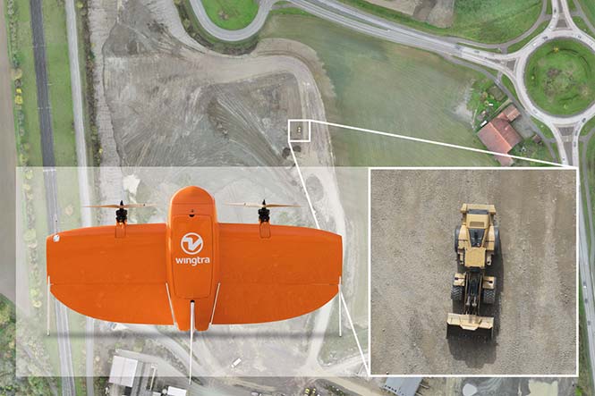
Professional drone company Wingtra is partnering with photogrammetry company Pix4D. Pix4D’s software suite is now available to WingtraOne users, both directly and via Wingtra’s distributors.
WingtraOne, Wingtra’s main product, is a vertical take-off and landing (VTOL) UAV that enables data collection for a variety of industries. The partnership with Pix4D aims to augment its status with an end-to-end solution including 2D map and 3D model construction from aerial data.
The WingtraOne drone bridges the gap between traditional multi-rotors and fixed-wing drones, the company said. It takes off and lands vertically like conventional multirotors, but once in flight, the drone tilts forward to fly like a fixed-wing aircraft.
Being able to carry heavy payload such as the Sony RX1RII, the drone offers high mapping accuracy, while covering an area of 980 acres (400 Ha) at 3 cm/px (1.2 in/px) GSD or the equivalent of 570 football fields.
The WingtraOne is available in use in Europe, China, the United States and Australia for applications ranging from surveying and precision agriculture to glacier monitoring.
Wingtra (booth 109) and Pix4D (booth 415) are exhibiting at Commercial UAV Expo Americas, which takes place Oct. 24-26 in Las Vegas.
Map made by Pix4D pictures taken by WingtraOne with RX1RII camera. (image: Wingtra)
Turning Information into Insight. Wingtra’s diverse user base is complemented by Pix4D, whose product range is aimed at the surveying and agriculture industry, among others.
Pix4D has allows professionals to generate high-quality point clouds, orthomosaics, surface and terrain models from aerial imagery. Some of its popular offerings include Pix4Dmapper for precisely georeferenced 2D maps and 3D models, and Pix4Dag for accurate reflectance and index maps (NDVI, NDRE).
With WingtraOne’s autonomous aerial data collection and Pix4D’s advanced data-analysis capabilities offered as a single bundle, professional users can now expect a plug-and-play solution. “We are keen on collaborating strongly in our upcoming events. Actually we are meeting very soon at UAV Expo in Las Vegas,” Bailey said.
“The bond between the companies was established some time ago, since realizing the potential of pairing high-resolution aerial images with cutting-edge photogrammetry modeling software,” said Caroline Bailey, Pix4D regional sales manager for Europe. “We are very happy to announce the decision to become official partners.”
Leopold Flechsenberger, sales manager at Wingtra, added, “We have always aimed at providing the best survey-grade aerial imagery to our users, so Pix4D was an obvious choice from the start. From now on, Wingtra is offering a reduced price on WingtraOne drones, when bundled with Pix4Dmapper.”