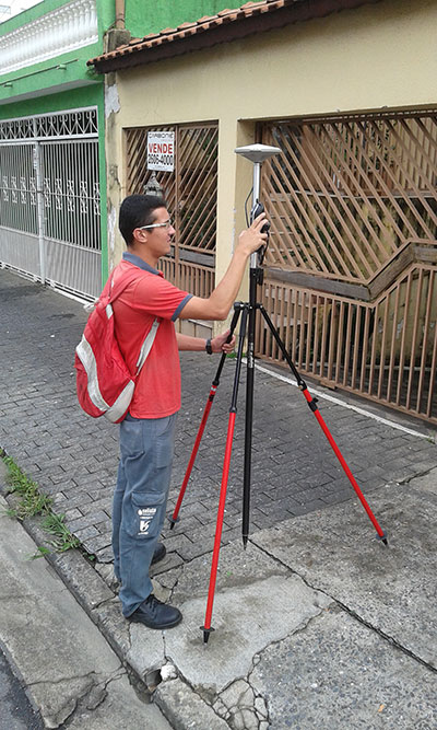
Fugro has commissioned an additional airborne laser bathymetry system to underpin its position in the development and application of bathymetric LiDAR technology. The combined Fugro LADS Mk 3 and Riegl VQ-820-G systems provide seamless measurements and mapping of nearshore and shallow water environments. The increased capability will enable Fugro to deliver simultaneous topographic and bathymetric surveys in multiple geographical areas.
With high power and frequency, the combined systems achieve superior coverage that minimizes gaps and outperforms lower energy alternatives and single-sensor systems in all conditions, particularly in difficult environments, Fugro said. They are highly adaptable and small enough to be installed in a variety of light aircraft.
With continued operations across the Middle East during 2015, Fugro will also begin a South West Pacific ALB survey campaign following the award of projects in multiple locations to support nautical charting, coastal engineering, scientific assessments, coastal management, benthic habitat mapping and climate change initiatives.
Since 2012, Fugro has operated simultaneous topographic and bathymetric LiDAR systems in France, Japan, New Zealand and the Middle East. Successful results from Japanese coastal areas include returns from the Fugro LADS Mk3 sensor to 50 meters while recent surveys in Saudi Arabia had even more impressive results, with 65-meter depth returns. The deep water returns combined with high-density shallow water and near coastal returns result in a seamless dataset from ridge to deep reef.
Users will learn how to configure the templates based on their own content, and then deploy them to support common inspection workflows.
After viewing the seminar, users will understand how to
Organize your content for field inspections.
Collect inspection information while in the field.
Summarize inspection results for reporting.
GIS managers and analysts who use ArcGIS software and need to learn how to prepare, collect, and summarize inspection information will find this seminar useful.
Participants will need a broadband Internet connection and an Esri account to watch the live training seminar. Esri accounts can be created at esri.com/lts. click Login at the top right, and register name and e-mail address.
Saneamento Basico do Estado de São Paulo (SABESP), a Brazilian water and sewage collection utility owned by São Paulo state and Latin America’s largest water company by market capitalization, has selected Spectra Precision ProMark 120 and 220 GNSS receivers to assist in gathering the geographic location of all SABESP network assets and the location of all customers.
SABESP provides water to more than 28.7 million customers, or 67 percent of the population of São Paulo state. Water loss due to leakage in the SABESP network is a significant problem. The biggest reason behind water loss is leaks in the network; additional factors include sub-metering, caused by low water pressure; unauthorized consumption; and fraud.
Improving water management, recovering lost revenue and improving the quality of the customer experience is a priority for SABESP, Spectra Precision said. To help improve revenue generation and reduce water loss, SABESP developed two projects: LigGeo, to geo-reference the water meter location of approximately 4.8 million SABESP customers; and CadGeo, to geo-reference and register the location of the SABESP water and sewage network infrastructure.
According to Marcos Almir, sanitation systems analyst for the metropolitan department of development and management of SABESP, the twin projects of LigGeo and CadGeo were motivated by SABESP’s desire to improve productivity and competitiveness. “We created an innovative GIS effort to geo-reference and register SABESP distribution networks and buried assets. Tests showed the technical feasibility of using ProMark GNSS receivers and collectors with NTRIP technology to efficiently and effectively register all SABESP equipment in real time with geo-referenced attributes connected to the technical and commercial enterprise systems to optimize processes and reduce costs.”
To implement the LigGeo and CadGeo projects, SABESP purchased 50 ProMark 120 and 220 GNSS receivers from Hezolinem Equipamentos Topograficos, Spectra Precision’s Brazil dealer. Both SABESP technicians and outsourced service providers will use the receivers.
ProMark 120/220 GNSS receivers were chosen for their multiple advantages: They could be purchased as rovers only; they could run LigGeo and CadGeo proprietary software; they are compatible with local third-party networks, including CEGAT, Brazil’s largest private RTK geodetic base network, that delivers RTK network corrections enabling real-time accuracy of less that 20 cm; and they offered direct two-way 3G communication of information with the SABESP central cartographic base raster files.
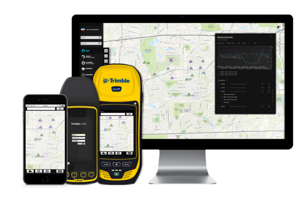
Trimble introduced today its next generation suite of software applications for water, wastewater and stormwater utilities — Trimble Unity. Trimble Unity replaces Trimble Connect for Water and offers a unified cloud-based and mobile collaboration platform for smart water mapping and work management.
Trimble Unity applications, or “apps,” support the following workflows:
Mapping: Field and office GIS visualization and mapping of assets with up to centimeter-level accuracies
Maintenance: GIS-based asset maintenance and inspection forms and business processes
Service: Customer field service work order and mobile workforce management
Metering: Smart water meter deployment, installation and maintenance
Monitoring: Visual and real-time monitoring of field operations and utility networks
Analytics: Dashboards and performance management reporting
Trimble Unity represents a unified collaboration platform for managing critical utility assets and the work of water industry professionals. By integrating GIS and field operations, sensors and wireless communications, mobile workers and office professionals, field and back office enterprise systems, and utilities with their contractors, Trimble Unity provides the water industry with a comprehensive solution for regulatory reporting, improving operations, reducing cost and enhancing customer service, the company said.
Trimble Unity is designed to automate a variety of industry workflows through individual “apps” offered within the software suite, enabling utilities to deploy smart meters, assess the condition of assets, repair leaks and reduce non-revenue water (NRW), and locate and map critical infrastructure using Trimble high-accuracy GNSS mapping technologies. The software can also assist utilities in reducing spills and environmental damage, extending the life of aging assets and helping improve worker safety and productivity.
Through a Trimble Unity software-as-a-service (SaaS) subscription, organizations can provide a single solution for the office and the field, choosing any combination of Trimble and non-Trimble mobile devices, including iOS, Android, Windows Mobile and Windows 7/8 smartphone, tablets and laptops. The software also integrates the latest Esri ArcGIS Server, mobile and ArcGIS Online map services enabling organizations to leverage their existing investments in GIS technology.
Proteus FZC, a provider of satellite-derived mapping and classification services, is now offering a daily water quality monitoring service for the Arabian Gulf. Derived from NASA satellite data, the new service provides daily online access to reports on six water quality parameters at 250-meter to 1-kilometer spatial resolution.
“We can further improve the accuracy of the standard NASA data by calibrating each data set to local water conditions,” said Proteus CEO David Critchley. “The easy-to-read reports are available online or can be delivered in PDF formats via email.”
Proteus now offers the daily service for organizations responsible for monitoring and maintaining the condition of coastal and offshore waters — environmental agencies, energy producers, desalination operators, marine engineering firms, and dredging companies.
“If an offshore infrastructure construction project is responsible for excessive water turbidity, the engineering company has to remediate the problem quickly,” Critchley said. “Likewise, desalination and power plants need to take precautionary actions if too much suspended sediment or sudden algal blooms are spotted near their operations.”
The daily water quality reports are derived from processed data collected by the MODIS (Moderate Resolution Imaging Spectroradiometer) sensors which fly aboard the orbiting NASA Terra and Aqua satellites.
“The sensors typically provide water quality details to a depth of three meters, depending on water column clarity,” said Critchley
The daily water quality reports provide the following information:
Total suspended sediments (mg/L) at 250-meter resolution
Chlorophyll-a content (mg/m3) at 1-km resolution
Sea surface temperature (degrees C) at 1-km resolution
Turbidity or fluorescence line height (mW/cm2/µm/sr) at 1-km resolution
Diffuse attenuation coefficient (m-1 at 490 nm) at 1-km resolution
True color composite (image) at 250-meter resolution
The 250-meter resolution is suitable for marine monitoring because it enables data collection for the entire gulf region several times per day. When the regional 250-meter resolution MODIS-derived product reveals a water quality anomaly or if increased spatial detail is required, Proteus water quality customers have the option of requesting higher resolution reports processed from other satellites that can map events in more detail.
“We will soon expand the daily water quality monitoring service to ice-free oceans, seas and large lakes worldwide,” Critchley said.
Under the theme “Taking the Pulse of the Planet,” 275 members of the GEO community from more than 45 countries will chart the next steps in creating and implementing a Global Earth Observation System of Systems (GEOSS) during the Group on Earth Observations (GEO) Eleventh Plenary Session. The session will be held November 12-14 in Geneva, Switzerland.
A highlight of the conference will be announcement of the winners of the GEO Appathon, a global app development competition built on the 80-million-plus resources available through GEOSS. The Appathon attracted 250 competitors from 50 countries, and will generate easy-to-use decision tools for mobile devices and computers.
GEO’s mandate is to harness the power of Earth observations from sources across the globe to provide more and better information to leaders in government, industry, and civil society confronting fundamental decisions affecting people and societies worldwide. One key GEO initiative that will be highlighted during the meeting is developing a comprehensive system to monitor the availability and quality of fresh water, in partnership with the World Health Organization, the UN Environmental Programme and other UN agencies as part of the UN Sustainable Development agenda.
GEO is leading the creation of an Africa-wide technological and human infrastructure so decision makers have the capacity to access and use Earth observations in making key decisions. To strengthen agricultural activity and reduce market volatility, GEO is coordinating the assessment of growing conditions of the world’s major crops through a combination of regional expertise, ground observations and analysis of meteorological and satellite data.
GEO is a voluntary partnership of governments and organizations that envisions “a future wherein decisions and actions for the benefit of humankind are informed by coordinated, comprehensive and sustained Earth observations and information.” Members include 94 nations and the European Commission and 77 participating organizations comprised of international bodies with a mandate in Earth observations.
GEO’s agenda spans nine Societal Benefit Areas, including agriculture, biodiversity, climate, disasters, ecosystems, energy, health, water and weather.
Trimble has introduced the latest version of its smart water infrastructure mapping and work management cloud software — Trimble Connect for Water version 1.9.
The latest release of the geographic information system (GIS) centric software-as-a-service (SaaS) adds real-time, high-accuracy centimeter-level horizontal and vertical GNSS accuracy for capturing 3D asset positions. The new release includes a suite of applications that allow water, wastewater and stormwater utilities to accurately locate, inventory and visualize their infrastructure assets and increase operations and maintenance efficiency.
Trimble Connect for Water cloud software leverages Trimble’s GNSS rugged mobile devices and Esri’s GIS technologies to accurately map, locate and assess the condition of critical infrastructure assets, allowing utilities to keep their field infrastructure data up-to-date and accurate.
The new release now supports Trimble’s Geo 7 Centimeter Edition rugged handheld, integrating 3D mapping into utility field workflows and enabling mobile workers to precisely locate and map the horizontal position and elevation of buried infrastructure.
Trimble Connect for Water version 1.9 can be configured and deployed quickly on a variety of Trimble and non-Trimble mobile devices, laptops, tablets and smartphones, including Apple iPads, iPhones, Android, Windows and Windows Mobile devices to automate fieldwork and eliminate paper-based maps.
Trimble Connect uses the latest Esri ArcGIS for Server, Mobile and ArcGIS Online basemap services. The software is designed to automate a variety of specific water, wastewater and stormwater industry workflows through individual pre-configured “apps” offered within the product and as part of a subscription.
The new version provides standard core apps including Map Book, Manhole Inspector, Leak Repair, Hydrant Inspector, Valve Inspector, Meter Changeout, Incident Repair, Water Mapper, Wastewater Mapper and Stormwater Mapper. In addition, an optional partner app developed for American Flow Control (AFC) hydrant and valve data collection, “AFC Mapper,” can be purchased from AFC and their distributors for use with Trimble rugged handhelds.
Trimble Connect for Water version 1.9:
Offers centimeter-level real-time GNSS accuracy to improve the quality and accuracy of the utility’s GIS data to precisely locate hard to find assets.
Allows capturing accurate vertical elevations in real-time. Combined with horizontal precision, the solution provides high-accuracy GIS data that can be used to measure pipeline slopes, perform flow analysis and generate 3D and hydraulic models.
Supports the Trimble Geo 7 Centimeter edition with an integrated laser rangefinder.
Offers pre-configured Water, Wastewater and Stormwater mapping apps, allowing utilities to quickly start mapping network infrastructure and updating their asset data.
Provides the capability to export data in a variety of formats including Esri File Geodatabase, Shapefiles and MS Excel, which allows users to update the utility’s enterprise GIS or visualize and analyze the collected data using third-party systems.
Trimble Connect for Water version 1.9 is expected to be available in December 2014 from Trimble’s Water Division and its authorized distribution partners.
Trimble has introduced the latest version of its smart water infrastructure mapping and work management software — Trimble Connect version 1.8. The latest release of the cloud-based, geographic information system (GIS)-centric software includes a suite of applications that allow water, wastewater and stormwater utilities to visualize and efficiently manage their network maintenance and data collection activities.
Trimble Connect software leverages Trimble’s GNSS rugged mobile devices and Esri’s GIS technologies to accurately map, locate and assess the condition of critical infrastructure assets, allowing utilities to keep their field infrastructure data up-to-date and accurate. Offered as a software-as-a-service (SaaS) subscription, the solution allows users to monitor asset operating conditions, manage leak repairs, reduce non-revenue water, deploy and inspect smart meters, lower potential threats to safety and health due to contamination and adhere to regulators’ reporting guidelines and requirements. Trimble Connect version 1.8 can be configured and deployed quickly on a variety of Trimble and non-Trimble mobile devices, laptops, tablets and smartphones, including Apple iPads, iPhones, Android, Windows and Windows Mobile devices to automate field workflows and eliminate paper-based maps.
Trimble Connect utilizes the latest Esri ArcGIS 10.2.2 for Server, Mobile and ArcGIS Online basemap services. The software is designed to automate a variety of specific water and wastewater industry workflows through individual “apps” offered within the product and as part of a subscription. The new version provides standard core apps including Map Book, Manhole Inspector, Leak Repair, Hydrant Inspector, Valve Inspector, Meter Changeout, Incident Repair, Water Mapper, Wastewater Mapper and Stormwater Mapper. In addition, an optional partner app developed for American Flow Control (AFC) hydrant and valve data collection, “AFC Mapper,” can be purchased from AFC and their distributors for use with Trimble rugged handhelds.
In addition to the standard core apps, Trimble Connect version 1.8 includes:
Full offline mobile support including GIS data for Android, iOS, Windows Mobile and Windows 7/8 platforms
Esri ArcGIS Online (AGOL) support to create and share Web Maps using data collected in Trimble Connect
Work management support for single and multi-asset work orders on all supported platforms
Enhanced workflows for asset inspection and condition assessment
Embedded business rules to define failed inspections or ones that need review
Enhanced workflows for asset mapping and data collection
Support for the Trimble Geo 7 series rugged mapping handheld and integrated Laser Rangefinder
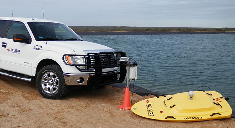
Proper management of large volumes of fluid has become a necessity as hydraulic fracturing has increased throughout North America. Creating the most effective fluid handling solution involves environmental, cost and project timeline considerations.
Select Energy Services, LLC, has launched AquaView, a suite of services that efficiently monitor water at various stages of the project through real-time, wireless technology. AquaView’s instant monitoring capabilities allow Select to respond immediately to on-site issues before emergencies arise.
AquaView capabilities include pit and reservoir hydrographic surveys utilizing SONAR remote control and GPS real-time data; data delivered to a secure portal offering current and historical data; real-time water quality reporting; and mapping and geographic information systems (GIS) support. The system can transmit the data with enabled access through computers, smartphones, tablets and text messages.
“This new technology is changing the way our industry does business,” said John Schmitz, Select Energy Services CEO. “AquaView will reduce down time and assist in the maintenance of completion schedules, essentially removing the need for traditional water tracking and measurement systems.”
Select’s team is capable of water transfer, containment assembly, water fill and complete removal or disposal.
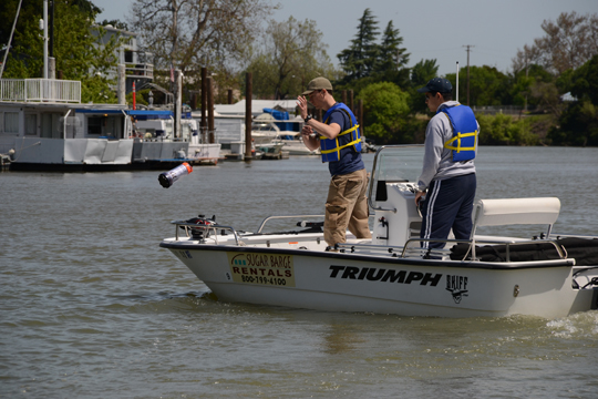
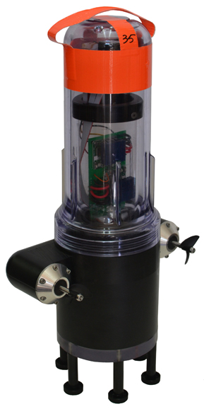
UC Berkeley researchers have developed a method to provide real-time, high-resolution data in hard-to-map waterways, using GPS. Tossing a robot is Andrew Tinka, with Kevin Weekly. (Photo courtesy of Jérôme Thai.)
By Tracy Cozzens
A fleet of 100 robots equipped with GPS and sensors were released May 9 into California rivers to measure water flow, salinty levels, and pollution. The Floating Sensor Network is a project by the University of California, Berkeley, to improve the way water quality and flows are monitored.
About two-thirds of California’s fresh water is in the Sacramento-San Joaquin river system where the test took place. This water supplies about two-thirds of the state’s population with drinking water and irrigation. The initiative is led by associate professor Alexandre Bayen at the Center for Informatin Technology Research in the Interest of Society (CITRIS).
The robots each have a sensor to test salinity and a GPS unit from a smartphone. Some have propellers so they can maneuver around obstacles and reach specific destinations. The robots also sent Tweets to @fsnandroid61.
The robots drifted through the area of the river being measured, then were retrieved by boat. “One advantage of our real-time communication system is that we can see where all our sensors are on a map, which makes it very easy to chase them down and retrieve them,” said graduate student researcher Andrew Tinka.
With the first test completed, the team’s efforts over the summer have two priorities, Tinka explained. “First, we’re using the flow data that we gathered on May 9 to understand how this ‘mobile’ data can be best used for river hydrodynamics studies. We’re learning how to turn the individual traces of water that each sensor gives us into a big-picture view of the entire river region, sort of how like meteorologists take the data from a few weather stations and turn it into an overall view of what the weather is doing over a large area. Second, we’re working with other hydrodynamics research groups to expand the use of this kind of mobile sensor. We’re loaning our equipment to other groups, doing pilot projects with others, and basically trying to get these sensors into researchers’ toolboxes throughout the water community.”
There are two types of devices in the fleet, active and passive. The active sensors have a twin-propeller drive system that lets them move through the water to avoid obstacles or stay in the correct region of the river. “We developed the internal electronics for this device ourselves,” Tinka said. “We integrated a Magellan AC12 GPS receiver along with a Gumstix embedded computer and a Motorola GSM module. Our passive sensors don’t have a propulsion system; they do exactly what the water does. We developed this system with a focus on cost and ease of assembly.” The team used a waterproof consumer smartphone, the Motorola Defy, for the GPS positioning, computation, and comunications.
So far, the test has proven the usefulness of such a network. The devices were developed to be easily deployable, especially where a lot of flexibility is needed, such as in disaster response. “The ability to quickly and easily put these sensors into new inland environments, by just about any method (throw them from a boat, drop them from a helicopter, toss them from a dock or a bridge) makes them a really useful new tool,” Tinka said.
photos courtesy of Jonathan Beardphotos courtesy of Jonathan Beard
A hundred robots, 40 with propellers, were released into the Sacramento River near Walnut Grove (photos courtesy of Jonathan Beard).