Russian acts targeting critical infrastructure, satellite signal interference paralyzing maritime and air navigation, and cognitive operations aimed at intimidating European societies are examples of Russian hybrid activities targeting the Baltic Sea region states.
The paper, “White Paper on Russian Acts of Sabotage and Subversion against Members of the Council of the Baltic Sea States,” can be downloaded here. Authors Filip Bryjka, Anna Maria Dyner and Aleksandra Kozioł are with the Polish Institute of International Relations.
The report explores GNSS signal disruptions in the Baltic Sea and how it affects the safety of maritime and air traffic.
Scale and Methods of Russian Operations
Since the beginning of the full-scale invasion of Ukraine, Russia has intensified its hybrid activities against NATO member states, particularly those that have most actively supported Ukrainian resistance. This group includes the members of the Council of the Baltic Sea States. It is against them that the vast majority of acts of diversion and sabotage recorded in Europe since February 2022 have been directed.
Russia deploys a full spectrum of tools against the region:
Acts of diversion and sabotage targeting critical infrastructure.
Border incidents: Violations of airspace and maritime borders.
GNSS signal disruptions (satellite radio transmissions), creating operational problems for maritime and air navigation.
Cognitive influence, aimed at causing measurable damage, testing state responses, and inducing a sense of growing threat among societies.
Recommendations: How to Counter Hybrid Threats?
The offensive nature of Russian actions demonstrates an intent to destabilize NATO and EU countries. Effective defense requires developing shared mechanisms:
Close cooperation among agencies: Ensuring a high level of situational awareness through the coordination of activities (at both national and international levels) among military and civilian intelligence, counterintelligence, border guard services, and the police.
A dedicated information exchange system: Leveraging the geographical proximity and potential of the CBSS states to quickly share threat data.
Unambiguous attribution of persuasions: Publicly naming Russia as the author of the attacks. A lack of clear attribution hinders coordinated preventive and retaliatory measures.
A catalog of best practices: Developing common rules for monitoring, reporting, and responding to known and repetitive Russian operational patterns.
The authors conclude that only a full spectrum of coherent measures taken by all states in the region, alongside NATO and EU structures, can effectively influence Russia and reduce the risk of future incidents.
Nestwave has released a white paper that considers the challenges associated with integrating accurate geolocation into compact, battery-powered, low-cost internet of things (IoT) nodes.
The technical paper “Minimizing Power Budgets to Enable Geolocation on Every IoT Device” is targeted at engineers and developers looking to add accurate positioning functionality to IoT technologies where power requirements must be kept to an absolute minimum.
Topics covered include:
why conventional tracking architectures are not suitable for many IoT implementations
the importance of factors such as time-to-first-fix (TTFF)
the number of fixes and levels of integration in determining power consumption.
The paper introduces new ways of handling positioning signal acquisition, ranging and tracking, and proposes solutions that eliminate the need for a separate GNSS-integrated circuit and that offload energy-intensive computation to the cloud.
“Tracking will be an important element in the evolution of the IoT, which means making accurate geolocation viable for every single IoT node is absolutely critical,” said Ambroise Popper, Nestwave CEO. “This paper explains why traditional solutions are too power-hungry, too large and too expensive to meet the energy, form factor and cost constraints of most IoT devices and introduces solutions for addressing the challenge.”
Tersus GNSS has released a white paper on ExtremeRTK Technology. According to the company, the white paper demonstrates how ExtremeRTK Technology delivers excellent performance in all manner of surveying scenarios and describes its impressive compensated results when performing tilt surveys — even tilt at angles greater than 90°.
As a professional real-time kinematic (RTK) developer and manufacturer, Tersus believes the stability and accuracy of RTK are the cornerstones of RTK measurement.
According to the paper, “ExtremeRTK integrates the receiver’s hardware, high-precision baseband IC [integrated circuit], RTK engine, GNSS/INS coupling algorithm, etc. It enables unprecedented performance stability in challenging environments and prevents occurrences of occasional RTK positioning outliers.”
Tersus starts from scratch — engineering each element from its foundation in the physics of GNSS. From signal capture and baseband tracking engine to position-velocity-time (PVT) results and the overall algorithm of RTK, Tersus completes all algorithm logic independently.
The white paper discusses:
signal tracking and multipath mitigation capabilities
fix speed in open-sky and challenging environments
accuracy when performing RTK control/detail point/continuous point surveys
GNSS/INS tilt compensation.
Test results described indicate the remarkable performance of ExtremeRTK technology in RTK initialization, accuracy and tilt compensation. Based on ExtremeRTK, Tersus will continue to invest in the further development of RTK receivers by adding photogrammetry, laser scanning and more.
Meanwhile, Tersus will also focus research and development on professional industry software, the integration of resources in data management, and big-data applications so it can provide users with additional professional services.
A National Resilient Timing Architecture should include delivery by fiber and RF along with space-based, according to the RNT Foundation. (Image: RNT Foundation)
The Resilient Navigation and Timing (RNT) Foundation has published a white paper proposing attributes for a government Request for Proposal (RFP) to acquire timing services.
Timing services, most of which are now sourced directly or indirectly from GPS, are essential for myriads of network, transportation, financial, industrial, and other applications. The National Timing Resilience and Security Act of 2018 (NTRSA) requires establishment of one or more systems to serve as alternatives and back up GPS timing.
The RNT Foundation’s October 2020 white paper discusses how a national timing architecture fulfilling the requirements of NTRSA could be established relatively easily and inexpensively. It proposes that, rather than building its own system, the government contract for services with commercial providers.
The new white paper outlines some of the requirements and evaluation criteria the government might use when acquiring timing services.
Goals
The paper postulates that the goal of such a procurement should be to establish a federal timing “backbone.” This would fulfill the requirements of NTRSA, which recognizes that timing is critical for many applications and is also the basis for most electronic positioning and navigation systems.
Establishing this backbone will provide users with an alternative and a safety net for GPS disruptions, and at other times enable more resilient and reliable services. As a backbone, it would provide basic, foundational services upon which others would be able to build. The new services would be expected to:
support a wide variety of public and private applications across the nation
be entirely independent from and have minimal or no common failure modes with GPS and other GNSS
provide multiple and diverse methods of timing delivery
serve both fixed and mobile users.
Regarding this last point, the paper notes that mobile devices must know their location before they can make use of timing signals. Thus, the selected system or combination of systems also will have to provide GPS-independent location information at a basic level to mobile users.
Requirements
Successful proposals, the paper envisions, will need to meet a number of requirements including
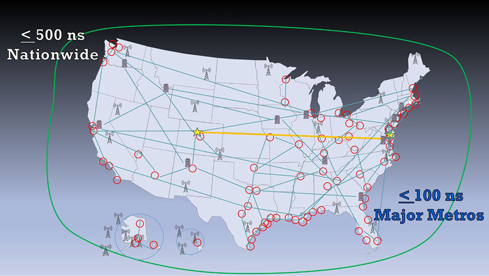
serving the entire U.S. land area, airspace, and coastal waters to about 200 miles offshore
enabling all fixed and mobile users to access at least one non-space-based source (to ensure no common failure modes with GPS/ GNSS)
timing accuracy in all locations to within 500 nanoseconds of universal coordinated time (UTC); this accuracy should be within 100 nanoseconds of UTC for the 50 largest metropolitan areas
one or more integrity measures to provide users confidence in system(s) accuracy
a very high rate of continuity and availability, similar to that of navigation beacons for aircraft
a performance monitoring and control system.
Evaluation Criteria
Fortunately for the government, numerous systems and companies are already able to provide the needed services. Deciding which to select will likely be a significant effort. Some of the evaluation criteria suggested by the RNT Foundation white paper are:
Annual Cost – While cost will not be the only consideration in this acquisition, the government always has a responsibility to taxpayers to weigh it as an important factor.
Infrastructure Required Per Unit of Coverage Area – This has been cited by the Department of Transportation as a very important consideration. Not only does the amount of infrastructure affect cost, but it also has implications for environmental and community impacts.
Spectrum – Signal disruption by in-band and out-of-band transmissions has been a significant issue for GPS. New PNT wireless and radio-frequency services should pose as few spectrum concerns as possible. Spectrum band reservations, licenses, pre-allocated bands, other bands and adjacent band uses will all be given consideration.
Penetration – While the government may not list this as a requirement, the ability of a service to reach underwater, underground and indoor locations will likely be desirable and part of proposal evaluation.
Resilience – The vulnerability of GPS signals to disruption will undoubtedly make the resilience of potential backup and complementary systems a major issue. The RNT Foundation paper discusses two kinds of resilience – operational and recovery.
Operational resilience is defined as “the ability of a system, combination of systems, or service to resist disruption (e.g.: jamming, spoofing, physical damage negatively impacting service).” One measure of resilience might be the energy needed to disrupt signals.
Recovery resilience is described as “The speed and ease with which a service can return to normal operation” after a disruption.
Cybersecurity – Similarly, cybersecurity is seen as having two components. The first is network security, defined as the degree to which systems are isolated from or connected to networks. Second is signal security, and is how well signals can be protected from infiltration and imitation.
Endorsements for GPS Alternative Timing
Since the “National Resilient Timing Architecture” white paper was issued in 2020, calls for GPS alternatives have intensified, and the white paper itself has received an important endorsement.
On May 7, the telecommunications industry standards group Alliance for Telecommunications Industry Solutions (ATIS) vigorously supported federal funding for GPS alternatives. In letters to leaders in both houses of Congress, ATIS cited “the urgent need for funding the deployment and adoption of Alternative Positioning, Navigation, and Timing (PNT) Systems in U.S. critical infrastructure, including the U.S. telecom industry.”
The need for federal support for timing and positioning backups for GPS was also supported by a two-year old study released by RAND Corporation in May. While the paper went to great lengths to argue against a duplicate GPS-like capability (something no one has supported to the best of our knowledge), it quietly suggested federal support for both a national timing system and location services to serve E-911 systems.
Numerous recent media releases from U.S. Space Force have revealed serious military threats to GPS and other space-based systems. A variety of killer-satellites, lasers and other weapons have turned space from a sanctuary into a potential battle ground. While not specifically calling for alternatives to GPS, the Space Force announcements have made it clear the nation needs to “get the bullseye off GPS.” Establishing at least one terrestrial alternative system similar to those operated by our adversaries will make U.S. satellites and signals much less attractive targets, according to Greg Winfree, former assistant secretary at the U.S. Department of Transportation.
Federal Funding Needed
Federal funding for improving national timing was specifically supported by a group of CEOs and senior executives from major telecom companies. Acting as the National Security Telecommunications Advisory Committee (NSTAC), the group’s May report to President Biden discussed GPS vulnerabilities and threats, and urged establishment of a capability
“…similar to that reflected in the Resilient Navigation and Timing Foundation’s paper entitled A Resilient National Timing Architecture. Further, to enhance the ability of commercial entities to afford leveraging this architecture, the Administration should appropriate sufficient funds to lay the foundation for creating this timing architecture, with the Federal Government being the first customer for what will ultimately become a resilient, interconnected network for PNT delivery.”
Federal funding support is necessary, according to NSTAC, because free GPS services greatly suppress market demand for alternatives.
Mitigating intentional interference for satellites is addressed in a new white paper released by Intelsat General.
The white paper details interference mitigation on the Intelsat EpicNG platform. Intelsat General is a wholly owned subsidiary of Intelsat and operator of the worldwide Globalized Network.
The whitepaper validates the ability of the Intelsat EpicNG platform to mitigate attempts by adversaries to intentionally interfere with signals operating on Intelsat’s multi-spot, high-frequency reuse, high-throughput satellites. This is particularly important for U.S. and allied military forces in hostile theaters throughout the globe.
“U.S. DoD (Department of Defense) satellite communication systems are critical for collecting and disseminating video and data that give the military real-time information about a hostile environment,” said Skot Butler, president of Intelsat General. “Our Interference Resolution demonstration showcases the capability of the Intelsat EpicNG system, and its advanced digital payload, to work around efforts to interfere or jam the signals being transmitted via our satellites.”
https://youtu.be/B0rhVk4MYY0
Demonstration. The Interference Resolution demonstration used a remote terminal transmitting video to a hub Earth station over the Intelsat 29e satellite. During the validation process, technicians transmitted an interference signal on the same channel used to transmit the video.
Once the interference was detected, technicians were able to reconfigure the satellite and the remote terminal, thereby re-establishing video transmissions. The reconfigurations
terminated the interferer at the satellite thereby clearing the downlink,
provided a new, interference-free uplink channel, and
connected the new video uplink channel to the original, now clear, downlink channel.
Intelsat 29e, launched in January 2016, was the first of Intelsat’s fleet of high-throughput satellites. Five Intelsat EpicNG satellites are now in orbit with one more planned for launch in 2018.