Hexagon AB, which offers digital-reality solutions combining sensor, software and autonomous technologies, will integrate AVVIR’s artificial-intelligence-powered technology stack into its portfolio of solutions that address challenges of the construction lifecycle.
Since 2017, AVVIR has enabled intelligent, data-driven job sites that empower commercial, infrastructure and industrial construction professionals to reliably and safely deliver on schedule and within budget, Hexagon stated in a press release.
AVVIR’s reality-analysis platform is focused on building information modeling (BIM). It is designed to improve project workflows, schedules and outcomes by leveraging onsite reality-capture data, enriched BIM models and artificial intelligence. The solution gives construction teams control with automated schedule tracking, cost and earned value analysis, installation issue detection, and an updated BIM with as-built conditions.
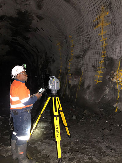
Trimble has introduced its SX12 Scanning Total Station, the next iteration of its 3D scanning total station that provides fast and efficient data capture for surveying, engineering and geospatial professionals.
New features include a high-power laser pointer and high-resolution camera system, expand capabilities in surveying, and complex 3D modeling. The SX12 enables enable new workflows in tunneling and underground mining, Trimble said.
The Trimble SX12 merges high-speed 3D laser scanning, Trimble VISION imaging technology and high-accuracy total station measurements into familiar field and office workflows for surveyors.
A new green, focusable Class 1M laser pointer — safe for viewing with the naked eye — offers high-power visibility and makes it easy to see at a distance. An improved camera system provides enhanced pointing and site documentation capabilities.
“The new SX12 adds more features and applications to an already widely adopted, field-proven scanning total station,” said Gregory Lepere, marketing director of Optical and Imaging for Trimble Geospatial. “The addition of a premium laser pointer completes the picture for surveyors wanting an instrument that can operate as an everyday high-end total station with the added value of scanning and imagery.”
Tunnels and underground mining
The Trimble SX12 allows users to quickly and easily operate with common survey workflows, including new versions of Trimble’s field and office software.
With Trimble Access 2021 Field Software, users can harness the full potential of the Trimble SX12, whether performing accurate measurements or comparing 3D scanning as-built data in the field. The combination is designed for infrastructure projects such as utilities, roads, rail, water, transportation and telecom.
The laser pointer enables new applications for laser-guided drilling and excavation guidance, rock bolt and blast hole set out, and as-built verification for underground tunnel and mine construction.
By integrating rich data from the Trimble SX12 into intuitive office workflows, Trimble Business Center version 5.40 enables users to quickly create complete customer deliverables. With its enhanced point-cloud management, eCogAI automated information extraction, and interoperability to leading CAD and GIS packages, the solution empowers users to exceed even the toughest client demands.
The combination also enables the capture of tunnel point clouds for as-built comparison, automated tunnel extraction routines and detailed 3D mesh inspection resulting in intuitive reporting deliverables for construction verification.
“Tunneling projects are highly dependent on accurate positioning to precisely control equipment and track progress in difficult underground construction environments,” said Boris Skopljak, marketing director of Monitoring and Tunneling for Trimble Geospatial. “The combination of the SX12 and new software workflows, simplifies the capture of site conditions, enabling tunneling and mining surveyors to make accurate and informed decisions without the complexity and additional cost of multiple systems.”
This powerful new capability assists organizations in the engineering, environmental consulting, construction and public utilities sectors that use custom mobile data collection apps built with Flowfinity to survey and inspect work sites.
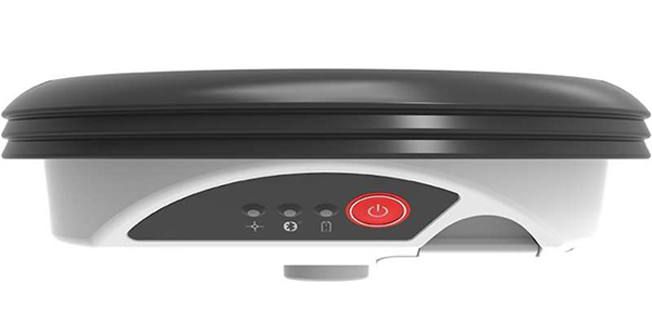
The Zeno GG04 plus is a rugged, flexible and easy-to-use smart antenna from Leica Geosystems, part of Hexagon. It uses RTK technology and Precise Point Positioning (PPP) to make high-accuracy data collection possible in real-time even in demanding locations without the need for a mobile data connection.
Photo: Flowfinity
The combination of state-of-the-art Zeno GNSS technology with the workflow automation features in Flowfinity Actions is a game-changing update that will save hours in the field while providing location data accurate to five decimal places for analysis in the office.
“This is an exciting update for any organization that needs to record accurate site survey data as part of their digital mobile workflows,” said Larry Wilson, VP Sales & Marketing, Flowfinity. “Field users in engineering and related industries can now collect some of the most precise GNSS readings possible and have that info available in their existing Flowfinity applications. This opens up significant opportunities to become more efficient on-site.”
All Flowfinity applications deployed on Android and iOS devices can now leverage the Leica Geosystems antenna to achieve 5 decimal place accuracy for GNSS location data.
For example, if an environmental consulting firm needs survey quality GNSS data to be collected and submitted during site inspections, they can now deploy field workers with Leica GG04 plus Smart Antennas to record data directly into their Flowfinity mobile applications, rather than performing manual data entry or relying on much less precise data from internal mobile device sensors.
Flowfinity is used across industries including environmental services, engineering, construction, municipal governments and utilities for driving efficiency and streamlining operational workflows.
SimActive Inc., a developer of photogrammetry software, has launched an automated solution for direct georeferencing from real-time kinematic (RTK) positioning.
Within the new workflow feature, users can achieve get high accuracy in projects without the use of ground control points (GCP), saving time in collecting and processing data.
Martin Instrument, a reseller of SimActive and surveying equipment, is benefitting from the automation. “Direct georeferencing greatly helps reducing cost for applications like corridor mapping,” said Mike Minick, vice president of sales at Martin Instrument. “The new automated option within SimActive software for direct georeferencing greatly facilitates the user workflow.”
“With RTK GPS available on drones, the use of direct georeferencing is growing within the industry,” said Louis Simard, CTO of SimActive. “Correlator3D allows users to maximize their hardware and software investment.”
For a live demonstration at the Commercial UAV Show (Nov. 15-16, London, United Kingdom), visit SimActive’s booth or send an email to [email protected].
ArcGIS Pro 2.0, Esri’s next-generation desktop geographic information system (GIS), is now available. This latest version provides more highly requested workflows and features new innovations.
It is also more tightly integrated with the rest of the ArcGIS platform, so that users can complete more of their workflows solely in ArcGIS Pro.
Jack Dangermond, Esri president, introduced major features of the upgrade at the Esri User Conference plenary July 10. The Esri User Conference takes place in San Diego July 10-14. Several focused sessions at the conference will explore the updates to ArGIS Pro.
Highlights of ArcGIS Pro 2.0 include the following.
Workflows
The user’s favorite workflows are now easier and more powerful in ArcGIS Pro 2.0. Users can perform more complete workflows solely in ArcGIS Pro, such as map creation and data management.
Create more effective and meaningful maps with annotation and grids.
Getting started with new ArcGIS Pro projects has vastly improved with Favorites.
Modify topology properties directly in ArcGIS Pro.
Enhanced traverse tool improves COGO workflows.
Highly requested context menu options for importing and exporting data included in the Catalog pane.
Users of ArcGIS Pro can now create map notes in 3D in a scene.
Innovations
ArcGIS Pro 2.0 features the following innovations.
Explore 3D landscapes with new 3D navigation controls, and sync the views of 3D and 2D maps.
Layouts are more useful and powerful with embeddable dynamic interactive charts.
Improvements to 3D drawing including feature drawing by camera distance and enhanced lighting of 3D objects make 3D visualizations even better.
Analytics improvements with fill-missing-values tools and enhanced spacetime cubes.
Get more done with new geoprocessing tools.
ArcGIS Platform Integration
ArcGIS Pro 2.0 works better with the rest of the ArcGIS platform, including ArcGIS Online, ArcGIS Enterprise and Esri’s library of ready-to-use apps. Cross-platform workflows are now easier and more powerful than ever.
Enhancements for editing and interacting with the geodatabase in the ArcGIS Pro 2.0 SDK.
Consume native OGC Web Feature Service (WFS) Services directly in ArcGIS Pro.
Sync with feature layers that reference data registered in Portal for ArcGIS 10.5.1.
Vertical coordinate systems are included when sharing web scenes and web scene layers.
Continue to work in ArcGIS Pro while packaging operations complete in the background.
Get the full details on what’s new in ArcGIS Pro 2.0.