Precise Point Positioning (PPP) has long held promise as a standalone, high-accuracy positioning technique, but its slow convergence and complexity in ambiguity resolution have limited widespread use. Over the past decade, GNSS modernization (GPS, Galileo and BeiDou) has introduced multi-frequency, high-precision signals, enhancements that expand opportunities for precise positioning.
Yet challenges remain, especially in environments with obstructed views or fast-changing motion. High-fidelity corrections and real-time performance are critical for sectors like smart transportation, robotics and disaster response.
Further in-depth research is needed to refine PPP solutions and meet the demands of real-world, dynamic applications.
A collaborative research team from Wuhan University and affiliated institutions has published a major study in the July 2025 issue of Satellite Navigation. The team developed and validated an enhanced PPP and PPP-RTK framework using next-generation GNSS signals and satellite augmentation services.
The study evaluated the performance of BDS-3’s PPP-B2b and Galileo’s HAS services across a variety of experimental settings, revealing dramatic improvements in positioning accuracy, convergence time, and reliability.
These breakthroughs offer a practical roadmap for deploying real-time high-precision navigation at global scale.
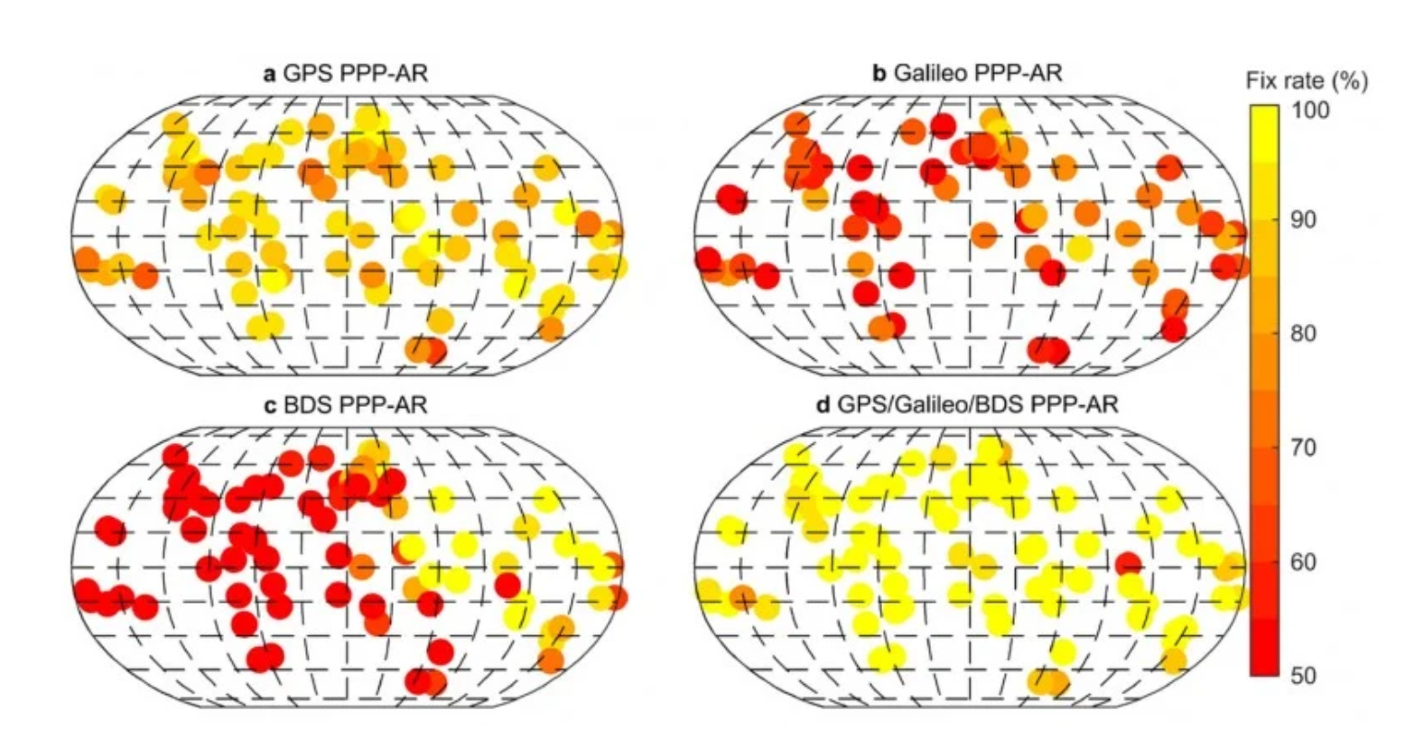
The researchers constructed an integrated precise point positioning with real-time kinematic (PPP-RTK) system incorporating real-time atmospheric corrections, observable-specific bias (OSB) products, and multi-constellation satellite data. Through extensive global experiments, they demonstrated that a combined GPS/Galileo/BeiDou configuration reduced static convergence time to under 5 minutes while achieving horizontal accuracy below 2 cm. In dynamic tests — including a real-world vehicular trial in Wuhan — PPP-RTK achieved sub-5 cm accuracy with instant or near-instant convergence, even under rapidly changing observation environments.
These systems proved especially effective when paired with atmospheric modeling techniques like Kriging and distance interpolation. With fix rates exceeding 98%, the results underscore PPP-RTK’s readiness for mission-critical applications in rapidly changing environments.
Additionally, the study evaluated augmentation services: the BeiDou PPP-B2b and Galileo High Accuracy Service (HAS). Both were found to significantly accelerate convergence (to under 15 minutes and 100 seconds, respectively) and deliver decimeter-level accuracy in kinematic scenarios.
“This study marks a turning point in the quest for real-time, high-accuracy positioning,” said Xiaodong Ren, lead author and professor at Wuhan University. “By merging advanced GNSS signals, atmospheric corrections, and real-world testing, we’ve demonstrated that PPP-RTK can deliver fast, stable and highly accurate results — even in the most demanding environments. These capabilities are essential for the next generation of autonomous systems, from self-driving cars to drones and beyond.”
The ability to achieve centimeter-level positioning accuracy quickly and without reliance on dense base station networks opens doors for a wide range of smart technologies, Xiaodong said. PPP-RTK has the potential to reshape industries such as precision agriculture, surveying, transportation logistics, and unmanned systems.
This study provides a robust framework and empirical validation for real-world adoption of high-precision GNSS applications, according to the authors. “As satellite constellations and augmentation services continue to evolve, PPP-RTK is poised to become the foundation of global positioning solutions — reliable, scalable, and ready for deployment in tomorrow’s connected world,” Xiaodong said.
On Sept. 23, the China BeiDou Application Conference and the Ninth Annual Conference of China Satellite Navigation and Location Services were held in Wuhan, according to a press release from haiwainet (People’s Daily), an official Communist Party newspaper of China.
Attending the conference were 700 experts, officials and entrepreneurs, as well as company representatives from BDStar Navigation, Amap, Allystar, Unistrong and Wuhan Exsun. “Delegates agreed that China’s BDS PNT (positioning, navigation and timing) industry has just started and is ushering in a golden decade of rapid growth,” the press release stated.
Zhou Xianwang, mayor of Wuhan, said that Wuhan, an important city for BDS construction and industrial development in China, is accelerating Beidou industry innovation, application promotion and enterprise development with first-class talents and services, and striving to make Wuhan a new highland for Beidou industry innovation and development.
Yu Xiancheng, president of the GNSS and LBS Association of China, said the Beidou industry in China has reached about $58.8 billion and the industrial ecology has taken shape.
According to the press release, “China’s Beidou is the first-class Beidou and the world’s Beidou as well. The application and space-time services of Beidou technology will become more popular in China and the world, ushering in a golden decade of development.”
BDS basic products have been exported to more than 120 countries and regions, and Beidou-based land ownership confirmation, precision agriculture, digital construction and smart ports, etc. have been successfully applied in ASEAN, South Asia, Eastern Europe, West Asia and Africa.
GPS technology is doing far more than helping us navigate or receive accurate time. It is now being used to fight the spread of the global COVID-19 pandemic.
Global navigation satellite systems are being used to collect big data on travel and contact, but they are also being used in more unconventional ways: for example, quarantine enforcement and sanitation technology.
Read on to learn about a few recent developments in the world of GNSS/GPS that are bolstering the battle against the novel coronavirus.
Electronic monitoring enforces quarantine
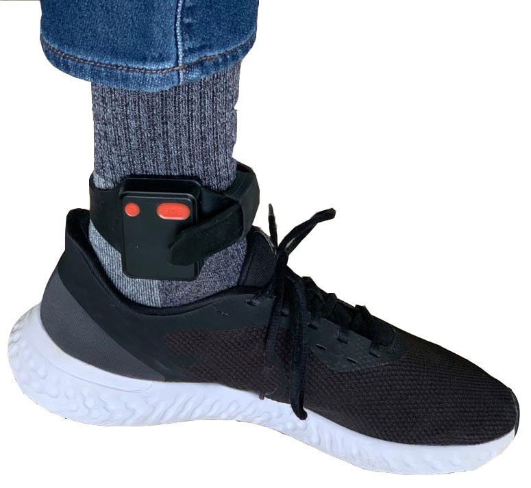
There is a surge of applying ankle monitors to track sick individuals and deter them from spreading the virus further. According to BloombergBusinessweek, one business is thriving because of it: providers of electronic ankle monitors.
Kentucky courts are requiring GPS ankle monitors for people who test positive for COVID-19 and refuse to self-quarantine. Kentucky couple Elizabeth and Isaiah Linscott were two of a growing number of people placed under house arrest after Elizabeth tested positive for COVID-19 and denied signing the Self-isolation and Controlled Movement Agreed Order, a health department document promising she would stay home.
Photo: Regulus Cyber
Elizabeth told Louisville television station WAVE 3 News that she did not sign because she disagreed with the wording of the document. She said that she was concerned about having to contact the health department before traveling, even in the case of an emergency.
“My part was if I have to go to the ER, if I have to go to the hospital, I’m not going to wait to get the approval to go,” she said.
A few days after Elizabeth refused to sign the paperwork, her husband opened their door to an entourage of law enforcement officers serving them with a Health Department order to wear ankle monitors.
“I open up the door, and there’s like eight different people, five different cars, and I’m like ‘what the heck’s going on?’ This guy’s in a suit with a mask. It’s the Health Department guy, and they have three papers for us. For me, her and my daughter,” Isaiah said.
The Linville family is now confined to a 200-foot radius. If they leave their designated quarantine area, their ankle monitors will alert law enforcement.
Alternative to prison
The number of people on house arrest in the United States and across the world has surged as corrections departments struggle to slow the spread of the coronavirus within prisons. An estimated 25 to 30 percent more people are wearing ankle monitors in comparison with a few months ago, according to Bloomberg Businessweek. The U.S. Federal Bureau of Prisons reported a 160 percent increase in home confinement from late March to July. European corrections departments have similarly put thousands of inmates on house arrest in the last few months.
“Demand has spiked everywhere,” BI Inc. monitoring equipment executive Robert Murnock said to Bloomberg. “We’re getting calls from different jurisdictions and other countries we’ve never worked with.”
Efforts to reduce crowding in prisons mean that the electronic monitoring industry is one of very few industries benefiting financially from the coronavirus pandemic.
“Coronavirus gives electronic monitoring companies an opportunity like they’ve never had before to expand,” parole reform expert James Kilgore said.
On Aug. 3, Singapore announced the rollout of electronic tracking devices to enforce quarantine. Travelers will be required to wear GPS and Bluetooth-powered tracking devices that notify authorities if quarantine is broken or the device is tampered with. The rule went into effect on Aug. 11 and applies to all incoming travelers — resident or nonresident — over the age of 12.
On Aug. 20, the premier of Western Australia, Mark McGowan , said his government could soon force people in hotel quarantine to wear electronic monitoring equipment if they are deemed a risk. “If we identify people who are potential flight risks or who might have a criminal history, we are looking at applying monitoring bracelets to them,” he said.
An estimated 25 percent to 30 percent more prisoners are wearing bracelets now compared to the pre-outbreak period. In the U.S., the Federal Bureau of Prisons has placed about 4,600 inmates in home confinement, a 160 percent increase since the end of March.
“Demand has spiked everywhere,” said Robert Murnock, vice president for partnership development at BI Inc., a provider of EM technology.
The emergency shift to electronic monitoring spurred by COVID-19 may foretell a long-term shift toward use as an alternative to prison time, reducing clutter and the risk of the virus spreading among inmates.
Photo: LeoPatrizi/E+/Getty Images
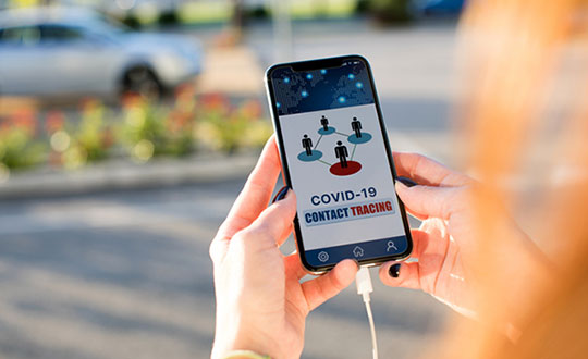
Contact tracing via mobile phones
Israel is using covert mobile phone data to track the spread of COVID-19. On July 1, the Knesset approved a bill temporarily reauthorizing mass surveillance of coronavirus-infected citizens by the Shin Bet, Israel’s internal security service. The original program lasted from mid-March to June 9.
The contact-tracing program works like this. When a patient is diagnosed with COVID-19, the Israeli Health Ministry provides their personal information — including their mobile number — to the Shin Bet. The Shin Bet then consults a classified database of every person who uses Israeli telecom services to determine who came into contact with the infected individual for more than 15 minutes at a time. After the Shin Bet sends information back to the Health Ministry, the Health Ministry notifies those people via text and tells them to self-quarantine.
The Shin Bet’s newfound role in public health enforcement is quite different from its usual focus. Former Shin Bet agents say the COVID-19 mobile phone tracking technology was originally developed as a counterterrorism measure, and the tracking system being used on Israeli civilians is almost identical to that used for suspected terrorists.
“It’s the same system, the same methods,” retired Shin Bet agent Arik Brabbing said to BBC. “We know that someone was here in the park. We can get from the [mobile phone] company all the details about the hour, the place, exactly the place… and we can understand who else was around.”
Supporters of the mass surveillance program, including Prime Minister Benjamin Netanyahu, argue that reduced privacy is necessary to curb the spread of the virus. However, the Israeli government has come under fire by opponents who claim that the program is intrusive and undemocratic.
Israel’s contact tracing procedures are more secretive than those of South Korea and Taiwan, other countries that mandate central mass surveillance. South Korea and Taiwan both enforce quarantines with mobile-phone tracking, and both have built publicly available COVID-19 data platforms.
The South Korean government has disseminated detailed — but anonymized — information about COVID-19 carriers, including their travel routes and treatment facilities. Citizens broadly support these measures — a testament to collectivism in Korean culture.
Civic engagement and enthusiasm for fighting the pandemic is also remarkable in Taiwan, where the public has been collaborating with the government on a town hall-style website called vTaiwan. Citizen-led initiatives, like a GPS-powered tool for tracking face mask supplies, have been applied nationwide.
Meanwhile in Europe, eight major telecom companies, including Vodafone and Orange, have been supplying anonymized metadata to the European Commission to model and predict the spread of the virus. In the United States, the Centers for Disease Control and Prevention is soliciting GPS data from mobile advertising companies rather than carriers themselves.
The two tech giants, Apple and Google, made it easier for health agencies to join its coronavirus exposure notification system, creating a new built-in app within iOS and Android. The app provides real-time notification to users when they are exposed to a sick person.
Virus-killing robots may roam the streets
GPS-based robots, drones and autonomous cars are being deployed to sanitize outdoor spaces, transport medical equipment, and announce safety information to the public.
Robots began rolling around the streets of Wuhan, the original epicenter of the coronavirus outbreak, as early as January. China was the first to deploy robots of this type, but India, Spain, France and other countries have followed in their footsteps. In addition to the chemical-spray approach, some companies are pioneering mobile disinfection robots armed with large ultraviolet-C germicidal lights.
Apollo, the autonomous vehicle company of multinational internet giant Baidu, has partnered with Chinese self-driving startup Neolix to transport food and supplies to Beijing Haidian Hospital. Every morning at 10:30 a.m, an unmanned car delivers meals to about 100 frontline workers. The process eliminates direct contact, protecting the safety of food service workers, hospital staff, and patients.
Zhangjiang Artificial Intelligence Island
A fleet of Apollo and Neolix’s unmanned cars is also responsible for disinfecting all roads on Zhangjiang Artificial Intelligence Island, an 100,000-square-meter industrial complex in Shanghai. The vehicles are loaded with up to 160 liters of spray disinfectant and can cover the island’s entire road system in about half an hour.
The vehicles at Zhangjiang AI double as nighttime surveillance bots. They patrol the island and make sure that guests are adhering to coronavirus protocols, alerting security personnel if they note suspicious activity.
In addition to using drones to spray disinfectant, South Korea’s government has leveraged the technology for public announcements. On July 4, 300 drones lit the sky above Seoul in a show of appreciation for frontline workers. The drones executed a 10-minute synchronized show that included images of face masks, hand washing, and social distancing.
Summary
As COVID-19 continues to ravage the globe, governments rely on GPS to track the virus, contain it, and fight against it. The battle against coronavirus is still being waged on a global scale, utilizing GPS as a weapon along with many other existing technologies.
The pandemic changed the world forever, and it also highlighted the power of tracking and monitoring location of people and machines. It is another testament to the immense reliance on GPS technology in our modern world.
The increased deployment of these technologies necessitates increased security measures, especially when public health is on the line. Regulus Cyber offers GPS Cybersecurity software. To read more about it, visit www.regulus.com.
Through its group company Antwork, Japanese company Terra Drone is employing its UAV system to transport medical samples and quarantine supplies in China to fight the coronavirus.
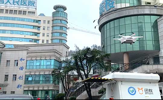
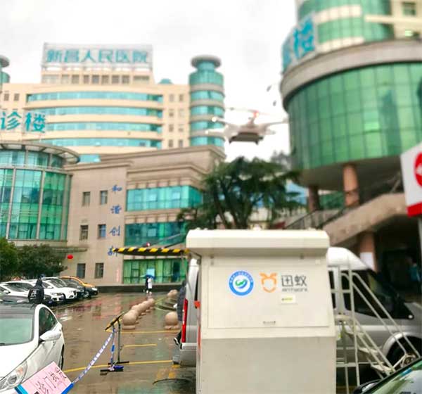
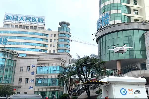
At 9 a.m. on Feb. 6, a medical delivery drone flew from the People’s Hospital of Xinchang County to the disease control center of Xinchang County, marking the launch of the first urban-air transportation channel to help to fight the novel coronavirus (COVID-19 ), a global health emergency.
Take off and landing point of Xinchang people’s Hospital. (Photo: Terra Drone)
The World Health Organization reports at least 95,270 people are infected and at least 3,280 have died. China, where COVID-19 originated, is in a tense period of epidemic prevention and control. Xinchang County is in Zhejiang province — one of the areas most severely hit by the virus.
As soon as the Wuhan quarantine began on Jan. 23, Antwork petitioned to provide drone technical support.
Antwork’s RA3 and tr7s drones and unmanned RH1 station are ensuring that medical samples and quarantine materials can travel with minimal risk between Xinchang County People’s Hospital and Xinchang County’s disease control center. The automatic, unmanned air delivery system significantly reduces contact between samples and personnel, as well as improves delivery speed.
Antwork branch company Aerodeli, which undertook the operation, obtained the first urban drone delivery license issued by the Civil Aviation Administration of China (CAAC) in October 2019. The sample delivery work is carried out in strict accordance with certified operation procedures to ensure the safety of medical samples during transportation.
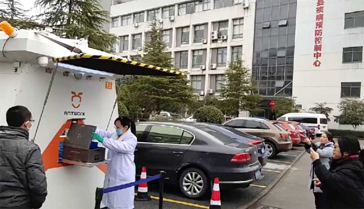
Take off and landing point of disease control center of Xinchang County. (Photo: Terra Drone)
Using drones has increased the speed of transport by more than 50% compared to road transportation, proving to be a more efficient means of transportation for epidemic prevention and control. The drones also relieve the personnel shortage as more and more medical staff and ambulances are transferred to the front lines — making the best use of human and material resources.
After the project for Xinchang People’s Hospital was put into operation, Antwork began assisting more medical institutions in China to deploy drone transport services for the anti-epidemic effort.
A drone departs from the disease control center of Xinchang County. (Photo: Terra Drone)