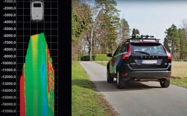
Multi-sensor clusters enable precise assessment of road conditions. (Photo: XenomatiX)
The success of higher levels of vehicular autonomy will depend on two types of roadway corridor digital twins: pre-mapped and augmented on the fly. No matter how well the corridors are pre-mapped, there will always be the need for the vehicle to be self-aware — not only of the proximity of other vehicles and pedestrians, but also of changes to fixed features. New vehicles are being provisioned with multi-sensor clusters, including GNSS, cameras, lidar, sonic and more. This provides an opportunity to more precisely assess the condition of the road surface, which affects the performance of vehicle suspension systems, tires, fuel efficiency and general wear and tear.
“Imagine that your car navigation map system included roadway conditions,” said Karsten Bronowski, sales and business development manager for XenomatiX, “a global view where roads are color-coded based on their surface types and roughness. And all of this is mapped by systems like ours or added to the mobile systems mapping all the roads.
“Our product actually came out of the automotive world, and we still have customers that use it as a reference system for active suspensions, for mass-spring damping systems,” Bronowski said. For these applications, the sensors were mounted facing forward for a preview mode. “We have worked with the Belgian Road Research Center and others with applications to readily provide the international roughness index.”
XenomatiX was formed in 2013, focused on developing true solid-state lidar. “The idea was to get the motor out of lidar,” said Bronowski. “You have moving parts, you have wear and tear, the effects of vibration, problems with long-term reliability and with controlling temperature. With true solid-state lidar, you eliminate these issues.” Micro-electromechanical systems (MEMS) lidar systems still have moving, opto-mechanical components. Bronowski said that the solid-state systems feature a CMOS-based detector generating high-density point clouds in all weather conditions, and a multi-beam laser projector generating a high-resolution grid of points.
The dual lidar sensor system gets its orientation and positioning from additional components, including GNSS and IMU. The system that Bronowski showed at Intergeo 2022 had Septentrio AsteRx-U3 GNSS/IMU units supporting dual antennas for heading. However, they are using other means to improve both relative and absolute positioning: “How we do this is one of our secrets. For one of our customers in Japan mapping local highways, we proved to have excellent compensation, even tracking precisely through a 4-kilometer-long tunnel.”
XenomatiX has developed software to analyze data for many applications, automate feature recognition, and even validate other data. For instance, one customer in the United States is a big player in the satellite imaging sector that wants to match that data with pavement markings the XenomatiX system picks up.
While there is a needed calibration step and the requirement to align the detector for the dedicated measurement vehicle, sensor systems such as this can be put on just about any type of vehicle — on- or off-road. The driver does not need to intervene much, and the processing is done on a standard PC or laptop. “The customer does not care about the systems, just the data that comes from it,” Bronowski said.
For navigation and control of any robotic or autonomous outdoor system, GNSS and inertial navigation systems (INS) are key components. Inevitably, the question arises: Should you build your own custom solution or integrate an available GNSS/INS combined solution? What would give you the best performance, while keeping the total cost of ownership (TCO) to a minimum? The TCO is also known as the “long-term price” and is defined as the purchase price plus the costs of operation over time.
Xenomatix is a company offering automotive solutions based on lidar technology. With eight years of innovative experience, Xenomatix has installed a pre-integrated GNSS/INS receiver on its latest lidar product, achieving high GNSS/INS performance with minimal TCO.
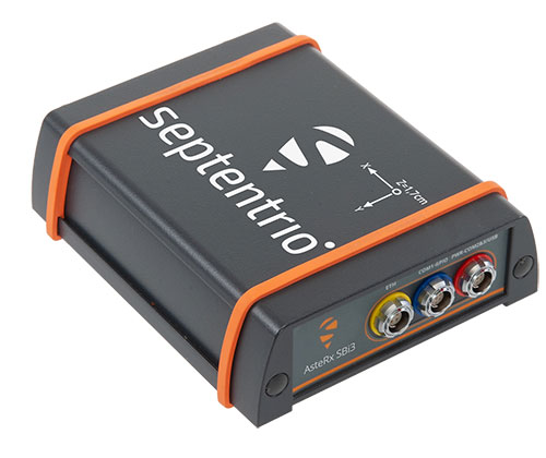
In an integrated INS/GNSS receiver, the GNSS receiver provides positioning with centimeter-level accuracy. The other component is a micro-electromechanical inertial measurement unit (MEMS IMU), which measures 3D orientation in terms of heading, pitch and roll angles with sub-degree precision. For its latest product XenoTrack, Xenomatix chose an INS called XenoAsterx based on the AsteRx SBi3 from Septentrio, which it integrated alongside its lidar to collect road-quality data to the smallest detail.
From an in-house solution to a pre-integrated system
Three years ago, when Xenomatix started developing its new lidar road-inspection system, the company had a GPS receiver, an IMU and an odometer as accompanying sensors. The company wanted to expand into new markets of road inspection in accordance with international standards, and so it needed to improve its components to take the overall performance of its system to the next level with RTK high-accuracy positioning.
To achieve this, while saving time and costs, Xenomatix acquired an AsteRx SBi3 INS/GNSS receiver, which allowed it to focus on its core lidar technology and sensor-fusion algorithms.
This off-the-shelf INS/GNSS solution provided all the high-accuracy positioning and orientation information Xenomatix needed, while eliminating most costs of development, maintenance and support. The new receiver allowed them to drive for miles, without any offset in positioning, something impossible with the previous GPS receiver.
The unique technology from Xenomatix stitches images by using lidar point-cloud overlays. However, when the car is moving fast, this overlay is smaller. The pre-calibrated GNSS/INS extends system performance by allowing stitching even when driving at higher speeds.
“If we start driving and we stitch the road for tens of kilometers and we come back to the same starting point, then we see an offset of only a few millimeters,” said Filip Geuens, CEO, Xenomatix. “This is for us the strongest proof of accuracy and reliability of the GNSS sensor.“
Why pre-integrated GNSS/INS offers better value
The pre-integrated GNSS/INS allows XenoTrack to collect road data even at higher speeds. (Credit: Septentrio)
A pre-integrated GNSS/INS solution — versatile enough to fit into virtually any autonomous or mapping system — offers the best value in the long run for the following reasons.
Better performance. The manufacturer of a GNSS/INS solution specializes in fusing the GNSS receiver and the INS in an optimal way. To accomplish this, the sensors are synchronized and their output run through a sophisticated Kalman filter algorithm. The fused device is then fine-tuned for optimal operation under various conditions. Finally, it is extensively tested and validated.
While being used by numerous customers and in varying applications, the GNSS/INS solution proves itself on various levels such as accuracy and robustness. This results in superior performance, even in the most demanding environments.
After installing the AsteRx SBi3 GNSS/INS system, XenoTrack was able to extend its functionality to inspect longer distances of roads at higher speeds. The AsteRx SBi3 operates reliably, even in challenging environments, such as when driving near high cliffs or under bridges.
Less development time and lower costs. When building a system, the development time is usually about one year employing two full-time GNSS/INS specialists. Hardware components need to be integrated and synchronized, while various interfaces and the Kalman filter need to be implemented. Additional features may be developed, such as velocity input as well as tools for validation, before the intricate step of performance fine-tuning. Finally, additional testing efforts are needed for verification and validation of the device.
On the other hand, a pre-integrated GNSS/INS system with easily accessible interfaces and flexible configuration ensures quick installation, meaning the product is ready within weeks.
Lower maintenance costs and support. Certain high quality pre-integrated GNSS/INS receivers are future-proof — ready to use new GNSS satellite signals and services as soon as they become available. An example of such upcoming service is the Galileo OSNMA anti-spoofing authentication.
Some receiver manufacturers such as Septentrio also offer continuous product improvement in the form of free firmware updates. A system developed in-house, on the other hand, needs continuous investment to maintain its competitive edge.
When issues occur, Septentrio also offers local worldwide support, with experienced application engineers ready to solve GNSS, INS or coupling issues that could halt the production process. For example, when Xenomatix discovered that its GNSS/INS was not working optimally in a certain environment, the company called Septentrio. Within days application engineering experts who analyzed the logged data found the source of the issue and proposed a solution.
Focus on core technology. When the budget is limited, choices need to be made about where to focus the efforts. When a company saves on GNSS/INS development, more can be invested in core technology. This means avoiding any lost-opportunity costs and optimizing margins.
Building your own is not always the best option
Acquiring a pre-integrated GNSS/INS receiver allowed Xenomatix to have a superior and affordable product with a competitive edge. AsteRx SBi3 increased the performance of the XenoTrack mapping system, while a short integration period allowed a faster time-to-market.
Xenomatix also benefited from low maintenance costs, keeping overall TCO to a minimum. Since the company was not spending time developing a custom GNSS/INS system, it could focus fully on its core technology. This allowed Xenomatix to take its business to the next level at a high pace.
Award-winning technology
In November 2021, the XenoTrack road scanner, with AsteRx SBi3 inside, was announced a winner of the IRF Global Road Achievement Award for its innovative road scanning and surveying solutions.
AsteRx SBi3 enables highly accurate and reliable 3D mapping solutions based on sensor fusion with lidar
The AsteRx-SBi3 Pro+ in a rugged housing. (Photo: Septentrio)
Septentrio, a leader in high-precision GNSS/INS positioning solutions, and XenomatiX, provider of true solid-state lidar technology for autonomous applications and road management solutions, are starting a partnership enabling high-quality lidar solutions.
XenomatiX will be using the compact and robust GNSS/INS receiver from Septentrio, AsteRx SBi3 Pro+, to provide analysis of pavement conditions geolocated with millimeter accuracy.
Septentrio’s high-quality GNSS/INS will be a part of Xenomatix’ road lidar XenoTrack, used by road surveyors and road management companies. Septentrio’s AsteRx SBi3, a high-performance RTK GNSS/INS receiver with a dual-antenna setup, ensures centimeter-accurate geotagging of the XenoTrack point-cloud frames for relative and global millimeter accuracy over large distances.
Moreover, the GNSS/inertial measurement unit (IMU) integration algorithm enables dead reckoning — continuous positioning in environments of low satellite visibility where GNSS outages occur.
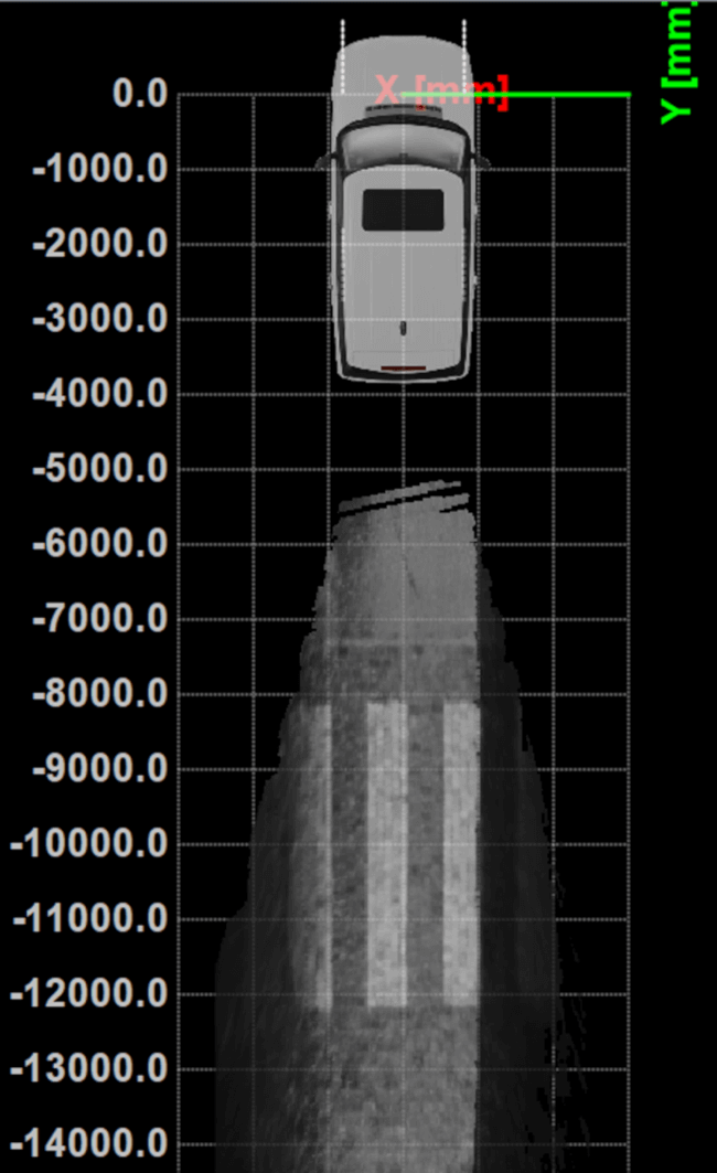
While traditional road scanning based on laser profilers rely solely on extremely accurate GNSS/inertial navigation system (INS) to stitch consecutive profiles together, the XenoTrack captures a 3D topography of an entire area in a single shot. The XenomatiX sensor-fusion algorithms combine visual SLAM techniques with GNSS, IMU and CAN to obtain a seamless map of the road shape.
Septentrio’s proprietary GNSS+ technology plays a key role in delivering the accuracy and reliability needed for XenoTrack. The company’s AIM+ advanced interference mitigation technology ensures robust positioning even in the presence of jammers, which may be aboard vehicles trying to avoid road tolling. When the sky is obstructed for an extended period, the built-in RAIM+ integrity algorithm serves as an indicator of when it is best to give priority to other sensor inputs to maintain a high-quality solution.
XenomatiX offers a complete mapping system as well as services including data from the XenoTrack sensor, camera and real-time kinematic GNSS/INS receiver with dual antenna in an easy-to-install solution on a standard vehicle.