Tag: AUVSI XPONENTIAL 2024

  • GPS jamming at UAV expo

    GPS jamming at UAV expo

    The Baltic, Ukraine, and the Middle East may be hotbeds of GPS interference that can hamper UAV operations, but these are not the only places in the world where it is happening.

    It also happened in San Diego at the premier event for UAV operators— the XPOTENTIAL 2024 conference of the Association for Uncrewed Vehicle Systems International (AUVSI).

    AUVSI is the world’s largest nonprofit organization dedicated to the advancement of uncrewed systems and robotics. Members present included corporations and professionals from more than 60 countries involved in industry, government and academia and work in the defense, civil and commercial markets.

    One of NavtechGPS’ directional finder identifies the source of interference at AUVSI’s Xpotential 2024 in San Diego. (Image: Dana Goward)
    One of NavtechGPS’ directional finder identifies the source of interference at AUVSI’s Xpotential 2024 in San Diego. (Image: Dana Goward)

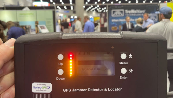
    Among conference attendees were Franck and Trevor Boynton of NavtechGPS, a small Northern Virginia company specializing in GPS products and related services. One of their services is locating devices that are interfering with GPS reception.

    “In our work around the country we have found a wide variety of devices interfering with GPS,” said Franck Boynton. “It’s a lot more common than you think. We found truckers with jammers interfering with port operations, for example,” he said. “But accidental interference is an even bigger problem. Most of the time we find it is just some malfunctioning equipment making the radio noise.”

    Boynton’s experience is consistent with the 2019 European Union STIKE3 sampling project that detected more than 450,000 signals with the potential to interfere with GPS and other satnav signals. Experts determined that only about 10% of those were intentional. The rest seemed to be a byproduct of mechanical and electrical equipment not functioning quite properly.

    Of course, intentional or accidental, interference with GPS signals can be a problem for both manned and unmanned aircraft, vessels and vehicles.

    Intentional interference in conflict areas has turned UAVs and missiles away from their targets, and in some cases, back on attackers. It has impacted the safety and efficiency of aviation and maritime traffic nearby. As one example, regular jamming in the Baltic region recently resulted in the cancellation of scheduled commercial air service to a city in Estonia.

    Accidental interference has caused survey UAVs to crash and created multi-day problems at the Denver and Dallas-Fort Worth major airports.

    In at least one instance accidental interference almost ended in tragedy. In 2019 a commercial passenger aircraft near Sun Valley, Idaho nearly crashed into a mountain. Fortunately, a sharp-eyed radar controller hundreds of miles away intervened and directed the aircraft back on course.

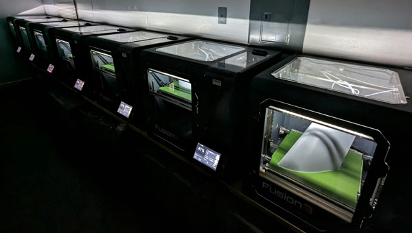
    Nearly 600 vendors filled the AUVSI XPOTENTIAL exhibit hall this year. While perusing the displays, the Boyntons detected a strong signal interfering with GPS frequencies. Thinking it was coming from one of the exhibits, they were surprised to find that not only did it turn off and on but it seemed to be moving around.

    Using one of the direction finders that NavtechGPS sells, they were able to track the source to a film crew roaming the hall and speaking with exhibitors and attendees. The wireless microphone being used for interviews turned out to be the culprit. Since the film crew was unable to repair or replace the mic, the interference continued intermittently inside the hall for the rest of the event.

    “Interference of all kinds with GPS and other satnav signals is a growing problem,” according to Franck Boynton. “As we continue to implement more autonomous systems, it will be increasingly important to ensure they have resilient navigation, and we eliminate as many sources of interference as possible.”

    AUVSI did not respond to requests for comment for this story.

  • RapidFlight launches Mobile Production System

    RapidFlight launches Mobile Production System

    Photo: RapidFlight
    Photo: RapidFlight

    RapidFlight has released its Mobile Production System (MPS), designed for the manufacturing and deployment of UAVs from forward locations.

    MPS can be owned and operated by RapidFlight or used by the US Department of Defense (DOD), its allies and defense contractors as an effective way to mass manufacture UAVs across the globe.

    A single MPS can produce 28 Group 3 aircraft per month — or much higher quantities for Group 2 and/or Group 1. Each MPS unit can be operated independently or in coordination with other MPS units by two trained technicians.

    For example, according to RapidFlight, 2,500 or more Group 3 UAVs of the same or varying designs can be manufactured in a year by deploying as few as eight MPS units. MPS are easily transported by traditional ground, sea or air vehicles.

    MPS uses commercial off-the-shelf (COTS) components for ease of global deployment and compliance with DOD requirements. They are powered via any 110v to 240v AC power source and are designed to function in the same environments in which the warfighter is deployed. MPS can handle wet, dry, hot, cold, clean, and dirty environments with operational limits currently set from -20º F to 130º F and high humidity.

    RapidFlight engineers have optimized the hardware and software technology stack specifically for MPS capabilities to give users the flexibility to quickly deploy new designs or iteratively add additional aircraft capability for constantly evolving needs.

    Additional benefits include a small logistical and operational footprint, a more resilient supply chain and minimized inventory. With multiple MPS units deployed in strategic locations, users can quickly create a distributed and resilient network of UAS production and support even in remote areas and harsh environments.

  • Nearthlab debuts counter UAS technology in the US

    Nearthlab debuts counter UAS technology in the US


    Photo: Nearthlab
    Photo: Nearthlab

    Nearthlab has unveiled its latest counter-unmanned aircraft system (CUAS) technology.

    The system is a high-speed kinetic interceptor UAS that utilizes advanced autopilot algorithms for calculating and tracking precise target trajectories, neutralizing Group 1 and 2 aerial threats with pinpoint accuracy.

    Additionally, Nearthlab has released AiDEN, an autonomous drone designed for diverse operational contexts, including intelligence, surveillance and reconnaissance (ISR) missions, emergency response programs and infrastructure inspections.

    Nearthlab’s solutions, including the CUAS UAV and AiDEN, are manufactured in accordance with the National Defense Authorization Act (NDAA). The company strictly adheres to NDAA standards to ensure that its UAVs meet the federal requirements necessary for immediate deployment in both military and industrial settings in the United States.

  • Hexagon | NovAtel upgrades GNSS resilience and integrity technology

    Hexagon | NovAtel upgrades GNSS resilience and integrity technology

    PhotoPhoto: Hexagon | NovAtel
    Photo: Hexagon | NovAtel

    Hexagon | NovAtel has launched the NovAtel Application Suite Version 2.0, now including GNSS Resilience and Integrity Technology (GRIT). The GRIT Monitor application allows users to observe radio frequency (RF) interference through a comprehensive dashboard to make informed decisions to maintain robust positioning.

    GRIT is RF interference detection and mitigation technology available on all OEM7 GNSS receiver products, including individual cards and enclosures such as smart antennas, PwrPak and MarinePak.

    GRIT Monitor is a RF interference software visualization tool to offer a real-time, at-a-glance interface of all relevant data in a single dashboard view.

    It includes positioning and device status overviews to serve as a mitigation assistant that indicates whether interference is detected. It features an interactive spectrum viewer, which shows all constellations and frequency bands (spectrum and waterfall), and a signal matrix indicating the signal quality and interference status by frequency band and constellation.

    The updated suite also introduces improvements to user interface, firmware compatibility and extends support to include MarinePak among other enhancements. The Manage application, previously known as Setup and Monitor, now supports satellite tracking for L-Band and SBAS and offers a global map view of connected receivers.

    Version 2.0 of the NovAtel Application Suite is designed to assist users in maintaining accurate GNSS positioning by quickly identifying and responding to RF interference. This update is targeted at industries that require precise location data, such as aerial mapping, agriculture and autonomous vehicle navigation.

    To access the new GRIT Monitor application, download NovAtel Application Suite Version 2.0 at https://bit.ly/3weNXbi.

  • Septentrio expands UAV ecosystem for reliable GNSS positioning

    Septentrio expands UAV ecosystem for reliable GNSS positioning


    Photo: Septentrio
    Photo: Septentrio

    Septentrio is closely working with several UAV solutions providers including 3DR, Holybro, ARK Electronics and Systork, resulting in various new products that allow for easier prototyping or integration of the Septentrio mosaic GNSS receiver into UAVs.

    mosaic is a compact triple-frequency receiver leveraging signals from all available GNSS constellations to offer the highest degree of positioning availability, even under challenging conditions. Built-in anti-jamming and anti-spoofing technology protects mosaic against intentional or unintentional interference. A high level of positioning reliability is also required by UAVs, which operate in challenging environments such as around high structures, under foliage or in places of possible RF interference. In addition to collaborations with hardware integrators, Septentrio works closely with the open-source autopilot community including PX4 and Ardupilot, which aims to facilitate a smooth integration process for end-users.

    The recently available products, which are designed to bring reliable high-accuracy positioning to UAVs, include Holybro H-RTK mosaic-H (dual antenna heading), 3DR mosaic-X5 CAN GPS, Systork Linnet mosaic-X5 and ARK mosaic-x5 GPS. These products offer UAV-centered features such as magnetometer, barometer and UAV CAN communication. The integrated mosaic module receives signals from all GNSS constellations and outputs centimeter-level RTK positioning as well as full GNSS carrier raw data

    Dual antenna operation is also supported with mosaic-H for heading and pitch or heading and roll orientation with sub-degree accuracy. Its anti-interference technology AIM+ is designed to protect the system from malicious jamming and spoofing attacks and reduces the risk of self-interference which occurs when nearby electronics like cameras and servos accidentally emit radio signals that interfere with GPS/GNSS.

  • XPONENTIAL 2024 is quickly approaching

    XPONENTIAL 2024 is quickly approaching

    Image: AUVSI XPONENTIAL
    Image: AUVSI XPONENTIAL

    AUVSI XPONENTIAL 2024 will be held April 22 to 25  at the San Diego Convention Center in San Diego, California.

    The event’s key themes include infrastructure and operations, technical research and development, data and analytics, cybersecurity and policy and regulations. The conference will feature keynotes, educational sessions, specialized workshops, and an XPO Hall with more than 30 exhibit categories with technologies across air, land and maritime sectors.

    XPONENTIAL attracts more than 7,500 attendees each year, who attend more than 200 educational sessions as part of the full conference. The current keynote sessions include innovators with diverse perspectives and backgrounds who will speak on pressing topics and address key questions affecting the autonomous community.

    Confirmed speakers include:

    Doug Beck
    Director, Defense Innovation Unit

    Operationalizing DIU 3.0
    Responsible for accelerating the Department of Defense (DoD) adoption of commercial technology through the military, Beck will discuss how defense agencies and industry can collaborate to strengthen national security. This session will be moderated by Courtney Albon, emerging technology reporter for Defense News and C4ISRNET.


    Michael Brasseur
    Chief Strategy Officer, Saab Inc.

    To Create, To Make, To Shape
    Drawing upon his role in implementing Saab’s future capabilities strategy, Brasseur’s presentation will address how individuals and organizations can foster an environment of continuous improvement and advancement.


    Hal Brands, Ph.D.
    Henry A. Kissinger, professor of global affairs, Johns Hopkins School of Advanced International Studies

    Advancing Technologies and Their Role in World Affairs
    Using his knowledge in foreign policy, international relations and security strategy, Brands will help leaders conceptualize strategies to safeguard national interests and organizations to navigate geopolitical challenges.


    Henrik I. Christensen, Ph.D.
    Qualcomm chair of robotics and professor, computer science, director of contextual robotics institute, UC San Diego

    Looking Ahead: Robotics and Artificial Intelligence
    Henrik will explore the future of these technologies and how stakeholders can form strategies that capitalize on emerging opportunities.


    Harry Yeff (aka Reeps One)
    AI Artist and AI for Good Activist

    Undoing a Narrative of Fear
    Yeff, a London-born, neurodivergent artist, will share how we can foster a constructive dialogue on responsibly integrating technologies such as artificial intelligence (AI) and autonomy. His performance art pieces, integrated with AI and voice technology, have been exhibited internationally and garnered more than 100 million online views worldwide.


    Additionally, a Federal Aviation Administration (FAA) Panel titled “Getting to Go,” will cover safety standards, implementation challenges and obstacles to technology development and testing. Panelists include three representatives from the FAA: Timothy Arel, chief operating officer of the air traffic organization, Marc Nichols, chief counsel and Laurence Wildgoose, assistant administrator for policy, international affairs and environment.

    Matt McCardle, head of global regulatory affairs and strategy at Amazon Prime Air will moderate the discussion.

    GPS World staff will be attending the conference. To follow our live coverage, click here.

    More speakers will be announced in the coming weeks. Click here to learn more and register.