OEM
 Narrowband cellular chipset
With integrated GNSS
The ALT1250 narrowband CAT-M1 and NB1 (NB-IoT) chipset includes GNSS functionality. Its extreme level of integration eliminates the need for most external components required to design a cellular Internet of Things (IoT) module. Less than 100 x 100 square millimeters, the ALT1250 module features support for both Release 13 standards — CAT-M1 and NB1. It includes a wideband RF front end supporting unlimited combinations of LTE bands within a single hardware design; a multi-layered and hardware-based security framework; an internal application MCU subsystem; and packaging that enables standard, low-cost printed circuit board (PCB) manufacturing.
Altair Semiconductor, www.altair-semi.com
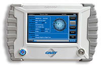
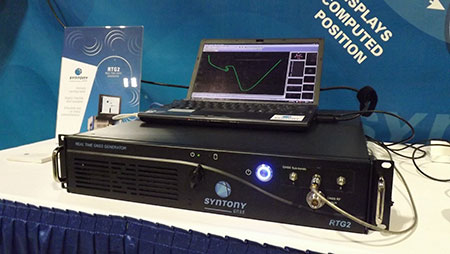
Grandmaster clock
 Carrier-grade, packet-based timing and synchronization
Hardware on the TimeProvider 5000 IEEE 1588 Precision Time Protocol (PTP) grandmaster clock has been updated to support Internet Protocol version 6 (IPv6) and multi-GNSS constellations to ensure better reception and higher security in a wide variety of telecommunications network applications. Looking forward to mobile infrastructure with LTE-Advanced (LTE-A) and 5G services, support for IPv6 and alternate GNSS constellations is rising in importance for deploying a robust, secure and future-proof synchronization network. The device offers multiple constellations in accordance with the directives in certain countries to remove sole dependency on GPS. Support for GLONASS and Galileo also makes systems more robust and secure to certain GNSS vulnerabilities. The TimeProvider 5000 provides redundant hardware, user-configurable PTP profiles and Synchronous Ethernet (SyncE) support with optical small form-factor pluggable (SFP) modules.
Microsemi Corporation, www.microsemi.com
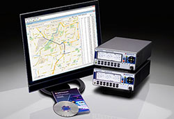
Post-processing board
 Designed for effective data collection, management
The Precis-BX316R is a GNSS Post-Processing Kinematic (PPK) board for accurate positioning. It supports raw measurement output from two antennas: GPS L1/L2, GLONASS G1/G2 and BeiDou B1/B2 from the primary antenna and GPS L1/L2 from the second antenna. The SD card on board (up to 32 GB) makes it convenient for users to collect data for post processing. Working with GNSS antennas, it can output stable measurement in challenging conditions. Integrated with versatile interfaces and connectors, Precis-BX316R aims to facilitate applications such as precision navigation, precision agriculture, surveying and UAV, and enforcing effective GNSS data management.
Tersus GNSS, www.tersus-gnss.com
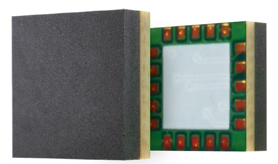
GNSS module
 Integrated module eases embedded designs
The u-blox SAM-M8Q GNSS receiver with integrated antenna is housed in a 15.5 x 15.5 x 6.3 millimeter package. It can be embedded in small devices that require location information, such as asset tracking and telematics systems, and generic automotive after-market applications. The module offers simultaneous reception of GPS, GLONASS and Galileo. The combination of an integrated wide-band antenna along with the module’s SAW filter and low-noise amplifier (LNA) architecture ensures that the SAM-M8Q receiver delivers robust performance in the presence of high-frequency signals from other electronic equipment that can cause interference, such as cellular modems.
u-blox, www.u-blox.com
Dual-band antenna
 Tight pre-filter protects against high-level cell signals
The TW3892 is a through-hole mount dual-band plus L-band GNSS antenna. It employs Tallysman’s Accutenna technology and is capable of receiving GPS L1/L2, GLONASS G1/G2, BeiDou B1, Galileo E1 plus L-band correction services (1213MHz to 1261MHz + 1525MHz to 1610MHz). The TW3892 is a precisely tuned antenna with a tight pre-filter to protect against intermodulation and saturation caused by high-level cellular 700 MHz and other signals.
Tallysman, www.tallysman.com
Multi-constellation board
 Protection against jamming interference
The credit-card sized AsteRx-m2 offers all-in-view multi-frequency, multi-constellation tracking and centimeter-level real-time kinematic (RTK) position accuracy for low power. It can receive TerraStar satellite-based correction signals for precise point positioning (PPP). The board features Septentrio’s AIM+ interference mitigation system that can suppress a wide variety of interferers, from simple continuous narrowband signals to complex wideband and pulsed jammers. The RF spectrum can be viewed in real time in both time and frequency domains.
Septentrio, www.septentrio.com
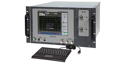
Test suite
For in-vehicle and V2V connectivity
Spirent’s TTsuite-WAVE-DSRC (Wireless Access in Vehicular Environments – Dedicated Short-Range Communications) conformance test solution includes a set of tests required for U.S. Department of Transportation (USDOT) certification. TTsuite-WAVE-DSRC consists of four different protocol conformance test suites as per the USDOT Certification Operating Council (COC) conformance test specifications. It enables full test automation, includes frameworks for individual adaptation, and it is extensible with many plug-ins to meet constantly changing development requirements. TTsuite-WAVE-DSRC is targeted at companies supplying or testing WAVE-DSRC ITS technology.
Spirent Communications, www.spirent.com
Survey & Mapping
 GNSS receiver
Multi-frequency, multi-application and multi-use
The SP90m GNSS receiver is a powerful, highly versatile, ultra-rugged and reliable GNSS positioning solution for a wide variety of real-time and post-processing applications. Integrated communications options include Bluetooth, Wi-Fi, UHF radio and cellular modem as well as two MSS L-band channels to receive Trimble RTX correction services. The SP90m can be used as a base station, campaign receiver, continuously operating reference station (CORS), real-time kinematic (RTK) or Trimble RTX rover, or be integrated on-board a machine. The receiver uses all available GNSS signals to deliver fast and reliable positions in real time, and allows the connection of two GNSS antennas for precise heading or relative positioning determination without a secondary GNSS receiver. It features an internal removable battery, internal memory and optional accessory kits for specific applications.
Spectra Precision, www.spectraprecision.com
Field-to-office software
 For total stations, robotics and GNSS rover systems
GeoPro Field provides a graphical user interface designed to collect field measurements for land surveying and construction activities. GeoPro Field is a tool to collect and import measurement data into design and drafting software, increasing productivity with CAD functionality in the field. It is compatible with various software workflows, and point files are easily exported to third-party software. Sokkia GeoPro Office is the office-processing complement to the field software — designed to clean, process, and analyze field data into its easiest-to-use form. The office software can also be expanded with an optional 3D and road design module, for further versatility to design roads with the processed field measurements.
Sokkia, www.sokkia.com
RTK base and rover
 Ready for highway and site construction
Hemisphere GNSS’ C321 GNSS Smart Antenna is designed for heavy highway and site construction. When paired with SiteMetrix Site Management software, the multi-frequency, multi-GNSS C321 antenna can be used as an all-in-one construction base and rover site controller. The C321 combines the Athena GNSS engine and Atlas L-band correction technologies. The ruggedized antenna is designed for the most challenging environments and meets IP67-standard requirements. Powered by Athena GNSS engine, the C321 provides best-in-class, centimeter-level RTK. Athena excels in virtually every environment where high-accuracy GNSS receivers can be used. Tested and proven, Athena performs with long baselines in open-sky environments, under heavy canopy, and in geographic locations experiencing significant scintillation. The C321 ships pre-configured to test-drive corrections from Hemisphere’s Atlas L-band corrections service. C321 also uses Hemisphere’s aRTK technology, powered by Atlas. This feature allows the receiver to operate with RTK accuracies when RTK corrections fail. If the C321 is Atlas-subscribed, it will continue to operate at the subscribed service level until RTK is restored.
Hemisphere GNSS, www.hemispheregnss.com
RTK GNSS tablet
 Centimeter-level positioning
Toughpad is Panasonic’s newest professional-grade notebook, specifically designed for precision agriculture, machine control and robotic guidance applications in harsh environments and conditions. Embedded in the tablet is a u-blox NEO-M8 GNSS receiver module delivering high integrity and precision in demanding applications worldwide. First tested for collecting snow in Hokkaido, Japan, the Toughpad tablet uses Panasonic’s own satellite positioning technology combining a satellite radio receiver module, wireless WAN, and a single-band real-time kinematic (RTK) GNSS receiver connected to an external antenna. The system enables high-precision positioning down to centimeter level in open-sky conditions.
Panasonic, www.panasonic.com
u-blox, www.u-blox.com
Mobile app
 Aids in understanding the oceans
Esri has released an Ecological Marine Units (EMU) app for mobile devices. The app provides a new way to measure marine environments on a 3D interactive map for more cost-effective fishery planning and informed conservation. It is a resource for scientists, educators, governments and industries seeking accessible information and imagery about the ocean’s long-term physical and nutrient properties. The EMU app puts data such as temperature, salinity and dissolved oxygen from 52 million locations throughout the world’s oceans at any user’s fingertips. This data informs how livable marine environments are for ocean-dwelling species as well as the overall health of the ecosystem. The app is free from the App Store and Google Play.
Esri, www.esri.com
Post-processing software
 Delivers CAD drawings from ground-penetrating radar data
DX Office Vision is a utility post-processing software for mapping ground-penetrating radar (GPR) data from the field into a CAD drawing. It allows even non-experienced users to obtain professional 3D CAD drawings and visualize the detected underground utilities in a simple way. The intuitive interface enables users to filter, select, identify and make annotations of the located targets. With DX Office Vision, post-processing for all ground-penetrating data requires no add-on or third-party software.
Leica Geosystems, www.leica-geosystems.com
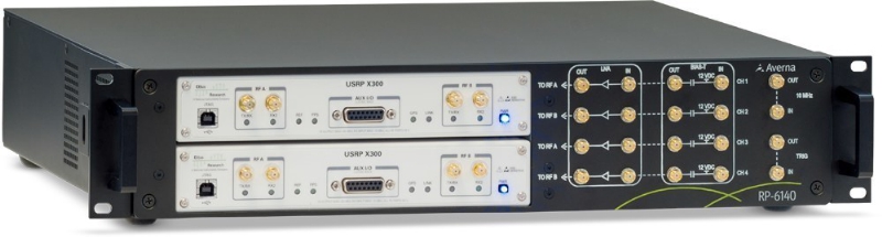
Transportation
Infotainment testing
For the connected-car market
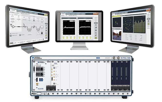
 Averna has entered a strategic partnership with M3 Systems to distribute their StellaNGC GNSS Simulator on VST NI platforms for the infotainment segment of the automotive market. M3 Systems’ GNSS simulator, based on National Instruments’ Vector Signal Transceiver (NI VST), will now be available as part of Averna’s AST-1000 platform, extending its capability to navigation and GNSS testing. Launched in July 2016, the AST-1000 is an RF solution designed for radio, navigation, video and connectivity testing. Also based on the NI VST, the software-defined AST-1000 supports infotainment RF signals, including AM/FM, DAB, RDS, HD Radio and Sirius/XM as well as GNSS navigation. The combination provides a comprehensive solution and enables applications for testing infotainment systems.
Averna, www.averna.com
 LTE automotive-grade module
Optimized for connected cars
The LE940A9 automotive-grade module is designed to support LTE Advanced Category 9 (Cat 9) networks. The series offers three multi-band, multi-mode variants — including voice-over-LTE (VoLTE) — and is optimized for automobile manufacturers to deploy next-generation connected-car technology in world markets. The LE940A9 delivers 450 Mbps download and 50 Mbps upload speeds with extremely low latency and advanced security. The xE940A9 40×40 mm LGA form factor nests with the 34x40mm Telit xE920 automotive module family, offering flexibility for the OEM or tier-one integrator. It powers the entire connected-car platform, supporting current needs while including advanced features that enable future integration of upcoming services. The module can run in-vehicle applications inside a secure processing environment from the built-in application processor, storage and memory. Automotive application programs can run entirely and securely on the module itself, protected by advanced cyber-security capabilities.
Telit, www.telit.com
Reference design
 Nine antennas including four LTE, two Wi-Fi, GNSS, SDARS and DSRC
The Axiom is a reference design for a low-profile, compact multiple-antenna solution for the next generation of connected cars. The Axiom reference design helps automobile manufacturers more quickly advance antenna configurations that work for their particular make and model. As many as 18 antennas are needed to power the next-generation connected car, including multiple cellular antennas for network connectivity; Wi-Fi for hotspot connectivity; GNSS for navigation, emergency call systems and other location-based technologies; satellite radio (SDARS); AM/FM antennas; radar antennas for object detection; Bluetooth antennas for smartphones and other devices, and dedicated short-range communications (DSRC) antennas for vehicle-to-vehicle/infrastructure applications.
Taoglas, www.taoglas.com
Ground robotics
 Ruggedized module based on military design principles
The Duro is a ruggedized version of Swift Navigation’s Piksi Multi dual-frequency RTK GNSS receiver. Built for outdoor operations, Duro combines a rugged enclosure with centimeter-accurate positioning. Leveraging design principles typically used in military hardware, the GNSS sensor is protected against weather, moisture, vibration, dust, water immersion and unexpected circumstances that can occur in outdoor long-term deployments. It is ready to connect out of the box. Primary industries for this product include robotics, precision agriculture, mapping, military, outdoor industrial and maritime.
Swift Navigation, www.swiftnav.com
Carnegie Robotics, www.carnegierobotics.com
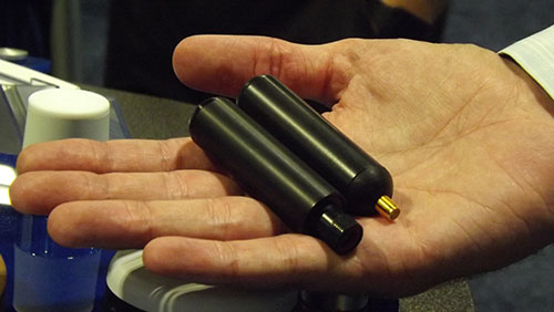
UAV
GPS-INS for drones
 Now in beta mode for summer release
The μINS is a precision miniature GPS-aided inertial navigation system (GPS-INS) designed to provide high-quality direction, position and velocity data for drones and robotic applications. It uses a u-blox L1 GPS receiver. Advanced algorithms fuse output from micro-electro-mechanical system (MEMS) inertial sensors, magnetometers, barometric pressure, and a high-sensitivity GPS (GNSS) receiver to deliver fast, accurate and reliable attitude, velocity and position even in the most dynamic environments. Sensor calibration, standard on all units, minimizes undesirable effects of manufactured variation and maximizes sensor performance. Features include GPS UTC time synchronization; an inertial measurement unit with comprehensive calibration for bias, scale factor and cross-axis alignment; –40°C to 85°C temperature compensation; a measurement of 15.6 x 12.5 x 6.3 millimeters; and a weight of 2 grams.
Inertial Sense, www.inertialsense.com
UAV helicopter
 Designed for high-altitude flight
The Scout B-330 UAV helicopter is built with a payload capacity of up to 50 kg. (110 pounds), flight endurance of at least three hours, and the capability of flying at high altitudes (up to 3,000 meters above sea level) in a typical mission scenario. This includes a full autonomous take-off sequence, a mission flight at variable speed, and a landing sequence. The Scout B-330 is specifically designed for lidar-based powerline mapping missions. It pairs with Riegl airborne and unmanned lidar sensors such as the Riegl VP-1 Helicopter Pod, the Riegl VUX-1UAV lightweight UAV laser scanner, and the Riegl VUX-1LR lightweight, long-range airborne laser scanner.
Aeroscout, www.aeroscout.ch
Situational awareness
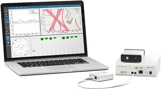
 Certifiable application for unmanned traffic management
The IRIS UAS Airspace Situational Awareness application meets the requirements of the DO-278A Assurance standard for Air Traffic Management systems, providing a certifiable option to monitor drones and airspace. By anticipating the regulatory requirements for airspace visualization with Unmanned Traffic Management or UTM, the IRIS display will be a regulatory-approved component increasing the safety of commercial drone flight operations — especially when operating beyond visual line of sight (BVLOS). The application had its genesis in supporting military UAV flight operations and was developed to help operators safely pilot UAVs in BVLOS operations. It was also used by regional airspace UTM managers to monitor the operations of multiple drones simultaneously. The DO-278A standard is used by certification authorities such as FAA, EASA and Transport Canada.
Kongsberg Geospatial, www.kongsberggeospatial.com
 Precision pointing gimbal
Better than 0.3-degree accuracy, plug-and-play
The miniature Epsilon series of gyro-stabilized gimbals now have a precision geo-pointing feature. The feature, Precision Geo-Lock, combines a GPS-aided inertial navigation system (GPS/INS) with dedicated software algorithms and payload operator software. Precision Geo-Lock provides the user with highly accurate target geo-location, range-to-target, as well as Geo-Lock functionality and moving map user interface. It incorporates VectorNav’s VN-200, which offers a high-level of performance in a form factor small enough to be integrated directly into the optical bench of the gimbal. Precision Geo-Lock provides better than 0.3-degree accuracy and is plug-and-play, so the customer can install the Epsilon gimbal and get accurate results on any platform and in a high-vibration environment.
Octopus ISR Systems, www.octopus.uavfactory.com
VectorNav Technologies, www.vectornav.com