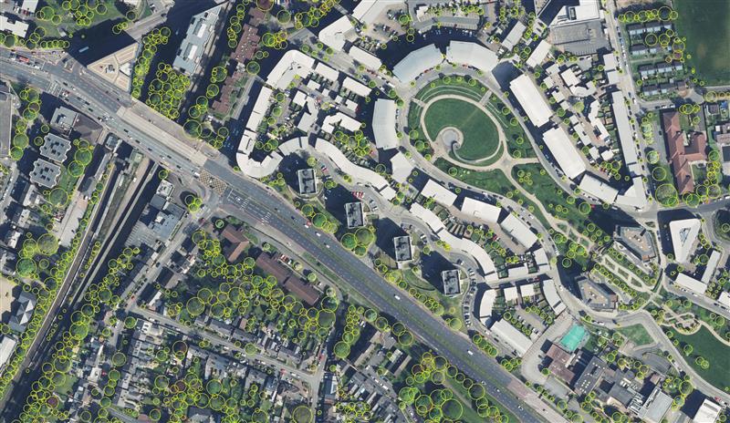
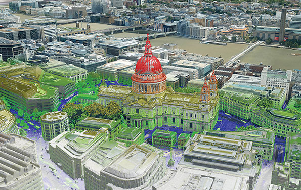
Birmingham City Council has launched a mapping portal to address the issue of tree equity across the city.
With UK national tree map data, created by aerial mapping company Bluesky International, the interactive tool allows users to identify which parts of the city have lower than average tree canopy cover and investigate possible relationships between canopy cover and other socio-economic and environmental factors. The online platform also enables users to model different scenarios and targets to identify planting opportunities and locations to increase the number of trees.
The national tree map was created using innovative algorithms and image processing techniques, from the most up-to-date aerial photography and terrain data for the whole of Great Britain and Ireland. It provides a detailed reference as to the location, canopy cover and height of trees 3 m and taller that can be applied alongside other data to establish ownership, proximity to other features or assets, and relationships between demographic, economic or social data.
National tree map data is widely used by a number of different market sectors such as local authorities, energy companies, property developers and academic and research organizations, investigating the role of trees and green spaces and their impact on health, environment and infrastructure.
Bluesky International and SkyFi have collaborated to provide access to Earth observation assets and multi-perspective imagery to users globally. Bluesky is providing its high-resolution aerial imagery, taken by aircraft-mounted cameras, to SkyFi to make available for businesses, forestry, water and land managers across the United Kingdom.
SkyFi aims to make Earth observation data more accessible to users through its growing network of satellites and aerial platforms. The company has created a data marketplace where users can purchase existing images or task a satellite to purchase a new image.
Bluesky provides a wide range of geospatial data products and services to users across the United Kingdom. GIS and CAD-ready imagery from Bluesky captures ground terrain, cityscape rooftops, fauna and more. The company’s catalogue of aerial imagery is available in England, Scotland, Wales and the Republic of Ireland.
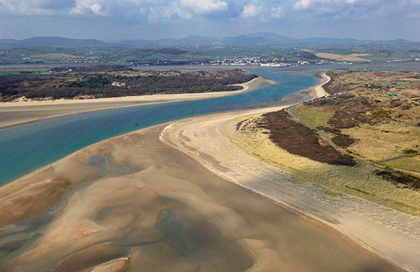
Dundrum Bay on the coast of Northern Ireland is captured by a mapping airplane in a project to document climate change effects. (Photo: DAERA/Bluesky)
Bluesky International will use aircraft-mounted lidar sensors and laser scanners to create a highly detailed 3D map of the whole of the Northern Ireland coastline.
Working on behalf of the Department of Agriculture, Environment and Rural Affairs (DAERA), the lidar survey will be used to create the first complete baseline. The baseline will underpin recording of coastal change and help identify the rate at which the coastline is changing as a result of climate change.
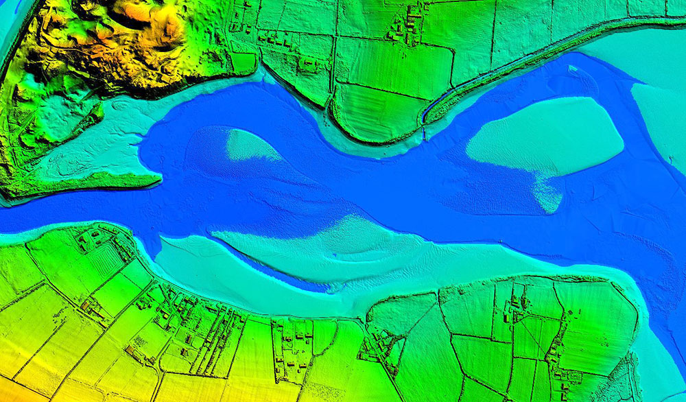
In addition to the lidar data Bluesky will simultaneously capture high detailed aerial photography which will be processed to produce to a fully orthorectified, 10-centimeter-resolution database.
The Bluesky data will form part of the wider Northern Ireland 3-dimensional coastal survey. The survey will extending into the marine environment with a satellite-derived bathymetric survey and a pilot bathymetric lidar survey. Together, the surveys will inform the development of future coastal management policies.
“The Northern Ireland coast is a hugely valuable resource which is currently facing increasing pressure from climate change,” said Joanne Hanna, senior scientific officer within the Marine and Fisheries Division of DAERA. “Sea-level rise, in combination with an increase in extreme storm events, is resulting in greater energy impacting our coastlines, altering coastal processes and accelerating change.
“Despite the importance and the value of this coastline, the nature and scale of the issues arising from coastal change and sea-level rise are currently not known and there is limited and insufficient baseline data available,” Hanna said. “The coastal lidar survey carried out by Bluesky will provide scientifically robust baseline data which will enable decision makers and coastal managers to make informed decisions and devise solutions and appropriate management to the problems currently facing our coastline.”
Bluesky will undertake the specialist survey using a fixed wing manned aircraft and will fly the 763 kilometres of Northern Ireland coastline capturing height measurements of both the underlying terrain and any surface features at a resolution of better than 16 points per metre. This data will be used to create highly accurate 3D digital terrain and surface models (DTM, DSM) with a spacing of up 25 centimetres.
The Bluesky datasets will be supplied ready for use in a range of geographical information system (GIS), desktop mapping and other specialist software packages and will be compatible with other DAERA datasets including Ordnance Survey mapping.
Bluesky International launched its international MetroVisa city mapping service for Europe at Intergeo 2019, which took place Sept. 17-19 in Stuttgart, Germany.
The Bluesky MetroVista range includes high-resolution imagery combined with high-accuracy, wide-scale 3D models. (Image: Bluesky)
Aerial mapping company Bluesky is releasing its entire catalog of geographically referenced oblique aerial images of cities in the United Kingdom (UK) via a new subscription-based streaming service.
Working with Geoxphere, a specialist in cloud-based GIS, Bluesky will offer MetroVista imagery via an easy-to-use web viewer that also includes measurement tools for detailed analysis of building features, façade details and street furniture locations.
“Oblique imagery offers an unparalleled view of the built environment revealing real world features simply not present in any other type of aerial image or map,” commented Rachel Tidmarsh, managing director of Leicestershire-based Bluesky International. “The MetroVista imagery can be used to inform decision making with time stamped intelligence, and even evidence, as well as improving engagement with colleagues through better communication of ideas. All of this without even leaving your desk!
“However this wealth of information, as you would expect, can present some issues when it comes to storing and consuming data. The MetroVista Oblique Viewer overcomes these issues meaning the value of the data can be realised without the burden of storing, processing or updating.”
With a data-as-a-service (DaaS) solution powered by Geoxphere’s XMAP geospatial cloud technology, the MetroVista Oblique Viewer is a fully managed subscription service meaning there is no need to download or store large volumes of data locally. The MetroVista Oblique Viewer does not require any specialist software, plugins or downloads and, as the data is also managed, newly captured images are automatically added to an account as they become available.
The MetroVista Oblique Viewer has split screen options and rotating views allowing the user to toggle through images to get a 360 degree view of a building. The Bluesky Geoxphere Viewer also includes height and area measurement tools for recording a building height or distance from a feature and its façade area.
Captured using the world’s first large format imagery and lidar hybrid airborne sensor, Bluesky MetroVista imagery collection includes simultaneously captured oblique and vertical aerial photography. The MetroVista datasets also include geographically accurate, photo-textured, mesh models ready for use in 3D GIS, CAD and other modelling software as well as visualisation, gaming and Virtual Reality workflows.
Bluesky has already captured MetroVista data for cities such as London, Birmingham, Manchester, Bristol, Nottingham, Oxford, Cambridge, Brighton, Norwich, Leicester, Derby and Newcastle as well as Bournemouth, Brighton, Cardiff, Doncaster, Eastbourne and Southend.
The Bluesky MetroVista range includes high-resolution imagery combined with high-accuracy, wide-scale 3D models. (Image: Bluesky)
Bluesky International has launched its international MetroVista city mapping service for Europe at Intergeo 2019, which took place Sept. 17-19 in Stuttgart, Germany.
The mapping service incorporates the Leica CityMapper hybrid airborne sensor, which can simultaneously capture vertical and oblique aerial photography, as well as lidar.
According to the company, the Bluesky MetroVista range includes high-resolution imagery combined with high-accuracy, wide-scale 3D models. Bluesky’s CityMapper also has already been used to capture MetroVista data for cities across the United Kingdom, including London, Manchester, Newcastle and Bristol.
Bluesky’s CityMapper, used to produce the MetroVista data, includes a traditional vertical camera, as well as survey-grade oblique cameras. The sensor, designed for 3D city modeling and urban mapping, incorporates lidar technology to accurately collect elevation and infrared data.
“Here at Intergeo, we’re showing our MetroVista data sets, which are the city meshes,” Ralph Coleman, sales director at Bluesky, told GPS World. The city meshes are extremely dense, they’re very feature-rich, and they’re vey accurate. They provide a vast range of detail for a massive range of applications.”
Bluesky is a United Kingdom-based aerial survey and geographic data company that produces and maintains digital aerial photography and height data. The company has offices in the United Kingdom, United States and the Republic of Ireland, as well as a production center in India.
British aerial mapping innovator Bluesky International is expanding its business into North America following the acquisition of Col-East Inc., a Massachusetts-based aerial survey company. Col-East has been mapping the Northeast United States for 65 years and will continue as Col-East International Ltd., forming the U.S. arm of Bluesky.
Founded in 1952, Col-East has a long-established reputation for high-quality topographic mapping with particular expertise in specialized aerial surveys, such as high-precision aeronautical mapping requiring skilled analysis. Bluesky has seen an increase in the demand for specialized large-scale mapping, 3D modeling and feature extraction in recent years in the European market, and the company intends to apply these skills to the expanding U.S. market.
Bluesky has improved on aerial mapping techniques in the UK in recent years, backed by the latest digital cameras and 3D laser mapping technology. The Leicestershire-based company will not only be equipping Col-East aircraft with the latest digital aerial surveying equipment, including cameras and sensors for laser (lidar), thermal and infrared capture, but will also be building on the existing technical and experienced Col-East skill base by introducing new workflows and image-processing techniques honed in the competitive U.K. and European markets.
“Britain has a long tradition as a pioneer in mapping techniques, and the Bluesky team was behind the creation of what was the world’s first nationwide high-resolution aerial photo map, created back in 1998,” said Rachel Tidmarsh, managing director of Bluesky International Ltd. “Since then, we have developed new systems and techniques that are underpinning advances in environmental and 3D mapping, and we will be introducing these advancements to the U.S. market with the acquisition of Col-East.”
As well as topographical mapping and aeronautical work, Col-East offers a range of aerial imaging services such as the production of terrain models, orthophotos and volumetrics, providing cost-effective mapping solutions from estates to development sites and complex transportation corridors.
Col-East owns a huge archive of aerial photography that has been captured over many years and dates, back to 1946. Col-East will gain immediate access to Bluesky’s proprietary technology used in the development of some ground-breaking derived products, including 3D building modeling, tree mapping, air quality mapping and state-wide solar power potential mapping. Products will also be available to purchase through the new Col-East online Mapshop, which will be launched soon.
“It’s a very exciting time for Col-East,” said Mark Thaisz owner and general manager at Col-East. “Bluesky is bringing significant investment, new technology and added resources that will allow the business to expand freely. Already we’ve equipped our aircraft with a new Vexcel UltraCam Eagle survey camera which offers high accuracy and unsurpassed clarity to bring a whole new edge to the aerial survey market in New England.”