New-generation aircraft ELT meets new European Union Aviation Safety Agency (EASA) and U.S. Federal Aviation Administration (FAA) requirements
Photo: Orolia
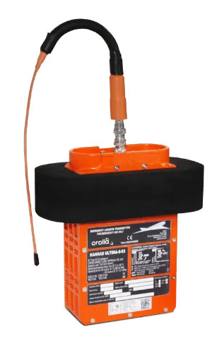
Orolia has received certifications for yet another survival emergency locator transmitter (ELT), the Ultima-S.
The news follows Orolia’s announcement that it had received certification for the Ultima-DT model, as well as a personal locator now shipping to the U.S. Army.
The Ultima-S is a new generation ELT installed in either the cabins or liferafts of aircraft. It relays accurate aircraft location information to search-and-rescue teams.
Once activated, a 406-MHz distress signal is transmitted and includes the ELT’s location thanks to the Ultima-S internal GNSS receiver. This built-in GNSS capability increases both probability and speed of detection of the distress signal.
“With these key certifications for the Ultima-S, Orolia brings a long-awaited solution to the industry,” said Jérôme Ramé, Orolia’s Aviation & Military Product Line Director. “We have developed strong partnerships with several of the leading aircraft manufacturers that will enable operators worldwide to benefit from the Ultima-S for both their linefit and retrofit needs, allowing fleet standardization.”
The Ultima-S provides free, global coverage service through the dedicated Cospas-Sarsat infrastructure while meeting the highest aviation safety standards. Orolia offers non-rechargeable lithium batteries compliant with the latest FAA and EASA special conditions standards, also known under TSO-C142b/DO227A. The Ultima-S also meets the most recent ELT performance and environmental standards through TSO-C126c.
“What makes the Ultima-S unique is a new feature called the Return Link Service (RLS),” said Ramé. “Through this capability, the user is automatically notified when the distress signal is detected and located by the Cospas-Sarsat ground infrastructure. The Ultima-S links directly to the European Galileo GNSS satellite constellation, providing the most reliable and timely information for reaching aircraft crew members in distress.”
In addition to being available on a linefit basis on major aircraft programs, Orolia has launched an exchange program to make retrofit activities easier for airlines, especially those upgrading to safer battery technology.
Orolia’s PRSS1b PRD provides second-generation Cospas-Sarsat signaling that delivers faster and greater location accuracy than previously fielded tactical location devices.
Photo: Orolia
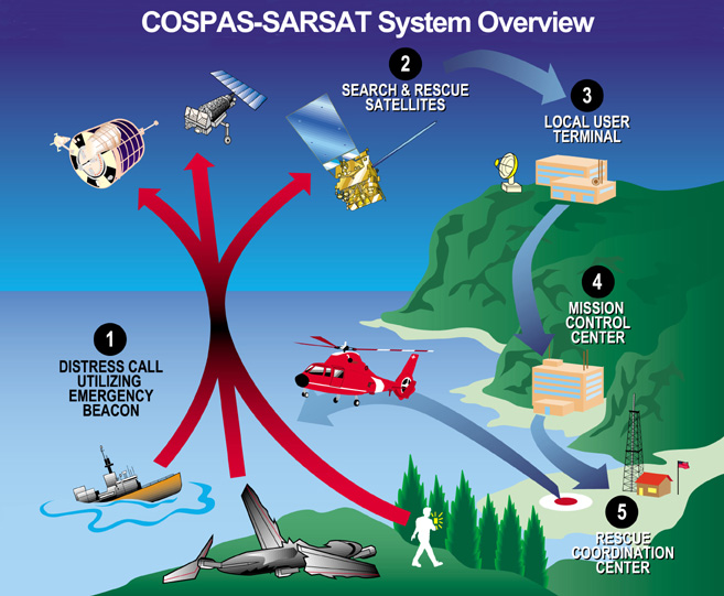
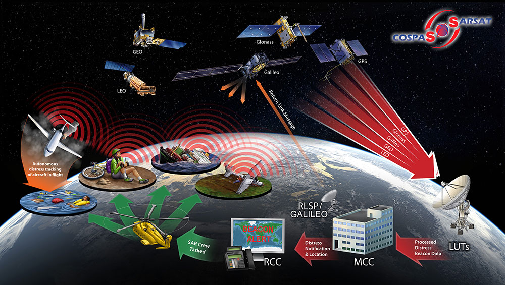
Cospas-Sarsat is an international, humanitarian search-and-rescue system that uses space-based technology to detect and locate model 406 emergency beacons carried by ships, aircraft or individuals venturing into remote areas, often inaccessible by mobile phone. The system consists of a network of satellites, ground stations, mission control centers (MCCs) and rescue coordination centers (RCCs) that work together when a 406 beacon is activated.
Through collaboration with the Army, Orolia produced a robust, user-friendly and highly reliable device to locate personnel who become isolated, missing, detained or captured.
Orolia conducted a demonstration in October simultaneously on multiple continents, showing its technology working with the worldwide coverage provided by the Cospas-Sarsat infrastructure. The demonstration yielded beneficial data to support the qualification of Orolia’s Personnel Recovery Device and helped inform government stakeholders on the readiness of the second-generation ground and satellite infrastructure.
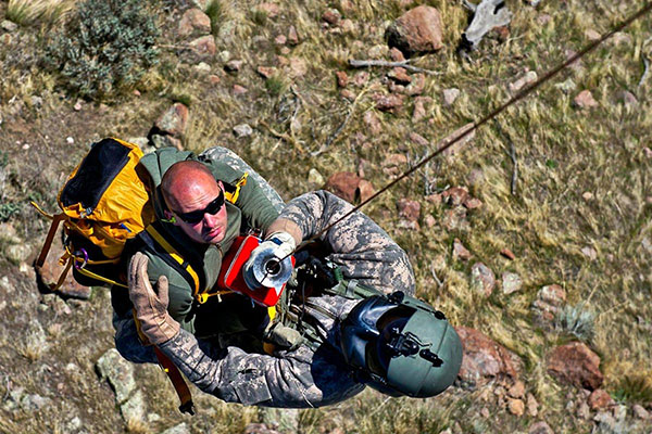
A U.S. Army HH-60 Black Hawk helicopter lowers a volunteer from Central Washington Mountain Rescue via the hoist system during a training exercise.(Photo: U.S. Army)
Also in October, Orolia received Cospas-Sarsat certification for its Ultima-DT ELT emergency transmitter, designed for use on aircraft. All 406-MHz emergency beacons are digitally coded and transmit distress signals immediately upon activation on a proprietary radio wavelength.
The three main types of 406 distress beacons and the kinds of situations for which each is designed: wilderness, marine and aviation environments. (Image: Cospas-Sarsat)
The approval paves the way for Orolia’s ELT-DT to play essential roles in meeting the aviation industry’s advanced safety mandates worldwide
The Ultima-DT emergency locator. (Photo: Orolia)
Orolia is the first company to receive certification from Cospas-Sarsat and the European Union Safety Agency for its new-generation distress tracking emergency locator transmitter, the Ultima-DT.
The approval verifies Orolia’s continuous advancements in global beacon technology, including securing a single source, multi-year program contract to supply ELT-DTs for all Airbus aircraft programs.
Cospas-Sarsat is an international, humanitarian search-and-rescue system that uses space-based technology to detect and locate model 406 emergency beacons carried by ships, aircraft or individuals venturing into remote areas, often inaccessible by GNSS signals. The system consists of a network of satellites, ground stations, mission control centers (MCCs), and rescue coordination centers (RCCs) that work together when a 406 beacon is activated.
“Being the first company to certify a distress tracking ELT shows again Orolia’s unique ability to provide the industry with the most innovative safety solutions,” said Jérôme Ramé, Orolia’s aviation and military product line director. “With Ultima-DT, we address the EASA-mandated requirement for the location of aircraft in distress, but also the market need for an ELT meeting the most recent safety standards.”
Orolia developed the Ultima-DT in response to aviation safety mandates to improve global aircraft tracking. As per the ICAO Global Aeronautical Distress and Safety Systems (GADSS) recommendation and European Union mandate, all new aircraft delivered from January 2024 shall be able to autonomously report their location anywhere in the world and determine the end-of-flight location to help rescue teams rapidly locate the aircraft and recover flight recorders.
Unlike traditional automatic fixed ELTs and stand-alone units, the Ultima-DT is tightly connected to the avionics system. It activates upon detecting a potential distress condition and starts transmitting automatically while the aircraft is still in flight. This next-generation ELT autonomously acquires the aircraft’s location and sends a 406-MHz message in real-time, including the accurate location, to the Cospas-Sarsat distress alert organization.
The Ultima-DT is also the first ELT to fully comply with the latest EASA/FAA safety requirements for non-rechargeable lithium battery-powered equipment through (E)TSO-C142b. As part of its efforts to support airlines in their regulatory compliance projects, Orolia is also offering its portable Ultima-S ELT, which aims to meet these special conditions.
Galileo Second Generation Batch#1A satellites. (Image: ESA).
Successful European Cooperation
Galileo is Europe’s civil global satellite navigation constellation and a major success, being the world’s most precise satnav system and offering meter-scale accuracy to more than two billion users around the globe.
The signature of the Financial Framework Partnership Agreement (FFPA) on June 22, 2021, further strengthened effective cooperation between the European Commission (EC), the European Union Agency for the Space Program (EUSPA), and the European Space Agency (ESA) — key to successfully achieving a crucial EU Space Program component like Galileo in the current EU Multi Financial Framework (2021–2028).
The EC is the program manager, with EUSPA acting as the exploitation manager and ESA as the system development prime.
Stable Service Performance
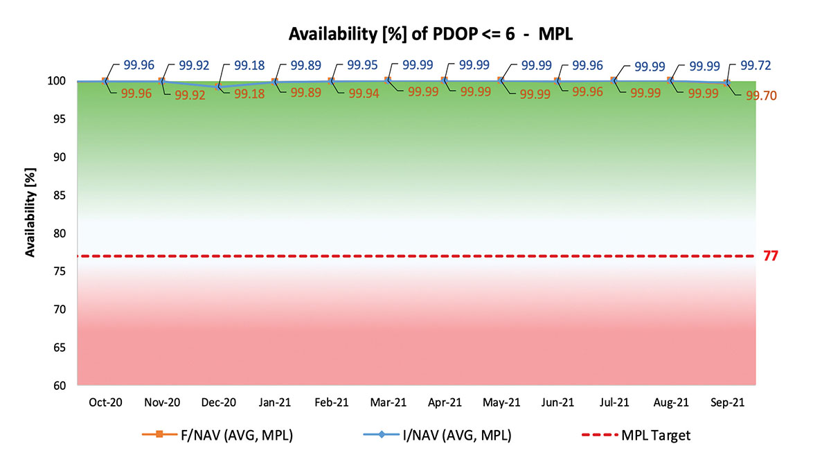
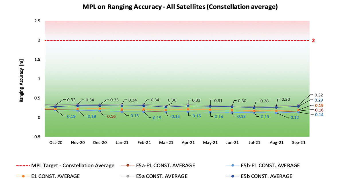
Galileo continues to deliver excellent service performance every month in a safe, secure and seamless manner. Delivery of Galileo services is managed by EUSPA, as the Galileo service provider, with industrial partner SpaceOpal, the Galileo service operator prime contractor. The performance of Galileo services is independently monitored by the Galileo Reference Center (GRC) and regularly published on the GNSS Service Center (GSC) web portal at www.gsc-europa.eu — both agencies were developed by GMV. The security of the Galileo System is monitored by the Galileo Security Monitoring Centers (GSMC), operated by EUSPA.
With 22 satellites in service, the open service is already delivering more than 99% availability of PDOP <= 6 worldwide. This, together with the excellent ranging accuracy, suggests that most Galileo dual-frequency users are typically experiencing positioning accuracy in the order of only 2 to 3 meters.
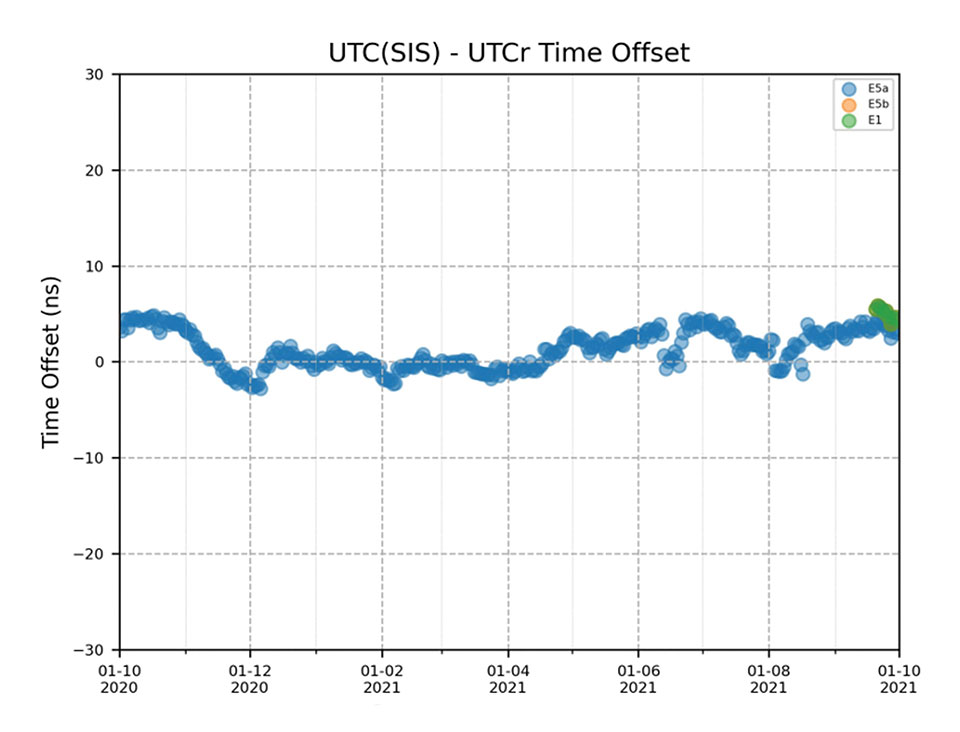
Timing users also continue to receive accurate (in the order of 5 ns) access to Galileo System Time, which they can trace to Universal Coordinated Time (UTC) through the corresponding offset parameters transmitted by the satellites.
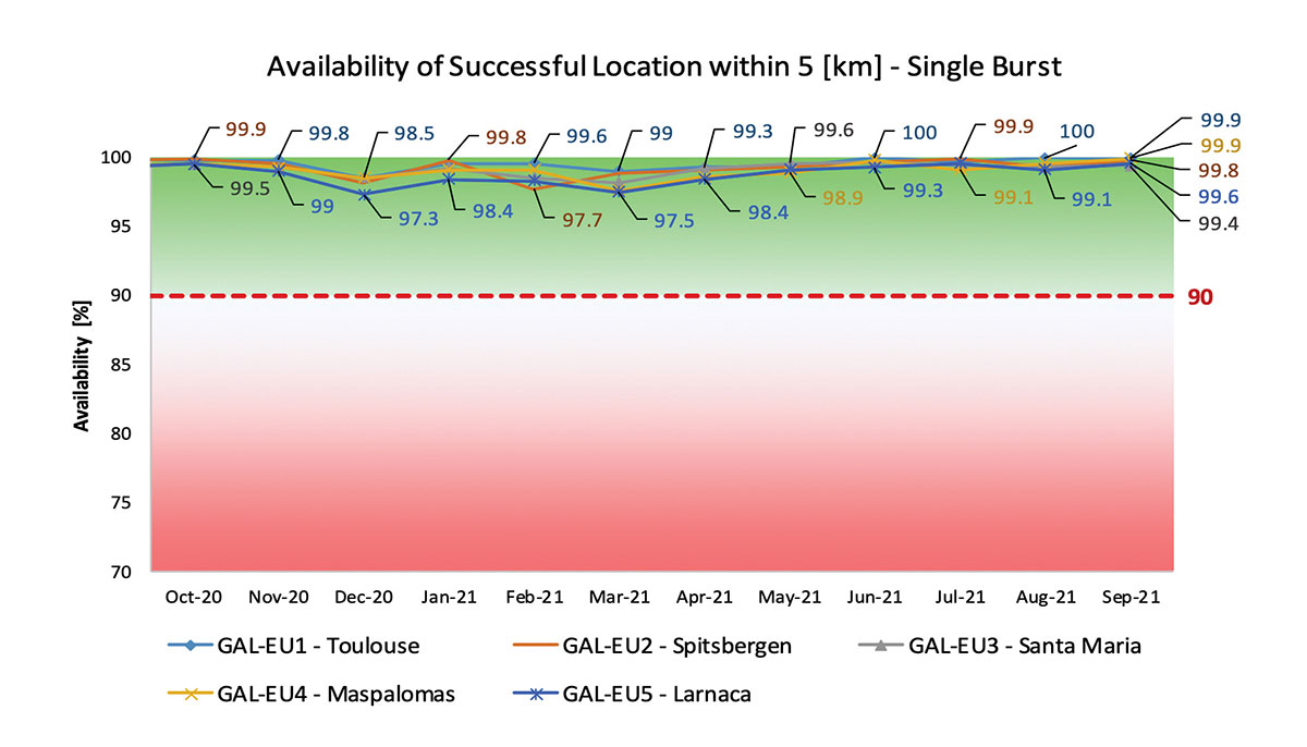
The SAR/Galileo service, contributing to COSPAS/SARSAT, continues to deliver both the Forward Link Service (FLS) and the Return Link Service (RLS) with more than 99% availability, allowing users in distress not only to issue an alert and be located within a few minutes, but also be notified that the alert was successfully processed and rescue is on the way. The SAR/Galileo control center is located in Toulouse (France) and operated by CNES under the authority of EUSPA. The excellent performance of the service has been demonstrated both through several rescue exercises and real-life emergencies.
Performance of Galileo positioning services. (Credit: EUSPA)
Performance of Galileo positioning services. (Credit: EUSPA)
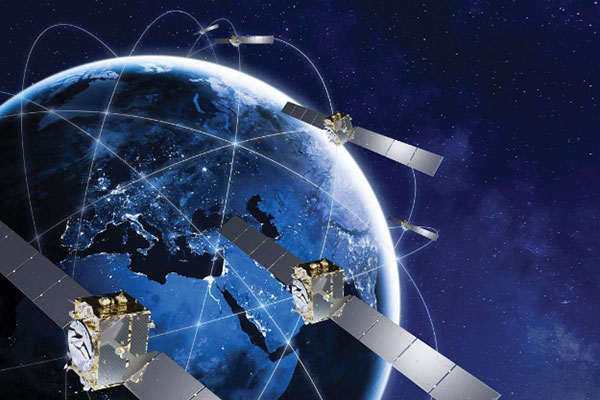
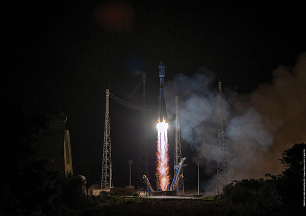
Galileo Launch 11
Soyuz launcher VS-26 lifted off from French Guiana with the first pair of Galileo Batch 3 satellites on Dec. 5, 2021, at 01:19 CET. This marks the 11th Galileo launch of operational satellites in 10 years: a decade of hard work by Europe’s Galileo partners and European industry. With these satellites, the robustness of the constellation has increased, guaranteeing a higher level of service.
Thanks to an upgrade of the Ground Control Segment, the Launch and Early Orbit Phase has been for the first time conducted directly from the Galileo Control Center, rather than requiring an external mission control site. This version of the ground segment increases overall reliability and cybersecurity and opens the way to significant expansion of the Galileo constellation, allowing command and control of up to 38 satellites. The development has been performed by an industrial consortium led by GMV, harnessing state-of-the-art technology using the latest solutions on the market.
Galileo launch 11 from Europe’s spaceport in French Guyana. (Photo: ESA)
On Route to Full Operational Capability
This year will pave the way toward Full Operational Capability of Galileo services.
Industrial prime contractor OHB Systems has nearly completed production of the additional 10 recurrent satellites belonging to Galileo Batch 3. Six of them are undergoing final acceptance testing at the ESA satellite test center, and the other four are under integration at the satellite prime facilities.
Preparation for Launch 12 has already started, with the satellites’ acceptance for a launch date planned in the first months of 2022, followed by Launch 13 in autumn. This is leading toward completion of the Galileo constellation, providing an increased availability of the Galileo signal in space for both GNSS and search-and-rescue users.
Performance of Galileo timing and search-and-rescue services. (Credit: EUSPA)
Performance of Galileo timing and search-and-rescue services. (Credit: EUSPA)
From 2023 onward, the remaining Batch 3 satellites will be launched with the new Ariane 62 launch vehicle, a variant of Ariane 6 with two strap-on solid boosters. The launcher is undergoing the final stages of development, led by prime contractor ArianeGroup.
The Galileo Ground Mission Segment will undergo a complete technological refresh, including hardware virtualization and porting of several million lines of code, performed by an industrial consortium led by Thales France. A series of improvements will be introduced to increase system resilience, including an extended mode of operation to improve service continuity and robustness.
Cybersecurity monitoring of all the ground assets will be introduced as an overlay to the current ground infrastructure. The upgrade will undergo a rigorous level of qualification testing followed by worldwide deployment in a seamless way in both Galileo control centers, in both Galileo security monitoring centers, and at all remote locations without affecting continuity of service.
The service facilities that contribute to the delivery of Galileo services (the European GNSS Service Center, the Galileo Reference Center, and the SAR data service providers) will also evolve to support not only the transition from Initial Services to Full Operational Capability, but also the early roll-out of service evolutions. In this regard, extensive work is ongoing to deliver an exciting set of improvements, some of which are already in development or testing, to reach the users in the year to come:
Improvements of the I/NAV signal to increase robustness and time-to-first-fix, while assuring full backward compatibility with legacy receivers.
OS Navigation Message Authentication (OS-NMA) to support applications that require trust in the authenticity of the data transmitted by the Galileo satellites (a public observation campaign was launched in November 2021 to engage stakeholders and collect their feedback before moving to the initial service provision).
An initial phase of the High Accuracy Service, delivering corrections in the Galileo E6 signal and over terrestrial network to allow users to perform precise point positioning over Europe; test signals were already transmitted with promising results.
A Search and Rescue Beacon Command Service complementing the SAR Return Link, providing improved capabilities to timely locate beacons under authorized emergency situations (such as the disappearance of Flight MH370 in the Indian Ocean in 2014).
A first implementation of an Emergency Warning Service over Europe, allowing the authorized national emergency-management authorities of the EU Member States to relay alert messages through Galileo signals, which can reach target areas even in case of disrupted terrestrial communications (such as due to floods or earthquakes).
Galileo worldwide ground segment. (Credit: ESA)
Second Generation in the Making
The FFPA will bring Galileo to the next level with the development of the second generation, a further step forward with the use of many innovative technologies to guarantee the system’s unprecedented precision, robustness and flexibility.
In parallel to the completion of the first generation of Galileo, Europe has conducted in recent years preparation activities for the Second Generation (G2). Elaborating on market, user and exploitation needs collected by EUSPA, ESA identified a number of system evolution scenarios, which were discussed among relevant EU stakeholders to select the second-generation mission and services baseline to build the system infrastructure.
The evolution of Galileo capabilities will not only provide better services through advanced technical solutions identified by ESA, but will also ensure continuity of service and backward compatibility for
first-generation legacy users.
Two parallel contracts to develop and manufacture each of the six Galileo Second Generation Batch#1 satellites were kicked off in the first half of 2021 with Thales Alenia Space (Italy) and Airbus Defence & Space (Germany). The new G2 satellites will be constructed on a short time scale, with their first launch via Ariane-62 expected in less than four years, allowing them to commence operations in space as soon as possible. Both contracts have already undergone preliminary design reviews.
Development of the G2 satellites is supported by the Galileo Payload Test Bed, which provides an early proof-of-concept of the advanced G2 payload architecture. These satellites will provide, among others, the following key innovations:
Reconfigurable fully digital navigation payload.
Point-to-point connection between satellites by Inter-Satellite-Link for command and control and ranging functionalities.
Electric propulsion for orbit-raising capabilities.
Advanced jamming and spoofing protection mechanisms to safeguard Galileo signals.
System and Ground Segment definition studies, together with the associated technology pre-developments, have been performed, leading to the definition of the preliminary design and technical requirement baseline for the G2 system, a project involving most of Europe’s space industrial partners.
The G2 In-Orbit Validation Ground Segment and System Test Bed have been defined and relevant procurement procedures are ongoing, with these objectives:
G2 Batch#1 satellites launch and early orbit phase, in-orbit testing and enhanced legacy services provision.
G2 new capabilities in-orbit validation, including prototyping and validation of all the novel technologies that can exploit the full capabilities of the G2 Batch#1 satellites.
Galileo Second Generation Batch#1B satellites. (Image: ESA).
Definition activities for the G2 Initial Orbit Capability (IOC) are progressing well and are expected to converge in the first half of 2022, in order to establish the future roadmap for new G2 services provision in the years to come.
2022 will be a key year for the evolution of Galileo Second Generation activities, through the consolidation of the first batch of G2 satellite design and development activities and the start of development of associated G2G IOV Ground Segment and System Test Beds.
A bright future awaits Galileo, both through the completion of its Final Operational Capability and the start of evolution towards Galileo Second Generation.
Guerric Pont is Galileo Exploitation Program manager for the European Union Agency for the Space Program (EUSPA).
Marco Falcone is Galileo First Generation Project manager for the European Space Agency (ESA).
Miguel Manteiga Bautista is Galileo Second Generation Project manager for the European Space Agency (ESA).
The AMRO 2021 exercise tested the rescue of 200 cruise-ship passengers using Galileo SAR. (Photo: EUSPA)
News from the European Union Agency for the Space Programme (EUSPA)
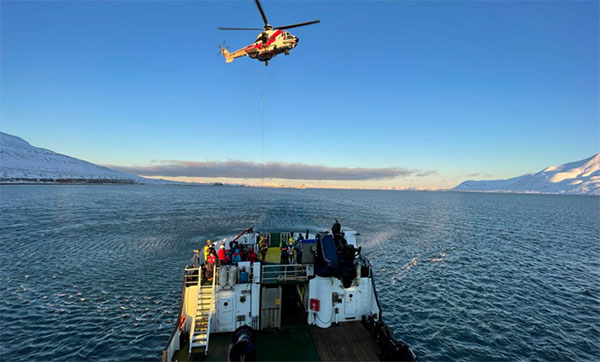
In freezing arctic waters 60 nautical miles off of Svalbard, a search-and-rescue enactment proved the capabilities of Galileo as a life-saving system.
The Arctic Mass Rescue Operation (AMRO 2021) took place on Oct. 8, organized by the Norwegian authorities. The scenario surrounded a cruise ship that caught on fire with around 200 passengers onboard, located northwest of Spitsbergen far from roads, cabins, rescue crews and other infrastructure.
The vessel’s crew activated a Galileo-enabled EPIRB compatible with Galileo’s Return Link Service. Once activated, it took only 2:20 minutes for the Galileo System to track down the ship with an accuracy below one kilometer and deliver an SOS acknowledgement to the active EPIRB.
Once the Mission Control Centers received the distress signal and established the location, two Super Puma helicopters from the Governor of Svalbard, a Sea King from the 330 squadron of the Royal Norwegian Air Force, and a Norwegian coast guard support vessel were scrambled to support the massive evacuation of the passengers.
‘’The AMRO 2021 exercise was an excellent opportunity for the European Union Agency for the Space Programme to showcase the power of Galileo SAR and the robust performance of Galileo at high latitudes in comparison to other GNSS constellations,’’ said Guerric Pont, Head of Galileo Department at EUSPA.
The Galileo RLS allows people in distress to receive an automatic acknowledgment that their signal has been picked up by the first responders. Galileo’s contribution to the Medium Earth Orbit Satellites Search and Rescue System (MEOSAR) — managed by the international COSPAS-SARSAT program — translates into 2,000 lives saved per year.
In support of Galileo’s SAR operations, the Copernicus Marine Service provides authorities and rescue centers input such as wave height, sea current direction as well as and water temperature among others.
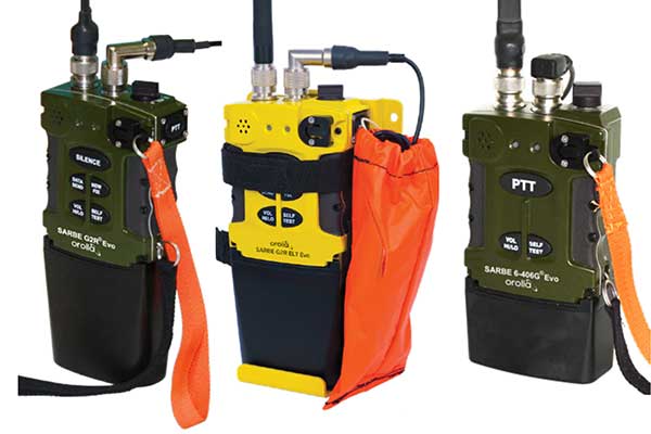
The new line of Sarbe search and rescue beacons. (Photo: Orolia)
Orolia is introducing the Sarbe Evo line at the Singapore Air Show, taking place Feb. 11-16 at the Changi Exhibition Centre. The line is being exhibited at Orolia’s Booth G10.
The search-and-rescue (SAR) beacon range has been improved to deliver upgraded operational capabilities, to meet the latest Cospas-Sarsat testability and maintenance requirements.
Part of Orolia since 2011, the Sarbe brand is a worldwide market leader for military (tri-forces) Personal Locator Beacons and Emergency Locator Transmitters. Sarbe beacons have been at the forefront of innovation in life saving Locator Beacons and critical communications for over fifty years.
Sarbe equipment is often integrated into air crew clothing such as Air Crew Life Preservers, ejection seats and survival packs, and can be optionally equipped with remote antennas and automatic activation.
The Sarbe Evo line offers new operational improvements in order to meet revised Cospas-Sarsat requirements in operating lifetime, location accuracy, voice signals management, integrated protocols, testability and maintenance.
Orolia’s development of the Sarbe Evo line has focused on the following key elements to improve customer safety:
Upgraded battery management with use-monitoring
Exceeds Cospas-Sarsat endurance requirements
Built-in-test further enhanced
More robust and frequent GPS/GNSS position acquisition with GPS, Galileo and GLONASS satellite constellations
Audio system improvement for greater clarity under all operating conditions
Introduction of the National Location Protocol
Rugged and reliability improvement (qualified to MIL-STD-810G standards) to support complex rescue missions in harsh environments
For both commercial and military needs in SAR operations, Orolia’s main goal remains the provision of highly accurate location data, and real-time voice and data communication to SAR operators through robust line of sight transmission.
As well as providing global navigation services, Europe’s Galileo satellite constellation is contributing to saving more than 2,000 lives annually by relaying SOS messages to first responders. And from now on the satellites will reply to these messages, assuring people in danger that help is on the way.
This ESA-design return link system, unique to Galileo, was declared operational this week, during the 12th European Space Conference in Belgium. The delivery time for the return link acknowledgement messages from initial emergency beacon activation is expected to be a couple of minutes in the majority of cases, up to 30 minutes maximum, depending primarily on the time it takes to detect and locate the alert.
Cospas-Sarsat rescue beacon activated. Its signals are picked up by satellites in orbit, including Galileo. (Photo: GSA)
“Anyone in trouble will now receive solid confirmation, through an indication on their activated beacon, informing them that search and rescue services have been informed of their alert and location,” explains ESA’s Galileo principal search and rescue engineer Igor Stojkovic. “For anyone in a tough situation, such knowledge could make a big difference.”
All but the first two out of 26 Galileo satellites carry a Cospas-Sarsat search and rescue package. At only 8 kg in mass, these life-saving payloads consume just 3 percent of onboard power, with their receive-transmit repeater housed next to the main navigation antenna.
Image: ESA
Founded by Canada, France, Russia and the US in 1979, Cospas-Sarsat began with payloads on low-orbiting satellites, whose rapid orbital motion allows Doppler ranging of distress signals, to pinpoint their location. The drawback is these fly so close to Earth that their field of view is comparatively small.
Geostationary satellites went on to host Cospas-Sarsat payloads. These see much more of the planet, but because they are motionless relative to Earth’s surface, Doppler ranging is not possible.
Medium-orbiting satellites such as Galileo – orbiting at 23 222 km altitude – offer the best of both worlds, providing a wide ground view by multiple satellites combined with time-of-arrival and Doppler ranging techniques to localise SOS signals. This improves the maximum signal detection time from four hours to less than five minutes, down to one or two kilometres (within a formal specification of 5 km within 10 minutes).
Galileo’s Search and Rescue service is Europe’s contribution to Cospas-Sarsat, operated by the European Global Navigation Satellite System Agency, GSA, and designed and developed at ESA. As the overall Galileo system architect and design authority, ESA has been responsible for the interface between the core Galileo infrastructure to the Return Link Service Provider facility, procured by the European Commission and operated by French space agency CNES.
The Cospas-Sarsat satellite repeaters are supplemented by a trio of ground stations at the corners of Europe, known as Medium-Earth Orbit Local User Terminals (MEOLUTs), based in Norway’s Spitsbergen Islands, Cyprus and Spain’s Canary Islands and coordinated from a control centre in Toulouse, France. This trio is soon to become a quartet, with a fourth station on France’s La Reunion Island in the Indian Ocean under development.
The satellites relay distress messages to these MEOLUTs, which then relay them to local search and rescue authorities.
A public demonstration of Galileo’s return link service was performed at the Cospas-Sarsat Joint Committee Meeting in Doha in Qatar in summer 2019. ()Photo: ESA)
The service’s return link message capability was developed as an inherent part of the Galileo system. The messages are relayed to the individual beacons that sent the original distress call by being embedded within Galileo signals broadcast from satellites in their view.
“The switching on of the return link service was enabled by a thorough test campaign carried out by ESA, with the support of the GSA and CNES,” adds Igor. “We needed to be sure the service remains reliable even with multiple distress calls being replied to at once.”
A key milestone was a public demonstration of the return link service, performed at the Cospas-Sarsat Joint Committee Meeting in Doha in Qatar last summer.
“The return link is a joint service of Cospas-Sarsat and Galileo and therefore agreement by Cospas-Sarsat was crucial,” adds Igor.
“This acceptance was achieved through long discussions led by the European Commission at the Cospas-Sarsat Council last November, supported by plentiful documentation of simulations and test results provided by ESA and CNES.”
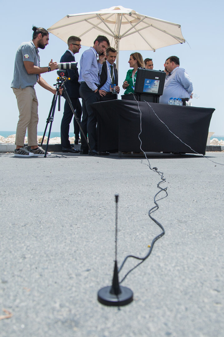
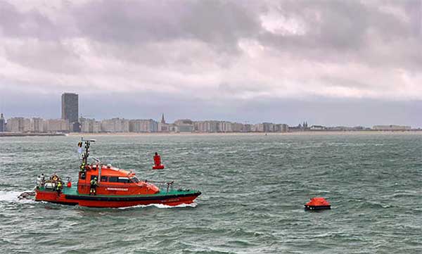
Operation Shark Bait showed how this vital service can quickly trigger a rescue operation and save lives at sea. Despite a grey day and choppy sea conditions, an emergency rescue was initiated in just over three and a half minutes after intrepid “volunteer victim,” Australian broadcaster and explorer Tara Foster, operated her Galileo-enabled SAR beacon from a small life raft buffeted by the waves just offshore from the port of Ostend.
Operation Shark Bait was a specially designed demonstration of the capabilities of the Galileo SAR service that took place around the new state-of-the-art Belgian Maritime Rescue and Coordination Centre (MRCC) in Ostend with an invited audience of VIPs and media. The whole operation was streamed live over YouTube and the Europe By Satellite (EBS) TV service.
The Shark Bait test took just over three and a half minutes to locate the PLB developed under a GSA Horizon 2020 project. (Photo: GSA)
The scenario was simple. Tara was left alone at sea in a small life raft, but with a 406-MHz Cospas-Sarsat personal locator beacon (PLB). On activating the beacon, the stopwatch started. The time to receive the distress signal, compute her position and alert the relevant rescue authorities was recorded. The Belgian fast rescue boat ORKA R6 then dashed out to sea to pick her up.
Subsequently, a NH90 Cayman SAR helicopter from the Belgian 40th squadron was also scrambled to help transfer “injured” Tara to hospital.
Shark Bait was a great success with just 3 minutes 32 seconds elapsing from Tara activating her Galileo-enabled personal locator beacon (PLB) to the moment commanders at MRCC could dispatch the ORKA to her location.
The location, with an initial accuracy of 100 metres, is provided by the Galileo receiver inside the PLB to the Galileo satellites in view. The Galileo satellites then forward this information to the Cospas-Sarsat infrastructure, where the position is validated.
“The PLB used was developed under one of our Horizon 2020 projects and is the first Galileo-enabled beacon on the market,” said Fiammetta Diani, head of market development at the GSA.
Time saver, life saver
The day started at the MRCC in Ostend with a visit to the operations centre, an inspection of the ORKA Fast Rescue Boat and a chance to talk to Tara Foster before she was “castaway” on the waves.
Dries Boodts, deputy nautical director at MRCC, described the role of the center, which has a single focus on safety at sea. “The globe is divided into Search and Rescue Regions (SRRs),” Boodts said. “The MRCC oversees the Belgian maritime region that extends up to 47 miles off the Belgian coast.”
The region includes major shipping lanes and two large offshore wind energy parks. The MRCC deals with around 450 incidents each year involving a range of craft and issues from collisions at sea to war munitions recovery. It can call on an assortment of assets including its own rescue craft, police and navy vessels and the Belgian air force and the MRCC collaborates extensively with authorities in neighbouring countries.
Galileo is Europe’s contribution to upgrading Cospas-Sarsat, the global satellite-based search-and-rescue system. Since its introduction in 1981, Cospas-Sarsat is estimated to have saved 45,000 lives.
The current MEOSAR (Mid-Earth Orbit Search and Rescue) upgrade is based on the EU’s Galileo satellite constellation that carries a dedicated Cospas-Sarsat payload for the 406-MHz distress beacons that give users free access to global system.
The addition of Galileo (and other GNSS satellites) to the system has already enabled a dramatic increase in performance in terms of better accuracy to locate activated distress beacons and vastly improved global coverage.
“With the Galileo system, all parts of the world will be covered at least every 10 minutes — previously this was up to four hours — and guaranteed location accuracy is reduced from 10 to 2 kilometers,” explained Jolanda van Eijndthoven from the European Commission.
As well as the 23 SAR payloads currently provided by Galileo, with more to come, the EU also provides ground infrastructure including MEO Local User Terminals (LUTs) to pick up the signals relayed from the satellites. These LUTs are not just in Europe, and a fourth facility is o be opened soon on La Reunion island to improve coverage across the Indian Ocean.
Return link reassurance
From the end of the year the Galileo system will also provide a Return Link Service (RLS) that will be able to send an acknowledgement to the victim that their distress signal has been received and help is on its way. This new ability to provide reassurance should deliver a valuable psychological lift to victims and further boost survival rates.
“The PLBs developed under our Horizon 2020 projects will be the first ones on the market to have the RLS capability,” said Fiammetta Diani.
Back on dry land, Tara confessed that the simulation had felt very real to her. “The scariest part was the transfer to the helicopter from the rescue boat,” she said. “The winch was like a lift without a floor and very fast! Stepping from the flimsy life raft to the ORKA was also not easy – those waves were high!”
“The operation went just like clockwork,” concluded Paul Flament Head of the Galileo and EGNOS unit at the European Commission’s DG GROW.
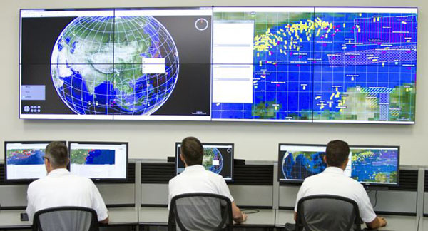
Orolia’s LEOSAR-GEOSAR-MEOSAR (LGM) Mission Control Center (MCC) solutions are now commissioned as Nodal MCCs in Spain and Australia, enabling global distribution of critical search-and-rescue information through the Cospas-Sarsat system.
With the successful commissioning of their Nodal MCCs, Spain and Australia will now be able to share critical information with the U.S. and France, providing worldwide coverage for global search and rescue.
In addition, since they will be authorized to commission other MCCs in their regions, they will also significantly advance the Cospas-Sarsat MEOSAR program.
Orolia’s McMurdo PRISMA MCC features satellite search-and-rescue technology with full LGM capability. It is the commercial solution of choice for search-and-rescue authorities in Norway, the UK and many other countries.
“We’re proud to support the world’s most critical search and rescue operations,” said Steve Ludwig, Orolia’s director of SARSAT Operations. “With Orolia onboard, you can rely on proven solutions in critical environments where failure is not an option. Our PRISMA Mission Control Center systems are the only successfully deployed, Cospas-Sarsat commissioned commercial solutions available, meeting the highest standard for search-and-rescue support.”
The Orolia PRISMA Mission Control Center. (Photo: Orolia)
Orolia has been developing global search-and-rescue programs for nearly 30 years, reaching a major milestone with the Medium-altitude Earth Orbit Search and Rescue (MEOSAR) system in 2011, and completing all global MEOSAR system installations since.
To date, 75 percent of the Earth’s surface is monitored by Orolia’s MEOSAR systems.
Through its McMurdo brand, Orolia has equipped these systems with the latest search-and-rescue technology to increase response times and save more lives worldwide.
The European Commission (EC) has awarded Thales Alenia Space a contract to develop and build an operational ground station on La Reunion Island to track GNSS satellites in medium Earth orbit. The ground station will be an operational part of the Galileo search-and-rescue (SAR) system.
The contract includes one Medium Orbit Local User Terminal (MEOLUT), engineering support and maintenance services for one year, and the hosting site on La Reunion Island.
Using Thales Alenia Space’s powerful and compact MEOLUT Next phased-array solution, the EC and European GNSS Agency (GSA) will improve their contribution to the Cospas-Sarsat system.
Thales Alenia Space is a joint venture between Thales (67 percent) and Leonardo (33 percent).
The ground station will receive and process 406-MHz distress beacon signals from the MEO satellites being tracked, and relay them to the SAR/Galileo network via the French Mission Control Center (FMCC) at the CNES facility in Toulouse. The contract also included the procurement of the best possible hosting site for this ground station.
Image: International Cospas-Sarsat Programme
This MEOLUT Next will enhance the EC’s contribution to the Cospas-Sarsat SAR system by extending its coverage in the South Indian ocean, contributing to worldwide coverage. It complements the three MEOLUTs that are already deployed around Europe — in Larnaca (Cyprus), Maspalomas (Grand Canaria) and Spitzbergen (Norway) — and under responsibility of the GSA.
The MEO system, which replaces the legacy LEO (low Earth orbit) system, is designed to offer a faster response and better location data in near real time for search-and-rescue authorities, using spacecraft and ground facilities to detect and locate signals from the 406-MHz distress beacons.
The MEOLUT Next will also support the second generation of Cospas-Sarsat beacons. The SAR/Galileo site on La Reunion will be fitted with reference and calibration beacons to monitor the performance of the extended SAR ground segment and precisely calibrate MEOLUT measurements.
“Using Thales Alenia Space’s powerful and compact MEOLUT Next phased array solution, the European Commission will benefit from the world’s first spaceborne search & rescue system of this type,” said Philippe Blatt, vice president, Navigation France at Thales Alenia Space. “We are very proud that our advanced technology is now recognized by many customers worldwide. The performance logged by our MEOLUT Next units in service far exceeds requirements, which not only benefits our customer countries, but also makes travel even safer. It’s worth remembering that the Cospas-Sarsat system, operational since 1988, saves some 1,500 lives a year.”
Thales Alenia Space designs, operates and delivers satellite-based systems for governments and institutions, helping them position and connect anyone or anything, everywhere. Since commissioning in 2016, MEOLUT Next has delivered unrivaled performance, detecting distress signals from more than 5,000 kilometers away. Several countries have already chosen or are interested in the technology, including Canada and Togo.
Honeywell has signed an agreement with the Greek Ministry of Maritime Affairs and Insular Policy to upgrade Greece’s search-and-rescue operations using next-generation, satellite-based tracking technology.
Under the agreement, Honeywell will provide the Hellenic Center of Mission Control with eight satellite antennas, three rescue control systems and computer equipment, as well as installation, customization, training and technical support services for seven years.
Using satellite signals, Honeywell’s technology can precisely locate emergency distress beacons and coordinate the deployment of rapid response teams, the company said.
The technology incorporates the COSPAS-SARSAT system, an international satellite-based program for distress alert detection and information distribution.
“By leveraging a network of ground-based antennas and medium earth orbit satellites, we can more precisely locate distress signals from emergency beacons,” said Mehrez Hached, director of business development for Honeywell’s Global Tracking and Search and Rescue business. “This Honeywell solution will help the Greek National Search and Rescue Coordination Center and the Hellenic Coast Guard save lives by quickly identifying aircraft, ships and people in distress regardless of how remote their location.”
Honeywell will install the satellite antennas on sites operated by the Hellenic Air Force and deploy management and surveillance equipment to the Hellenic Coast Guard Headquarters in Piraeus, Greece.
Honeywell’s search and rescue solutions are part of the company’s Safety and Productivity Solutions business. Honeywell provides fixed antennas, terminals, consoles and software applications to quickly locate missing assets on land or at sea and minimize emergency response times.
The company’s software offerings include SARMaster Search, a full-featured incident management application used by frontline operators to coordinate rescue operations, which has helped save tens of thousands of lives.
Honeywell’s tracking technology was incorporated into the European Space Agency’s Galileo search-and-rescue program, a pan-European program designed to dramatically reduce emergency response times using geo-positioning satellites.
Galileo SAR is Europe’s contribution to the COSPAS-SARSAT network, a distress alert detection and information distribution system best known for detecting and locating emergency beacons activated by aircraft, ships and hikers.
By providing COSPAS-SARSAT with the coverage capacity of the Galileo constellation equipped with SAR transponders, Europe is helping to reduce the detection delay of a distress signal from up to several hours to 10 minutes.
A return link, a signal informing the person in distress that the signal has been received and localized, will be added to the system by the end of 2018.
Beacon Awareness Day
The Galileo SAR launch day, April 6, is Beacon Awareness Day in the United States. It’s also named 406 day. 406 stands for 4/06 — the date in U.S. format — and the 406-MHz frequency of the SARSAT beacons.
For Twitter and social media, special hashtags #406day, #406day17 and #savedbythebeacon already exist. The program has added the hashtag #getabeacon to complement it.
The following video about the program focuses on maritime operations, which account for 75 percent of the alerts.
Coming to the Rescue
With Galileo, the time to identify the location of a beacon signal is reduced from several hours to a few minutes. At sea, this makes SAR rescue operations easier thanks to a narrowed “search box,” since the vessel in distress has less time to drift.
On land, the quick acquisition of a precise position enables rescue teams to more quickly reach the operation zone and assist the victims.
In the air, Galileo contributes to fulfilling International Civil Aviation Organization (ICAO) requirements for implementing the next-generation emergency management system Global Aeronautical Distress and Safety System (GADSS). In particular, it enhances location of an airplane in distress, which will be mandatory on Jan. 1, 2021.
The Search And Rescue transponders on Galileo satellites can pick up signals emitted from any 406-MHz distress beacon anywhere in the service coverage area and transmit this information to the dedicated ground stations (MEOLUTs). The SAR/Galileo infrastructure is interoperable with GPS and GLONASS SAR transponders.
Once the beacon is located by the MEOLUTs, the location data is sent to the COSPAS-SARSAT mission control centre (MCC), which distributes it to the relevant rescue centres. The rescue centres, under the responsibility of national competent authorities and administrations, then coordinate the required rescue efforts.
Improving COSPAS-SARSAT
Galileo plays an important role in the Medium Earth Orbit Search And Rescue system of COSPAS-SARSAT (MEOSAR), and provides a ground segment coverage of 40 million square kilometers over Europe as a contribution to MEOSAR global coverage.
Thanks to the advanced European technology used, integration of Galileo into COSPAS-SARSAT improves the system by:
enabling faster detection and localization of distress signals anywhere in the service coverage area, reducing the delay between beacon activation and distress localization
making it easier to find the source of a signal by significantly boosting precision in comparison to the current situation
increasing availability and improving detection of signals in difficult terrain or weather conditions.
The Galileo Search And Rescue service is one of the three services launched in December 2016 with the Initial Services. The SAR service represented just 1 percent of total Galileo program costs, but should result in thousands of lives being saved, according to the head.