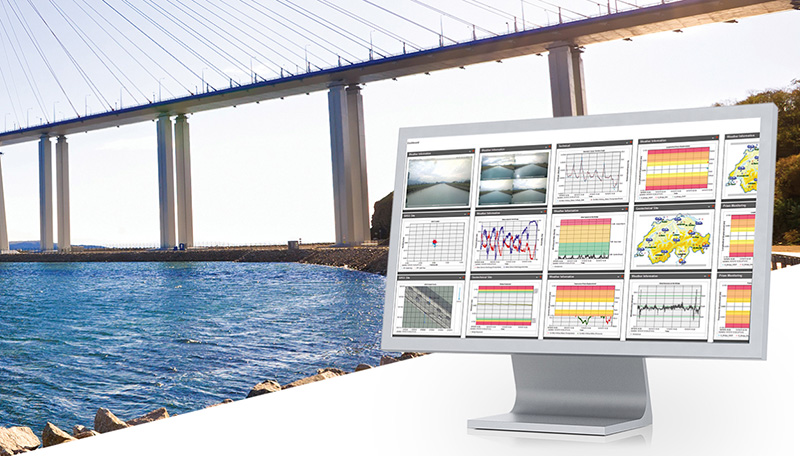
Leica Geosystems has introduced two new additions to its Leica GeoMo deformation monitoring solution: Leica GeoMoS AnyData and GeoMoS API.
Users of the system can now create comprehensible visualizations and customizable reports, which enables powerful sensor data fusion for applications, such as air or water quality monitoring and construction or building management.
With GeoMoS AnyData and GeoMoS API, multiple open interface standards are accessible to provide even more information to projects than just classic geodetic monitoring applications, according to a news release from Leica. The open solution offers flexibility; it is capable of automatically acquiring, processing and distributing intelligent information locally or via the Internet in real time.
Leica GeoMoS integrates, processes and distributes all project data within one software program.
“Monitoring professionals are confronted daily with vast amounts of data collected and provided by a variety of sensors,” said Michael Rutschmann, senior product manager of Structural Monitoring at Leica Geosystems, in the news release. “With these additions to Leica GeoMoS, all information is now easily accessible via web-based visualisation. This is absolutely the most efficient way to convert raw data streams into intelligent information for any user.”
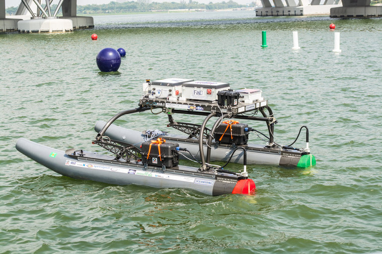
A research team at Florida Atlantic University’s (FAU) College of Engineering and Computer Science has received a $187,000 grant from the Florida Department of Transportation (FDOT) to develop autonomous waterborne vehicles that can assist in bridge inspections.
Although the technology is still in the early stages of development, the long-term aim is that the unmanned surface vehicles (USVs) could be used by the agency to make bridge inspectors’ work safer and more efficient, according to GovTech.com. FDOT currently uses a variety of methods and equipment to inspect and test the sections of the state’s 11,451 bridges that are above water level. However, the only method that can be used to check the sub-surface areas is divers, who search for cracks, erosion, damage and defects that might impact on a bridge’s safety. A high percentage of Florida’s bridges are in corrosive salt water, and divers frequently experience problems with low visibility from silt, sediment, debris and algae, weed or other plant matter.
The team from FAU’s Department of Ocean and Mechanical Engineering have experience in USV research, and won second place at the eighth annual International RoboBoat Competition in Virginia Beach, Va., according to GovTech.com.
Two months into a 12-month project, the team has upgraded a watercraft used for past research projects with a new propulsion system that allows the craft to maintain its position and heading during a bridge scan. The next phase of research will be to equip the craft with an acoustic scanning system that functions in a similar manner to a LiDAR (Light Detection and Ranging) system. By installing the scanner on a mount that can tilt and pan, researchers expect to obtain 3D models of the parts of the bridge that are below the water.
The current vessel is equipped with an automatic control system that uses GPS and a compass to direct the craft toward programmed waypoints, and can keep it steady in a variable current, allowing scanning to take place. Once the acoustic scanner is equipped in September, the team will begin testing the craft’s scanning capabilities on three bridges that have been recommended by FDOT for their diverse representation of the state’s bridge environments.
“These sorts of technologies aren’t really meant to replace wholesale divers and so forth,” the FAU project’s principal investigator, Karl von Ellenrieder, told GovTech.com. “It’s to make their jobs easier, and it’s another tool that can help them do their jobs better. The way I view it is, you would take a vehicle like this and it would allow you to more rapidly scan bridges, and then when you detect a problem, send out a diver to verify the problem through testing. If you’re going to send divers out into strong currents with nasty snakes and stuff, it’s better to have a good sense there’s a problem before you do that.”
Altus Positioning Systems, a Septentrio company, has integrated its APS-GeoPod product with Entegra Technologies’ Crossfire Pro Tablet. This collaboration, targeting the oil and gas, survey, GIS and transportation industries, provides a high-performance tablet-based solution for enabling ultra-precision RTK of sub-meter or centimeter accuracy.
Altus is showcasing the APS-GeoPod and Crossfire Pro tablet, along with the full range of Altus products, at booth A1.060 and outside Booth FG.006 at InterGeo 2014 being held this week in Berlin, Germany.
According to Altus CEO Neil Vancans, the Altus APS-GeoPod and the Entegra Crossfire Pro Tablet provide a combination of precision, performance and features that make it ideal for energy services, land surveys and other GIS-related applications.
APS-GeoPod is a compact GPS/GLONASS RTK and DGNSS receiver that adds high-precision RTK positioning to USB-compatible tablet PCs. “This unique product gives users the convenience of adding RTK precision to any on-board application on mobile devices geared to the field service professional,” Vancans said.
The Entegra Crossfire Pro tablet. Photo: Altus Positioning Systems
APS-GeoPod features include:
Compact dual-frequency GNSS module
Low power consumption (<1 Watt)
USB 2.0 interface
Internal L1 GPS/GLONASS antenna
NMEA integration with GIS software
The Crossfire Pro tablet features the multi-touch interface and communication capabilities of smartphones, the large display and ergonomics of consumer tablets, and the daylight-readable screen and durability of rugged tablets. Safety features include UL 1604 Class I/Division II certification for operation in hazardous locations. To users, Crossfire Prodelivers a customizable tablet for exacting daily activities, resulting in greater efficiencies, response times, productivity and customer service levels, the companies said.
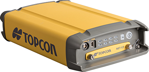
Topcon’s NET-G5 receiver and CR-G5-C antenna. Photo: Topcon
Topcon Positioning Group announces the next generation of its geodetic GNSS reference receivers and antennas — the NET-G5 receiver and CR-G5-C antenna.
The announcement was made at InterGeo 2014, being held this week in Berlin.
Using Vanguard and Universal Tracking technologies, the NET-G5 receiver incorporates 452 channels capable of tracking the full GNSS signal spectrum, including modernized GPS, GLONASS, Galileo, Beidou, QZSS and SBAS signals. Universal Tracking has the advantage and capability to assign any visible GNSS signal to any available receiver channel.
The NET-G5 receiver is designed to work as a complete system connectivity solution, with built-in Bluetooth and Wi-Fi, for flexible wireless communications or via standard Ethernet, serial and USB connections. Other features include: High-precision code and carrier phase measurements up to 100 Hz; Power over Ethernet (PoE) and an all new Topcon receiver web interface with advanced receiver management features.
“Comprehensive communication support, advanced web-server capability, and extended operating times are among the new features supported on the NET-G5. Coupled with the CR-G5-C antenna, the new systems provides a powerful, interference protected network solution,” said Charles Rihner, vice president of the Topcon GeoPositioning Group.
“Whether you are installing an all-new GNSS network infrastructure, expanding or upgrading an existing network, looking for a premium campaign receiver or stand-alone RTK base station, the high-performance NET-G5 is designed to provide the most advanced reference station solution available in the market,” Rihner said.
The CR-G5-C is a full-wave geodetic choke-ring antenna designed to address evolving requirements for reference networks and infrastructure monitoring applications. “The CR-G5 antenna has excellent vertical phase center stability over the entire GNSS frequency band, providing superior performance in tracking low elevation satellite signals,” Rihner said. “This new model employs cavity filter technology to more aggressively combat radio frequency interference in difficult environments.”
GPS World staff will be reporting from InterGeo October 7-9. The massive trade show, held this year in Berlin, is considered the world’s leading conference trade fair for geodesy, geoinformation and land management. With more than 16,000 visitors from 80 countries, it is one of the key platforms for industry dialogue.
Staff members attending include GPS World Editor and Publisher Alan Cameron, Survey/GIS Editor Eric Gakstatter, and Digital Editor Joelle Harms. All three are accepting meeting invitations for companies interested in discussing their products and services. Contact [email protected].
VIDEO PLAYLIST
PHOTOS
Photo: GPS World
Topcon demonstrates its LN-100W, an update to its line of 3D positioning systems designed for one-operator layout. Photo: GPS World
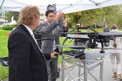
German-based Multirotor by servicedrone is a UAV for professional 3D orthography. Photo: GPS World
Attendees listen to a presentation on the show floor at InterGeo held October 7-9 in Berlin. Photo: GPS World
Attendees watch UAV demonstrations at the conference’s flight zone. Photo: GPS World
Attendees take a look at one of the many UAVs seen at InterGeo 2014 in Berlin. Photo: GPS World
German-based Moskito GIS GmbH displayed a model from its 5 Power GIS. Photo: GPS World
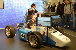
BRS Motorsport Formula Students from Bonn-Rhein-Sieg University of Applied Sciences showcase their simulator, sponsored by CPA ReDev. Photo: GPS World
Riegl debuted and demonstrated its RiCOPTER UAV with LiDAR Integration. Photo: GPS World
At dusk the night before the conference the moon overlooks the Brandenburg Gate, an 18th century arch in Berlin and one of its most well-known landmarks. Photo: GPS World
Summary: UAVs (unmanned aerial vehicles) are taking over the surveying industry, thanks to their ever-improving sensors and the fact that they are getting lighter and can therefore remain in the air for longer. They complete surveying and inspection tasks that would otherwise be difficult to tackle, and do so with impressive cost-efficiency. UAV trends and technology will be among the focal points at the InterGeo conference in Berlin in early October.
Our correspondents will return with a fresh report, moderated by GPS World Editor and Publisher Alan Cameron and Survey Scene Editor Eric Gakstatter.
Soil Instruments Limited has partnered with Juniper Systems Limited to provide a geotechnical monitoring system using rugged computers and geotechnical engineering instrumentation to improve field activities in the structural and earthworks industry.
Soil Instruments’ Digital Bluetooth Inclinometer Systems are now exclusively using Juniper Systems’ Archer 2 rugged computer, which provides superior readings and data capture, Soil Instruments said. Soil Instruments’ inclinometers are specially designed instruments that provide high accuracy and resolution measurement for the monitoring of structural and earth deformations, movements or settlement.
“The rugged Archer 2 handheld computer pairs beautifully with Soil Instruments’ Digital Inclinometers, providing more accurate readings and data capture than could ever be achieved previously in this industry,” said Simon Bowe, general manager of Juniper Systems Limited.
Juniper Systems’ Archer 2 rugged computer is connected to the inclinometer system via Bluetooth wireless technology. Within the borehole an angular reading is produced by the engineer via the Read button on the Archer 2 screen, which triggers the inclinometer sensors to take the reading.
Those readings are then instantly transmitted via the Bluetooth connection to the Archer 2, captured on-screen and saved in the Archer 2’s database, to be reviewed for accuracy or other needed data measurements. Long days of field work remain productive because of the 512MB of RAM and 8GB of flash storage in the Archer 2.
Data can also be transmitted back to base quickly and accurately via the 3.75G modem in the Archer 2, an action which many other inclinometers cannot complete. At the end of the day, data can be downloaded or transmitted for subsequent comparison against all previous borehole runs, allowing analysis of lateral ground movements over time.
“Soil Instruments has found the perfect field computer to match with our Digital Inclinometer Systems”, said Mike Ziolek, sales and marketing director for Soil Instruments. “The Archer 2 really gives our customers an edge by providing field readings more quickly and clearly than any other inclinometer system.”
The physical features of the Archer 2 and the Inclinometer Systems are highly compatible. The Archer 2’s IllumiView high-visibility display is extra large, incredibly bright, and overpowers glaring sunlight. The backlit LCD easily adjusts to either portrait or landscape orientation, and is glove-friendly and extremely scratch-resistant.
The Archer 2 has ultra-rugged construction with IP68 protection against water and dust, and is shockproof against multiple drops. The intelligent Li-ion battery can operate up to 20 hours on one charge and is hot-swappable in the field. The high-sensitivity GPS/GLONASS/SBAS receiver is highly useful for field work.
The ruggedness of the Archer 2 compliments the secure connections on Soil Instruments’ Inclinometer Systems. The inclinometer probes are mounted to a cable using an advanced waterproof moulding compound, which eliminates field connectors. This means that no on-site connectors get broken or contaminated while working in the field.
Juniper Systems Limited will be demonstrating its superior, rugged handheld computers at InterGeo at Messe Berlin, Germany, October 7-9, in Hall 2.1 on Stand A2.039.
Handheld Group, a manufacturer of rugged mobile computers, has launched the Nautiz X8 rugged PDA. The Nautiz X8 is a handheld computer with superior processing power, screen performance and battery life, the company said. It is built for tough field conditions primarily in GIS, land surveying, public safety, forestry and the military.
Photo: Handheld Group
The Nautiz X8 is built to enable efficient and reliable data collection in tough environments. It has an IP67 ingress protection rating, which means it offers complete protection against dust and sand and can withstand immersion in water. It also meets stringent MIL-STD-810G military test standards for overall durability and resistance to humidity, shock, vibration, drops, salt and extreme temperatures.
The Nautiz X8 features a high-performance Texas Instruments 4470 dual-core 1.5 GHz processor. It has 1 GB of RAM, 4 GB of iNAND Flash and a 5200 mAh Li-ion battery that lasts up to 12 hours on a single charge. It comes with a choice of operating systems — Android 4.2.2 or Windows Embedded Handheld 6.5.3.
The device has a large 4.7-inch ultra-bright capacitive multi-touch screen with chemically strengthened Asahi Dragontrail glass, offering users brightness and protection in any field condition. The unit has an ergonomic design and weighs 490 grams (17.3 ounces).
The Nautiz X8 has a dedicated u-blox GPS receiver, Bluetooth 2.0 and 802.11b/g/n WLAN functionality, as well as connectivity through GSM/UMTS or CDMA phone data transmission. A built-in 8-megapixel camera with autofocus and an LED flash lets users capture visual data quickly and easily. This handheld also features an open architecture and an extension cap system that allows for additional hardware connections such as sensors, radios and other add-ons.
Orders for the new Nautiz X8 can be placed immediately. First deliveries will begin in November.
The Nautiz X8 rugged handheld will be shown first at WEFTEC in New Orleans, followed by InterGeo in Berlin.
Septentrio and Altus will be presenting their high-performance RTK systems at ION GNSS+ 2014. Attendees are invited to learn more at:
The Triple-frequency Multi-system RTK Engine for Challenging Environments (Session A1 room 18, Wed. 9/10 @11:48)
Gap Bridging in Precise Point Positioning (Session B6 room 19, Fri. 9/12 @3:20)
High-performance RTK provides accurate positioning
in urban environments or under dense canopies
while suffering high ionosphere activities or
when coping with sparse networks
for maintaining a smooth transition during outages
Plus, there is no baseline impact, even at greater than 40 kilometers. Visit booth 318/320 in the Exhibit Hall to learn more about the technology behind the performance.
Topcon Positioning Group has released two unmanned aerial systems (UAS) for mapping — the Sirius Pro and Sirius Basic. Both systems are designed to produce the most accurate solutions for the automated mapping of a wide range of sites — regardless of terrain — including construction sites, mines and quarries, and for use in land surveying, power line and pipeline inspection as well as precision agriculture field mapping.
The fixed-wing systems resulted from a partnership with MAVinci GmbH, a UAS development company with which Topcon recently entered into a worldwide distribution agreement.
“The Sirius Pro system is unique to the UAS marketplace. Instead of using traditional ground control points, Topcon combines RTK (real-time kinematic) GNSS solutions with precision timing technology to provide more accurate mapping results when compared to other products,” said Eduardo Falcon, executive vice president and general manager for the Topcon GeoPositioning Solutions Group.
“The system is easy to use and rugged — allowing operators to use a simple hand launch with precise automatic operation from takeoff to landing, and it can be flown safely in nearly all weather conditions,” Falcon said.
The Topcon Sirius Basic is an entry-level system offering many of the advantages of the Sirius Pro with options to upgrade. “The Sirius Basic shares the same hardware components of the Pro model, providing affordability with the same level of sturdiness and ease of operation,” said Falcon. “Additionally, when the need arises for the increased accuracy and productivity of the Pro system, a simple upgrade makes the transition practically effortless.”
Both systems also offer autopilot assisted manual control, automatic flight planning and safety features.
Trimble has introduced an integrated GNSS reference receiver, broadband seismic recorder and a force-balance triaxial accelerometer for infrastructure and precise scientific applications.
The Trimble SG160-09 SeismoGeodetic system provides real-time GNSS positioning and seismic data for earthquake early warning and volcano monitoring as well as infrastructure monitoring for buildings, bridges, dams, as well as other natural and manmade structures.
The Trimble SG160-09 SeismoGeodetic system combines the innovation, reliability and data integrity of both the Trimble and REF TEK brands into a single instrument, Trimble said. The system integrates seismic recording with GNSS geodetic measurement in a single compact, ruggedized package. It includes a low-power, 220-channel GNSS receiver powered by the latest Trimble-precise Maxwell 6 technology and supports tracking of both GPS and GLONASS signals plus the Galileo E1 frequency.
The system includes both the SG160-09 and utilization of Trimble’s CenterPoint RTX correction service, which provides on-board GNSS point positioning. Based on Trimble RTX technology, the service utilizes satellite clock and orbit information delivered over cellular networks or Internet Protocol (IP), allowing cm-level position displacement tracking in real-time anywhere in the world. The SG160-09 system will be available for purchase without the RTX correction service for those applications using real-time kinematic (RTK) positioning.
The seismic recording sensor includes an ANSS Class A, low-noise, force-balance triaxial accelerometer with the latest, low-power, 24-bit A/D converter, which produces high-resolution seismic data. The internally built accelerometer has +/- 4g full scale output, large linear range, high resolution and sensitivity, which makes it ideal for both portable and permanent deployment. The SG160-09 processor acquires and packetizes both seismic and geodetic data and transmits it to system operators using an advanced, error-correction protocol with back-fill capability providing data integrity between the field and the processing center.
The SG160-09 system is ideal for earthquake early warning studies and other hazard mitigation applications, such as volcano monitoring, building, bridge and dam monitoring systems. The SG160-09 system features a variable size industrial grade USB drive to support real-time telemetry data transmission. In the event of a telemetry link outage, the data is stored on the USB drive and can be re-transmitted to the centralized processing station as soon as the communication link comes back up, allowing no data loss during the system operation.
The Trimble SG160-09 system is optimized for field use with instrument mounted or externally mounted GNSS antenna configurations. The lightweight yet rugged SG160-09 consumes very little power and can be used for projects with remote connectivity and in extreme weather conditions. Because the SG160-09 combines both GNSS and strong motion in a single instrument, site installation time is reduced, data communications flow through a single pathway, and station power infrastructure is streamlined, making the SG160-09 a cost competitive solution compared to other systems on the market today. It has an IP67 rating, which means it is sealed against dust and can be submerged in water up to a meter for approximately 30 minutes. The SG160-09 also meets MIL-STD 810F standard for drops, vibration and temperature extremes.
“The SG160-09 is another example of Trimble’s on-going focus in GNSS and seismic technology for the scientific and engineering communities,” said Ulrich Vollath, general manager for Trimble’s Infrastructure Division. “Trimble has developed a combined state-of-the-art GNSS receiver with a high-dynamic range, low-noise accelerometer that provides dynamic monitoring with the flexibility required for today and tomorrow’s challenges.”
The Trimble SG160-09 SeismoGeodetic system is expected to be available in the fourth quarter of 2014.
Trimble has introduced a new version of its office software suite used by surveyors and geospatial professionals for processing and analyzing geospatial data. Trimble Business Center Version 3.21 introduces new coordinate reference systems and a specialized Advanced Drafting module, which enables faster project turnaround and better decision making.
The optional Advanced Drafting module adds highly customizable templates and simplified selection tools, which are designed to reduce the time required to generate high-quality deliverables, such as geospatial maps and corridor cross-sections. Now, professionals working on road, pipeline, and railway projects can achieve efficiency gains through the software’s new automated cross-section plotting functionality.
Also included in the new module is the ability to create 3D PDFs so that team members and clients can collaborate from any computer or mobile device using Adobe Reader software.
“Trimble Business Center is the enterprise solution for surveyors and geospatial professionals to produce high-quality deliverables,” said Alain Samaha, business area director of GIS and Software for Trimble’s Geospatial Division. “These new capabilities demonstrate the continued evolution of our software portfolio to provide customers with an end-to-end solution to fulfill their client’s high-end requirements in the most efficient way.”