The Esri User Conference, which usually takes place in San Diego in July, will this year be held virtually.
“As a result of the coronavirus disease 2019 (COVID-19) crisis, we are making the decision to move the 2020 Esri User Conference in San Diego to a virtual format. This is a great disappointment to me personally, as I know it will be for many of you,” Esri CEO Jack Dangermond told those planning to attend in an April 22 e-mail.
The following is an outline of Esri’s current plan, with more information available in the Esri UC FAQs:
The event will take place July 13–15, 2020.
The plenary session, technical workshops and Esri Showcase will be virtual, featuring many demonstrations and live discussions during the conference.
There will be many opportunities for networking, collaboration and real-time interaction with Esri experts and staff.
User presentations and the map gallery will be featured digitally.
A library of recorded sessions and demos will be created and kept available as an ongoing resource.
Registration will be complimentary for all Esri customers who are current on their maintenance or subscription.
“Forty years ago this month, we had our first User Conference in Redlands, California, with only a handful of participants,” Dangermond wrote. “While initially no one was quite sure of what the outcome would be, the event started an ongoing tradition where Esri and our users would come together, share our work, learn and create a community of common interests.
“That first meeting on the Esri campus provided the groundwork for the annual event at which thousands of professionals from every corner of the globe meet one another, share inspiring examples of work and learn from each other’s experiences.
“While we can’t replicate the experience of being together in person, we will do our best to create an amazing event that will continue to move you and our community forward. One of the benefits of going with a virtual format will be that organizations will be able to send an unlimited number of attendees.”
Doug Flewelling, Ph.D., gives an overview of the University of Redland‘s master’s degree program for GIS at the 2017 Esri User Conference, which took place July 10-14 in San Diego, California. The program is specifically designed for is professionals in the field looking to further their careers, as well as international students.
Teledyne Optech Business Unit Manager Albert Iavarone talks about the features of the Polaris Terrestrial Laser Scanner Series. The unit, which has a touchscreen display, was showcased at the 2017 Esri User Conference, which took place July 10-14 in San Diego, California. Iavarone also touches on the Maverick mobile scanner.
The Trimble Catalyst software-defined GNSS receiver for Android devices is now available through Trimble’s global distribution network. Trimble’s Gareth Gibson gives an overview of its features at the 2017 Esri User Conference, which took place July 10-14 in San Diego, California.
Brandon Jarratt took plenary attendees behind the scenes of city creation in Zootopia, using Esri CityEngine. (Photo: Esri)Brandon Jarratt, Disney.
Brandon Jarratt took GIS professionals behind the scenes of animated city creation at the Esri User Conference, being held this week in San Diego.
Jarratt served as general technical director for Disney’s Zootopia, which won the 2016 Academy Award for Best Animated Feature Film. Jarrett took the stage during the plenary session to describe how the Zootopia team used Esri CityEngine software to create the complex city that serves as the backdrop for the movie.
Jarratt said Disney animated features need three elements: compelling stories, appealing characters and believable worlds. That’s believable worlds, not realistic worlds.
Disney animated movie elements. (Photo: T. Cozzens)
In this case, the complex city of Zootopia had to be designed from the ground up as a complex city with various districts designed to accommodate the vast array of animal species.
In the world of Zootopia, humans don’t exist. Transportation systems, houses, streets and services need to accommodate animals as tall as giraffes and as small as a shrew. To meet these challenges, the designers turned to Esri CityEngine and its multi-scaling feature.
The Zootopia world also needed to incorporate various habitats, or in this case, districts. At the center a large complex city dominates.
The four burroughs of Zootopia. (Image: Disney)
CityEngine was used in the creation of the city in Big Hero 6 as well. In Big Hero 6, the base city geography used was San Francisco, upon which Japanese-style buildings were placed. In all, 80,000 buildings were incorporated into San Fransokyo.
San Fransokyo in Big Hero 6. (Image: Disney)
Zootopia, on the other hand, was built from scratch — including the terrain. The team started with research of various landscapes to create a basemap.
Zootopia concept map. (Photo: T. Cozzens)
At the city-building stage, CityEngine’s custom tool was used to lay down streets.
Buildings were designed for each district. The building styles couldn’t be repeated too often, or the city would look unrealistic, Jarratt said. The designers used carefully calibrated mix rules to keep the cities lively.
The desert area of Sahara Square is make of 61,000 parts, including buildings, wall segments and palm trees. (Image: Disney)
The ability in CityEngine to change the makeup of a city, adjusting the frequency of the various parts, made it easy for the illustration team to meet the art director’s requirements. When he wanted more skyscrapers, or buildings of a certain design, the team was able to provide new concept images the same day.
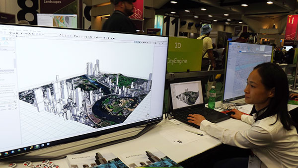
Zooptopia being built in Esri CityEngine. (Photo: T. Cozzens)
Esri’s CityEngine GIS technology is used by city planners to design our future smart cities. “It’s so similar to how city planners create real cities,” said Esri President Jack Dangermond. He then presented Jarratt with Esri’s first-ever Best Animated Feature Using GIS award.
Brandon Jarratt took plenary attendees behind the scenes of city creation in Zootopia, using Esri CityEngine. (Photo: Esri)Brandon Jarratt, Disney.
Brandon Jarratt took GIS professionals behind the scenes of animated city creation at the Esri User Conference, being held this week in San Diego.
Jarratt served as general technical director for Disney’s Zootopia, which won the 2016 Academy Award for Best Animated Feature Film. Jarrett took the stage during the plenary session to describe how the Zootopia team used Esri CityEngine software to create the complex city that serves as the backdrop for the movie.
Jarratt said Disney animated features need three elements: compelling stories, appealing characters and believable worlds. That’s believable worlds, not realistic worlds.
Disney animated movie elements. (Photo: T. Cozzens)
In this case, the complex city of Zootopia had to be designed from the ground up as a complex city with various districts designed to accommodate the vast array of animal species.
In the world of Zootopia, humans don’t exist. Transportation systems, houses, streets and services need to accommodate animals as tall as giraffes and as small as a shrew. To meet these challenges, the designers turned to Esri CityEngine and its multi-scaling feature.
The Zootopia world also needed to incorporate various habitats, or in this case, districts. At the center a large complex city dominates.
The four burroughs of Zootopia. (Image: Disney)
CityEngine was used in the creation of the city in Big Hero 6 as well. In Big Hero 6, the base city geography used was San Francisco, upon which Japanese-style buildings were placed. In all, 80,000 buildings were incorporated into San Fransokyo.
San Fransokyo in Big Hero 6. (Image: Disney)
Zootopia, on the other hand, was built from scratch — including the terrain. The team started with research of various landscapes to create a basemap.
Zootopia concept map. (Photo: T. Cozzens)
At the city-building stage, CityEngine’s custom tool was used to lay down streets.
Buildings were designed for each district. The building styles couldn’t be repeated too often, or the city would look unrealistic, Jarratt said. The designers used carefully calibrated mix rules to keep the cities lively.
The desert area of Sahara Square is make of 61,000 parts, including buildings, wall segments and palm trees. (Image: Disney)
The ability in CityEngine to change the makeup of a city, adjusting the frequency of the various parts, made it easy for the illustration team to meet the art director’s requirements. When he wanted more skyscrapers, or buildings of a certain design, the team was able to provide new concept images the same day.
Zooptopia being built in Esri CityEngine. (Photo: T. Cozzens)
Esri’s CityEngine GIS technology is used by city planners to design our future smart cities. “It’s so similar to how city planners create real cities,” said Esri President Jack Dangermond. He then presented Jarratt with Esri’s first-ever Best Animated Feature Using GIS award.
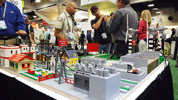
The 2017 Esri User Conference, the mecca of geographic information systems (GIS) in the U.S., is taking place July 10-14 in San Diego, California. This year, the theme is “The Science of Where.”
The conference is designed to give attendees practical advice and hands-on experience with GIS tools from Esri and other companies, as well as share ideas and best practices for improving our world through maps.
The event encompasses 16,000 GIS users, managers and developers; 300 moderated sessions; 450 hours of technical training; and 300 software vendors.
The Expo Hall at the Esri User Conference. (Photo: T. Cozzens)A wall in the SDCC lobby is dedicated to tracking the upcoming full eclipse across the U.S. (Photo: T. Cozzens)
Drone-maker 3DR is teaming up with Esri to integrate 3DR’s Site Scan software with Esri Drone2Map.
3DR made the announcement at the Esri User Conference, held last week in San Diego.
Designed for the field professional, Site Scan is an intuitive, powerful and open aerial data capture and analytics platform that delivers an end-to-end solution ready-made for existing mapping and survey workflows, 3DR said in a news release. With Site Scan and Drone2Map, Esri customers can safely, quickly and easily conduct surveys with the Solo smart drone and effortlessly deliver that data to ArcGIS and ArcGIS Online.
“Aerial data capture technology is bringing about a revolution in surveying and mapping,” said Lawrie Jordan, Director of Imaging and Remote Sensing at Esri. “We are thrilled to partner with 3DR to streamline the creation of professional imagery products with Site Scan and Drone2Map for ArcGIS. Together we will accelerate the development and use of remote sensing across all industries.”
Site Scan automatically calculates a flight plan and Solo autonomously executes both flight and image capture. Images are processed and integrated with Esri Drone2Map to create high-resolution georeferenced maps and digital elevation models to share as tile or feature services in ArcGIS and ArcGIS Online.
“Capturing site data today is costly, time consuming and often dangerous. Drones can easily go where it’s inefficient or unsafe for field personnel, making it easier to accurately measure our world so we can better analyze and manage it,” said Chris Anderson, CEO of 3DR. “We’re delighted to partner with such a great industry leader and integrate Site Scan with Esri Drone2Map. Together, we offer a complete solution for site capture that will help our customers create maps that tell stories, record change over time and perform analysis all while saving time, saving money and keeping humans out of harm’s way.”
Site Scan makes it safer and easier than ever for people in land management, GIS, mapping, energy, infrastructure and related fields to aggregate and process multiple forms of aerial imagery and data and easily incorporate them into the Esri tools they use every day, 3DR said.
Engineering and survey firm McKim & Creed, based in Fort Worth, Texas, is one customer. “Utilizing the 3DR Solo and SiteScan allowed McKim & Creed to confidently collect accurate spatial information in dangerous and demanding environments where it would have been difficult to use traditional survey methods,” said Christian Stallings, R&D Manager at McKim & Creed.
“Using Esri’s Drone2Map software, surveyed ground control and 3DR’s Solo, we were able to collect detailed elevation information and high-resolution orthophotography over a dredging containment pond operated by the United States Army Corps of Engineers (USACE). This approach proved to be accurate and kept people out of harm’s way — which would only be achievable using this approach,” Stallings said.
3DR designed Site Scan as an open and extensible platform. On the hardware side, the Solo smart drone has open gimbal and accessory bays, which give both 3DR and their global technology partners the ability to integrate additional cameras and sensors.
Additionally, Solo firmware updates optimize the drone’s flight profile and performance. On the software side, 3DR continually updates the Site Scan application so that customers can take advantage of the most recent and advanced analytics technologies.
With Site Scan, even users new to drone technology will fly with confidence from day one. The Site Scan app includes 3DR’s airspace safety information software, which alerts users if they’re about to fly in restricted airspace. They can then pull up a map of the area with all restrictions around them clearly marked.
To support enterprise customers further, 3DR offers Success Services, including the Premier Success Plan. Included with their purchase of Success Services, all Site Scan users will have access to experts on Site Scan and Solo. They will also have a Solo overnight replacement guarantee should anything go wrong with one of their drones.
Site Scan with Solo Enterprise is available immediately for order on store.3dr.com, priced at $3249 with a monthly service fee of $499 paid annually with a 12-month commitment.
Esri has launched two new ArcGIS apps for field operating efficiency at the Esri User Conference, being held June 27–July 1 in San Diego. Attendees can see live demonstrations and experiment with Drone2Map for ArcGIS and Survey123 for ArcGIS.
“These two apps are already becoming game changers,” said Esri President Jack Dangermond. “What we’ve done is make it much easier for our users to collect data, including imagery, and then right away start working with that data — mapping, analyzing, sharing—in ArcGIS.”
Drone2Map for ArcGIS provides safe and affordable imagery on demand—a benefit especially useful to people who work in land analysis or infrastructure inspection and those monitoring events such as natural disasters and environmental change. Drone2Map takes still imagery captured by a drone and quickly turns it into high-quality 2D and 3D products in ArcGIS.
The app detects camera and sensor parameters and intelligently applies appropriate defaults. Its rapid-process capability allows teams in the field to be sure they’ve captured everything they need to avoid costly return trips. The imagery products created using Drone2Map can be used for analysis in ArcGIS Online and ArcGIS Pro to support informed decision-making.
Esri Survey123.
Survey123 for ArcGIS is a simple yet powerful form-centric field data gathering solution that makes it possible to create, share, and analyze surveys in three easy steps. With Survey123, paper forms are effectively transformed into digital surveys. Surveys, from simple to sophisticated, are authored and then shared in ArcGIS.
Using the Survey123 mobile app for iOS, Android or Windows, teams in the field capture survey results with their smartphones and tablets, even in disconnected environments. Data captured in the field is immediately available for analysis in ArcGIS to help users make better decisions. Survey123 is a versatile data collection solution already popular with people in public health, education, public works, disaster response, and humanitarian agencies.
Attendees of the Esri User Conference can see live demos and get hands-on experience with both of these new apps along with hundreds of other solutions designed to enable a smarter world.
]The annual event attracts 16,000 geographic information system (GIS) users, managers, and developers. It offers 300 moderated sessions, 450 hours of technical training, access to 300 software vendors, inspirational keynotes, and one-on-one sessions with Esri technical and professional support staff. See more of GPS World’s coverage.
Today at the Esri User Conference, 3DR announced that it has teamed up with Esri to integrate 3DR’s Site Scan with Esri Drone2Map.
Designed for the field professional, Site Scan is an intuitive, powerful and open aerial data capture and analytics platform that delivers an end-to-end solution ready-made for existing mapping and survey workflows, 3DR said in a news release. With Site Scan and Drone2Map, Esri customers can safely, quickly and easily conduct surveys with the Solo smart drone and effortlessly deliver that data to ArcGIS and ArcGIS Online.
“Aerial data capture technology is bringing about a revolution in surveying and mapping,” said Lawrie Jordan, Director of Imaging and Remote Sensing at Esri. “We are thrilled to partner with 3DR to streamline the creation of professional imagery products with Site Scan and Drone2Map for ArcGIS. Together we will accelerate the development and use of remote sensing across all industries.”
Site Scan automatically calculates a flight plan and Solo autonomously executes both flight and image capture. Images are processed and integrated with Esri Drone2Map to create high-resolution georeferenced maps and digital elevation models to share as tile or feature services in ArcGIS and ArcGIS Online.
“Capturing site data today is costly, time consuming and often dangerous. Drones can easily go where it’s inefficient or unsafe for field personnel, making it easier to accurately measure our world so we can better analyze and manage it,” said Chris Anderson, CEO of 3DR. “We’re delighted to partner with such a great industry leader and integrate Site Scan with Esri Drone2Map. Together, we offer a complete solution for site capture that will help our customers create maps that tell stories, record change over time and perform analysis all while saving time, saving money and keeping humans out of harm’s way.”
Site Scan makes it safer and easier than ever for people in land management, GIS, mapping, energy, infrastructure and related fields to aggregate and process multiple forms of aerial imagery and data and easily incorporate them into the Esri tools they use every day, 3DR said.
Engineering and survey firm McKim & Creed, based in Fort Worth, Texas, is one customer. “Utilizing the 3DR Solo and SiteScan allowed McKim & Creed to confidently collect accurate spatial information in dangerous and demanding environments where it would have been difficult to use traditional survey methods,” said Christian Stallings, R&D Manager at McKim & Creed.
“Using Esri’s Drone2Map software, surveyed ground control and 3DR’s Solo, we were able to collect detailed elevation information and high-resolution orthophotography over a dredging containment pond operated by the United States Army Corps of Engineers (USACE). This approach proved to be accurate and kept people out of harm’s way — which would only be achievable using this approach,” Stallings said.
3DR designed Site Scan as an open and extensible platform. On the hardware side, the Solo smart drone has open gimbal and accessory bays, which give both 3DR and their global technology partners the ability to integrate additional cameras and sensors.
Additionally, Solo firmware updates optimize the drone’s flight profile and performance. On the software side, 3DR continually updates the Site Scan application so that customers can take advantage of the most recent and advanced analytics technologies.
With Site Scan, even users new to drone technology will fly with confidence from day one. The Site Scan app includes 3DR’s airspace safety information software, which alerts users if they’re about to fly in restricted airspace. They can then pull up a map of the area with all restrictions around them clearly marked.
To support enterprise customers further, 3DR offers Success Services, including the Premier Success Plan. Included with their purchase of Success Services, all Site Scan users will have access to experts on Site Scan and Solo. They will also have a Solo overnight replacement guarantee should anything go wrong with one of their drones.
Site Scan with Solo Enterprise is available immediately for order on store.3dr.com, priced at $3249 with a monthly service fee of $499 paid annually with a 12-month commitment.
The 2016 Esri User Conference, the mecca of geographic information systems (GIS) in the U.S., takes place June 28 to July 1 in San Diego, California. The conference is designed to give attendees practical advice and hands-on experience with GIS tools from Esri and other companies, as well as share ideas and best practices for improving our world through maps.
The event encompasses 16,000 GIS users, managers and developers; 300 moderated sessions; 450 hours of technical training; and 300 software vendors.
CoreLogic has expanded its location-based intelligence data with the addition of structure footprint information to its other parcel and property characteristics data offerings.
CoreLogic is a global property information, analytics and data-enabled services provider. The company made the announcement at the 2016 Esri User Conference, being held in San Diego, California, June 27-July 1.
CoreLogic Structure Footprint enables accurate roof-top geocoding and identifies the location and outline of relevant structures on a parcel, including all known sub-addresses, to provide a more granular and precise property description.
Street, parcel and structure geocoding appear on a single map. (IMAGE: CoreLogic)
CoreLogic residential and commercial structure footprint data covers more than 35 million rural and urban parcels throughout the U.S, including two-thirds of the largest 50 metro areas. When combined with other CoreLogic proprietary property data, including business financial health, natural hazard risks, occupancy information and building characteristics, the added structure footprint data provides a more complete picture of a property than was previously available.
Accurate location data is a critically important factor for planning and operations in oil and gas, insurance, geo-commerce and other industries that need to understand what type of structures and building characteristics are associated with property addresses.
The addition of structure footprint data complements the existing CoreLogic property characteristic data, which details attributes in 150 distinct categories that provide location intelligence on everything from zoning and land use to details about roof type and number of bedrooms.
“The addition of this property data layer, which identifies individual structures within a single parcel, can improve efficiencies and risk segmentation for everything from geo-commerce to insurance,” said Steve Brewer, senior vice president of Insurance and Spatial Solutions at CoreLogic. “It’s exciting to see this level of granularity added to location intelligence that was previously not available — granularity that can be used in a variety of decision-making situations including natural hazard risk assessment, marketing, asset management and claims processing.