A bill moving through the U.S. Congress would impose a five-year ban on United States government purchases of drones manufactured or assembled in China, reports The Associated Press. The measure reflects bipartisan concerns that the unmanned aerial vehicles (UAVs) made in China could facilitate Chinese spying on critical infrastructure.
Major commercial and consumer UAV-maker company DJI is based in Shenzhen, China. Many of its small, low-altitude drones are employed by local and regional government users in law enforcement, emergency response and surveying. The ban could affect police departments that rely on federal funds for equipment. In 2020, the Department of Homeland Security halted such grants for Chinese-made drones.
Chinese-made components, including GNSS receivers and inertial sensors, are not addressed in the bill, and the Pentagon has acknowledged that many components for non-Chinese-company drones are made in China.
While the ban wouldn’t go into effect until 2023, many federal agencies have already imposed temporary restrictions on the use of Chinese drones. The Interior Department had flown more than 11,000 drone missions before January, when the agency temporarily grounded its fleet of more than 500 DJI drones over cybersecurity concerns, according to The Hill. The Hill cites a May 6 Pentagon report. The report found no malicious code in the software for DJI’s Government Edition drones.
An analysis by Booz Allen Hamilton released in June 2020 found no evidence that DJI drones have shared sensitive information with the company or the Chinese Communist Party.
In August 2020, the Defense Department issued approval to drones from five companies:
Skydio’s X2-D. Skydio is based in Redwood City, California.
Parrot’s Anafi USA. While Parrot is based in Paris, France, the ANAFI USA drone is manufactured in the United States for U.S. customers.
Teledyne FLIR’s Flir M440 Ion. The drone was originally made by Altavian in Florida, which was acquired by FLIR in December 2020, which was subsequently acquired by Teledyne Technologies in January. Teledyne FLIR is headquartered in Wilsonville, Oregon.
Teal Drones’ Golden Eagle. Teal Drones is based in Salt Lake City, Utah.
Vantage Robotics’ Vesper. Vantage is based in San Leandro, California.
The U.S. Department of Homeland Security (DHS) issued a report on alternative sources of PNT on May 6. It was submitted to U.S. congressional committee leaders on April 8.
Section 1618 of the 2017 National Defense Authorization Act (NDAA) of Dec. 23, 2016, required the DHS to address the need for a GPS backup by identifying and assessing viable alternate technologies and systems.
The report is a summary and analysis of that assessment by the Homeland Security Operational Analysis Center (HSOAC) of PNT systems currently used by critical infrastructure. It also provides recommendations for the federal government’s next steps to increase the resilience of critical infrastructure to disruption of GPS services.
In the report, DHS offers the following recommendations to address the nation’s PNT requirements and backup or complementary capability gaps:
Temporary GPS disruptions: End users should be responsible for mitigating temporary GPS disruptions. For example, the Federal Aviation Administration maintains sufficient PNT capabilities to assure the continued safe operation of the national airspace, albeit at a reduced capacity, during GPS disruptions. The federal government can facilitate this mitigation for various critical infrastructure sectors, but should not be solely responsible for it.
PNT Diversity and Segmentation: The federal government should encourage adoption of multiple PNT sources, thus expanding the availability of PNT services based on market drivers. Encouraging critical infrastructure owners and operators to adopt multiple PNT systems will diffuse the risk currently concentrated in wide-area PNT services such as GPS. Federal actions should focus on facilitating the availability and adoption of PNT sources in the open market.
System Design: PNT provisioning systems, assets, and services must be designed with inherent security and resilience features. Critical infrastructure systems that use PNT services must be designed to operate through interference and to identify and respond to anomalous PNT inputs. These attributes are applicable to the PNT receivers and the systems that use them.
Pursue Innovation that Emphasizes Transition and Adoption: Incorporating PNT signal diversity into the PNT ecosystem should be pursued with an emphasis on research and development that prioritizes successful transition and adoption into existing GPS receivers, taking into account factors such as business case considerations, financial costs, technical integration, and logistical deployment.
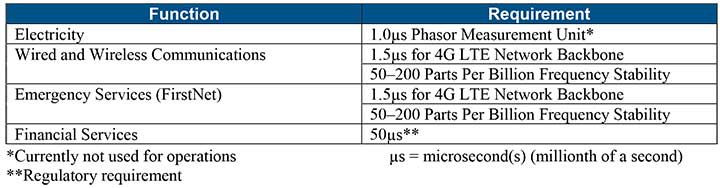
Table 1 shows timing requirements for critical infrastructure are, according to the report.
Table 1. (Image: DHS report)
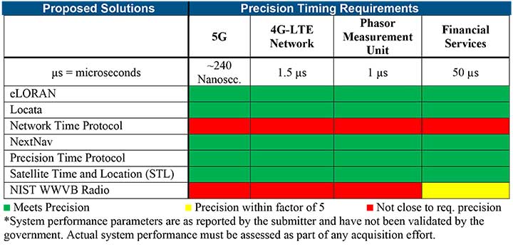
Table 2 from the report shows proposed timing solutions submitted by industry to DHS during a Request for Information (RFI) in December 2018. Systems that can meet or exceed timing requirements for critical infrastructure are indicated in green.
Table 2 (Image: DHS report)
Satelles responds
The Satelles company, which offers STL, issued a statement on the report. “This important report highlights the urgent need for GPS backup for critical applications, and it identifies and characterizes a variety of solutions that are available to meet this need today,” said Michael O’Connor, CEO of Satelles. “The report also describes the essential role of the federal government in urging industry to implement multiple technologies, without making the mistake of providing or selecting a single PNT solution.”
Continued O’Connor, “DHS goes on to define a baseline requirement for timing services accuracy for critical infrastructure. Not only does Satelles meet or exceed the precision timing specifications stated by DHS, but also our solution provides national coverage (including Alaska, Hawaii, and U.S. territories) and is commercially available now.”
The Geospatial Management Office (GMO) is the designated coordinator of geospatial activities throughout the core of the Department of Homeland Security headquarters and its component agencies.
Part I described how and why the GMO was formed and some of the early activities when resources were limited and expectations were low. Following the devastation along the Gulf States from Hurricane Katrina, the efforts to coordinate and empower the GMO gained focus and energy.
Image: USDHS
Needed: Better coordination
The magnitude of devastation caused by Hurricane Katrina, the uneven response and the inability for all levels of government to act in a unified manner prominently showed the gaping hole in the nation’s geospatial coordination mechanisms. The irony in this lack of coordinated government action, and the blame placed on President Bush’s administration, was that the lack of a geographic framework had been identified as a vulnerability since the late 1800s following the Civil War and never fully addressed.
A patchwork of Executive Orders and other stop-gap actions were in place, but action was needed by the Legislative Branch to finally address this, and, as is too often the case, it took a major disaster to cut through the politics and make this happen, resulting in the Geospatial Data Act. For a more in depth analysis of the Geospatial Data Act read the November 2018 Geospatial Solutions article “Geospatial Data Act Will Bring Huge Changes to America and the World.”
Hurricane Katrina had a sobering influence on federal agencies, providing renewed focus to find new ways to share information, and communicate openly and effectively using a common standard and language.
Dan Cotter, director of the GMO from 2005 through 2007, understood this challenge. Following his predecessor, Ryan Cast (the first director of the GMO), Cotter furthered the relationship with the Federal Geographic Data Committee (FGDC), establishing a Homeland Security Working Group with several sub-groups to advance DHS’s mission. Heavy lifting began on the symbol standards, data model and the U.S. National Grid (USNG).
This collaborative effort was furthered when the GMO secured funding for the first agency-wide enterprise license agreement (ELA) with Esri for GIS applications, training and services. The ELA reduced the cost and administrative difficulties surrounding procurement of GIS software. This dramatically increased the number of GIS practitioners seeking to partner with DHS, FEMA and the GMO.
Cotter was tapped to be the DHS chief technological officer in March 2007, passing leadership to Jeff Booth, who advanced the portfolio and led significant efforts to optimize the geospatial toolset of DHS while migrating it into the federal data-center environment.
Establishing a culture of trust does not come easy in bureaucracies, and this was no different for DHS. Being a relatively new agency, agility and eagerness were key traits, especially with a very fast-paced and high-stakes environment. People would volunteer to take on requested tasks, but that blurred the lines of responsibility.
The launch of GeoCONOPS
The HSE GeoCONOPS is a strategic roadmap to understand and improve the coordination of geospatial activities across the entire spectrum of the Nation. Updated on July 22, 2019, (Graphic: GeoPlatform.gov)
The FGDC and other working groups helped make introductions for the DHS GMO, which furthered the need to clarify each department’s role in the bigger geospatial picture. Defining these various operational roles and responsibilities led to the creation of the Geospatial Concept of Operations, or GeoCONOPS.
GeoCONOPS was a multi-year initiative, and is a playbook for a range of disaster-related events. Though initially limited to the disaster response and FEMA’s mission, GeoCONOPS was a structured community effort to clarify the types and timing of critical geospatial data and analysis needed in a disaster and continues to grow to address other DHS mission areas.
GeoCONOPS was initially published annually as a book, but changes were made too often and it is now only maintained as a website. GeoCONOPS describes the use of geospatial technology in the five mission areas of DHS:
Prevent
Protect
Mitigate
Respond
Recover
It also contains a curated inventory of geospatial resources available to the homeland security enterprise. The final version of the book (v.6, 2015) is available for download. Though often seen as a product, it is likely that the process behind the GeoCONOPS development was of equal or more value as it helped to define the lanes and build much-needed trust among the federal geospatial actors.
Cover of HSE GeoCONOPS resource book, v.4. (Image: Geoplatform.gov)
Through this effective collaboration model, the GMO benefitted from other significant advances elsewhere in the agency and the broader geospatial community. The development of the Homeland Security Information Network (HSIN) delivered value as a portal for the exchange of information and geospatial products on a common operating network among DHS member partners. If there is a major event taking place, such as political conventions, the Super Bowl, or the Boston Marathon, HSIN is sure to be part of the event’s command and control.
Its value was further proven by leveraging HSIN’s user-authentication capability, providing a trusted access-control mechanism for HSIN and other web-hosted geospatial capabilities. These access controls greatly reduced the deployment burden on the Geospatial Information Infrastructure (GII), which is an on-premises version of Esri’s ArcGIS Online suite.
The GII allows for trusted partners to gain access to hosted data, create working groups, and develop and share maps and geospatial applications. The GII also provides access to customized Common Operational Picture (COP) applications providing geospatial situational awareness for a number of operational partners.
These COPs are a result of their own evolutionary pathway, leveraging technology developed by and for the National Geospatial-Intelligence Agency (Palenterra) and through a first-generation viewer called the Infrastructure Critical Asset Viewer (iCAV). Now, with the tools in the GII, highly customized COPs and dashboards are developed for specific events and incidents and shared on an as-needed basis with the full range of stakeholders.
Where NGA and DHS intersect
DHS’s development of a national geospatial dataset put NGA and DHS on intersecting paths. The National Geospatial-Intelligence Agency (NGA) only focused on foreign threats and supporting the warfighter, but after the attacks of September 11, 2001, homeland defense was added to its mission.
NGA’s proven success internationally allowed it to quickly focus on acquiring and developing the best available sources of data. This conventional mission for NGA led to the formation of a new stakeholder group; hence, the creation of the Homeland Foundation Level Data (HIFLD) committee, which developed the first national dataset designed for homeland security and critical infrastructure protection, the Homeland Security Infrastructure Program (HSIP).
Having been initiated in the intelligence community, HSIP’s distribution was strictly limited, which inhibited its adoption across the mission space. To broaden its use, plans were developed to migrate all or much of the program to DHS and to shift the burden of restriction from the need-to-justify sharing to the need-to-justify restricting. With this new emphasis on sharing and openness, HSIP evolved to the current HIFLD Open and HIFLD Secure versions.
The GMO solidified its mission and purpose with the elements of community, transparency, security, technology and data falling into place. Through the leadership of the former GMO directors, the foundation they laid established the GMO as a respected and strong advocate throughout the agency and its partners, from local governments up to the federal level, becoming known as the Homeland Security Enterprise (HSE).
The HSE established a very real link extending from the on-scene first responder to the White House. By the time David Alexander, Ph.D., passed the baton to David Lilley in 2016, the GMO could deliver on its promises and was ready to expand outward. Lilley focused on realigning efforts to match DHS’s policy supporting National Special Security Events (NSSE) and community outreach through its network of 78 fusion centers.
Shortly after Lilley departed DHS, Hurricane Harvey’s torrential downpours and historic deluge began. Acting Director Michael Donnelly agreed to an innovative HIFLD solution to support FEMA operations to help mitigate the flood of data and requests that typically accompanies events of this magnitude.
Hurricane Harvey was Donnelly’s initiation. Following this and storms that followed, Donnelly focused on steadily maturing the GMO through deliberate outreach efforts and strengthening partnerships, building on outreach to regional fusion centers and non-traditional mission areas such as cybersecurity.
While not typically an operational player, the DHS Geospatial Management Office has become a trusted partner to those on the front lines, providing expertise, data, insights and architecture. The GMO is a foundational resource for operators, elevating their capabilities as a force multiplier.
While we can only hope against another cataclysmic natural disaster or major attack, when one does occur, the nation’s geospatial community is better prepared to respond to and recover from whatever comes.
As the saying goes, the better one strives to become, the greater becomes one’s enemies; so, as threats continue to evolve, our investments into geospatial technologies and critical infrastructure will pay dividends now and in the future helping to secure America’s safety here and abroad.
Remember, next time you are watching a large, national level sports game or a big storm approaching, know that others are watching, too. Behind the scenes another game is being played — one with much higher stakes. The players, you’ll not see, and the names, you’ll never know, but safety is their mission and GIS one of their primary tools.
Nate Smith — co-author and main contributor because of his work with the GMO — gave the following presentation to GeoDC, Washington, D.C.’s, geospatial community of interest on GeoCONOPS.
Epilogue
An inspiration for this article was to recognize the DHS GMO and its partners for their growth and utility as demonstrated during Hurricane Harvey, on the assumption that it was not otherwise acknowledged by the community. Well, awkwardly, in between this two-part drama, recognition did come from the Federal Geographic Data Committee in the form of the 2018 Doug D. Nebert National Spatial Data Infrastructure (NSDI) Champion of the Year Award.
Nate Smith has worked at the confluence of geospatial information and disaster management in both the domestic (U.S.) and international domains since 1992. He has been an innovator and pioneer in this discipline through his work supporting USAID’s Office of Foreign Disaster Assistance, FEMA’s GIS Solutions Branch and the DHS Geospatial Management Office.
He refined his knowledge of requirements through work as an emergency first responder and international humanitarian, and has shared his knowledge and experience through courses delivered at a number of Universities. His background includes deployments to disaster locations around the world in support of operations and coordination efforts for events ranging from insect infestation to conflicts.
He is currently an independent consultant affiliated with the Florida International University Extreme Events Institute and FIU’s Academy for International Disaster Preparedness. He earned a BA in Geography from UMBC and a Masters in Urban and Regional Planning from Virginia Tech.
Esri will be hosting the 21st annual Esri Federal GIS (FedGIS) Conference March 20-21 at the Walter E. Washington Center in Washington, D.C. All federal government agency workers are invited to join an anticipated audience of 3,000 attendees and share their experience in collaborating, innovating and connecting their work using spatial analytics technology.
Esri founder and president Jack Dangermond will discuss how location intelligence can be used to derive a deeper understanding of complex issues through data, as well as how it enables collaboration to develop innovative solutions for government.
He will be joined on the main stage by representatives from several leading organizations, including the following:
U.S. Department of Agriculture Animal and Plant Health Inspection Service (USDA APHIS) — “Protecting Plants and Animals to Feed Our Country and the World”
U.S. Department of Health & Human Services Office of Inspector General — “Fighting Fraud, Waste, and Abuse through Spatial Analytics”
American Red Cross — “Connecting and Helping Volunteers, Partners, and Citizens in Need”
On Wednesday, March 21, Dangermond will lead a thought-provoking conversation with the Honorable Susan M. Gordon, principal deputy director of National Intelligence at the Office of the Director of National Intelligence on the importance of connecting intelligence agencies through spatial analytics.
“It is always inspirational to attend this conference and hear how location intelligence has helped federal workers share information across agencies and connect to citizens,” said Jeff Peters, head of the national government sector at Esri. “Attendees will get a chance to hear directly from top government and technology leaders as they share their experiences collaborating, innovating, and connecting using spatial analytics.”
The conference is the site for announcements about the innovative use of Esri’s ArcGIS platform in federal, state and local government. The latest enhancements to ArcGIS and ArcGIS Pro, along with updates on desktop and enterprise mobile app environments, will be shared.
Other organizations will be providing use cases and best practices during workshops throughout the two days of the conference. Learn more at esri.com/events/federal.
U.S. Secretary of Transportation Elaine Chao has launched an initiative to safely test and validate advanced drone operations in partnership with state and local governments in select jurisdictions.
Prospective local government participants are asked to partner with the private sector to develop pilot proposals. After evaluating all of the applications, USDOT will invite a minimum of five partnerships.
The department also will publish a Federal Register Notice with more details about how applications will be evaluated and how the program will work.
More about the program is available on the DOT website.
The program will help tackle the most significant challenges in integrating drones into the national airspace while reducing risks to public safety and security, USDOT said. The program is designed to provide regulatory certainty and stability to local governments and communities, UAS owners and operators who are accepted into the program.
In less than a decade, the potential economic benefit of integrated unmanned aerial systems into the nation’s airspace is estimated to equal up to $82 billion and create up to 100,000 jobs, according to an economic report by the Association for Unmanned Vehicle Systems International (AUVSI).
The program will help the USDOT and Federal Aviation Administration (FAA) develop a regulatory framework to:
allow more complex low-altitude operations;
identify ways to balance local and national interests;
improve communications with local, state and tribal jurisdictions;
address security and privacy risks; and
accelerate the approval of operations that currently require special authorizations.
“This program supports the president’s commitment to foster technological innovation that will be a catalyst for ideas that have the potential to change our day-to-day lives,” Chao said. “Drones are proving to be especially valuable in emergency situations, including assessing damage from natural disasters such as the recent hurricanes and the wildfires in California.”
The pilot program will evaluate a variety of operational concepts, including night operations, flights over people, flights beyond the pilot’s line of sight, package delivery, detect-and-avoid technologies, counter-UAS security operations, and the reliability and security of data links between pilot and aircraft.
Industries that could see immediate opportunities from the program include commerce, photography, emergency management, precision agriculture and infrastructure inspections and monitoring.
“Stakeholders will have the opportunity through this program to demonstrate how their innovative technological and operational solutions can address complex unmanned aircraft integration challenges,” said FAA Administrator Michael Huerta. “At the same time, the program recognizes the importance of community participation in meaningful discussions about balancing local and national interests related to integrating unmanned aircraft.”
The White House has joined in to support continued growth of the emerging unmanned aerial vehicle (UAV) industry. Unmanned aircraft systems (UAS) technologies are powering a revolution in unmanned flight.
Already used by government, by research organizations, and by industry for more efficient and safe applications, drones are now becoming a developing part of the United States economy. A new initiative by the Office of Science and Technology Policy (OSTP) brought together 150 UAS community leaders for a recent workshop at the White House. The event was held to find out more about the UAS industry, where it’s headed, and to seek ideas for how government might contribute.
Given that the current administration has only limited time remaining, the group proposed some significant issues that could be launched, or at least where there should be focus. The only short-term goal that could be achieved by the end of the year is the release by the Federal Aviation Administration (FAA) of a Notice of Proposed Rulemaking for UAV operations over people.
One principle objective should be for the Federal Communications Commission (FCC) to develop rules in concert with industry for licensing allocated frequency spectrum. While the FAA has yet to develop rules for higher altitude, larger-UAV operations, the UAS industry requires spectrum for command and control of aircraft at high altitudes and for beyond visual line of sight operations. The FAA and FCC regulations should be developed in parallel.
The group felt another problem that should be tackled is UAS Traffic Management (UTM). While NASA has been investigating prototype UTM options and various industry leaders have been advocating a number of different approaches, the group seemed to indicate that unless government took some form of leadership role, a number of different, incompatible solutions might be developed.
Finally, there was discussion about how a number of states are implementing local UAS regulations, while the FAA believes it has responsibility for all U.S. airspace. However, large numbers of small UAS (sUAS) are expected to operate at lower altitudes, so local authorities believe they should assert more control, even though they were comfortable in the past ceding control of manned aviation to the FAA. However, nationwide, uniform safety regulations appear to be just as critical for UAS as for manned aircraft, which seems to imply that the FAA should lead the effort.
So, some good issues were identified that need serious work to enable UAS operations, but it’s always a problem when someone else gets stuck with the responsibility to find solutions — which will be the case when the administration changes. Hopefully the new guys will also believe how beneficial UAS will be for the economy and will chase down and help overcome these barriers.
Package Delivery
Meanwhile, on the package delivery front, Google’s Project Wing has been approved by FAA to begin testing, albeit within the confines of Northern Plains UAS test site in North Dakota. The heavier Google delivery drones will be tested from the ground up to 29,000 feet with external loads, and efforts will be made to fly them beyond line of sight without chase aircraft. Google will also prototype a low-altitude airspace management system for the tests that uses inexpensive comms and data technologies.
While authorization in the U.S. was still pending, Google went looking for somewhere to test its prototype drone delivery system, and in August 2014 undertook testing in Queensland, Australia. At that time Google was using a vertical take-off UAV system — they delivered portable radios and water bottles to farmers.
Google tests delivery drones in Australia.
Word is that Google is now looking at fixed-wing UAVs and cargo slung from them — maybe for transporting heavier packages.
Google’s new delivery drone?
And further North in Ontario, Canada, Drone Delivery Canada (DDC) is moving forward with the development and implementation of a commercial drone delivery platform for retailers, service organizations and government agencies. In remote parts of Canada, access to some communities can be difficult to impossible for conventional means. DDC expects to add additional sites later this year for beyond visual line of sight (BVLOS) testing, working with the Canadian government towards obtaining its operator status. DDC also just announced an agreement with a Canadian retailer to test and integrate its drone system with the retailer’s existing depot-to-depot delivery logistics.
DDC prototype drone delivery system.
And not to be left out of this picture, 7-Eleven has been working with drone manufacturer Flirtey to test autonomous delivery of convenience store items. Dispatched from a Nevada 7 Eleven store, two deliveries were completed to a local customer’s house using precision GPS, where the Flirtey drone hovered and gently lowered each package of goodies.
Flirtey drone delivers 7-Eleven goodies.
So, while the White House now seems to be actively engaged in supporting the introduction of UAS into commercial operations in the U.S., we still have many significant obstacles to overcome — not least are access to control frequencies, the development and introduction of drone traffic-control systems, and the coordination of federal and state rule-making. But this apparently has not deterred several organizations, including Google, DDC, Flirtey/7-Eleven, Amazon, Walmart and others, to trial drone package delivery. U.S. states have also recognized the promise of everything connected with UAVs and their operations, and are collaborating with the FAA to establish large swaths of the airspace for UAV testing.
What with the White House and states already on the UAV bandwagon, surely it won’t be long before we crack the nut and get significant commercial operations approved and underway.
Esri and Harris Corporation are embarking on a broad strategic relationship to develop modernized foundation GEOINT data production, apps and tools within a WebGIS environment, for federal agencies.
The partnership will advance the state-of-the-art in automated GEOINT (geointelligence) production methods leveraging commercial-off-the-shelf (COTS)-based solutions.
The collaborative effort will help programs across multiple security domains to meet the expected surge of commercial imagery from small satellites, unmanned aerial system (UAS) platforms and open-data sources.
Visit Esri and Harris Corporation at GEOINT Symposium 2016 this week: booth 828 Harris; Booth 600 Esri.
The late, great, oft-quoted Yogi Berra, in an interview shortly before his passing, was quoted as saying “I never said most of the things I said.” For our purposes, let’s concentrate on one of his most famous quotes: “When you come to a fork in the road, take it.”
On to GPS. I use the term GPS in a ubiquitous PNT (position, navigation and timing) sense for simplicity, because most people today use the term in a universal sense, similar to how we say “Google It” no matter which search engine we’re actually using.
Today, GPS is indeed at a crossroads, and there are multiple paths or avenues to follow — or Courses of Action (COA), as the government likes to say. Fortunately, most of you reading this fully realize GPS is so much more than just an atomic reference system in MEO, or Medium Earth Orbit. Let’s review the various GPS programs and see how they’re faring.
GPS III
Let’s be conventional and start with the hardware, the actual satellite bus (vehicle) being built by Lockheed Martin Space Systems in its Waterton facility in the beautiful foothills of the Rocky Mountains in Littleton just west of Denver, Colorado.
In an October 2015 speech before the International Astronautical Congress in Jerusalem, Israel, LMCO Chairman, President and CEO Marillyn Hewson stated the following in a marvelous speech entitled “There are No Borders in Space: International Cooperation Will Drive the New Space Age:”
“We must focus on three priorities for the future of space. The first is space as an instrument to create global industrial partnership. Second is space as a driver of economic growth. And third is space as an opportunity to inspire the next generation of innovators.”
Chairman Hewson concentrated on the future of space, as are we, and probably due to her venue, she naturally chose to focus on international cooperation. She went on to say this about GPS specifically:
“GPS III, the next-generation of the U.S. Air Force’s Global Positioning System, will share a new, common civil signal with other international navigation satellites like Galileo and GLONASS. That means people around the world will have more accurate and reliable positioning data and connectivity from a truly global positioning constellation.”
Speaking about space capabilities and opportunities in general, she said:
“Space-based technologies are ubiquitous today. Want to find an address? Find out the weather forecast? Talk to someone on the other side of the world? The fact is, space is already an enabler of economic growth. And with today’s innovations combined with the power of international partnerships, it has the potential to drive magnitudes more.
“Today, the space sector represents about 1 percent of global economic activity. Yet, I could argue that without space, the other 99 percent wouldn’t be nearly as effective or efficient. Partners are developing commercial satellites that connect people around the world, enable distance learning and fuel job growth in many sectors of the global economy.”
You really can’t fault any of Chairman Hewson’s statements about space and GPS in particular. Indeed, it is an excellent presentation as it embodies the essence of motherhood and apple pie for space-faring nations.
However, she has glossed over one of the most pressing problems, not only for GPS III, but for all potential U.S. space-based assets still to be launched: access to space. How are we going to actually lift the satellites into orbit? Where are the launch vehicles?
United Launch Alliance
ULA launch. (Courtesy of United Launch Alliance)
Many of you may have seen the latest GPS III launch services announcement by United Launch Alliance (ULA), a consortium of Boeing and LMCO launch companies taking advantage of the synergies each company brings to the launch arena. Officially, ULA is described as a 50-50 joint venture between Lockheed Martin and The Boeing Company, formed in 2006 to provide reliable, cost-efficient access to space for U.S. government missions.
Just a few weeks ago, ULA — the consortium that has launched all GPS satellites since 2006 with more than 90 consecutive government launches without a single failure, a world record — made what many consider to be a startling, albeit carefully worded, announcement regarding the latest and what many consider to be unduly restrictive government GPS III RFP (Request For Proposal) for launch services.
“ULA wants nothing more than to compete, but unfortunately we are unable to submit a compliant bid for GPS III-X launch services. The RFP requires ULA to certify that funds from other government contracts will not benefit the GPS III launch mission. ULA does not have the accounting systems in place to make that certification, and therefore cannot submit a compliant proposal.
“In addition, the RFP’s Lowest Price Technically Acceptable (LPTA) structure allows for no ability to differentiate between competitors on the basis of critical factors such as reliability, schedule certainty, technical capability and past performance.
“Further, under the restrictions imposed by the 2015 National Defense Authorization Act (NDAA), ULA does not currently have any Atlas engines available to bid and therefore is unable to submit a timely proposal.
“ULA remains fully committed to supporting America’s national security missions with world-class launch services. We look forward to working with the Air Force to address the obstacles to ULA’s participation in future launch competitions to enable a full and fair competition.”
A separate ULA press release states ULA will continue with development of its Vulcan launch vehicle, which they bill as a next-generation launch system. So it appears that it is merely the restrictions and caveats that pose a problem for ULA and GPS III launches, not technology or timelines.
“With the introduction of the Vulcan, ULA’s next-generation launch system (NGLS), ULA is transforming the future of space launch — making it more affordable, accessible and commercialized — and innovating to develop solutions to the nation’s most critical need: reliable access to space,” ULA said.
The Falcon .9 (Courtesy of SpaceX)
SpaceX
With ULA out of the picture, at least temporarily, for GPS III launches, this leaves the door open for Elon Musk, recently of Big Bang Theory fame, and his Space Exploration Technologies Corporation better known as SpaceX to step in and fill the void presumably with a variation of their heavy lift Falcon 9 rocket.
SpaceX promotes itself as the largest private producer of rocket engines worldwide, and no doubt that is true. SpaceX has demonstrated the capability for both successful launches and spectacular failures. That is almost to be expected for a new rocket engine and a new company, which only came about in 2002. However, where human lives are concerned, failure is not an acceptable option.
SpaceX is very much aware that a launch failure resulting in lives lost might well spell the end of SpaceX. With that as a given, SpaceX recently delivered its 100th Merlin 1D engine, nine of which form the basis for the first stage of the Falcon 9 launch vehicle. Indeed, SpaceX touts unparalleled redundancy — with nine Merlin 1D engines on the first stage, it could actually overcome a failure of any one of the Merlin engines and still have a successful launch.
Merlin ID engines all in a row. (Courtesy of SpaceX)
Only time will tell, however, and this scenario leaves the U.S. government with very few options as long as the current guidelines regarding the Russian RD-180 core are in place. Other companies such as Moog, Orbital Sciences, Aerojet Rocketdyne, Blue Origins and ATK, to name a few potential contenders, could separately or as a team bid on the next-generation launch vehicle for GPS III.
However, that would mean storing the GPS III satellites and payloads for inordinately long periods of time, which is both expensive and risky. Expensive in dollars, since each GPS III space vehicle (SV) would cost approximately $1 million per year — not an official figure, but a best guess from several sources, to store, and expensive and risky from an operational point of view in that the federal government and LMCO would have no idea if the GPS III SVs and payloads really worked as advertised.
They would have no idea if there were any major flaws or anomalies, and once the production line at LMCO space systems was shut down, it would be prohibitively expensive to restart, if that were even possible. Remember, three GPS III SVs are being constructed currently, and today there are only eight confirmed orders for GPS III SVs.
As for major anomalies, just think back to the GPS IIF launches where the first four each revealed a major and separate anomaly for IIF SVs that had to be corrected on all future SVs and payloads before further launches occurred.
My sources at LMCO in Littleton assure me the first GPS III SV with a complete payload, built by Harris nee Exelis, nee ITT, will be ready for delivery to the government in mid-2016, possibly earlier. With a 90-day checkout the first GPS III SV could be ready for launch as early as late fall 2016.
The problem at that point becomes — and actually is a problem right here and now — there is no evidence that the government currently has a viable certified program to launch, control or maintain the GPS III satellites and payloads. But that is another story with many twists and turns.
The Road Less Taken
Apparently, there are numerous options for the government where GPS programs are concerned, and for a change many of those options, while being considered outside the box, actually appear to be the smarter choice.
As that great American poet Robert Frost once famously wrote:
“I shall be telling this with a sigh
Somewhere ages and ages hence:
Two roads diverged in a wood, and I—
I took the one less traveled by,
And that has made all the difference.”
Until next time, Happy Holidays, Happy New Year and Happy Navigating on that road less traveled by.
UPDATE: Read news of the official announcement here.
The federal government is expected to announce today a new plan requiring anyone buying a drone to register the device with the U.S. Department of Transportation. The registration of the drone will enable authorities to track a drone back to its owner if used in a dangerous manner.
Under the plan, the DOT would work with the drone industry to set up a structure for registering the drones, and the regulations could be in place by Christmas.
The government has been concerned about the rise in close calls between unmanned drones and aircraft flying into and out of some of the nation’s biggest airports. In July, a passenger jet preparing to land at New York’s John F. Kennedy International Airport had a close call with a drone, which was 100 feet away from the jet at an altitude of 1,700 feet. Normal safe separation distance is between aircraft is at least 1,000 feet.
Private drones were also blamed for hampering aerial firefighting efforts over a California blaze in July. Firefighting aircraft trying to attack the fast-moving blaze in the Cajon Pass had to leave the area for around 20 minutes over safety concerns, officials said. That fire swept over a freeway and burned 20 vehicles.
On Oct. 6, the FAA announced the largest civil penalty proposed yet — $1.9 million — against a UAS operator for endangering the safety of the national airspace.
Brian Wynne, president & CEO of the Association for Unmanned Vehicle Systems International (AUVSI), released the following statement on today’s announcement that he is joining the U.S. Department of Transportation’s Task Force to develop a streamlined registration process for unmanned aircraft systems (UAS):
“AUVSI welcomes the opportunity to join this task force of government and industry stakeholders. This collaborative effort to develop an efficient process for UAS registration should lead to increased accountability across the entire aviation community.
“Under the FAA’s proposed small UAS rules released earlier this year, commercial operators would be required to register their platforms. Extending this requirement to other UAS users will help promote responsibility and safety.
“In addition to UAS registration, it is essential for the FAA to finalize its small UAS rules as quickly as possible. Once this happens, we will have an established framework for UAS operations, allowing anyone who follows the rules to fly. Considering that safety is at stake, time is of the essence to finalize the rules.
“Because safe operations are essential for all users of the national airspace, AUVSI is also looking forward to continuing its work with the FAA, the Academy of Model Aeronautics and more than two dozen supporters of the ‘Know Before You Fly’ campaign to educate newcomers to UAS technology about safe and responsible flying.”
Data is curated by SpecOut.com and sourced from the Center for the Study of the Drone at Bard College.
Avineon, Inc., a global provider of information technology, geospatial, and engineering support services, will distribute discount coupons for its new Metrics Extension to ArcGIS for Server at the 2015 Esri User Conference. Ten customers who activate the permanent Metrics Extension license with the coupon code will receive it for free. All others using the coupon will receive a 50 percent discount off the $4,995 price if the permanent license is activated by Aug. 31, 2015.
Avineon will be handing out the discount coupons in booth #1015 at the Esri User Conference being held July 20-23 at the San Diego Convention Center in California.In addition, Avineon will be holding a drawing each day for a Windows Tablet. Anyone who registers at Booth #1015 will be entered into the drawing, no purchase required.
The Metrics Extension enhances the value and usability of GIS data in ArcGIS by creating a spatial data warehouse in which key business intelligence metrics can be created and stored for historical reporting. It computes and stores key metrics such as asset quantity, length, or area coverage for a specified period. Storing this data permits important historical trends to be documented and evaluated for potential performance improvements and cost savings.
“Metrics Extension gives ArcGIS users better visibility into their enterprise geodatabase by revealing trends in their global and regional data sets,” said Joel Campbell, Avineon vice president of commercial systems. “The return on investment for Metrics Extension will be fast.”
Avineon developed the Metrics Extension for ArcGIS users across all markets, especially in applications where the installation, operation, and decommissioning of assets need to be tracked over time. Asset changes and trends can be tracked by timeframe and by geographic area, such as neighborhood, zip code, and political district. The most common applications will be in energy and water/waste water utilities, telecommunications, and local/state/federal governments.
Avineon will also showcase its entire portfolio of geospatial services and solutions available to the Esri community. As a long time Esri business partner, Avineon specializes in data centric services and solutions serving a variety of industries.
In the 2016 President’s Budget, submitted in February, the U.S. Air Force requested a budget of $122.2 billion. That exceeds the Office of Management and Budget’s recommendation by almost $10 billion. I applaud the Air Force action and think it may be too little, too late.
On the satellite or hardware side of the house, GPS III has problems centering on development and delivery issues with a subcontractor. In this case, however, the whole satellite program is not failing; just a component, albeit an important one: the Mission Data Unit or MDU.
For GPS III+, the Air Force plans for a two-phased competition process: a Production Readiness competition for up to three firm-fixed price contracts to mature competitors’ production designs for a competition in a full and open competition for up to 22 GPS III Production SVs [satellite vehicles] with an expected award in FY17/18.
This sounds great if you need an entirely new GPS III system, which consists of, at a minimum, a new payload, satellite, launcher and ground C2 system. OCX is only designed to work with current and planned GPS SVs, and it doesn’t even do that today. In fact, the government only needs an MDU, a critical part of the payload. Failure to produce the MDU on time has delayed GPS III by 18 months to date.
More troubling to me are the phrases from the government plan that essentially mean “We are going to pay competitors to mature their technology so they can compete against the current prime (LMCO), who is building the first 10 GPS III satellites.” The government is saying the competitors on their own cannot compete against LMCO so we, the government, are going to give them contracts and lots of money to help them get to a point where they can compete, and then we are going to have a recompetition.
This will to take at least three years and cost hundreds of millions of dollars, and LMCO may well win again in the end, but at least we will have conducted a competition. Does this make sense?
Will the U.S. Air Force initiate a competition to acquire an entirely new GPS III SV, or fix the problem with the current GPS III program, the MDU? It appears the Air Force is looking to pursue an entirely new GPS III system to include SVs.
A significant added cost to the GPS budget concerns the need for a new ground C2 system if the total new systems approach is taken. If preliminary elements of the GPS space segment are developed without cross-checking the impact to the GPS control segment, technical, operational, budgetary and schedule impacts will be significant.
The already troubled next-generation GPS ground control system, OCX, budget likely has not considered the integration costs of a newly developed, yet-to-be-procured GPS III+ SV. OCX today is geared for the GPS III already contracted for, and it is failing to meet that challenge in a spectacular and expensive way. It is possible, even probable, that OCX integration costs for yet another new model of GPS III family of satellites would increase the OCX budget significantly — unless one assumes that the Air Force acquires a perfectly matched new satellite that integrates seamlessly with OCX.What are the chances of that, and why would you spend hundreds of millions of scarce acquisition dollars to procure an exact and more expensive replica?
Budget constraints are tight and getting tighter, mandating the Air Force “do more with less” in every context. For GPS III SVs, this means developing an alternate MDU rather than buying a new block of GPS SVs.
The Coalition of Geospatial Organizations (COGO) has released its Report Card on the U.S. National Spatial Data Infrastructure (NSDI), and given the NSDI a C- grade. The NSDI aims to promote sharing of geospatial data throughout all levels of government, the private and non-profit sectors, and the academic community.
“Federal agencies have worked for many years to improve their geospatial programs, but the COGO member organizations believe that the national data sets and delivery systems (the NSDI) generally need improvement,” said Michael Vanhook, COGO chairman. “It is time for the federal government to more effectively engage the entire stakeholder community to ensure that America has the highest quality geospatial infrastructure. Doing so will allow us to more efficiently and effectively deal with society’s needs, and to reduce duplication of effort.”
The Executive Summary of the report calls out the need for greater data sharing between government and the private sector.
“The federal government jump-started many of the innovations and collaborations that create the current geospatial environment. However, as noted in the 2009 National Geospatial Advisory Committee (NGAC) report ‘The Changing Geospatial Landscape,’ the federal government is no longer the dominant data producer. Federal providers of geographic information cannot continue to think of themselves as players separate from the community of private sector, state, local, tribal, and other stakeholders…
“The relative shifts in data production from the federal government to the private sector and state and local government call for new forms of partnership. Furthermore, the hodgepodge of existing data sharing agreements are stifling productivity and are a serious impediment to use even in times of emergency. There is an urgent need to reexamine the relationships between data providers and users to establish a fair and equitable geospatial data marketplace that serves the full range of applications.”
According to the Executive Summary, “The Expert Panel concludes that the Framework requires attention, and that several actions need to take place.
The concept of the Framework needs to be reaffirmed.
A new model for Framework data needs to be adopted, and this new model must acknowledge the importance of local partners.
The Federal Geographic Data Committee (FGDC) needs to emphasize that the Framework is part of its Strategic Plan, and that it will work in collaboration with non-federal and non-governmental partners to build an effective NSDI Framework.”
As stated in the report’s foreword, COGO “recognizes the individual contributions of all federal, state, regional, tribal, and local government agencies that have worked in concert with the private and academic sectors to develop the National Spatial Data Infrastructure (NSDI) as it exists today. This work has spanned entire careers, and COGO applauds the sincerity of their efforts and the value of their contributions.”
COGO represents 170,000 individual geospatial practitioners. “Together, the coalition is delivering this assessment to help Congress, the administration, federal agency executives, and others understand the importance of geospatial data to the nation, as well as shortcomings of the NSDI,” COGO said in a statement.