Tag: field work

  • ComNav’s new T300 Plus GNSS receiver provides tilt compensation

    ComNav Technology has introduced the T300 Plus GNSS receiver, an upgrade to its T300 receiver.

    Designed for demanding surveying tasks, the rugged T300 Plus GNSS features full-constellation tracking capability, tilt compensation, 4G/Wi-Fi connection, 8-GB internal memory and an easy survey workflow with Android-based Survey Master Software. It is designed to make collecting accurate data easy and fast, whether done by a beginner or experienced professional surveyor.

    As an upgrade of the T300, SinoGNSS T300 Plus combines a GNSS board, Bluetooth and adjustable TX/RX UHF, Wi-Fi and 4G modem into one rugged device. Its built-in 4G modem ensures the T300 Plus works with all kinds of CORS worldwide. Moreover, T300 Plus built-in tilt sensor supports maximum 30-degree pole tilt and keeps the compensation accuracy within 3 centimeters, and the user can check the electronic bubble on the controller for fast surveys in the field.

    With two hot-swappable batteries, the T300 Plus helps to extend working hours, the company said. The battery LEDs flash when the battery runs low; they can be replaced or charged directly while in the T300 Plus through an external power connection. Its consumer-grade battery design is compatible with the Canon LP-E6, which can be purchased in retail stores.

    https://youtu.be/HddhJXF8D3Y

    ComNav Technology also provides the T300 Plus GNSS surveying system with the Android-based R500 data collector and Survey Master software, providing for powerful and straightforward survey workflow in the field.

    The T300 Plus is now available through ComNav Technology authorized local distributors or directly through ComNav Technology.

  • Trimble Penmap for Android designed for field surveying

    Trimble has introduced Penmap for Android, a cloud-connected application for field surveying and high-accuracy geographic information system (GIS) data collection that works on mobile handhelds, smartphones and tablets.

    Trimble Penmap for Android focuses on core survey and mapping tasks such as cadastral and boundary surveys, as well as establishing local control, stake-outs, quality checks and asset management for utilities. It provides both professional surveyors and field workers with an intuitive, easy-to-use map-based interface to manage features and attributes for high-accuracy GIS and complete survey documentation.

    The application is also ideal for use in the energy distribution industry for locating infrastructure and recording critical information on encroachments, clearways and existing monuments, the company said.

    The application runs on a variety of Android devices, including the rugged Trimble TDC100 handheld, and supports full-featured Trimble GNSS receivers such as the Trimble R10, R8s and R2 receivers.

    Trimble Penmap for Android is optimized to integrate with the new Trimble Catalyst service, a software-defined GNSS receiver that connects to the small, inexpensive plug-and-play DA1 antenna, and allows surveyors to choose an accuracy level from meter to centimeters to suit their application needs.

    Together, Penmap and Trimble Catalyst — both purchased through a fixed monthly subscription — offer an on-demand, lightweight and low-cost professional surveying system that provides value, convenience and flexibility, the company added.

    “The addition of Penmap expands our portfolio to address the needs of organizations that require a value-packed, flexible survey system,” said Matt Delano, general manager of Trimble’s Land Administration solutions. “Surveyors using the Penmap application with Trimble Catalyst can easily manage seasonal shifts in survey activity by scaling up or down without a capital investment. Survey managers will find it an efficient way to carry out field checks without tying up expensive equipment used by their field crews. They can simply use a phone, the Penmap application, a Catalyst subscription and the DA1 antenna.”

    Trimble Penmap for Android includes the Penmap Project Manager, which is used to set up projects, create templates and add team members.

    Penmap Project Manager works with the Trimble Connect platform for storing and transferring data between the field and office.

    Trimble Connect, which is also included in the Penmap subscription, is a collaborative cloud-based platform that enables organizations to set up and deploy projects to their field users. Information collected in the field is synced back to the office in real-time where it is stored, managed and communicated to team members.

    Data can also be exported from Penmap Project Manager into back-office systems in a variety of file formats for viewing and sharing.

  • JAVAD GNSS Remote Assistance and Monitoring Services

    JAVAD GNSS Remote Assistance and Monitoring Services

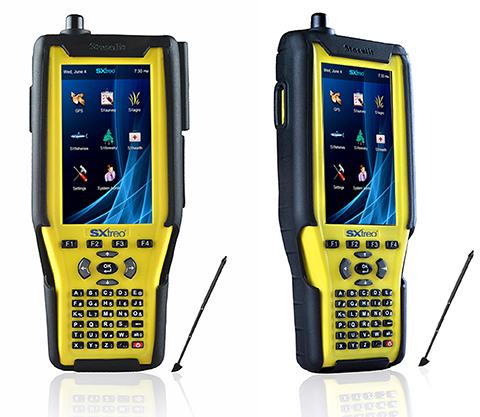
    Together with free live technical support provided by practicing professional land surveyors via phone, email, message board and text messaging, JAVAD GNSS is pleased to announce the release of another innovative product, RAMS, Remote Assistance and Monitoring Services for J-Field software. J-Field is the field controller software developed for the TRIUMPH-LS GNSS receiver and the VICTOR-LS field controller. RAMS is currently available to all users of J-Field, JAVAD’s powerhouse software for survey data collection, stakeout, and computations.

    Photo: JAVAD GNSS
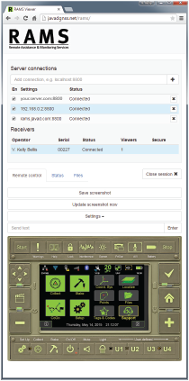
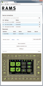
With the J-Field enabled receiver/controller connected to the Internet (via internal GSM SIM card, Wi-Fi hotspot or Ethernet), users can make their receiver/controller accessible to JAVAD’s customer support team from anywhere in the world with three button presses. “It’s like having the support person looking over the user’s shoulder,” said Shawn Billings, a surveyor from Texas.

    While the TRIUMPH-LS is connected to RAMS, the user and support person share control of the receiver, giving the support person the ability to make changes to settings on the receiver or train the user remotely. “It has changed the way support is conducted, making us more efficient at determining issues and more effective in training users,” said Billings. The connection is password-protected to ensure that only those intended have remote access to the receiver.

    Beyond technical support, RAMS server access is available to the user community as well. This offers the ability for project managers to remotely supervise crew efforts in the field. Because operational control of the TRIUMPH-LS/VICTOR-LS is shared between the server user and the field user, the server user (project manager) could perform the more complex operations of land surveying, such as COGO calculations and localizations, as necessary, and then allow the field user (crew member) to continue the more routine tasks of data collection.

    Photo: JAVAD GNSSShould the task be simpler to accomplish with office software, RAMS allows file transfer directly from the LS to the server user’s own computer and vice versa, thus enabling the project manager to easily export points, linework (dwg, dxf, shape), vectors, photos and other project-related data from the LS to his desktop. From there, he can manipulate the data in his desktop application and then copy files, with newly computed coordinates or linework, back to the LS for the crew to work with in the field. In this way, RAMS uniquely supports the obligation surveyors have to exert responsible charge over their field crews.

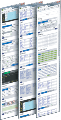
    The full receiver control, the access to receiver files, the robust RTK features of the TRIUMPH-LS and the fully customizable collection settings in J-Field make site monitoring possible as well.

    RAMS server can be accessed with almost any device with an Internet browser and Internet access. “I’ve used RAMS server to assist customers from my desktop computer, laptop, android tablet and even my cell phone,” Billings added. “Using JAVAD’s RAMS server requires no installation of software on the remote device, only an Internet connection and web browser.”

    For those wanting to operate RAMS on their own server, the RAMS Server application is available from JAVAD GNSS. An Android version of RAMS Server is also available, allowing users to connect an Android device directly to the TRIUMPH-LS without the need for an Internet connection. RAMS for Android creates a local network between the Android device and the LS and allows a field user to see and manipulate J-Field with the Android device should it be necessary to work with the LS beyond the reach or view of the user.

    For more information on RAMS, J-Field, TRIUMPH-LS, VICTOR-LS and other JAVAD GNSS solutions, visit www.javad.com, email [email protected] or call 408-770-1770.
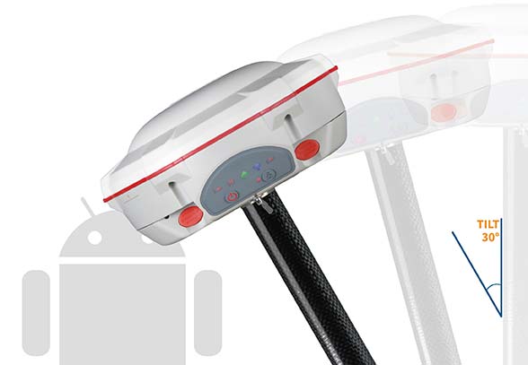
     

  • $100 for 300 Well-Chosen Surveyor Words

    If you are a professional land surveyor, we’d like to hear from you! Send us a brief account of how you use GNSS in your surveying work, what tips and tricks you can share with other surveyors, and what other hardware and software you are combining with GNSS to get the job done.

    Submit around 300 words, although you can certainly go longer if you wish. Five winners will be chosen from the submissions received at [email protected]; winners will be chosen on the basis of clarity, liveliness, and, in some small measure, the unusual nature of the surveying tasks you perform or the way you go about them. Winners will receive $100 gift cards.

    But we’re interested in hearing about straight run-of-the-mill jobs, too! Send your entries to [email protected]. Some entries may also be chosen for further development into articles for this newsletter, or GPS World magazine, or other publishing opportunities.

  • Cedar Tree Handhelds Now Under Juniper Systems

    CT4-Handheld-W
    The CT4 and other rugged handhelds by Cedar Tree Technologies will now be available through Juniper Systems.

    Juniper Systems is merging its subsidiary company, Cedar Tree Technologies, into Juniper Systems. The move will allow customers to purchase Cedar’s Android-operated rugged handhelds directly from Juniper Systems.

    Juniper Systems launched Cedar Tree Technologies as a rugged handheld company in August 2014.

    “With a reputation for top-of-the-line, ultra-rugged handheld computers, Juniper Systems aimed to expand its products to meet the needs of customers who may not need the outstanding level of ruggedness or support that Juniper handhelds provide. And that’s how Cedar Tree Technologies began. Cedar handhelds lie somewhere between consumer devices and Juniper Systems’ ultra-rugged handhelds, providing a mesh of both ruggedness and affordability,” said a statement from the company.

    Cedar handhelds run on the Android operating system, offering access to thousands of business-ready apps and Google services via the Google Play Store. This provides users with an off-the-shelf product, eliminating the need to download third-party data collection software. Juniper Systems has published a blog post that outlines the differences between Cedar and Juniper handhelds.

    The Cedar product line that Juniper Systems will now be carrying includes three new handheld devices:

    • CT7 Rugged Tablet. Featuring a large, 7-inch display, the CT7 tablet is IP67 waterproof and dustproof, and is priced at $899 USD.
    • CT4 Rugged Handheld. The CT4 handheld is a more compact device than the CT7. Featuring a 4.3-inch display and an IP68 waterproof and dustproof rating, it is priced at $489.
    • CMP1 Miniphone. The CMP1 Miniphone is rated IP65 (dustproof and resistant to water), and is ideal for swapping out a regular smartphone for outdoor excursions, for kids, or for use as an emergency phone. The CMP1 sells for $124.

    To learn more about Juniper Systems’ new Cedar handhelds, visit the company website.

  • Juniper Systems Pulls Cedar Tree Under Its Banner

    Juniper Systems Pulls Cedar Tree Under Its Banner

    CT4-Handheld-W
    The CT4 and other rugged handhelds by Cedar Tree Technologies will now be available through Juniper Systems.

    Juniper Systems is merging its subsidiary company, Cedar Tree Technologies, into Juniper Systems. The move will allow customers to purchase Cedar’s Android-operated rugged handhelds directly from Juniper Systems.

    Juniper Systems launched Cedar Tree Technologies as a rugged handheld company in August 2014.

    “With a reputation for top-of-the-line, ultra-rugged handheld computers, Juniper Systems aimed to expand its products to meet the needs of customers who may not need the outstanding level of ruggedness or support that Juniper handhelds provide. And that’s how Cedar Tree Technologies began. Cedar handhelds lie somewhere between consumer devices and Juniper Systems’ ultra-rugged handhelds, providing a mesh of both ruggedness and affordability,” said a statement from the company.

    Cedar handhelds run on the Android operating system, offering access to thousands of business-ready apps and Google services via the Google Play Store. This provides users with an off-the-shelf product, eliminating the need to download third-party data collection software. Juniper Systems has published a blog post that outlines the differences between Cedar and Juniper handhelds.

    The Cedar product line that Juniper Systems will now be carrying includes three new handheld devices:

    • CT7 Rugged Tablet. Featuring a large, 7-inch display, the CT7 tablet is IP67 waterproof and dustproof, and is priced at $899 USD.
    • CT4 Rugged Handheld. The CT4 handheld is a more compact device than the CT7. Featuring a 4.3-inch display and an IP68 waterproof and dustproof rating, it is priced at $489.
    • CMP1 Miniphone. The CMP1 Miniphone is rated IP65 (dustproof and resistant to water), and is ideal for swapping out a regular smartphone for outdoor excursions, for kids, or for use as an emergency phone. The CMP1 sells for $124.

    To learn more about Juniper Systems’ new Cedar handhelds, visit the company website.

  • Fleetmatics Enhances Field Service Management with New Features

    Fleetmatics Group now offers new features for its mobile field service management solution Fleetmatics WORK. The enhancements help businesses to operate more efficiently and maximize their resources, the company said. Fleetmatics is a global provider of mobile workforce solutions for service-based businesses.

    This latest release dramatically accelerates time to cash for SMB operators by embedding a payment link directly into the emailed invoice that is generated. With this new online payment powered by Stripe, Fleetmatics WORK closes the loop between job completion and payment. Jobs can now be invoiced from the field instantly via email and transactions can be processed securely in real time.

    Fleetmatics WORK has added integrations with QuickBooks Online in the U.S. and MYOB AccountRight Live in Australia and New Zealand. Now, when jobs are completed, the invoices flow seamlessly from Fleetmatics WORK to the user’s accounting system and updated client information is sent between the systems to keep all data in sync, Fleetmatics said.

    Business owners now have additional tools to manage fieldworkers. As service businesses grow, it becomes increasingly important for them to have manageable views of their field. New fieldworker tags in Fleetmatics WORK give dispatchers clear visibility to sort schedules and make assignments based on best fit.

    “Our mission is to help customers achieve greater levels of productivity, service and efficiency,” said Jonathan Durkee, Vice President of Product Management for Fleetmatics. “With the new online payments, seamless accounting integrations and increased fieldworker visibility we’re enabling field service businesses to drive even stronger results.”

    Free training and ongoing support is available to all users through Fleetmatics’ award-winning customer service, which provides education and best practices for transforming data into actionable business intelligence.

  • CartoPac 5.0 Optimized for Windows 8 to Manage Data in the Field

    CartoPac International Inc. has announced a major new release of the CartoPac Mobile Platform. CartoPac 5.0 extends the mobile platform with support for Windows 8 and introduces the CartoPac Workflow Manager, which provides a structured process to manage the use of geospatial data across the enterprise.

    CartoPac will demonstrate the applications and technologies of Version 5.0 in the free CartoPac Mobility Webinar Series beginning on September 30.

    The CartoPac Platform is a configurable suite of field and office tools designed to maximize the productivity of crews as they digitally map, inventory and inspect critical assets using GPS-enabled mobile devices. Seamlessly integrating with the Esri ArcGIS Server, CartoPac is used extensively by oil and gas companies, pipeline operators, electric utilities, state/local governments and environmental engineering firms to populate the enterprise GIS and asset-management systems with captured infrastructure information.

    The new CartoPac Workflow Manager (CWM) in CartoPac 5.0 provides organizations with a structured workflow to view, edit, validate and approve asset data as it moves from the field back into the enterprise. CWM ensures that individuals responsible for data are notified as it comes into the organization so they can incorporate the data into systems related to work-order fulfillment, risk analysis, integrity modeling and other asset management processes.

    CartoPac developed CWM for the management of heavily regulated assets in the field, such as gas pipelines and electric distribution infrastructure. A module within the CartoPac Server, the CWM extension creates an audit trail of all the edits and modifications made to the data sets that represent the monitoring and maintenance of real world assets in the field.

    “CartoPac Workflow Manager fills the gap between data collection and enterprise asset management systems to enable organizations to maximize the value of their data,” said CartoPac CIO Scott Crouch. “CWM enables organizations to show regulators they have a structured process for tracking and responding to the conditions of their critical assets and has proven to be key component for assisting companies with their regulatory compliance and integrity management programs.”

    Further expanding the capabilities of the CartoPac mobile components, version 5.0 has been optimized for the Windows 8 operating system running on standard GPS-enabled laptop computers and tablet devices. This migration means that crews can use CartoPac to collect and manage asset data in the field on the same hardware devices they will use back in the office to run their daily business applications.

    “The attractive cost, integration with GPS and expanded performance of Windows 8 tablets and laptops will enable organizations to put more personnel into the field, ensuring that vital infrastructure is mapped, inventoried and properly managed,” said Crouch “Laptop/tablet-equipped maintenance personnel in the field will now be able to run CartoPac solutions on the hardware they already use for tracking repairs and closing work orders.”

    To demonstrate the advantages of enterprise asset management, CartoPac has launched the CartoPac Mobility Webinar Series, which will feature applications by electric and gas utilities and highlight new mobile technologies. The first webinar, “Applying New Mobile Technologies to Electric Utility Inspections,” will be presented with EDM International Inc., a Colorado electric utility services company.

    The free “Applying New Mobile Technologies to Electric Utility Inspections” webinar will be held on September 30, 2014, at 4:00 pm Eastern Time. To register, click here.

  • Rugged IP68 GPS Handhelds and Field Computers Launched

    Rugged IP68 GPS Handhelds and Field Computers Launched

    The GAGAN-enabled Sxtreo GN11.
    The GAGAN-enabled SXtreo GN11.

    Stesalit today announced the availability of the SXtreo range of rugged GPS handhelds for survey, industrial use, and field work under extreme conditions such as agriculture, forestry, roads, security and construction.

    The SXtreo series of mobile devices are rated IP-68, meaning they are waterproof, dust proof, shockproof, and are coupled with built-in mobile GIS applications. Long battery life allows GPS data collection for a full work day, without the need for recharging. The GNSS devices come with full-size USB port for connecting devices.

    Stesalit is based in India, and the SXtreo gives that country an affordable option to take geotagged photos and conduct waypoint surveys. The design and conceptualization of SXtreo is a result of the in-house R&D effort of Stesalit. The road towards the birth of SXtreo is presented in the video:

    The GAGAN-enabled SXtreo GN series of rugged GNSS field computers and PDAs comes with a full keypad and large five-inch sunlight-readable screen for field data entry in large forms. These models are designed for GPS data collection and asset management, socioeconomic surveys, mapping, agriculture, logistics, forestry, public transportation, construction and security.

    The SXtreo WP 60 and WP61 devices have all the features of a smartphone.

    The Sxtreo WP 61 rugged smartphone.
    The SXtreo WP 61 rugged smartphone.

    SXtreo handheld’s Android and embedded Linux-based open-source secured operating systems are compatible with a range of sector-specific applications designed by Stesalit.

    • SXgeo is specially designed for waypoint, routes, and track surveys. The added advantage from the similar existing applications is that one can capture geotagged photos and transfer the survey data through GPRS.
    • SXsurvey is a complete suite for comprehensive survey management. With the features of SXgeo, one can also create large forms dynamically in the devices for survey data collection.
    • SXfield is specifically built for the field workers and employees working away from office like road construction, oil, gas and other utility services, logistics and distribution chains, FMCG, consumer and white good companies with large sales networks, operations and maintenance organizations with large service networks, and security organizations including police.
    • The integrated application SXagro is a geospatial agriculture decision-support system in use by agriculture universities and state agriculture departments.

    In addition, the SXtreo range of IP68 rugged smartphones is compatible with most of the off-the-shelf mobile software applications.

  • Topcon Introduces Field Controller for Advanced Data Collection

    Topcon Positioning Group announces a new data controller — the FC-500 — with numerous features and benefits, including a large 4.3-inch touchscreen display and 5MP camera with built-in LED flash.

    The FC-500 is designed for the professional operating Topcon MAGNET Field, Site and Layout software and Topcon’s Pocket 3D.

    Ray Kerwin, director of global surveying products, said, “The FC-500 works with all Topcon GPS/GNSS receivers and total stations, and meets or exceeds all field application requirements.  Additionally, the FC-500 works with the new Topcon LN-100 instrument dedicated to BIM and one-person construction layout, simplifying workflow with the seamless integration with our MAGNET suite of software solutions.”

    Kerwin said, “With a sunlight readable screen, the controller is easy to use even in bright sunlight.  It is the ideal job site controller in any condition (waterproof up to one meter, IP68 rating) and the large camera format with built-in LED flash and built-in 8GB flash storage allows the storing of hundreds of job site photos.”

    The standard model has both Bluetooth and Wi-Fi connectivity, while the FC-500 GEO has Bluetooth, WiFi and GPS.  A third model comes with the addition of a 3.5G cellular modem that allows access to the MAGNET Enterprise Solutions suite, “making the FC-500 the perfect field instrument for sending and receiving data files to the MAGNET cloud,” Kerwin said.

    For the GIS professional using MAGNET Field software, the FC-500 has a geotagging feature that allows imprinting file information, including GPS location, directly on photos.

  • Juniper Systems’ Archer Field PC Records Elevation of Remote Himalayan Peak

    Juniper Systems’ Archer Field PC Records Elevation of Remote Himalayan Peak

    Juniper_Archer_on_Mountain
    Photo credit: Mark Fisher at www.fishercreative.com, Instagram: @fishercreative; via Juniper.

    Juniper Systems’ Archer Field PC has beenused to record the elevation of a never-before-climbed peak in the remote Myanmar Himalaya. The peak, Mount Gamlang Razi, has historically been known as the second highest peak in Southeast Asia, but a joint American-Myanmar-led expedition set out on a mission last September to hopefully prove that it is in fact the tallest. Read the whole story on Juniper Systems’ blog.

    Standing at a reported 5,881 meters tall, Mount Hkakabo Razi has long been known as Southeast Asia’s highest peak. In recent years, however, the legitimacy of the elevation of Hkakabo Razi has come into question. Current digital analysis suggests that initial surveys of Mount Hkakabo Razi were overstated and its actual elevation is as much as 100 meters lower than originally believed. At the same time, digital analysis suggests that virgin-peak Gamlang Razi may in fact be the taller peak. This controversy prompted Idaho resident and experienced climber Andy Tyson to lead an American-Myanmar expedition team on a three-week approach through 150 miles of cobra-riddled, mosquito-infested jungle, and from there up to the peak of Gamlang Razi to measure its elevation in person.

    Tyson needed a device that could accurately record the elevation at the summit, while being able to withstand the extreme conditions of the hot, wet jungle and the frozen mountaintop. With this in mind, Tyson requested from Juniper Systems a top-of-the-line rugged handheld. In response, Juniper Systems provided the team with an Archer Field PC with Hemisphere GPS XF101 receiver, along with training to record the GPS data they needed.

    Setting up the Archer Field PC to collect GPS data. Photo credit: Mark Fisher at http://www.fishercreative.com. Instagram: @fishercreative
    Setting up the Archer Field PC to collect GPS data. Photo credit: Mark Fisher at http://www.fishercreative.com/Instagram: @fishercreative/via Juniper.

    After a 35-day journey, Tyson and the team successfully summited Gamlang Razi, with the Archer Field PC in hand. After collecting GPS data at the top, the data was sent via satellite phone to Juniper Systems for analysis. After post-processing the data against terrestrial base stations in Lhasa, Tibet, and confirming the results with Effigis in Montreal, Canada, Juniper Systems concluded that the elevation of Gamlang Razi was 5,870 meters, ±2 meters. This suggests that Gamlang Razi is taller than nearby Hkakabo Razi by approximately 112 meters and should be considered Southeast Asia’s new highest peak.

    However, there are many — particularly natives to Myanmar — who are not ready to accept changes to Hkakabo Razi’s original elevation measurement. This was made apparent in a letter Myanmar’s president, Thein Sein, wrote to Tyson and the team after their successful summit, congratulating them for summiting Southeast Asia’s second-tallest peak.

    Tyson remains firm in his assertion that Gamlang Razi is the country’s highest peak, but some have suggested that the debate may not be over until someone actually climbs Hkakabo Razi and measures it in person. Juniper Systems said they have a handheld for the job, should that time come.

    The expedition team. Photo credit: Mark Fisher at http://www.fishercreative.com. Instagram: @fishercreative
    The expedition team. Photo credit: Mark Fisher at http://www.fishercreative.com. Instagram: @fishercreative/via Juniper.
  • GE and ikeGPS Offer Mobile MapSight Device for Utility Workers

    GE and ikeGPS Offer Mobile MapSight Device for Utility Workers

    GE MapSight combines GPS, laser rangefinder, digital camera, and a digital compass into an all­-in-one field data collection device.
    GE MapSight combines GPS, laser rangefinder, digital camera, and a digital compass into an all­-in-one field data collection device.

    GE’s Digital Energy business is branding ikeGPS’ field measurement product as MapSight. The product integrates laser, camera and GPS technologies, enabling utilities to quickly and accurately collect measurement and location data on any of their joint-use utility poles or field assets, ikeGPS said in a statement announcing the partnership.

    The MapSight solution addresses many complexities of field data collection, the company said. It dramatically reduces the time required and cost incurred to collect joint-use pole data such as wire heights, widths, clearances, attachment points, diameters and span heights. The MapSight solution — which provides front-end remote measurement and data collection for utility assets — works seamlessly with GE’s SmallWorld Electric Office to provide an end-to-end data collection solution for utility workers. Once collected, the MapSight device can feed data directly into GE’s FieldSmart mobile applications and SmallWorld technology suite. Using the device, utility workers can greatly improve field data collection efficiency, typically reducing the time required to collect utility asset data by more than 50 percent, ikeGPS said.

    The MapSight handheld.
    The MapSight handheld.

    “ikeGPS is proud to announce that our solutions to the electric utilities segment have been integrated with GE’s software and branded as MapSight,” said Glenn Milnes, CEO, ikeGPS. “This agreement further validates the one-of-a-kind measurement capabilities that our solution offers GE and its utility customers.”

    MapSight enables field utility workers to remotely capture the location of their utility assets and every necessary measurement from a single photograph. This ability enables utility workers to measure the height of a span, the height of an object when the base is not visible and the distance between any two poles or points in the field and in real time. The geo-located photo provided by MapSight allows for further measurements to also be performed in the field. Another advantage of MapSight is that the unit provides field workers with consistent data, taking the guesswork out of measuring utility poles and assets. With the unit’s ability to geo-locate and time stamp photos, utility workers can easily verify when and where a measurement was made.

    “Together, GE and ikeGPS have created an end-to-end solution set for field utility data collection and analyzation,” said Bryan Friehauf, product line leader–software solutions, GE’s Digital Energy business. “Previously, data had to be collected manually using analog tools such as hot sticks, measuring wheels and a pen and paper. Our MapSight device streamlines the data collection and analyzation processes for field utility workers by enabling the collection of joint-use utility pole data quickly, digitally and remotely on a single, easy-to-use platform.”