Tag: fire damage

  • The world is on fire: Wildfires rage in Greece

    The world is on fire: Wildfires rage in Greece

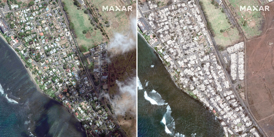
    One month after fire blazed through the Greek island of Rhodes in July 2023, more fires have ripped through Greece amid a heatwave in southern Europe, reported the European Space Agency (ESA).

    A Copernicus Sentinel-2 image (Figure 1) shows the ongoing blaze near Alexandroupoli in the Evros region of northeast Greece – close to the Türkiye border.

    The satellite image is a blend between a natural color and a shortwave infrared composite to highlight the fire front, which was approximately 70 km long as of August 23. The fire has produced a plume of smoke that stretched 1,600 km southwest towards Tunisia. Burned areas can be seen in the image in dark brown.

    Figure 1. (Image: ESA)
    Figure 1. (Image: ESA)

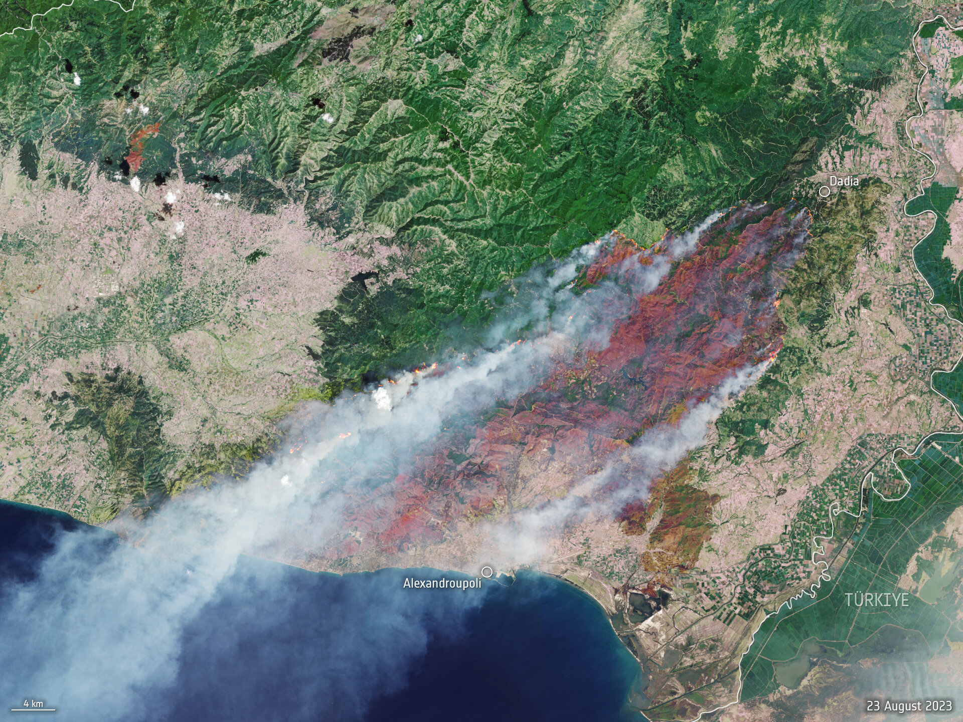
    The Copernicus Sentinel-2 mission is based on a constellation of two identical satellites, each carrying a wide swath high-resolution multispectral imager with 13 spectral bands for monitoring changes in the Earth’s land and vegetation.

    In response to the fires, the Copernicus Emergency Mapping Service has been activated in North Attica, Rodopi, Euboea Island, the Sterea Ellada Region, and East Macedonia. The service uses satellite observations to help civil protection authorities and the international humanitarian community respond efficiently to emergencies.

    Greece has experienced daily outbreaks of dozens of fires over the past week as gale-force winds and hot, dry summer conditions combined to whip up flames and hamper firefighting efforts. On August 26, firefighters tackled 122 fires, including 75 that broke out in the 24 hours between August 25 and August 26, the fire department (formally the Hellenic Fire Service) said.

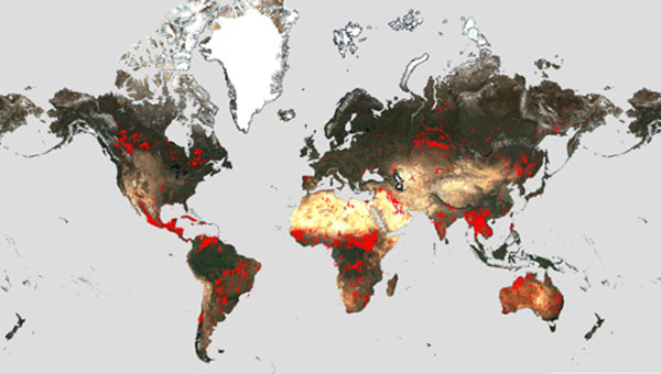
    Scientists have warned that climate change and land-use changes are projected to make wildfires more frequent and intense. In response, the ESA has reopened its World Fire Atlas, which provides a detailed analysis and map of wildfires across the globe.

    The causes of Greece’s two largest fires have not yet been determined. For some of the smaller blazes, officials have said arson or negligence is suspected, and several people have been arrested, reported NBC News.

  • The world is on fire: Fire strikes Maui

    The world is on fire: Fire strikes Maui

    Satellite images taken on June 25 and August 9 show an overview of southern Lahaina, Hawaii, before and after the recent wildfires. (Image: Maxar Technologies)
    Satellite images taken on June 25 and August 9 show an overview of southern Lahaina, Hawaii, before and after the recent wildfires. (Image: Maxar Technologies)

    The number of wildfires this year only increases as the island of Maui, Hawaii has been struck by several wind-whipped wildfires fueled by Hurricane Dora. Flames engulfed parts of Hawaii the morning of Wednesday, August 9, destroying a centuries-old town and killing at least 90 people, reported NBC News.

    The fires took people on the island by surprise on Tuesday, as it left behind burned-out cars on once busy streets and smoking piles of debris where historic buildings once stood. Residents and tourists were forced to evacuate the area – including some who reportedly jumped into the ocean to escape the flames.

    The National Weather Service believes the combination of high winds and low humidity is what caused the dangerous fire conditions across the island.

    On Wednesday, a series of maps from NASA’s Fire Information for Resource Management System were released, highlighting the number of wildfires still burning on the island.

    Satellite images also were taken, showing hundreds of shops and homes burned to the ground. The satellite images focus on the historic Lahaina area, which dates to the 1700s and has long been a popular tourist destination rich with native Hawaiian culture.

    In one image from Maxar Technologies, the historic area of Banyan Court in Lahaina appears to have been mostly reduced to ash. Some 271 structures were damaged or destroyed, the Honolulu Star-Advertiser reported, citing official reports from flyovers conducted by the U.S. Civil Air Patrol and the Maui Fire Department.

    The fires in Maui come after scientists have warned that wildfires are becoming more frequent and more widespread across the globe.

    Rising global temperatures and the increased extreme weather has led to a surge in the number of wildfires rapidly consuming extensive areas of vegetation and forested lands. Wildfires have recently spread across Greece, Italy, Spain, Portugal, Algeria, Tunisia and Canada — resulting in mass environmental and economic damage as well as human casualties.

  • The world is on fire: ESA maps global wildfires

    The world is on fire: ESA maps global wildfires

    Image: ESA
    Image: ESA

    Wildfires have recently spread across Greece, Italy, Spain, Portugal, Algeria, Tunisia and Canada, causing mass environmental and economic damage as well as human casualties. Scientists have warned that wildfires are becoming more frequent and more widespread.

    In response, an upgraded version of the World Fire Atlas from the European Space Agency (ESA) is now available. The atlas provides a detailed analysis and map of wildfires across the globe.

    Rising global temperatures and the increased extreme weather has led to a surge in the number of wildfires rapidly consuming extensive areas of vegetation and forested lands.

    Considering the severe wildfires, ESA has reopened its World Fire Atlas which offers an insight into the distribution of individual fires taking place at a global scale.

    Through its interactive dashboard, users can compare the frequency of fires between countries as well as analyze the evolution of each wildfire taking place over time. The atlas was first available in 2019 and it supported both European civil protection agencies and firefighters.

    The dashboard uses night-time data from the sea and land surface temperature radiometer (SLSTR) on board the Copernicus Sentinel-3A satellite. Working like a thermometer in the sky, the sensor measures thermal infrared radiation to take the temperature of Earth’s land surfaces which is used to detect the fires.

    Data from the Copernicus Sentinel-3B satellite will be added to the atlas in December.

    Over the previous seven years, data from the World Fire Atlas show a substantial number of fires detected in Portugal, Italy, Greece, France and Spain.

    Data also shows that Canada has experienced 11,598 fires during the first seven months of this year alone. This is a 705% increase compared to fires detected over the same period of the previous six years. Canada is currently battling the country’s worst wildfire season on record, with more than 10 million ha of land burned, which is said to increase in the coming weeks.

  • NASA releases satellite damage map of Camp Fire

    The Advanced Rapid Imaging and Analysis (ARIA) team at NASA’s Jet Propulsion Laboratory in Pasadena has produced a map showing the damage caused by the Camp Fire in Northern California.

    After two and a half weeks of historic destruction, the fire is now 100 percent contained. Teams continue to search the destruction — including the destroyed town of Paradise — for remains. As of Sunday, the death toll is 85, making it California’s deadliest fire.

    The map shows the damage as of Nov. 16.

    Credits: NASA/JPL-Caltech
    Credits: NASA/JPL-Caltech

    The map was developed using synthetic aperture radar images from the Copernicus Sentinel-1 satellites operated by the European Space Agency.

    The map covers an area of 48 miles by 48 miles (78 by 77 kilometers), outlined in red on left. A closeup view of damage to the town of Paradise is inset on right, outlined in white. The color variation from yellow to red indicates increasingly more significant changes in the ground surface.

    The ARIA team creates its maps by comparing before-and-after satellite images of the fire region to see the extent of change between the two images. For this map, they compared the data for the image to a Cal Fire map for preliminary validation.

    Although the maps may be less reliable over vegetated terrain, such as forests, they can help officials and first responders identify heavily damaged areas and allocate resources as needed.

    Sentinel-1 data were accessed through the Copernicus Open Access Hub. The image contains modified Copernicus Sentinel data (2018), processed by ESA and analyzed by the NASA-JPL/Caltech ARIA team.