Tag: ESA

  • Intuitive Machines to acquire Goonhilly Earth Station and COMSAT

    Intuitive Machines to acquire Goonhilly Earth Station and COMSAT

    The addition of 44 antennas to Intuitive Machines’ network is expected to enhance support for customers’ GEO missions and accelerate progress toward Moon base and deep-space operations.

    Intuitive Machines Inc. has entered into a definitive agreement to acquire Goonhilly Earth Station Ltd., a deep-space communications provider with major ground station assets in the United Kingdom and Goonhilly USA Inc. (dba COMSAT).

    Goonhilly is a provider of lunar and deep space communications services. Since becoming the first commercial provider of these services in 2021, Goonhilly has supported more than 20 missions for space agencies NASA and ESA and private exploration companies, including Intuitive Machines and ispace, representing a vital UK contribution to the international space sector.

    In 2024 and 2025, the company played a critical role in Intuitive Machines’ IM-1 and IM-2 lunar missions.

    The acquisition will include the Goonhilly Lunar and Deep Space Communications, Commercial Satcom and Defense and Security divisions. It significantly expands global ground-station resources and capacity on Intuitive Machines’ integrated space-to-ground network.

    Upon completion of the proposed acquisition, the expanded network is expected to deliver communications, data transport and position, navigation and timing (PNT) capabilities for sustained lunar and cislunar operations.

    Goonhilly’s and COMSAT’s civil, commercial and government customers are expected to complement Intuitive Machines’ existing customer base and broaden the Company’s reach into adjacent industries. Upon completion of the acquisition, its strategic UK location will expand visibility across major Earth‑viewing arcs, increasing contact opportunities for lunar and deep‑space missions. With deep expertise in antenna planning, scheduling and station maintenance, Goonhilly’s ground station assets and competencies strengthen Intuitive Machines’ ability to deliver end‑to‑end mission support.

    “Customers have been clear that they want a single, integrated, and resilient solution for their communications and PNT needs as they accelerate missions at an unprecedented pace,” said Steve Altemus, co‑founder and CEO of Intuitive Machines. “Our partners of integrated space‑to‑ground network are configured to support missions across LEO, lunar and cislunar environments through a single source for communications, PNT and data transport. Goonhilly will provide the backbone for this network, scales our global ground presence and will bring a strategic core competency to the Intuitive Machines team.”

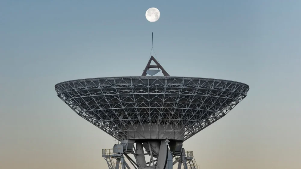
    The Intuitive Machines space-to-ground network combines a lunar data-relay constellation with a global ground segment to maintain persistent line-of-sight communications with the Moon. Goonhilly is expected to enhance this architecture with deep space assets, including the GHY6 32-meter antenna, the cryogenically cooled GHY3 30-meter antenna, and multiband support across X-band, S-band, and Ka-/Ku-band. This will give customers greater flexibility in mission design and more options for communicating with spacecraft throughout lunar and deep space operations.

    “Goonhilly has spent years building a world class deep space communications capability,” said Kenn Herskind. Executive Chairman of Goonhilly. “Joining Intuitive Machines will allow us to scale that capability globally and directly support the next era of lunar exploration. Together, we will be creating a commercial lunar communications network that is interoperable, resilient, and ready to support Artemis and international missions.”

    The transaction is expected to close in the third quarter of 2026, subject to customary closing conditions, including the receipt of applicable regulatory approvals, including under the UK National Security and Investment Act 2021 and from the U.S. Federal Communications Commission.

  • GNSS-IR aids in water-level research

    GNSS-IR aids in water-level research

    Cost-effective sensors from the University of Bonn are measuring water levels along rivers and coastlines in Africa and the Pacific region.

    Using a low-cost sensor and GNSS Interferometric Reflectometry (GNSS-IR), river water levels can be monitored around the clock. The water-level data are automatically transmitted via cellular networks to an analysis center.

    Researchers at the University of Bonn developed the method several years ago and tested it on the Lower Rhine. With support from the European Space Agency (ESA), the monitoring system is now also being used in Africa and the Asia-Pacific region.

    Researchers at the Institute of Geodesy and Geoinformation at the University of Bonn, led by Makan Karegar, have transferred water -level monitoring technology from the Rhine to Africa, Australia and the Philippines as part of ESA projects. Originally developed in the DFG Collaborative Research Center SFB 1502 (DETECT), the technology enables continuous, freely accessible monitoring of inland and coastal waters in data-poor regions worldwide.

    Active on three continents

    The technological centerpiece is the Raspberry Pi Reflector (RPR), a compact, solar-powered sensor developed at the University of Bonn. Using GNSS-IR, it measures water levels with centimeter-level accuracy.

    Only a portion of the signals emitted by the GNSS satellites is directly captured by the antenna. The rest is reflected by the water surface and reaches the receiver via this detour. When superimposed with the directly received signal, it forms specific patterns known as interference patterns. These can be used to calculate the distance from the antenna to the water surface.

    Each unit costs less than 800 euros, is powered by solar energy, and transmits data daily via mobile networks. “Modern gauge stations are prohibitively expensive, and conventional ones are highly vulnerable to flood damage,” said Makan Karegar, project manager. “These two factors together have left many countries in the global south with little to no ground-based water-level monitoring. The low-cost GNSS-IR sensor was developed precisely to address this gap.”

    CAMEO-WAGST Project

    The CAMEO-WAGST project (“Cameroon Advanced Measurements for Enhanced Observations of Water levels using Affordable GNSS-IR and Sentinel-3 & 6 Technology”) has established the first dedicated GNSS-IR network for monitoring water levels along coasts and rivers in Camroon and was funded by ESA. Between May and June 2025, researchers collaborated with Loudi Yap, director of the Research Laboratory in Geodesy at the National Institute of Cartography to install eight RPR sensors in Cameroon: two on the Sanaga River and six along the coast. “A lack of infrastructure for reliable hydrological and coastal monitoring in Cameroon has so far hindered effective flood risk management and early warning systems,” Yap said.

    This collaboration, under the umbrella of the EO Africa Research and Development Facility, is already bearing fruit, said Roelof Rietbroek, research coordinator at ESA’s EO Africa R&D Facility. “We hope this paves the way for more reliable monitoring of flood-prone regions in Africa.”

    St3TART-FO Project

    Building on this success, the follow-up project St3TART-FO also was launched in collaboration with ESA. A total of 17 RPR sensors will be installed in seven countries, including West Africa, Australia and the Philippines. “The goal is to create a freely accessible reference measurement network for calibrating satellite data,” Karegar said. For the first time, the network will provide continuous water-level data at previously unmonitored locations.

    The collaboration is based on years of scientific exchange between Africa and Europe. Partners include:

    • International Institute for Water and Environmental Engineering (2iE), Burkina Faso
    • National Institute of Cartography, Cameroon
    • Environmental Protection Authority (EPA), Ghana
    • Nigeria Hydrological Services Agency (NiHSA)
    • University of Maiduguri, Nigeria
    • Assane Seck University of Ziguinchor, Senegal
    • University of Southern Queensland, Australia
    • University of the Philippines Diliman.

    Technology Transfer and Capacity Building

    Both projects promote technology transfer and local capacity building through training, workshops and mentoring, enabling partner institutions to operate RPR networks independently. “We want to leave behind a sustainable monitoring capacity that is operated by local scientists and institutions, openly shared with the world, and maintained well into the future,” Karegar said.

    With financial support from the Transdisciplinary Research Area (TRA) “Sustainable Futures” at the University of Bonn, Karegar developed the open-access data platform gnss4surfacewater.com, which provides an independent, ground-based service for monitoring current and historical water levels using GNSS-IR. Also visit CAMEO-WAGST GitHub for code and field photos.

  • Beyond Gravity delivers key payload components for ESA’s Celeste

    Beyond Gravity delivers key payload components for ESA’s Celeste

    Beyond Gravity has delivered key payload components for the ESA’s Celeste project aimed at making existing satellite navigation systems more accurate and resilient. The first demo satellites were launched into space on March 28. Beyond Gravity wants to further extend its payload offerings.

    The European Space Agency (ESA) is embarking on a demonstration mission of 11 satellites in orbit to test and demonstrate the benefits of an additional layer of PNT (positioning, navigation and timing) in low Earth orbit. This will further improve the accuracy and responsiveness of Europe’s satellite navigation system, even during jamming and spoofing attacks. Celeste demonstrates how this additional layer can complement the resilience, security and precision of the European navigation system Galileo.

    The first two demonstration satellites of the new Celeste navigation mission were launched into space on March 28.

    “Key electronics for the Celeste satellite payload are provided by Beyond Gravity,” said Oliver Grassmann, chief operating officer at Beyond Gravity. “Expanding our payload capabilities is a top priority, as we continue to deliver high‑performance solutions for diverse missions — including radio occultation, reflectometry, electronic signal intelligence, and positioning, navigation, and timing.”

    Kurt Kober, vice president, Electronic Solutions at Beyond Gravity, highlights the company’s key contributions to Celeste. “We play an important role in this mission and supply cutting-edge technology for digital signal generation and the clock for the satellite instruments,” Kober said. “These components ensure high reliability of the navigation signals as well as time accuracy and stability.”

    Apart from the payload components, the company also supplied highly sensitive antennas. ESA has chosen Beyond Gravity as a key payload partner for Celeste alongside the Spanish space company GMV (prime contractor) and OHB in Germany.

    Making Galileo more secure

    The new Celeste navigation satellites in low Earth orbit will demonstrate how an additional layer in a low-earth orbit around 500 km could complement the larger Galileo navigation satellites at an altitude of around 23,000 kilometers and make them more secure. This new satellite mission is known as Celeste, ESA’s first initiative in Low Earth Orbit PNT (LEO-PNT).

    The in-orbit demonstrator phase for Celeste is being executed by two European consortiums in parallel and will comprise a total of 11 satellites plus one spare. GMV, as one of the prime contractors, is responsible for the complete end-to-end mission, including system definition and design, the space and ground segments, the user segment and operations, for 6 of the demonstrator satellites.

    Importance of satellite payloads

    The payload comprises those elements of a satellite that perform its actual task, in the case of Celeste the creation and transmission of navigation signals. “We have already delivered important satellite instruments, like our radio occultation weather instruments, and a reflectometer payload,” Kober said. “We also supplied payload elements in the field of signal generation for the European satellite navigation system Galileo. This expertise has been incorporated into the Celeste project.”

    Kober sees satellite payloads as an important area for future business. “We want to play a greater role in this core area of satellites, the payload.”

    Modular payload solution

    With its FoX electronics platform, Beyond Gravity offers a flexible and modular solution that can host different payloads. Examples for such possible payloads include electronic signal intelligence (ELINT), which can be used for detecting and characterizing radar signals, or a PNT (positioning, navigation, timing) payload.

    Other possible payloads from Beyond Gravity are its radio occultation and reflectometry instruments as well as high-resolution earth observation images (optical payload from a third-party supplier).

    The FoX electronics platform, together with the payloads selected for the customer, can be easily integrated into Beyond Gravity’s satellite platform (multi-purpose platform), which successfully passed its Preliminary Design Review and is now undergoing intensive tests.

  • ESA’s Celeste IOD-1 satellite transmits first navigation signal

    ESA’s Celeste IOD-1 satellite transmits first navigation signal

    Celeste will test a complementary low-Earth-orbit layer for Galileo for more robust and accurate navigation.

    At 10:38 CET on April 8, the Celeste IOD-1 satellite, developed by GMV and Alén Space under the European Space Agency’s (ESA) Celeste In-Orbit Demonstrator (IOD) program, successfully transmitted its navigation signal for the first time.

    The reception of the signal from the Celeste IOD-1 satellite, confirmed by ESA teams at ESTEC, marks a key milestone for the program as it confirms the satellite’s successful commissioning in orbit. The signal was also received at GMV’s monitoring station in Lisbon.

    The first two IOD satellites of the Celeste program — built by GMV and Thales Alenia Space, respectively — were launched March 28 at 10:14 CET from Rocket Lab’s Launch Complex 1 in Mahia, New Zealand. Separation from the launch vehicle took place one hour later, marking the start of the initial operations phase (LEOP) and commissioning, carried out by GMV for the IOD-1 satellite from the mission control center in Tres Cantos.

    Next-generation LEO navigation

    Celeste is ESA’s strategic program to demonstrate the benefits of an additional low Earth orbit (LEO) navigation layer that complements Galileo and EGNOS, with the goal of improving the accuracy, resilience and security of positioning, navigation and timing (PNT) services in Europe.

    The in-orbit demonstrator (IOD) represents the program’s first phase and will validate key LEO-PNT technologies in flight ahead of potential future operational deployment.

    The Celeste IOD phase is being carried out in parallel by two European consortia and will include a total of 11 satellites plus one in-orbit spare. As one of the prime contractors, GMV is responsible for the end-to-end mission for six of the demonstrator satellites, including system definition and design, the space and ground segments, the user segment, and operations.

    Celeste program beginnings

    The Celeste program began with two demonstrator satellites, IOD-1 and IOD-2, aimed at securing registered frequency allocations and testing representative navigation signals through the end of the year. The mission will demonstrate precise autonomous orbit determination without relying on ground infrastructure, as well as stronger radionavigation signals in the L- and S-bands from low Earth orbit.

    By demonstrating the advantages of integrating LEO capabilities into a multi-orbit architecture alongside Galileo (MEO), Celeste aims to improve resilience to interference and expand advanced navigation services. Operating at altitudes between 500 and 560 km, the Celeste demonstrators will assess how a complementary LEO layer can enhance Europe’s Galileo system in medium Earth orbit.

    Eight additional, larger satellites are currently under development to extend the capabilities of the initial demonstrators. These will form part of the full fleet (eleven operational spacecraft and one spare) and will pave the way for subsequent launches starting in 2027.

    GMV was selected in 2024 by the European Space Agency (ESA) to lead one of the parallel contracts for the development of Celeste. The first satellite in the constellation, a 12U CubeSat named Celeste IOD-1, was jointly developed by GMV and Alén Space.

    In recent months, Celeste IOD-1 has undergone a complex assembly and integration process, as well as rigorous environmental and system testing. The results of these tests, carried out at GMV’s facilities, confirmed that the satellite was ready for launch, as well as for initial LEOP (Launch and Early Orbit Phase) operations and in-orbit experimentation activities.

  • Net Insight leads development of next-generation PNT technology

    Net Insight leads development of next-generation PNT technology

    Focusing on timing synchronization, the project is supported by ESA NAVISP on behalf of the Swedish National Space Agency to advance resilient timing and positioning.

    Net Insight has been awarded a development project through the European Space Agency’s Navigation Innovation and Support Program (NAVISP), a European program designed to foster innovation in the PNT domain and strengthen Europe’s technological competitiveness. 

    The project, co-funded by the Swedish National Space Agency, aims to accelerate the development of robust positioning, navigation and timing (PNT) technology, to address growing societal needs and increase risks to critical infrastructure.

    Precise timing signals are a critical component of everything from telecommunications and 5G networks to transportation and energy systems. Traditionally, GNSS systems such as GPS and Galileo have been the standard for time synchronization. However, today’s geopolitical landscape and the increasing prevalence of disruptions such as jamming and spoofing highlight the need for robust, complementary solutions that can ensure reliable operation under all conditions, according to Net Insight.

    “This initiative exemplifies how the Swedish space industry can contribute to addressing complex European challenges related to critical infrastructure,” said Christer Nilsson, vice director general of the Swedish National Space Agency. “Combining Swedish technical excellence with European collaboration is a powerful model for strengthening robustness and operational reliability within PNT.”

    “Society depends on technologies that are not only advanced, but also robust and operationally reliable, and capable of withstanding disruptions and external interference,” said Per Lindgren, group CTO and head of synchronization at Net Insight. “With this project, we are strengthening the development of solutions that can deliver reliable time synchronization even under demanding conditions, thereby securing critical infrastructure for the future.”

    Through collaboration with the Swedish National Space Agency and ESA’s NAVISP program, the project gains access to both national and European funding and support for research and development in PNT technology. At the same time, it enables national initiatives to be aligned with broader European strategies for robust and operationally reliable PNT architectures.

    NAVISP is designed to stimulate new technologies and applications beyond traditional GNSS-based systems and plays a key role in Europe’s efforts to ensure robust and competitive PNT solutions.

  • Unifly & Nexova complete NAVISP phase to advance cyber-resilient U-space operations

    Unifly & Nexova complete NAVISP phase to advance cyber-resilient U-space operations

    Unifly, in cooperation with Nexova, have successfully completed the SecureUTM 2 Phase I under the European Space Agency’s (ESA) NAVISP program, with emphasis on mitigating GNSS jamming and spoofing.

    The project establishes a certification-aligned, risk-driven cybersecurity foundation for secure, resilient and scalable unmanned traffic management (UTM) and U-space services across Europe. 

    As drone operations grow in complexity and cross-border interoperability, cybersecurity is becoming essential for operational continuity and public trust. SecureUTM 2 embeds cybersecurity engineering into the core architecture of UTM systems, aligning with European U-space regulations, Common Criteria methodology and ENISA risk frameworks. Security is treated as a foundational design principle rather than a late-stage compliance requirement. 

    Building on SecureUTM 1, SecureUTM 2 Phase I significantly expanded the cybersecurity baseline for UTM systems. Key outcomes include: 

    • Refinement of a harmonized Protection Profile (PP) for UTM 
    • Development of an updated Security Target (ST) for the Unifly platform 
    • Structured risk assessment and certification-aligned gap analysis 
    • Definition of a secure architectural baseline addressing real-world U-space complexity 
    • Setup of a PoC Testbed 

    Risk-based engineering roadmap

    A control-by-control gap assessment translated cybersecurity requirements into a prioritised implementation roadmap. Focus areas include: 

    • PNT source authentication and plausibility checks 
    • Enhanced session integrity and transport protection 
    • Denial-of-Service resilience 
    • Device-level authentication and auditing 
    • Secure storage and encryption 

    This structured approach supports operational deployment and future EU cybersecurity certification readiness. 

    Validated mitigations for GNSS and PNT threats

    SecureUTM 2 phase I placed strong emphasis on GNSS jamming and spoofing risks increasingly observed in drone operations. Practical, layered mitigations were validated through a dedicated U-space proof-of-concept testbed with Hardware-in-the-Loop UAV simulations. 

    Validated measures include: 

    • On-board GNSS jamming detection 
    • Fleet-level interference inference 
    • Trajectory plausibility and conformance monitoring 
    • OSNMA-based message verification 
    • Structured anomaly logging and alerting 

    The testbed enables repeatable attack simulation, KPI-based evaluation and regulator-ready evidence generation. 

    Foundation for Phase II and European deployment

    Phase I also delivered a structured U-space testbed blueprint, verification methodologies and digital twin foundations to support continued validation, operator training and continuous cybersecurity testing. 

    SecureUTM 2 directly supports Belgium’s U-space deployment strategy and strengthens its position in secure drone integration. 

    Phase II will focus on implementing prioritised controls, expanding validation capabilities and further aligning with EU certification frameworks. 

  • Ultra-low-noise amplifiers achieve in-orbit milestone on ESA HydroGNSS mission

    Ultra-low-noise amplifiers achieve in-orbit milestone on ESA HydroGNSS mission

    Ultra-low-noise amplifiers developed by European Engineering Consultancy Ltd. (EECL) are operating in orbit on the European Space Agency’s (ESA’s) HydroGNSS mission, marking a technical milestone for the hardware following the satellites’ launch in November 2025.

    HydroGNSS consists of two small satellites designed to measure hydrological and climate-related variables using GNSS reflectometry. The satellites collect signals transmitted by navigation satellites such as GPS and Galileo and analyze those signals after they reflect from Earth’s surface. The reflected signals provide data on environmental parameters including soil moisture, freeze–thaw conditions in permafrost regions, wetlands and inundation, and above-ground biomass.

    The satellites were launched aboard a SpaceX Falcon 9 rideshare mission from Vandenberg Space Force Base in California on Nov. 28, 2025. The mission is part of the European Space Agency’s Scout program, which focuses on relatively small and cost-effective Earth observation satellites designed to demonstrate new measurement techniques.

    EECL designed and manufactured six multiband ultra-low-noise microwave amplifiers used in the spacecraft payload. The amplifiers are part of the radio-frequency front end of the receiver system and are designed to amplify very weak reflected GNSS signals while minimizing additional noise, helping preserve signal quality for scientific analysis.

    Early on-orbit results indicate the satellites’ payloads are functioning as expected. Both spacecraft have begun collecting delay-Doppler maps of reflected GNSS signals, an early step in commissioning that confirms the receivers are acquiring and processing signals properly.

    The HydroGNSS satellites were built by Surrey Satellite Technology Ltd., which also developed the GNSS receiver used on the mission. The spacecraft operate in low Earth orbit and are phased apart to increase global coverage of the measurements.

    Data from HydroGNSS are expected to support research on the global water cycle and contribute to studies related to climate monitoring, agriculture, flood risk and ecosystem changes.

  • BeaconSat aims to make GNSS attacks visible with Austria’s first military satellite

    BeaconSat aims to make GNSS attacks visible with Austria’s first military satellite

    Austria is breaking new ground in space. BeaconSat is the largest satellite ever developed in Austria and also the country’s first military satellite. The project is being led by Austrian start-up GATE Space, based in Schwechat. Launch is planned for February 2027 aboard a SpaceX Falcon 9 rocket.

    BeaconSat is designed to detect and analyze jamming and spoofing attacks on GNSS — targeted attempts to interfere with and manipulate navigation signals such as GPS or Galileo. Austria is responding to a security policy development that has real implications for aviation, transport, energy supply, and military operations.

    Attacks on critical infrastructure

    Jamming and spoofing incidents are frequent in geopolitically tense regions. In aviation, repeated disruptions have affected civilian aircraft.

    “Space is now a central component of Europe’s and Austria’s security and defense strategy,” said Major General Friedrich Teichmann, head of the ICT and Cybersecurity Center. Navigation signals have long been part of critical infrastructure, and securing them is therefore of great strategic importance.

    However, many of these attacks remain invisible. Countries often do not know where the interference is coming from, how systematic it is, or what pattern lies behind it. This is where BeaconSat comes in.

    Technology demonstrator with strategic dimension

    BeaconSat will systematically detect and analyze GNSS interference signals from orbit for the first time. The aim is to obtain data on when and where navigation systems are being deliberately disrupted. The mission is designed as a multi-year research and development project.

    “It is important that we are able to act independently in terms of communication and navigation when necessary. This is a question of resilience and military capabilities,” emphasized Defense Minister Klaudia Tanner. “Space is an essential part of military capability.”

    The satellite is not intended to be an isolated military project, but rather a demonstrator. Civil space technologies are being further developed for security-related applications and tested under real-world conditions. The findings will be incorporated into the operational processes of the Federal Ministry of Defense (BMVL).

    Austrian industry at the center

    GATE Space has overall responsibility for the project. Founded in 2022, the spin-off from TU Wien develops chemical propulsion systems for satellites and currently employs around 27 people. For BeaconSat, the company is supplying the propulsion system, the satellite structure, and the thermal management system, among other things.

    “With BeaconSat, we are making a direct contribution to Europe’s security. The market for such capabilities is huge,” said Managing Director Moritz Novak.

    The engines were tested in more than 8,000 hot runs at the site near Vienna Airport, both under atmospheric conditions and in one of Europe’s most powerful vacuum chambers.

    GATE Space was supported by the Federal Ministry for Innovation, Mobility, and Infrastructure (BMIMI) through Austria Wirtschaftsservice (aws) with funding of around 750,000 euros.

    Jamming and spoofing detection

    A central contribution to the payload comes from the Graz-based company IGASPIN, which develops systems for the precise detection and analysis of GNSS interference. Additional components, including the on-board computer, are supplied by the Danish company Space Inventor.

    At the European level, the mission is supported and co-financed as a technology demonstration via the European Space Agency’s ESA Marketplace. Off-the-shelf systems are specifically used to test commercially available technologies under security-relevant conditions.

    New space chapter in the Ministry of Defense

    BeaconSat also marks a turning point institutionally. The BMLV is currently setting up its own organizational unit for space services. The focus is on three areas: satellite communication, satellite navigation, and satellite-based reconnaissance.

    “These space services are key to cross-domain operations and make a substantial contribution to the Austrian Armed Forces’ modern reconnaissance, command, and control network,” Teichmann said.

    BeaconSat will provide data that will be directly integrated into military decision-making processes. At the same time, the project contributes to European resilience: those who recognize threats early on can respond diplomatically, politically, or technically.

    Space as a growth area

    The strategic importance of space technologies is growing both in terms of security policy and economics. Austria has recently increased its contribution to the ESA from 260 to 340 million despite budgetary constraints. Space and aviation technologies are anchored in the government’s industrial strategy as one of nine key technology fields.

    Satellites have long been considered critical infrastructure. They enable navigation, communication, Earth observation, climate monitoring, and security applications. At the same time, new markets are emerging in the areas of propulsion systems, data analysis, and dual-use technologies.

    With BeaconSat, Austria is repositioning itself in terms of security policy and industry. The project is an example of how startups, established technology companies, ministries, and European partners can and must work together successfully.

  • GNSS-reflectometry data unlocks new insights into Arctic sea ice

    GNSS-reflectometry data unlocks new insights into Arctic sea ice

    In recent years, scientists have shown that detecting changes in navigation signals from GPS and Galileo after they bounce off Earth’s surface (GNSS reflectometry, or GNSS-R) can deliver valuable information on sea ice. Now research drawing on data from Spire Global has enabled the generation of Arctic-wide sea ice maps, marking a major step forward for the emerging technique.

    Spire Global‘s sea ice freeboard maps use data captured by Spire’s GNSS-reflectometry multipurpose listening constellation.

    The research — enabled by the Third Party Missions (TPM) programme of the European Space Agency (ESA) — suggests that harnessing reflected navigation signals could become an important complement to established ice-monitoring altimetry missions.

    The study leveraged Spire’s GNSS-R data to retrieve sea ice freeboard measurements across an entire winter season. The results show strong alignment with established altimetry datasets, including the ESA’s CryoSat mission, validating the complementary role of commercial satellite data alongside government missions.

    Arctic-wide sea ice freeboard map for January 2024
Arctic-wide sea ice freeboard map for January 2024. (Credit: ESA)
    Arctic-wide sea ice freeboard map for January 2024. (Credit: ESA)

    The study was led by Felix Müller at the Technical University of Munich (DGFI-TUM) and Robert Ricker at the Norwegian Research Centre, experts in GNSS-R.

    “The primary purpose of signals emitted from GNSS is to fix the location of a device at any point on Earth,” Müller explained. “However, when these signals bounce off Earth’s surface, their properties change. By analyzing these changes, we can infer information about the characteristics of Earth’s surface.”

    “Previous research has shown that this technique works well experimentally,” Ricker added. “Using the Spire constellation, we aimed to demonstrate whether it would hold up on a larger scale by generating an Arctic-wide map of sea ice freeboard, which is a measure of how far ice protrudes above the waterline.”

    Spire’s GNSS-R constellation

    Spire’s constellation was first used to sample the atmosphere for weather forecasting. Then scientists began exploring other applications. Spire started collecting reflected signals arriving at shallow angles using a technique called grazing-angle GNSS-R. This method is particularly well suited for ice monitoring.

    The research team analyzed data detected over the Arctic Ocean and surrounding seas between October 2023 and July 2024. The data was obtained via the TPM program, through which ESA disseminates data from a range of commercial and institutional partners on a free basis for research and development purposes.

    The team focused on one of the most critical challenges in sea ice altimetry: reliably identifying narrow openings in the ice pack, known as leads. These openings are reference points for determining sea surface height and, ultimately, sea ice freeboard.

    In turn, sea ice freeboard can be used to infer sea ice thickness — an essential parameter for tracking climate change, estimating sea level, and modeling ocean and weather patterns.

    Identifying leads in sea ice with GNSS-R data. (Credit" ESA)
    Identifying leads in sea ice with GNSS-R data. (Credit: ESA)

    Classifying surface properties

    “In the initial phase of the project, we used two complementary methods to identify surface properties based on GNSS-R data, with the aim of identifying leads,” Müller said.

    The first — known as the adaptive threshold technique — involved measuring the power of the reflected navigation signal to classify surface type as either water or ice. This method allows rapid processing of the entire GNSS-R dataset, while remaining robust to changes in signal conditions.

    The second method — known as unsupervised clustering — offers a more complex approach to classifying surface conditions. In addition to signal power, it considers multiple other signal features that tease out more nuanced information on surface type, including identifying thin or refrozen ice.

    Both methods were compared with co-located CryoSat surface-type classifications and Sentinel-1 imagery, confirming that the GNSS-R classifications were largely comparable against conventional satellite products.

    Mapping sea ice freeboard

    “Building on this classification work, we then took the research to the next step by producing Arctic-wide sea ice freeboard maps from GNSS-R data,” Ricker said.

    The team corrected ice surface height measurements generated from GNSS-R data for tidal variations, sea surface height, and atmospheric delays, which is standard practice in altimetry. A refined algorithm then identified where leads in the ice were likely to occur, with the lowest points in these areas revealing estimated sea surface height. Sea surface height estimates were then subtracted from ice surface heights to retrieve freeboard. Using this approach, monthly gridded freeboard products were generated for the full winter season.

    The team reported that the GNSS-R datasets showed strong agreement with CryoSat freeboard datasets across much of the Arctic, confirming that GNSS-R can reproduce large-scale patterns previously observed by dedicated altimetry missions. Independent validation against upward-looking sonar measurements in the Beaufort Sea further supported the accuracy of the retrieved freeboard values.

    However, as expected, the GNSS-R estimates became less reliable during spring, when surface melt alters reflection characteristics. This limitation is consistent with earlier GNSS-R and radar altimetry studies and remains an active area of research.

    The contribution of commercial data

    While GNSS signals have long been used for positioning, this research highlights how reflected signal analysis can extend their value into large-scale Earth observation applications, delivering persistent coverage independent of sunlight or weather conditions, said Theresa Condor, Spire Global CEO.

    “Advances in miniaturization, digital signal processing, and machine learning have fundamentally changed what’s possible in RF sensing,” Condor said. “Commercial constellations can now deliver persistent, high-quality RF data that complements traditional government systems with greater flexibility and cost efficiency.

    “As environmental monitoring requirements intensify, we’re seeing agencies increasingly integrate commercially sourced RF datasets into operational architectures, reflecting the continued maturation of this market and the growing role of commercial infrastructure in government missions.”

    “By producing analysis-ready gridded datasets, this work marks an important milestone in the progress of grazing angle GNSS-R from an experimental method to a reliable technique for mapping Arctic sea ice freeboard at scale,” said Matthieu Talpe, Remote Sensing Product Engineer, Spire Global. “In doing so, it strengthens the case for the grazing angle GNSS-R technique employed by the Spire constellation as a valuable complement to existing ESA and partner missions, helping to close observational gaps in one of Earth’s most rapidly changing regions.”

  • Spirent partners with ESA to spearhead PNT resilience initiative for critical infrastructure

    Spirent partners with ESA to spearhead PNT resilience initiative for critical infrastructure

    Project establishes innovative test framework to help UK operators, providers and suppliers adopt best practice and benchmark success

    Spirent Communications, now part of Keysight Technologies, has partnered with the European Space Agency (ESA) to lead an initiative aimed at increasing the resilience of positioning, navigation and timing (PNT) systems used in critical national infrastructure. Under the initiative, Spirent and partners will deliver a comprehensive test framework to drive measurable resilience in PNT systems for users, operators and providers of critical infrastructure in the United Kingdom.

    Supported by Element 2 of ESA’s Navigation Innovation and Support Program (NAVISP), the initiative is designed to raise awareness and improve resilient PNT test and assessment by providing a pathway to assess, validate and rate PNT equipment and services used in critical national infrastructure. The 2023 UK government report The Economic Impact on the UK of a Disruption to GNSS estimates a seven-day GNSS outage could cost the UK economy £7.6 billion. Critical infrastructure is heavily dependent on satellite-based PNT systems and data.

    “For years, organizations have been wrestling with a fundamental challenge: they know PNT resilience matters, but they do not have a clear way to measure it or benchmark their progress,” explained Mark Holbrow, vice president of Engineering and Product Development at Spirent Positioning. “This new initiative changes that by building the tools and frameworks that let critical national infrastructure operators quantify resilience, track it, and improve it over time, and we’re proud that ESA has entrusted Spirent to lead this exciting three-year project.”

    The Resiliency in Critical National Infrastructure will support the UK government’s resilient PNT strategy by enabling access to rigorous, quantitative test evidence and operational insights that help evaluate and validate PNT systems across essential sectors. It will comprise three core components:

    • Spirent PNT Alliance brings together companies, academic research partners, and PNT professional and government bodies to identify, develop and cater resilience services for critical infrastructure. It will include the Royal Institute of Navigation and other strategic partners to complement their activities and help build a resilient PNT ecosystem in the UK by commercializing best practices and connecting infrastructure operators with new technologies and test approaches.
    • PNT Shopfront showcases solutions that aid the adoption of resilient PNT and help to assure regulatory compliance for critical PNT dependencies.
    • PNT Resiliency Health Check will enable independent appraisal of GNSS equipment capability against general performance, resilience and security criteria. Annual health check assessments will help organizations understand their dependencies, identify vulnerabilities, and track improvements over time, with a technical framework that scores resilience against standard benchmarks to create a pathway toward industry-wide test methodologies.

    “Intentional and malicious disruptions to GNSS are now a daily occurrence, and are pervasive in the aviation and maritime sector,” said Ramsey Faragher, director of the institute. “The Royal Institute of Navigation is focused on raising awareness to these issues and in promoting the needs for improved resilience against such disruptions, especially within Critical National Infrastructure. Our Best Practice Guidelines emphasize the criticality of thorough testing in order to verify resilience and to help protect against both existing and future attack vectors. The UK is well placed to take a lead in this area, and well placed to inspire other nations to follow suit. We are really pleased to see initiatives like these from our corporate partners, and we look forward to supporting them.”

  • ESA celebrates 30 years of Galileo

    ESA celebrates 30 years of Galileo

    To celebrate 30 years of the Galileo global navigation system, the European Space Agency created the following video. Astronomer Galileo Galilei makes an appearance.

    “Three decades of challenges and triumphs that have shaped the navigation systems we rely on today: EGNOS and Galileo, and that serve as a legacy to building the satellite navigation systems of tomorrow,” states ESA.

     In October 1995, the ESA Council at Ministerial Level approved ARTES Element 9, initiating the studies and development of GNSS-1 (EGNOS) and GNSS-2 (Galileo). However, the first steps leading to this moment started as early as the 1980s, with pioneering research and studies conducted by ESA, national space agencies and European institutes.

    Learn more about the history of Galileo.

  • SpacePNT completes qualification testing for second-gen spaceborne GNSS receiver

    SpacePNT completes qualification testing for second-gen spaceborne GNSS receiver

    SpacePNT SA, a global provider of high-accuracy, radiation-tolerant spaceborne GNSS receiver equipment for missions ranging from Earth to cislunar orbit, has completed extensive qualification testing of its second-generation product, including vibration, shock, thermal vacuum and electromagnetic compatibility tests.

    The multi-frequency, multi-GNSS receiver resulted from two European Space Agency (ESA) ARTES Competitive & Growth (C&G) development projects supported by ESA and the Swiss Space Office.

    The first project enabled SpacePNT to develop an industrialized second-generation product for large-scale production targeting low-Earth orbit, LEO position-navigation-timing and geostationary orbit telecommunications constellations. The receiver includes a proprietary Precise Orbit Determination algorithm that provides sub-decimeter real-time positioning and timing aboard spacecraft. The company validated the POD algorithm in a hardware-in-the-loop environment and retrofitted it into two first-generation flight models delivered to a customer for satellite integration.

    Under the second project, SpacePNT developed a Radiation Hardiness Assurance approach for long-duration missions in harsh radiation environments. ESA’s GENESIS satellite mission, which will operate in a challenging medium Earth orbit environment, will be the first to use this RHA approach. SpacePNT will supply the mission’s GNSS receiver equipment.

    Though the second-generation receiver uses largely the same hardware, software and firmware technology as the company’s flight-proven first-generation product, SpacePNT performed a complete qualification campaign to validate design changes.

    After passing all qualification and performance tests, SpacePNT will begin manufacturing first flight models of its second-generation products for several customers. The receivers will fly on demanding Earth observation, in-orbit servicing and space exploration missions at altitudes from LEO through medium Earth orbit, geosynchronous transfer orbit, geostationary orbit and lunar distances.

    The views expressed herein do not reflect the official opinion of the European Space Agency.